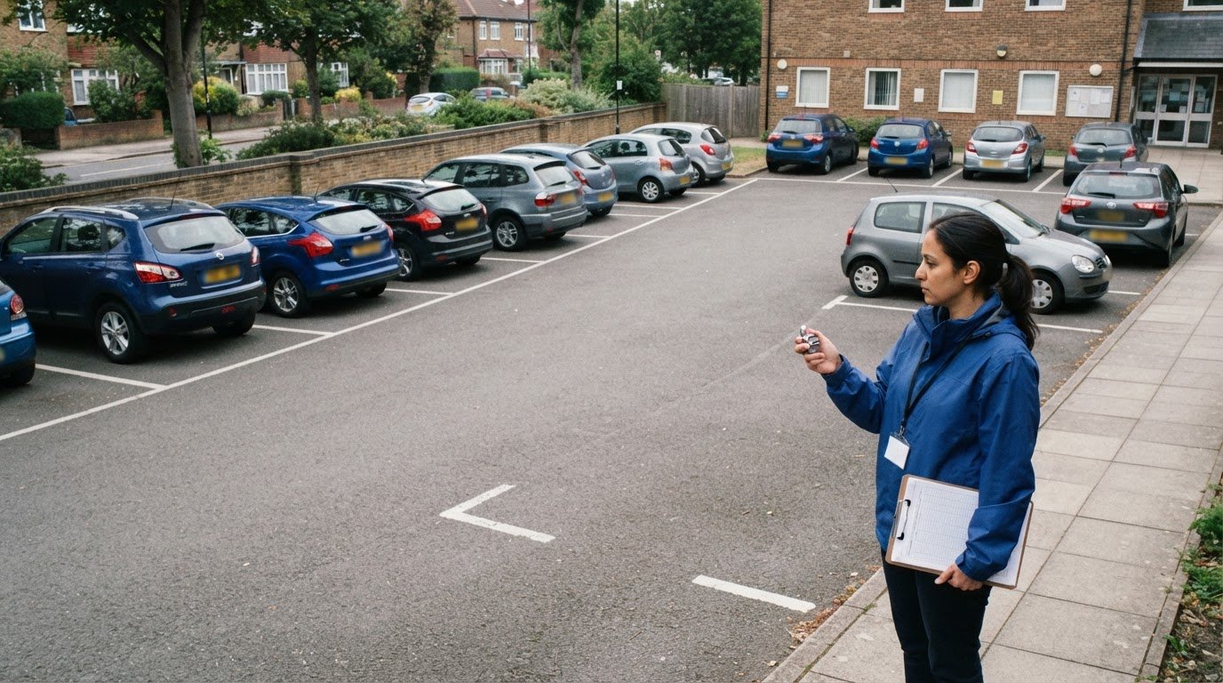
A single peak occupancy figure can hide how parking demand changes through the day. A car park accumulation study counts vehicles parked within a defined area at set times, showing how occupancy rises and falls. To understand what a car park accumulation study is, focus on the sequence of counts, not just the busiest moment: consistent observations create a picture of parking use over time.
The count itself is straightforward, but useful findings depend on choosing a study boundary and observation period that reflect how the site operates. The interval between observations also matters because it determines how much detail the results show. Clear tables and diagrams make the method easier to follow and the patterns easier to interpret.
This guide explains how to choose the study area and period, set survey intervals, calculate accumulation from recorded counts, and present the results in tables and diagrams. It also shows how to make the findings clear, so readers can see how parking use changes across the survey period.
Key Takeaways
- Define the car park boundary and the question the survey needs to answer before planning observations.
- Choose a survey period that captures the parking activity relevant to the site, then use consistent observation intervals.
- Present counts in an accumulation table and diagram so changes in occupancy are clear across the survey period.
- Calculate accumulation from the vehicles recorded at each observation, keeping the counting method consistent throughout.
- Use a professionally delivered Parking Survey when reliable parking-use data is needed to support transport planning.
Survey timing and observation intervals
Plan the observation period around the parking activity being assessed, then use consistent intervals. Published parking survey examples use monitoring intervals from 10 to 60 minutes; the right spacing depends on how much detail the study needs.
-
Set Observation Times and Intervals
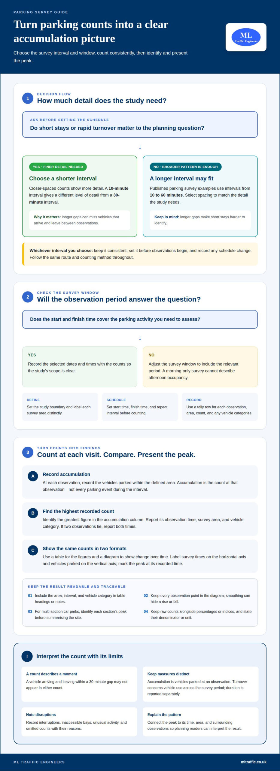
Set a start time, finish time and repeat interval before observations begin. In the UK, surveyors record the vehicles parked within the defined area at each observation, following the same route and method throughout. A 30-minute interval gives a different level of detail from a 10-minute interval.
Choose an interval suited to expected turnover and the purpose of the assessment. Longer gaps can miss vehicles that arrive and leave between counts, making short stays harder to identify. Keep the interval consistent, and avoid changing the survey schedule mid-study unless you record the change.
-
Prepare Accumulation Tally Sheets
Prepare a tally sheet with one row for each observation time and clear fields for the area, date, count and any vehicle categories being recorded. For example, a 09:00 observation row should be completed before the next scheduled count. Give each survey area a distinct label to prevent counts being assigned to the wrong section.
Use the same recording terms on every sheet. Leave space for brief notes about access restrictions, unusual activity or a disrupted observation. These notes can explain a count that differs from nearby entries. Check that every scheduled time has a completed count or a recorded reason for an omission.
-
Match the Survey Window to the Planning Question
Choose start and finish times that capture the period relevant to the site, such as a busy operating period or a typical working day. A survey covering only the morning cannot describe afternoon occupancy. Record the selected dates and times alongside the counts to make the study’s scope clear.
For planning applications and Transport Assessments, accumulation results can show how parking demand changes during the observed period. The evidence describes peak occupancy and whether demand remains steady or fluctuates. Interpret it alongside the survey’s defined area, dates and observation intervals.
-
Record Limitations as They Occur
Record interruptions, inaccessible bays and other conditions that affect a count, rather than treating every observation as complete. A survey interval can also miss brief stays between visits. For example, a vehicle arriving and leaving within a 30-minute gap may not appear in either count.
Accumulation counts describe occupancy at observation times, not every parking event. Keep tally sheets and field notes together, and state the interval used when presenting results. This makes the method and its limitations clear to planning readers.
Accumulation tables and diagrams
Identify peak parking demand by finding the highest recorded accumulation, then report the observation time and vehicle count. A table shows the figures, while a diagram makes changes across the survey period easier to see.
-
Calculate Accumulation from Survey Data
Enter each observation’s recorded vehicles in a table, keeping separate rows for times and, where relevant, vehicle categories. Compare the rows to identify the highest number parked at one time. For example, a 60-minute monitoring example recorded demand of 16 motorised two-wheelers and a unique parked-vehicle percentage of 50%.
Keep accumulation distinct from turnover and parking duration. Accumulation counts vehicles parked at an observation; turnover concerns vehicle use across the survey period. Report duration separately, rather than presenting it as peak accumulation. This distinction helps planning readers interpret each measure correctly.
-
Identify Peak Parking Demand
Find the greatest recorded count in the table’s accumulation column. Record its observation time, survey area and vehicle category so readers can see exactly where the peak occurred. If two observations share the highest count, report both times rather than implying there was only one peak.
For a multi-section car park, identify the peak in each section before summarising the site. Keep section-level figures visible because a site-wide total can conceal local pressure. If the study also calculates a parking index or percentile, state its unit and explain what the measure describes. Do not present an index as a vehicle count.
-
Present Results in Tables and Diagrams
Present observation times and accumulated vehicles in a table, then plot the same counts on a diagram. Label the horizontal axis with survey times and the vertical axis with vehicles parked. Use the same units in both formats, and mark the peak count at its recorded time.
Include the survey area, observation interval and vehicle category in the table heading or notes. A diagram should retain every observation point; smoothing the line can hide a sudden rise or fall. Add a concise interpretation stating when the peak occurred and how accumulation changed around it.
-
Make the Findings Useful for Planning
Keep raw counts alongside any derived percentage or parking index so the calculation remains traceable. State the denominator for each percentage and define the unit used for an index. For example, the percentage of unique parked vehicles is not interchangeable with the number occupying spaces at one observation.
Use the findings to explain observed parking demand in a planning assessment, rather than presenting a chart without context. A clear account connects the peak, the relevant section and the survey times. This supports interpretation in a Transport Assessment.
Choosing a study period
Select dates and times that reflect the parking question being assessed. Land use, seasonal patterns and events can all affect recorded accumulation.
- Start with the site’s main activity. Identify whether the car park serves offices, shops, homes, a hospital or a leisure venue. An office site may have a different weekday pattern from a retail car park, while hospital parking can reflect appointments, staff shifts and visiting hours. Choose a period that captures the activity relevant to the assessment, rather than assuming one survey window represents every use.
- Consider the season and calendar. School holidays, Christmas shopping and summer visitor activity can change who travels and when parking demand occurs. A survey during a school holiday may not represent a term-time weekday near a school. Record the season and relevant calendar conditions with the results so readers can understand the context of the observed parking pattern.
- Identify events that could alter demand. A football match, concert, local market or major appointment day can create parking activity outside a site’s usual pattern. Decide whether the study should capture ordinary conditions or a specific event. If an event overlaps the survey, note its timing and location; otherwise, its peak could be mistaken for typical demand.
- Match the survey period to the assessment purpose. For a proposed development near shops, the relevant period may differ from one near offices or a hospital. Set dates and hours that cover the activity the assessment needs to understand, including arrival, stay and departure patterns. A short observation window can omit a later peak, so define what the chosen period can and cannot show.
- Record conditions that affect interpretation. Alongside the counts, note the day of the week, seasonal context, known events and unusual site conditions. For example, a road closure near a town-centre car park may change access and parking choices. Keep those details with the survey results, and distinguish an event-related change from the normal pattern the study aims to describe.
Seasonality, events and land use affect accumulation by changing who visits, when they arrive and how long they stay. Christmas trading, a school holiday or a football fixture can produce a different pattern from an ordinary weekday, so the survey context matters.
Selecting a study area
Draw a clear boundary around the parking spaces included in the survey. That boundary determines which vehicles belong in each count and how the results should be interpreted.
- Define the study question first. Decide whether the survey concerns one car park, a development’s parking provision or parking around a destination. For a single site, identify the spaces relevant to the question being assessed. A boundary that includes unrelated parking can distort the total, while one that excludes relevant spaces may understate demand.
- Map the area and its access points. Mark the included spaces on a site plan and label each section clearly. Show entrances, exits and internal routes so surveyors can identify the correct area at every observation. If a site separates staff parking from visitor parking, label each area separately instead of combining the counts without distinction.
- Distinguish nearby parking from the site. Identify adjacent streets, private car parks and other parking areas before the survey begins. Include them only if they form part of the study question, and record them separately from the main site. For example, a survey of a retail car park should not silently include nearby on-street spaces in its occupancy total.
- Choose a boundary that fits the survey route. Confirm that surveyors can consistently observe all included spaces, including separate courts or parking rows. Mark any area that cannot be seen from the same route. A clear plan helps prevent double-counting spaces or missing vehicles as observations move between sections.
- Record the site features that define the area. Note the layout, bay arrangement, access restrictions and any physical separation between parking zones. For example, a barrier-controlled section may operate differently from open visitor parking. These details help readers understand which spaces each count represents, without confusing the study area with the wider neighbourhood.
- Match labels across the survey records. Use the same section names on the site plan, tally sheets, tables and diagrams. If the car park has separate staff and visitor sections, report both individually before showing any combined total. Consistent labels let readers trace a peak to its location and see whether demand concentrates in one part of the site.
For a long commercial corridor, define the surveyed section precisely rather than treating the whole road as one undifferentiated area. The surveyed commercial section of Sir Lakhajiraj Road was 2600 metres long. Record where the section begins and ends on the study plan, and make those limits clear to anyone carrying out or reviewing the observations. A defined extent helps keep the count focused on the intended commercial area and makes it easier to distinguish the surveyed section from adjoining parts of the road.
Where parking is spread along a corridor, use consistent location labels to show where each observation belongs. Mark layout or access changes that help surveyors recognise the boundaries, and follow the same route and recording method throughout the study. Keep parking outside the defined section separate unless it is explicitly part of the survey question. This makes the counts easier to interpret and reduces the risk of including spaces beyond the study limits or overlooking spaces within them.
How is parking accumulation calculated from survey data?
Use the recorded number of vehicles parked inside the defined study area at each observation. The highest count is the peak accumulation for that area and survey period.
- Confirm the count unit. Decide whether each entry records vehicles, a particular vehicle category or another defined measure. Keep the unit consistent across every observation. For example, a count of motorised two-wheelers must not be combined with car counts unless the results clearly separate the categories.
- Enter each observation count. Transfer the tally for each scheduled time into a results table, using the same area label and category. A study’s 60-minute monitoring example recorded parking demand of 16 motorised two-wheelers. This is an accumulation count at the observation, not a count of every vehicle that visited during the hour.
- Calculate the accumulation at each time. For each observation, add the vehicles parked within the boundary at that moment. Where the survey separates sections or categories, calculate each subtotal before producing a combined figure. Keep the original tallies alongside calculated totals so readers can trace how each result was derived.
- Distinguish accumulation from unique vehicles. Accumulation describes how many vehicles occupy the area at an observation; unique vehicles count distinct vehicles across the survey. A 60-minute example reported 50% as the percentage of unique parked vehicles. Keep that percentage separate from the recorded count of 16 motorised two-wheelers.
- Identify the peak count. Compare the accumulation totals across all recorded times, then select the greatest value. State its observation time, area and vehicle category. If the same maximum appears at more than one observation, report each matching time. This prevents the summary from suggesting a single peak when the data show otherwise.
- Check the calculation against the survey record. Compare the table with the original tallies and confirm that each observation has the correct time, area and unit. Check that section subtotals match any combined total. A missing count or category mismatch can change the reported peak, so retain notes explaining any incomplete observation.
- Report the result with its context. Present the peak alongside the full series of counts, observation interval and study boundary. A maximum without its survey period cannot show how demand changed before or after the peak. For support with recording and interpreting parking-use data, arrange a parking survey.
Survey timing can shape what an accumulation result captures. The commercial parking survey on Sir Lakhajiraj Road was conducted from 5:10-8:10 pm, while the Chandigarh Sector 17 parking survey recorded vehicles from 9:00 A.M. to 8.30 P.M. These periods provide context for interpreting counts, rather than making observations from different windows directly interchangeable.
Other survey findings can help explain why observed demand matters, while remaining distinct from accumulation totals. The average parking-space search time estimated from a review of studies in 11 international cities was 8.1 minutes. In a survey on illegal parking, 48% of respondents acknowledged having parked illegally. In a survey of South East London residents, 83% said that having extra living space instead of a garage would detract from their property’s value, and 46% said they would buy a house with more parking provision if they moved at that time. These responses describe search experience, conduct and preferences, not parked-vehicle counts.
ML Traffic Engineers UK: Parking Surveys
ML Traffic Engineers UK carries out Parking Surveys to provide measured evidence of parking use for development and planning work. A survey can establish how occupancy changes across a defined area and period, supporting decisions about existing or proposed parking provision. Where the findings form part of a wider planning submission, they can inform a Transport Statement or Transport Assessment.
Turn to a Parking Survey when a project needs clear, structured data on parking demand rather than an estimate based on a single observation. The survey scope can reflect the site, the planning question and the results required. To discuss your project, contact ML Traffic Engineers UK.
Put your parking evidence to work
Understanding what a car park accumulation study can establish is a useful starting point. The next step is deciding how the findings will support the project’s planning case and what other transport evidence may be needed. A clear purpose keeps survey outputs relevant to the decisions ahead.
ML Traffic Engineers UK provides Parking Surveys, Transport Statements and Swept Path Analysis. These services address different project needs, from gathering evidence of parking use to documenting access and vehicle movement. Choose the support that matches your development and its planning requirements.
Bring your project’s parking and transport questions into focus. Discuss your next steps with ML Traffic Engineers UK, and move forward with evidence suited to your plans.
Frequently Asked Questions
What is a car park accumulation study?
A car park accumulation study measures how many vehicles occupy a defined parking area at successive observation times. The results show how occupancy changes during the survey, including when demand is highest. For example, a site manager can use the recorded pattern to distinguish a brief busy period from sustained high occupancy. The study describes observed use rather than counting every vehicle that entered and left.
What data is collected during a car park accumulation survey?
A survey records the observation time, the number of vehicles parked and the location or section counted. The method may also separate vehicle types and note site conditions that affect interpretation, such as restricted access or temporary closures. For a multi-section car park, identifying each section separately helps show where demand concentrates. These records let readers understand what each count represents and how the survey area was treated.
How long should a car park accumulation survey last, and when should it be carried out?
The survey should cover the operating period relevant to the planning or parking question, rather than follow a fixed duration. A workplace assessment may focus on a normal working day, while a leisure site may need observations during its busiest operating period. Choose dates that reflect the conditions the results need to represent, and record unusual events or closures. Survey length and timing depend on site activity and the decisions the evidence must inform.

Disclaimer
The content on mltraffic.co.uk, including all technical articles, guides, and resources, is provided for general informational and educational purposes only. It is not intended to constitute professional advice in traffic engineering, transportation planning, development approvals, or any other technical or legal field.
While ML Traffic Engineers makes every reasonable effort to ensure the accuracy, completeness, and timeliness of the information published, we do not provide any warranties or representations (express or implied) regarding its reliability, suitability, or availability for any particular purpose. Any reliance you place on the content is strictly at your own risk.
In no event shall ML Traffic Engineers, its directors, employees, authors, or affiliates be liable for any direct, indirect, incidental, special, consequential, or punitive damages (including, without limitation, loss of profits, data, or business opportunities) arising out of or in connection with the use of, or inability to use, any information provided on this website.
The articles and guides on this site are not a substitute for engaging a qualified, professional traffic engineer to assess your specific project requirements. For tailored advice, compliance assessments, or traffic engineering services, please contact a competent professional.
This disclaimer may be updated from time to time without notice. By accessing or using this website, you agree to be bound by the most current version of this disclaimer.