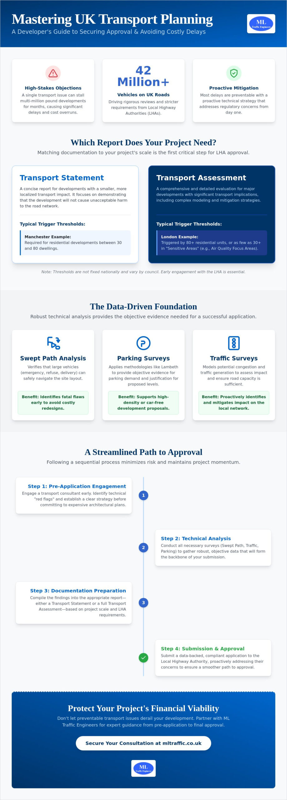
A single transport objection can stall a multi-million pound development for months; however, most delays are entirely preventable with a proactive technical strategy. With nearly 42 million vehicles now on UK roads, Local Highway Authorities are more rigorous than ever regarding site impact. You understand that managing these requirements is often the most volatile stage of the pre-construction process. Whether you are addressing the 2026 London Plan car-free mandates or trying to avoid the high costs of remedial design work, professional transport planning serves as your primary tool for risk mitigation. Precision at this stage doesn’t just satisfy regulators; it protects your project’s viability.
It’s frustrating when vague council feedback leads to expensive layout revisions. We agree that clear communication and data-backed submissions are the only ways to maintain project momentum and ensure safety. This article will help you master the complexities of the planning system to secure permission and optimize your project’s accessibility. We will preview the essential documentation you need, from Swept Path Analysis to Transport Assessments, and explain how to align your site with the latest 2026 regulatory benchmarks and National Planning Policy Framework standards.
Key Takeaways
- Determine the specific reporting thresholds for your development to accurately choose between a Transport Statement and a full Transport Assessment.
- Utilize precise technical data, including Swept Path Analysis, to build a transport planning strategy that proactively addresses Local Highway Authority safety concerns.
- Apply the Lambeth Methodology to parking surveys to provide the objective evidence needed to support high-density or car-free development proposals.
- Streamline your path to approval by mastering the sequential planning process from initial pre-application stages to final council submission.
- Secure a full-lifecycle partner to manage everything from onsite traffic surveys to regulatory reporting, ensuring technical consistency throughout your application.
What is Transport Planning in the Context of UK Development?
In the UK development sector, transport planning is a technical discipline that ensures new projects integrate safely into existing infrastructure. It isn’t just about drawing roads; it’s a multidisciplinary strategy that balances accessibility with public safety. In 2026, this process is governed by the National Planning Policy Framework (NPPF). This framework dictates how developers must manage the movement of people and goods while maintaining environmental standards and operational efficiency.
Transport is often the decisive factor in whether a local council grants planning permission. With nearly 42 million vehicles now on UK roads, the pressure on existing networks is immense. If a proposal fails to account for traffic volume or pedestrian safety, the Local Highway Authority (LHA) will likely object. Modern planning has shifted focus away from car-centric designs. Current policies prioritize sustainable travel by mandating car-free developments in areas with high public transport accessibility. This shift requires precise data to prove that a site can function without heavy car dependency.
To better understand the core components of this process, watch this helpful video:
The Core Objectives of a Transport Strategy
A robust transport strategy serves three primary functions. First, it ensures safe and suitable access for all road users, including vulnerable pedestrians and cyclists. Second, it identifies and mitigates any significant impacts on the local transport network. This often involves conducting detailed Traffic Surveys to model potential congestion and ensure road capacity. Finally, it promotes sustainable transport modes. By prioritizing walking and cycling infrastructure, developers align their projects with the government’s 2026 “Better Connected” strategy. This strategy aims for a more integrated, user-focused network across England.
When Should You Engage a Transport Consultant?
Engaging a consultant during the pre-application phase is a critical step for risk management. Early involvement allows you to identify technical “red flags” before they become expensive obstacles. For instance, initial Swept Path Analysis can determine if refuse or emergency vehicles can navigate your site layout. If the analysis shows a tight turn is impossible, you can adjust the design early without scrapping completed architectural drawings. Waiting until the full application stage to discover these issues leads to costly remedial design work and months of delays. Early transport planning ensures that site density and accessibility are optimized from day one, protecting your project’s financial viability and professional reputation.
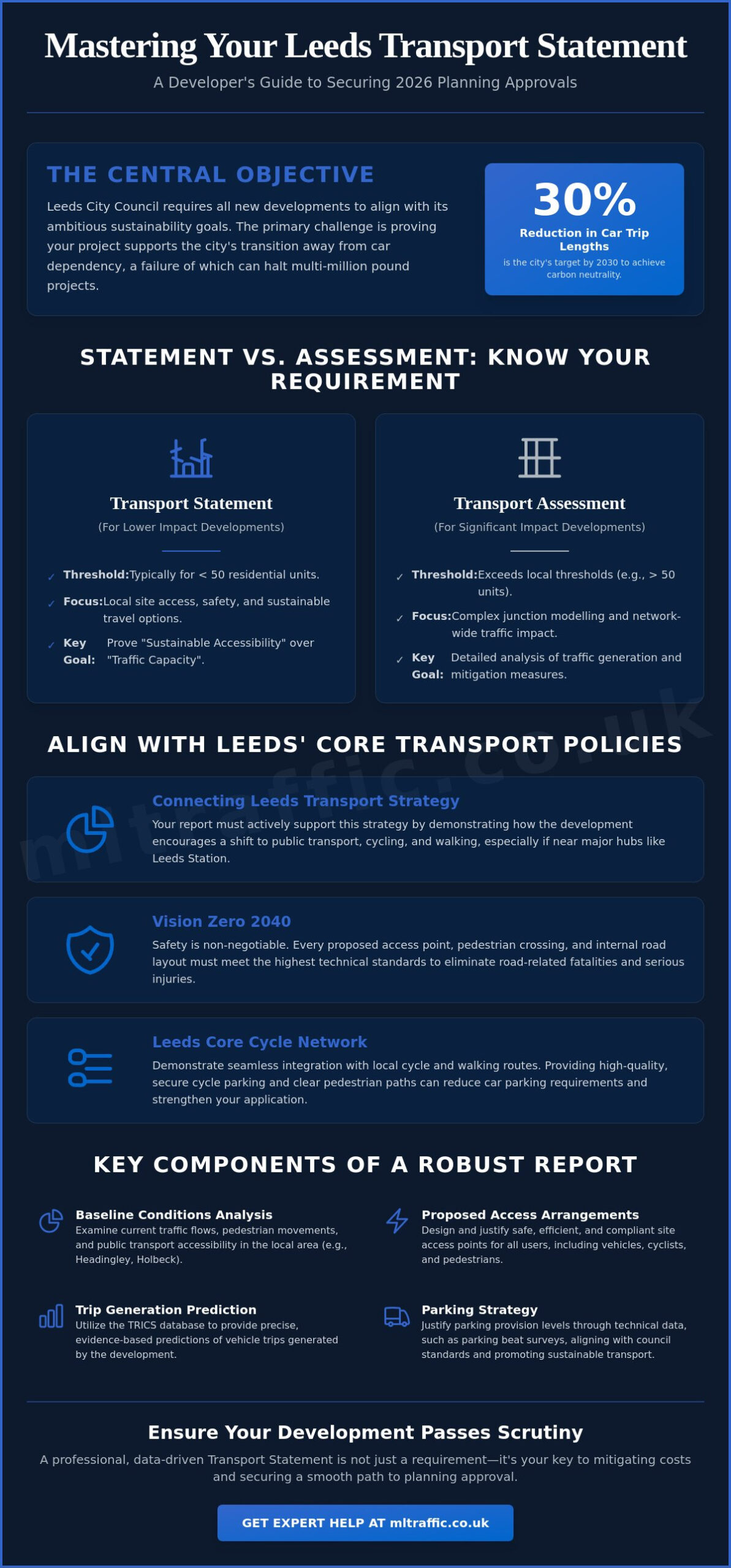
Key Documentation: Transport Statements vs. Transport Assessments
The hierarchy of documentation in transport planning is designed to match the scale of a project’s impact. Local Highway Authorities (LHAs) require different levels of technical evidence based on the size and location of a development. Outside of London, there are no fixed national thresholds for these reports. Developers must engage with local authorities early to confirm specific local requirements. However, in major hubs, the rules are more defined. For example, in Manchester, a Transport Statement is typically required for residential developments between 30 and 80 dwellings. In London, a full Transport Assessment is usually triggered by 80 or more residential units, though this can drop to 30 units in “Sensitive Areas” like Air Quality Focus Areas.
Predicting how many trips a new site will generate is a core requirement for both document types. We use the TRICS database to model these predictions for 2026. This data-driven approach aligns with the UK’s strategy for integrated transport, ensuring that new developments don’t overwhelm existing infrastructure. Precision here is non-negotiable. If your trip generation figures are inaccurate, the council may reject your entire application. Reviewing our project types can help you identify which document hierarchy fits your specific site layout.
Transport Statements for Smaller Developments
A Transport Statement is a concise report for projects with limited transport implications. It focuses on immediate site access and local safety. Typical triggers include proposals generating between 30 and 50 vehicle movements during peak hours. If you’re managing a minor residential scheme or a small commercial change, you’ll likely need a Transport Statement London: A Developer’s Buying Guide for 2026 to navigate these specific local requirements and avoid unnecessary delays.
Full Transport Assessments for Major Schemes
Major developments require a more rigorous technical analysis. A full Transport Assessment examines the wider impact on the road network, including detailed junction capacity modelling and multi-modal analysis. This document proves that the surrounding infrastructure can handle the increased load without compromising safety. You can find more details in our Transport Assessment London: The Developer’s 2026 Guide to Planning Success, which outlines how to manage these high-stakes submissions.
The Importance of Travel Plans
A Travel Plan is a long-term management strategy rather than a one-time assessment. It outlines how a development will encourage sustainable commuting patterns, such as cycling, walking, or car-sharing. Local authorities often secure these through planning conditions to meet regional environmental targets. Using expert Travel Plan Consultants ensures these strategies are both realistic for future residents and compliant with the latest 2026 standards.
Technical Analysis: Swept Path Analysis and Traffic Surveys
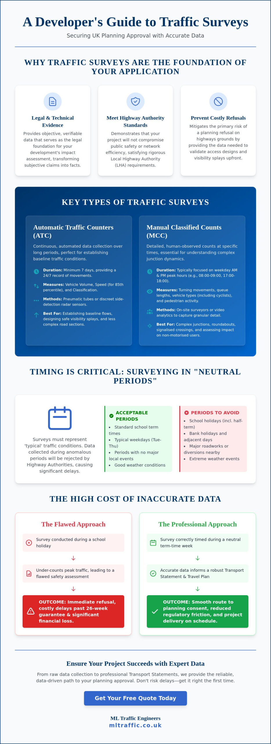
Raw technical data is the foundation of a successful planning submission. Without empirical evidence, a developer’s claims about site accessibility are merely anecdotal. For councils to approve a proposal, they require objective proof that the local infrastructure can absorb the new development’s impact. This evidence is gathered through specialized surveys and modeling software, which then populates the final Transport Statement or Assessment. This reliance on advanced data processing mirrors the digital transformation seen in other sectors, where specialists like Mkhaya MK leverage software engineering and AI-driven automation to turn complex information into actionable insights. In 2026, the demand for high-resolution data has never been higher, as Local Highway Authorities (LHAs) face increasing pressure to maintain road safety and network efficiency.
One critical tool in this process is the parking survey, often conducted using the Lambeth Methodology. This industry-standard approach measures “parking stress” by analyzing kerbside capacity within a 200-metre walking distance of the site. By identifying exactly how many spaces are available during peak hours, we provide the council with a clear picture of the local environment. This data is essential when proposing developments with limited on-site parking. It allows us to integrate technical findings directly into your transport planning strategy, defending your site layout against objections before they’re even raised.
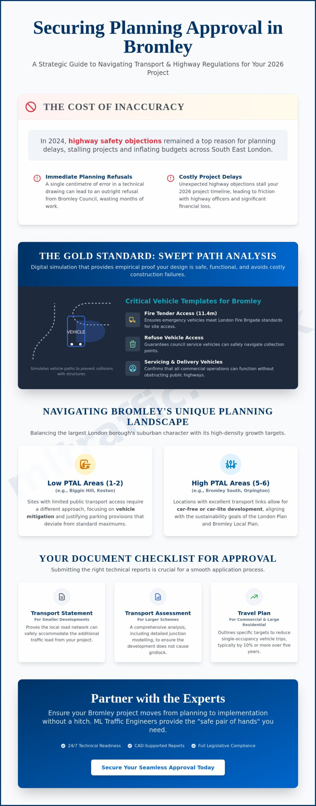
Visualising Access with Swept Path Analysis
Swept Path Analysis (SPA) is the digital simulation of vehicle movement. We use industry-standard software like AutoTURN to model the paths of fire tenders, refuse vehicles, and delivery vans. This process proves that large vehicles can enter, turn, and exit your site safely without mounting kerbs or striking buildings. Using AutoTURN Swept Path Analysis: A Practical Guide for Planning Applications helps you identify tight turns during the design phase. Spotting these issues early prevents the need for expensive architectural redesigns after you’ve already submitted your application. It’s a proactive step that ensures your site is operationally viable and safe for all users.
The Value of Accurate Traffic and Parking Surveys
Accurate traffic surveys provide real-time data on traffic flow and junction performance. In 2026, there’s a significant shift toward automated data collection methods, such as AI-powered cameras, which offer more reliable datasets than traditional manual counts. These surveys are vital for defending your project against council claims that the local network is at “over-capacity.” By citing the UK Government guidance on Local Transport Plans, we ensure that your data meets the statutory expectations for evidence-based decision-making. High-quality survey data doesn’t just support your application; it provides a factual shield against common planning objections and helps secure a smoother path to approval.
Navigating the Planning Process with Local Authorities
The journey from initial concept to planning approval is defined by the quality of your engagement with the Local Highway Authority (LHA). Successful transport planning requires a logical, sequential approach to satisfy strict regulatory benchmarks. This process begins long before a formal application is submitted. It involves technical negotiations that determine the financial and operational feasibility of your development. Managing these interactions with precision ensures that your project moves through the planning system without unnecessary friction.
Effective Pre-Application Engagement
Presenting a draft transport strategy during the pre-application phase allows you to agree on a “scope of works” with council officers early. This agreement is vital. It prevents you from wasting resources on redundant reports that the council may not require for your specific site. By building professional rapport with highway officers, you gain a clearer understanding of local priorities and potential “red flags.” This proactive engagement reduces the risk of unexpected objections later in the cycle and helps align your site layout with council expectations from day one.
Overcoming Common Transport Objections
LHAs frequently raise concerns regarding highway safety and increased congestion. These objections can stall a project if they aren’t addressed with technical authority. You must counter subjective concerns with the empirical evidence discussed in previous sections, such as Swept Path Analysis and real-time traffic data. If a council claims a junction is at capacity, your traffic surveys provide the factual basis to debunk that claim. Being proactive in your responses shows a commitment to professional integrity and public safety, which often smooths the path to a positive recommendation. To further refine your ability to influence and lead in these high-stakes environments, you can visit Toby and Kate McCartney for professional NLP certification and training.
Section 106 and Section 278 agreements are the primary legal mechanisms for infrastructure delivery in 2026. Section 106 involves planning obligations, such as financial contributions for new cycle paths or public transport improvements. Section 278 agreements are more technical; they permit developers to carry out works on the public highway, such as installing a new site entrance or modifying a junction. These agreements require careful negotiation to avoid project delays and spiraling costs. Precision in these legal documents is just as important as the technical data that supports them.
Public consultation provides a necessary platform to address community concerns before they escalate into formal planning objections. Local residents are often sensitive to changes in traffic volume and parking availability. By presenting the findings of your parking surveys and traffic modeling clearly, you can reassure the public that the development is safe and sustainable. This transparency builds trust and aligns with the high professional standards expected by local authorities across the UK. If you need technical support to navigate these council negotiations, view our full list of transport services to see how we can assist your project.
Choosing the Right Transport Planning Consultant in 2026
Selecting a consultancy is a strategic decision that directly affects your project’s timeline and budget. You need more than just a report writer; you need a partner who understands the high-stakes nature of infrastructure development. Effective transport planning requires a blend of advanced technical modeling and nuanced local knowledge. In a regulatory environment that’s constantly evolving, your consultant must provide more than just data. They must offer a factual shield that protects your project from objections and delays.
A full-lifecycle service is the most efficient way to manage this process. Fragmented services, where one firm handles surveys and another writes the report, often lead to data gaps and communication breakdowns. When a single team manages everything from onsite traffic surveys to the final Transport Assessment, technical integrity is maintained throughout. This continuity reduces regulatory pressure on your internal team and ensures that the data used in your submission is both accurate and defensible.
Expertise in Local Regulations
Every Local Highway Authority (LHA) has its own set of priorities and internal benchmarks. A consultant who understands the specific requirements of different London Boroughs will approach a project differently than one working with regional councils in Manchester or Bristol. This familiarity allows for smoother negotiations because the consultant speaks the “language” of the local highway officers. They know which technical arguments carry weight and which design features are likely to trigger an objection. You can explore our Project Types to see how we apply this industry-specific experience across various regional contexts.
The ML Traffic Advantage: Precision and Reliability
ML Traffic Engineers serves as a dependable, highly organized partner for developers across England. We take immense pride in our precision and adherence to industry standards. Our approach balances technical authority with a client-focused strategy, aiming to reduce the logistical burdens on your team. We manage the entire project lifecycle, providing essential deliverables like Swept Path Analysis, Parking Surveys, and support for Section 278 agreements. This comprehensive, fully-managed service is our hallmark.
Our commitment to safety and regulatory compliance is non-negotiable. We view our role as a vital guardian of public safety, ensuring that every development we support is accessible and safe for all users. By maintaining a standard of formal excellence, we align our work with the strict environments in which you operate. If you’re ready to secure your planning permission with a data-backed strategy, contact us today via our homepage to discuss your next project and request a tailored quote for your specific site requirements.
Secure Your Project’s Approval Through Technical Precision
Mastering the complexities of the planning system requires a shift from reactive design to proactive strategy. By correctly identifying the reporting thresholds for your site and deploying precise technical tools like Swept Path Analysis, you eliminate the risk of late-stage redesigns. Clear communication with Local Highway Authorities, backed by empirical data from traffic and parking surveys, remains the most effective way to overcome objections. Professional transport planning is the foundation of a successful, accessible development that meets modern sustainability standards.
ML Traffic Engineers was founded in 2014 and brings over a decade of planning success to your project. We’re specialists in Swept Path Analysis and Transport Statements, acting as expert navigators of UK Local Highway Authority requirements. Our team manages the full project lifecycle to ensure your submission meets every regulatory benchmark with total accuracy. We take pride in reducing the logistical pressures on our clients through unwavering reliability and technical authority.
Get an Expert Transport Planning Quote for Your Development. Your project deserves a partner who prioritizes precision and safety at every turn. We look forward to securing your project’s success.
Frequently Asked Questions
How much does a transport planning report cost in 2026?
Costs for these reports vary based on the project’s scale and the technical requirements of the Local Highway Authority. Minor residential schemes require less modeling than complex mixed-use developments that demand extensive junction analysis. You’ll need to request a tailored quote to ensure the fee reflects your site’s specific documentation needs. Factors like site location and the depth of required traffic data will influence the final investment.
Do I need a Transport Statement or a full Assessment for my project?
The requirement depends on the scale of your development and the volume of traffic it generates. Generally, smaller schemes producing between 30 and 50 vehicle movements during peak hours require a Transport Statement. Larger projects, such as those exceeding 80 residential units in most urban areas, typically trigger a full Transport Assessment. It’s vital to confirm these thresholds with your local council during the pre-application stage.
What is Swept Path Analysis and is it always required?
Swept Path Analysis is a digital simulation that proves vehicles can navigate your site layout safely. It’s almost always required for any development that involves new access points or internal roads. By modeling the movements of fire tenders and refuse trucks, you demonstrate that emergency and service vehicles can operate without hitting buildings or mounting kerbs. This technical evidence is a non-negotiable standard for most council approvals.
Can a Travel Plan help me get planning permission in a low PTAL area?
A robust Travel Plan acts as a management strategy to mitigate car dependency in areas with low public transport accessibility. It outlines specific measures to encourage sustainable travel, such as cycling facilities or car-sharing initiatives. By demonstrating a commitment to reducing single-occupancy vehicle trips, you align your project with regional environmental goals. This proactive approach can successfully address council concerns regarding increased traffic in less connected locations.
How long does it take to complete a traffic survey and report?
A standard survey and report typically take between two to four weeks to complete from the initial data collection. This timeline allows for onsite traffic counts, technical modeling, and the drafting of the final report. More complex projects requiring multi-day surveys or extensive junction modeling may require additional time. We prioritize efficient delivery to ensure your planning application stays on schedule without sacrificing technical precision.
What happens if the Local Highway Authority objects to my application?
If an objection is raised, you must provide technical evidence to address the council’s specific safety or capacity concerns. This often involves re-running Swept Path Analysis or providing more granular traffic data to debunk subjective objections. We act as your technical advocate during these negotiations. Our goal is to find design solutions that satisfy the authority while maintaining your project’s overall viability and density.
What is the TRICS database and why is it used in transport planning?
TRICS is the national standard system used to predict the number of trips a new development will generate. It uses data from thousands of existing sites across the UK to provide a reliable baseline for trip generation modeling. Using TRICS is a fundamental part of transport planning because it ensures your impact assessments are based on verified, real-world data. This consistency is essential for securing a positive recommendation from highway officers.
Do I need a consultant for a Section 278 agreement?
Engaging a consultant for a Section 278 agreement is essential because these legal contracts involve complex engineering and highway safety standards. A consultant ensures that any proposed works on the public highway meet the council’s strict technical specifications. This professional oversight prevents expensive delays during the construction phase. It also ensures that all legal and safety obligations are satisfied before the development is occupied or signed off.

Disclaimer
The content on mltraffic.co.uk, including all technical articles, guides, and resources, is provided for general informational and educational purposes only. It is not intended to constitute professional advice in traffic engineering, transportation planning, development approvals, or any other technical or legal field.
While ML Traffic Engineers makes every reasonable effort to ensure the accuracy, completeness, and timeliness of the information published, we do not provide any warranties or representations (express or implied) regarding its reliability, suitability, or availability for any particular purpose. Any reliance you place on the content is strictly at your own risk.
In no event shall ML Traffic Engineers, its directors, employees, authors, or affiliates be liable for any direct, indirect, incidental, special, consequential, or punitive damages (including, without limitation, loss of profits, data, or business opportunities) arising out of or in connection with the use of, or inability to use, any information provided on this website.
The articles and guides on this site are not a substitute for engaging a qualified, professional traffic engineer to assess your specific project requirements. For tailored advice, compliance assessments, or traffic engineering services, please contact a competent professional.
This disclaimer may be updated from time to time without notice. By accessing or using this website, you agree to be bound by the most current version of this disclaimer.