A place of worship doesn’t automatically need a full Transport Assessment. The requirement depends on the proposal’s scale and likely effects on the transport network. In London, strategically important developments that are legally referable to the Mayor should have one unless Transport for London agrees another approach in writing before the planning application. A transport assessment for a place of worship in Harrow may also be required for a non-referable application, and planning permission may be refused if transport impacts are severe.
It’s understandable to want a clear answer before preparing a planning application. The practical distinction is that a Transport Statement can be a shorter, simpler alternative when transport impacts are limited. A fuller assessment may be needed when the proposal could affect local journeys, parking or access.
This article explains what can trigger either document for a place of worship in Harrow and what to include in an initial scope. It also covers how to describe visitor movements, public transport, walking and cycling connections, parking, inclusive access and servicing, so the assessment reflects the site and its use.
Key Takeaways
- A full Transport Assessment isn’t automatic for a place of worship; the proposal’s scale and likely effects on local transport help determine the level of assessment needed.
- A Transport Statement may suit a proposal with limited transport impacts, while more complex effects may call for a fuller assessment.
- Build the scope around how people will arrive and move around the site, including walking, cycling, public transport and inclusive access.
- Consider parking, servicing and vehicle manoeuvres together so the assessment reflects how the site will operate during worship and other activities.
- A site location, intended use and approximate scale provide a practical starting point for defining the transport work required.
Cycle parking, servicing and inclusive access
For a place of worship in Harrow, parking provision depends on the proposal and site context, not the borough name alone. Review Harrow’s development plan alongside London Plan transport policies, then explain how visitors, staff and service vehicles will use the site.
Cycle and Car Parking Evidence
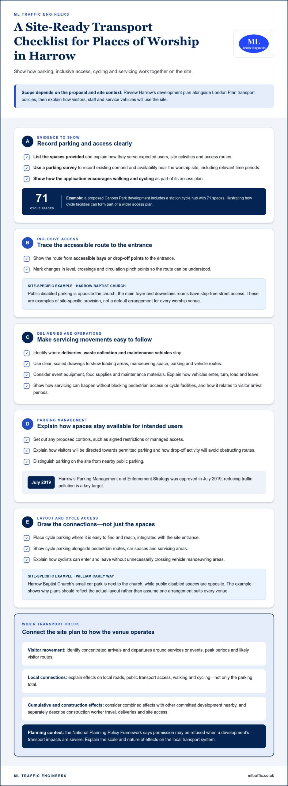
Cycle and car parking evidence records the spaces provided and how they serve expected users. It helps explain whether parking arrangements fit the site’s access, activities and surrounding routes. London planning applications must show how they encourage walking and cycling. A proposed Canons Park development includes a station cycle hub with 71 spaces, illustrating how cycle facilities can form part of a wider access plan. A parking survey can capture existing demand and availability near the worship site, including relevant time periods.
Accessible Parking and Drop-Off
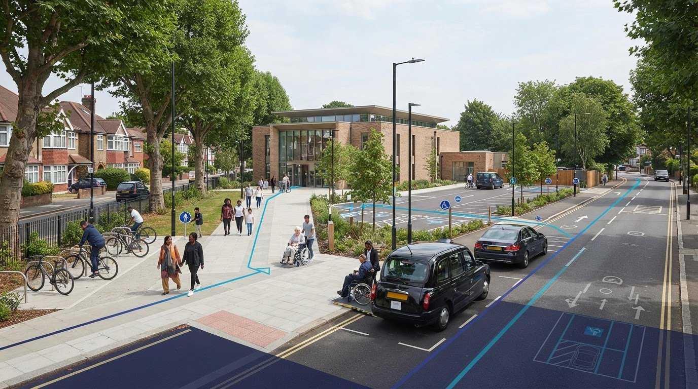
Accessible parking and drop-off arrangements show how people with mobility difficulties can reach the entrance. Harrow Baptist Church has public disabled parking opposite the church, and its main foyer and downstairs rooms have step-free street access. These are examples of site-specific provisions, not a default standard for every worship venue. Plans should show the route from accessible bays or drop-off points to entrances, including changes in level, crossings and circulation pinch points.
Loading and Servicing Arrangements
Servicing plans should identify where deliveries, waste collection and maintenance vehicles stop. Use clear, scaled drawings to show loading areas, manoeuvring space, parking and vehicle routes. Explain how each activity can take place without blocking pedestrian access or cycle facilities. For a worship site, consider event equipment, food supplies and maintenance materials. Make clear how vehicles enter, turn, load and leave, and how these movements relate to visitor arrival periods.
Parking Management and Enforcement
Parking management explains how spaces will be allocated and kept available for their intended users. Harrow’s Parking Management and Enforcement Strategy was approved in July 2019, and reducing traffic pollution is a key target. Set out any controls proposed for the site, such as signed restrictions or managed access. Explain how visitors will be directed towards permitted parking, and how drop-off activity will avoid obstructing routes. These details help distinguish site parking from nearby public parking.
Cycle Facilities and Site Layout
Cycle parking should be easy to find and reach, and integrated with the site entrance. Show its location alongside pedestrian routes, car spaces and servicing areas. A plan should explain how cyclists can enter and leave without unnecessarily crossing vehicle manoeuvring areas. Harrow Baptist Church’s small car park is next to the church in William Carey Way, while its public disabled spaces are opposite. This local example illustrates why drawings should show the actual layout rather than assume one arrangement suits every venue.
When is a transport assessment needed?
A proposal’s likely effect on local transport helps determine whether its planning application needs transport evidence. Common concerns include severe transport impacts, unclear access arrangements and inadequate consideration of effects on existing routes.
Planning and Local Transport Impacts
Transport impacts describe how a proposed use could change movement around its site. They matter because the National Planning Policy Framework says planning permission may be refused when a development’s transport impacts are severe. For a place of worship in Harrow, consider visitor arrivals, surrounding roads and pedestrian access together. Explain how the proposal could affect the local transport system.
Cumulative and Construction Impacts
Cumulative impacts are the combined effects of a proposal and other committed development nearby. Separate schemes may affect the same roads, junctions or walking routes. Construction creates a different set of movements, including worker travel, deliveries and site access. Describe how these activities could affect local movement during building work, rather than focusing only on the completed venue.
Assess how the proposal will actually operate. A worship venue may have concentrated arrivals and departures around services or events, unlike a use with steady daily visits. Identify peak periods and likely visitor routes. Explain the effects on local roads, public transport access, walking and cycling. This gives the planning authority a clearer picture than a parking total alone.
London policy context also matters. For Harrow, review the borough development plan alongside London Plan transport policies. The National Planning Policy Framework’s severe-impact test means it is important to explain the scale and nature of effects, not simply list them. If a proposal changes a venue’s use or extends it, set out how that could alter travel demand and access.
Consider construction impacts separately from the venue’s ongoing operation. Describe how construction vehicle access could interact with pedestrian routes and nearby activity. Identify any potential conflict between deliveries or site access and worship-related arrivals. Clear drawings and a concise account of vehicle movements can show how the construction phase relates to the surrounding transport network.
Equality considerations offer another useful planning perspective. Harrow’s Equality Impact Assessment considers how policies may affect different groups, including disabled or older residents. Apply that perspective when assessing whether people can reach the site and use its routes. Address access needs alongside general traffic effects, rather than treating visitor movement as a single, uniform pattern.
To frame the planning evidence, compare the proposed use, access and likely movement effects with the site’s surroundings. The London transport assessment guide provides a related overview of assessment considerations.
Vehicle movements and service-vehicle access
Assess how vehicles, pedestrians and public transport connect with the site. For a place of worship in Harrow, the assessment should reflect its actual location and periods of activity, not a borough-wide assumption.
Start with existing access conditions. Map the site entrance, nearby junctions, walking routes, crossings and public transport links. Record how visitors, staff and service vehicles currently arrive, then compare those patterns with the proposal. Whitchurch Lane provides a local example of parking controls affecting access: 69 on-street spaces have a single-yellow-line restriction from 8am to 6.30pm, Monday to Friday. Restrictions and their operating hours can influence where visitors stop or park.
Explain the proposed vehicle journeys from arrival to departure. Identify where service vehicles enter, stop, manoeuvre and turn, and how those movements relate to visitor access. Standard vehicle and load widths in the UK are 2.55 m, or 2.6 m for refrigerated units. These dimensions can inform access planning, but the assessment should reflect the vehicles expected to serve the particular site. Show any constrained entrances or turning areas on clear plans.
Public transport accessibility needs a site-specific review. Check relevant bus routes, operating hours and walking connections, then consider whether services align with worship times and events. A borough name alone doesn’t establish a site’s Public Transport Accessibility Level, or PTAL. The proposed Canons Park development has a PTAL score ranging from 4 to 6, but that example cannot determine the rating or parking needs of another Harrow site.
Walking and wheeled access should connect the surrounding routes with the entrance. Trace the approach from nearby stops, crossings and drop-off points, noting steps, narrow sections and points where people meet vehicle movements. The Mayor’s Transport Strategy aims for 80% of Londoners’ trips to be made by walking, cycling or public transport by 2041, according to Transport for London. TfL also recommends a night-time assessment in its Active Travel Zone assessment, relevant where worship or events finish after dark.
A Travel Plan can set out measures to support public transport access and reduce reliance on car journeys. Link each measure to the site’s actual routes and operating patterns instead of relying on generic commitments. For example, assess whether bus service hours align with evening events and whether the walk from stops is direct. Use this evidence to explain how people and vehicles move through the site without unnecessary conflict.
Information needed for an initial transport scope
Estimate attendance from the venue’s intended capacity, service schedule and expected event types. Then identify when visitors are likely to arrive and leave, including concentrated peaks around services or larger gatherings.
For an initial scope in Harrow, start with the site location, intended use and approximate scale. These establish the proposal’s basic transport context. Describe whether the venue is new, changing use or being extended, and outline its worship and community activities. Regular services and one-off events may create different travel patterns, so explain both where relevant.
Base the attendance estimate on how the venue will operate, rather than a generic figure. Consider usable capacity, the typical service timetable, the event calendar and expected attendance for each activity. Separate regular worship from occasional events, then describe likely arrival and departure periods. Explain the assumptions, including whether visitors are expected to arrive together or over a longer period.
- Site: identify its location, entrances and relationship to surrounding streets.
- Proposal: describe the intended use, approximate scale and planned changes.
- Activity: outline services, events and expected attendance patterns.
- Access: note nearby roads, bus routes, operating hours and walking connections.
Responsibilities can cross boundaries. For a Harrow site, the planning authority and the authority responsible for the road may differ. Identify both for the specific location, then consider which roads and junctions visitors would use. Review bus routes, operating hours and walking connections together. A nearby stop alone doesn’t show whether public transport suits the venue’s service times.
The need for formal transport evidence depends on the proposal’s likely effects. TfL uses national guidance from 2007 to help decide when Transport Assessments and Transport Statements are needed for different development types and sizes. In London, strategically important developments legally referable to the Mayor should have a Transport Assessment, unless TfL agrees another approach in writing before the planning application. Non-referable applications may also need one.
A Transport Statement is a shorter, simpler alternative for developments with limited transport impacts. A fuller Transport Assessment may be appropriate where the proposal could affect local roads, access or travel patterns more substantially. The National Planning Policy Framework says permission may be refused when transport impacts are severe. For Harrow proposals, consider the borough development plan alongside London Plan transport policies.
Use the initial details to define the scope, rather than assume a standard answer. Compare the proposed activity with existing site access and nearby transport conditions. If attendance peaks coincide with constrained access or limited public transport hours, assess those issues closely. This gives the planning submission a clear basis for explaining travel demand and the proposal’s effects.
When a Transport Assessment or Transport Statement is required
For Harrow applications, review the borough development plan alongside London Plan transport policies. The proposal’s scale and likely transport effects help determine whether a Transport Assessment or shorter Transport Statement is appropriate.
Transport Assessment and Statement Requirements
A Transport Assessment examines transport conditions and the likely effects of a proposal; a Transport Statement is a shorter alternative for limited impacts. This distinction helps applicants scope proportionate evidence. TfL uses national guidance from 2007 when considering requirements across development types and sizes. Strategic developments legally referable to the Mayor should have an assessment, unless TfL agrees another approach in writing before the planning application.
A non-referable London application may also require a Transport Assessment. For a place of worship, consider whether a new venue, extension or change of use could alter visitor journeys, access or local movement. Focus on how the proposed activity changes existing conditions. The decision isn’t based on the building’s label alone: anticipated transport implications matter.
Council Transport and Travel Plan Requirements
Assess Harrow’s transport requirements against its development plan and relevant London Plan policies. The borough name alone cannot establish a site’s PTAL or justify parking provision. A Travel Plan can describe measures that support public transport access and reduce car reliance. Its relevance depends on the proposal and the travel effects the application needs to address.
There isn’t one universal trigger that makes every place of worship require the same document. A Transport Statement can suit a proposal with limited transport impacts. A fuller assessment is more relevant when the proposed development could affect the surrounding transport system. The scope should reflect the development’s size and the extent of its likely effects.
Consider the proposal’s practical operation before selecting the evidence. A small change with little effect on visitor journeys may have different implications from an extension that increases attendance or changes access. Explain how people will arrive, walk to the entrance and leave. Include relevant public transport connections, parking demand and vehicle access where they help describe the likely effects.
For strategically important schemes, establish whether the application is legally referable to the Mayor. If it is, a Transport Assessment is expected unless TfL agrees another approach in writing before submission. Other London applications can still require an assessment. The National Planning Policy Framework also identifies severe transport impacts as a reason planning permission may be refused.
Define the evidence early by matching the proposal’s scale and transport implications to the appropriate document. The Transport Statement guide explains the shorter document’s role in planning applications.
ML Traffic Engineers UK: Transport Statements
ML Traffic Engineers UK prepares Transport Statements and Transport Assessments for planning applications. For a place of worship in Harrow, these documents can explain expected travel patterns, site access and a proposal’s likely transport effects. A Transport Statement may suit limited impacts, while a Transport Assessment provides more detailed analysis where needed.
Where parking demand needs evidence, Parking Surveys can describe existing conditions. Swept Path Analysis can show whether relevant vehicles can manoeuvre within the proposed layout. These services connect the planning question with practical details of access and movement.
Contact ML Traffic Engineers UK or visit mltraffic.co.uk to discuss transport evidence for your proposed development.
Set a Clear Direction for Your Planning Application
The next step is to turn the site proposal into a focused transport brief. Clarify the intended use, operating pattern and key access questions before deciding what evidence will support the planning application. A transport assessment for a place of worship in Harrow should respond to the specific proposal, not rely on a generic template.
ML Traffic Engineers UK can develop that evidence through Parking Surveys, Transport Statements and Swept Path Analysis. These services address different planning questions, from understanding parking conditions to documenting vehicle manoeuvres. The appropriate scope depends on what the application needs to demonstrate.
Bring together the site location, proposed use and approximate scale to start a focused discussion. This gives the assessment a practical foundation and helps identify which transport issues need attention first.
Contact ML Traffic Engineers UK to discuss the transport evidence for your proposal. A clear scope is a constructive next step towards a well-supported planning application.
Frequently Asked Questions
Why do a TA?
A Transport Assessment gives the planning authority a reasoned account of how a proposal may affect travel. It connects expected visitor activity with local transport conditions and explains the basis for the planning decision. For example, a venue hosting simultaneous community events may create different arrival patterns from one serving a single regular congregation. Setting out these operational details makes the transport case clearer and helps identify issues that need further analysis.
What is a transport assessment for a place of worship in Harrow?
A transport assessment for a place of worship in Harrow is a technical planning document that examines transport conditions and the likely effects of a proposed development. It considers how the venue’s use relates to journeys, access and the surrounding transport network. Its scope reflects the proposal, not just the building type. It can explain how the site will function for visitors, staff and deliveries in its specific Harrow location.
When is a transport assessment required for a place of worship planning application in Harrow?
A Transport Assessment may be needed when a proposal could affect the local transport system, while a Transport Statement may suit limited effects. In London, strategically important developments legally referable to the Mayor should have an assessment unless TfL agrees another approach in writing before application. Non-referable applications may also need one. The proposal’s scale and likely transport implications guide the scope, rather than a universal rule for every place of worship.
What traffic, parking and accessibility surveys are needed for a place of worship in Harrow?
Survey requirements depend on the transport question the application needs to answer. Traffic Surveys can establish movement patterns on relevant roads, while Parking Surveys can record how nearby spaces are used. Accessibility evidence should examine routes between the site, public transport stops and entrances, including barriers for people with mobility needs. A venue with concentrated event arrivals may need evidence focused on those periods, rather than information that misses its busiest activity.
How are public transport, walking and cycling access assessed for a Harrow place of worship?
Assess the complete journey between transport connections and the venue, not just the distance to a stop. For example, check whether a bus serves the area during evening worship and whether the walking route provides a continuous, usable connection to the entrance. Cycling access should consider how riders reach cycle parking and avoid conflict with vehicle movements. A site’s PTAL must reflect its location; Harrow as a borough doesn’t determine it.
What planning policies and national guidance govern transport assessments in Harrow?
Harrow proposals should be considered against the borough development plan and London Plan transport policies, alongside the National Planning Policy Framework. The Framework says planning permission may be refused where transport impacts are severe. TfL uses national guidance from 2007 to help determine when assessments and statements are needed. Together, these sources provide the planning context; the proposal’s location, scale and likely effects shape how that context applies.
What parking standards apply to places of worship in Harrow?
Parking provision depends on the proposal and site context, not the borough name alone. Review Harrow’s development plan alongside London Plan transport policies, and use a parking survey to assess existing demand and availability near the site.

Disclaimer
The content on mltraffic.co.uk, including all technical articles, guides, and resources, is provided for general informational and educational purposes only. It is not intended to constitute professional advice in traffic engineering, transportation planning, development approvals, or any other technical or legal field.
While ML Traffic Engineers makes every reasonable effort to ensure the accuracy, completeness, and timeliness of the information published, we do not provide any warranties or representations (express or implied) regarding its reliability, suitability, or availability for any particular purpose. Any reliance you place on the content is strictly at your own risk.
In no event shall ML Traffic Engineers, its directors, employees, authors, or affiliates be liable for any direct, indirect, incidental, special, consequential, or punitive damages (including, without limitation, loss of profits, data, or business opportunities) arising out of or in connection with the use of, or inability to use, any information provided on this website.
The articles and guides on this site are not a substitute for engaging a qualified, professional traffic engineer to assess your specific project requirements. For tailored advice, compliance assessments, or traffic engineering services, please contact a competent professional.
This disclaimer may be updated from time to time without notice. By accessing or using this website, you agree to be bound by the most current version of this disclaimer.