Tag: Lambeth Council

  • Lambeth Council Parking Survey Requirements: A 2026 Developer’s Guide

    Lambeth Council Parking Survey Requirements: A 2026 Developer’s Guide

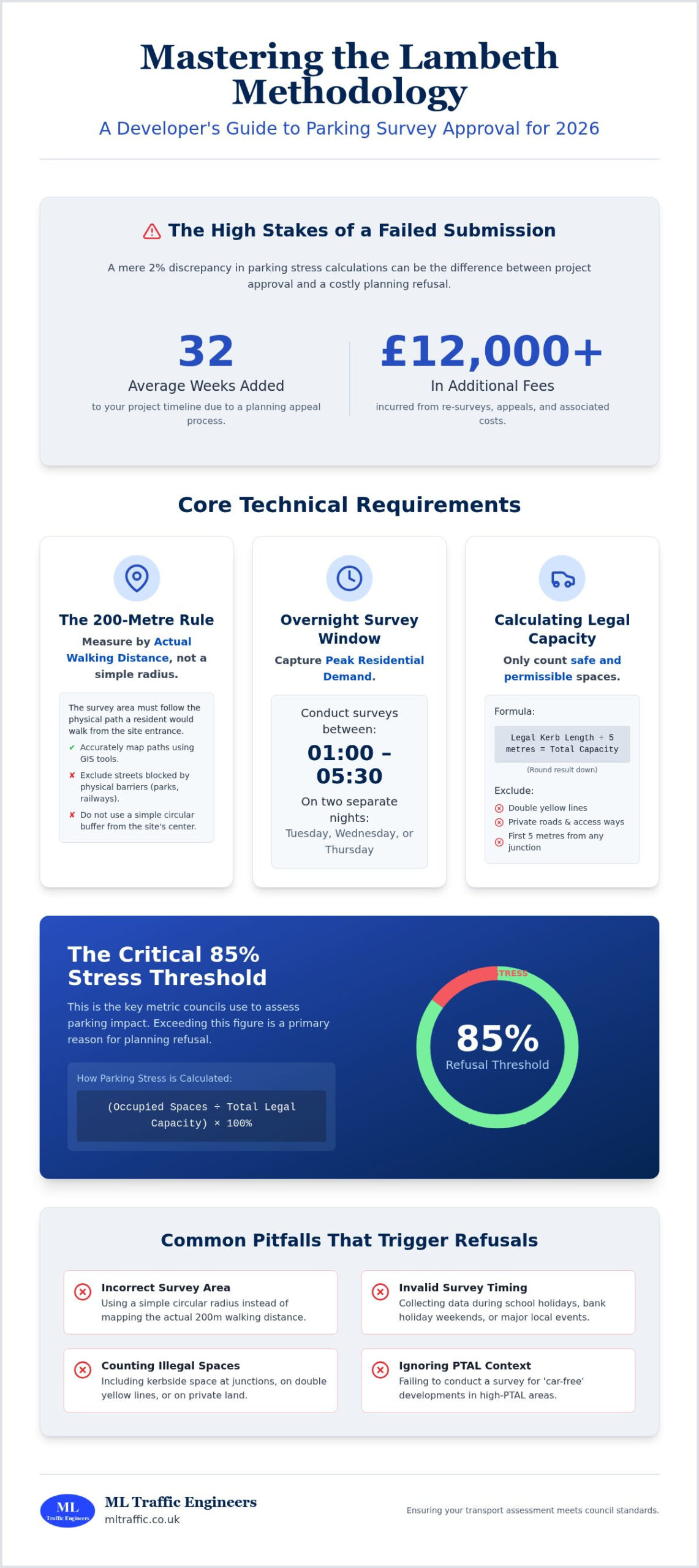
    Did you know that a mere 2% discrepancy in parking stress calculations is often the difference between a project’s green light and a costly planning refusal? For developers in 2026, the pressure to deliver accurate data is immense. You already know that securing a transport assessment for residential development UK projects involves more than just counting cars; it’s about navigating a rigid regulatory framework where one misstep can stall your timeline for months. A failed submission doesn’t just delay construction; it can trigger a planning appeal process that adds an average of 32 weeks to your schedule and costs upwards of £12,000 in additional fees.

    ML Traffic Engineers UK provides this guide to help you master the technical specifications of the Lambeth Methodology. We ensure your parking survey meets council standards to secure planning approval without the risk of expensive re-surveys. We’ll break down the essential 200-metre walking distance rule, the precise 01:00 to 05:30 survey window, and the specific strategies required to handle high-PTAL parking restrictions effectively. By the end of this article, you’ll have a clear roadmap for producing a planning-ready report that stands up to the highest levels of council scrutiny.

    Key Takeaways

    • Understand why the Lambeth Methodology is the industry standard for parking stress analysis and how it differs from national guidance.
    • Learn how to integrate precise survey data into a robust transport assessment for residential development UK projects to meet 2026 council standards.
    • Master the 200-metre walking distance rule to ensure your survey area captures accurate data from the site entrance instead of using incorrect measurements.
    • Identify the critical 85% parking stress threshold to proactively address potential planning refusals before they delay your project timeline.
    • Avoid costly re-surveys by adhering to strict overnight timing requirements and correctly excluding non-compliant kerbside spaces like junctions.

    What is the Lambeth Methodology for Parking Surveys?

    The Lambeth Methodology is a rigorous technical protocol designed to measure on-street parking stress within high-density urban environments. While national frameworks like the New Approach to Appraisal (NATA) provide a macro-level view of transport project value, Lambeth’s specific standards address the micro-level reality of kerbside management. This methodology has become the definitive benchmark across South London because it provides a repeatable, transparent way to quantify how much space is actually left on the street at night. For any transport assessment for residential development UK planning officers review, this data serves as the primary evidence regarding local highway capacity.

    The Origins and Purpose of the Standard

    Lambeth established these requirements to mitigate the friction between new development and existing residential amenity. In a borough where kerbside space is a finite and over-subscribed resource, the council cannot rely on generic national guidance that might suit a rural town or the different requirements of the Kent (KCC) standards. The methodology is legally anchored in the Lambeth Local Plan 2026 and the associated Supplementary Planning Document (SPD). Its purpose is to ensure that proposed developments don’t compromise public safety or block emergency vehicle access due to excessive overspill parking. It creates a level playing field where developers and council officers work from the same set of verified facts.

    When is a Lambeth Parking Survey Mandatory?

    You’ll typically need to commission a survey for any project that could increase parking demand. This includes residential conversions of single dwellings into multiple flats, large-scale new-builds, and ‘Prior Approval’ applications for commercial-to-residential changes. Your site’s Public Transport Accessibility Level (PTAL) score is a major factor here. Even for car-free developments in high-PTAL areas, a survey is often required to prove that visitors or residents with disabled permits won’t overwhelm the surrounding streets. At ML Traffic Engineers UK, we integrate these surveys directly into the wider transport assessment for residential development UK requirements to streamline the approval process and reduce the risk of planning delays.

    Technical Requirements: The 200-Metre Radius and Timing

    Precision is the primary requirement for any parking data submission in 2026. When preparing a transport assessment for residential development UK planning teams will scrutinize the application of the Lambeth Methodology. The core technical requirement is a 200-metre walking distance survey area. This isn’t a simple circular buffer drawn on a map. It must reflect the actual route a resident would walk from the site entrance to find an available kerbside space. This local rigor aligns with the broader UK Government guidance on Transport Assessments, which emphasizes that all evidence must be robust, current, and proportionate to the development’s scale.

    Mapping the Survey Area Correctly

    Accuracy starts with professional GIS tools. We map the 200m walking route, which typically results in an irregular shape rather than a perfect circle. Physical barriers such as railway lines, parks, or the River Thames must be accounted for. If a resident cannot physically walk to a street within the 200m limit, that street is excluded from the capacity count. You must also identify specific exclusion zones. Double yellow lines, private roads, and the first 5 metres of kerb space from any junction cannot be counted. We calculate the total capacity by dividing the remaining unrestricted kerbside length by 5 metres per vehicle and rounding down. This ensures the data reflects only safe and legal parking options.

    Optimal Survey Timing and Seasonal Factors

    The timing of the data collection is just as critical as the geography. Surveys must be conducted between 00:30 and 05:30 to capture peak residential parking demand. This window ensures that daytime commercial activity or transient traffic doesn’t skew the results. Lambeth requires this data from two separate weeknights, typically a combination of Tuesday, Wednesday, or Thursday. These nights represent neutral traffic conditions. Data collected during school holidays, bank holiday weekends, or major local events like Brixton concerts will likely face rejection. For a Lambeth residential application, the ideal survey window is a two-night overnight snapshot between 00:30 and 05:30 on consecutive neutral weekdays. If you’re unsure about the local event calendar, consulting with a technical expert can prevent the high costs of re-conducting surveys.

    Calculating Parking Stress and Impact Assessment

    The calculation phase transforms raw street data into a technical argument for development. The standard formula compares the number of parked vehicles to the total available kerbside capacity. For a transport assessment for residential development UK, we calculate this as a percentage for every street segment within your surveyed area. We determine capacity by measuring unrestricted kerb lengths, subtracting safety clearances at junctions, and dividing by a standard 5-metre vehicle length. This provides the council with a clear baseline of existing occupancy levels before your project begins.

    The 85% occupancy rate is the specific threshold where Lambeth considers a street to be at capacity. Once stress levels reach this point, a street is considered full; any additional parking demand is likely to cause residents to double-park or obstruct driveways. If your survey shows existing stress is already near or above this level, your impact assessment must demonstrate exactly how many additional vehicles your project will generate. We calculate this potential overspill by assessing the proposed unit mix and comparing it to the parking spaces provided on-site.

    Interpreting the 85% Capacity Benchmark

    When stress levels exceed the 85% benchmark, ML Traffic Engineers UK works with developers to implement effective mitigation strategies. For sites with high PTAL scores of 4 or above, justifying a car-free development is the most common solution. This involves a legal agreement that prevents new residents from obtaining local parking permits. This approach aligns with the Lambeth Methodology for Parking Surveys and effectively decouples the new development from the local kerbside demand. This allows projects to proceed even in highly congested Controlled Parking Zones (CPZs).

    Data Presentation for Planning Officers

    A successful transport assessment for residential development UK relies on transparent data presentation. We provide planning officers with timestamped photographic evidence for each street, alongside detailed logs that track occupancy across both survey nights. Our reports feature colour-coded mapping to highlight streets with remaining capacity versus those at the 85% limit. For more details on integrating these findings into a major site strategy, you can review our guide to Transport Assessment London. This level of detail ensures your submission meets the council’s requirement for independent verification.

    Common Pitfalls in Lambeth Planning Submissions

    Planning rejections in 2026 often stem from technical oversights that developers overlook during the initial data collection phase. A robust transport assessment for residential development UK planning officers evaluate must be free from methodological errors to avoid the high costs of re-submission. The most frequent failure is the application of incorrect survey boundaries. While a simple circular radius is easier to map, it doesn’t reflect how residents actually move through the urban environment.

    The “Crow Flies” vs. Walking Distance Error

    Lambeth strictly requires a 200-metre walking distance from the site entrance, not a radial “as the crow flies” buffer. This distinction is critical because physical barriers like fences, railway lines, or one-way systems significantly alter the actual walking route. Using a circular buffer often includes streets that are inaccessible to residents, leading to an automatic “Invalid” status for your transport report. In one documented instance, a residential development faced rejection because a 15-metre radius discrepancy incorrectly included a street blocked by a physical barrier. We use precise mapping tools to ensure every metre of the survey boundary is legally and physically accessible.

    Inadequate Data and Timing Errors

    Another pitfall involves failing to provide granular data on Controlled Parking Zone (CPZ) hours and permit eligibility. You must account for “Permit Voids,” which represent the difference between the number of permits issued and the actual kerbside capacity. If permit uptake is already high, the council may view any additional demand as an unacceptable risk. Timing is also non-negotiable. Surveys conducted during August or December are considered “non-neutral” due to holiday traffic patterns. If your data isn’t collected during a typical school term week, it will likely be discarded during the technical review.

    Managing Resident Objections and Consultation

    Professional parking data serves as a technical shield during the public consultation phase. Local residents frequently object to new developments based on the subjective belief that there is “no parking space” available. Objective, timestamped survey data allows you to counter these claims with verifiable facts. By integrating these results into a comprehensive Transport Statement, you provide planning officers with the evidence needed to override anecdotal complaints. If you want to ensure your data is beyond reproach, book a professional parking survey to secure your project’s timeline.
    Lambeth Council Parking Survey Requirements: A 2026 Developer’s Guide

    Securing Approval with ML Traffic Engineers

    Success in 2026 requires more than just raw data. Our specialized approach to Lambeth Council’s technical requirements ensures that every transport assessment for residential development UK planning teams review is both robust and compliant. We manage the entire project lifecycle, from the initial overnight data collection to the final integration of results into your planning submission. By acting as your technical liaison with Lambeth Highways officers, we reduce the regulatory pressure on your team and provide clear, evidence-based responses to any council queries.

    Precision in Swept Path Analysis is a vital complement to your parking survey. While the survey proves there’s enough space on the street, swept path analysis demonstrates that vehicles can safely enter and exit your site without creating a hazard. This dual-focus approach is essential for modern residential developments where every square metre of land is utilized. We ensure that your car park layout is not only efficient but also meets the strict safety standards required for planning approval.

    Our Full-Lifecycle Support for Developers

    Our work begins with an initial feasibility check to determine if a survey is strictly necessary for your specific site. This prevents unnecessary expenditure and ensures you only commission the services required to satisfy council conditions. When parking stress is high, we seamlessly integrate your survey data with comprehensive Travel Plans. These plans act as a mitigation strategy, demonstrating to the council how your development will encourage sustainable transport and reduce the overall demand for on-street parking. We take pride in our role as a technical guardian, ensuring your project meets industry benchmarks at every stage.

    Ready to Start Your Lambeth Project?

    Early engagement is the most effective way to avoid project timeline drift. Waiting until the final stages of a planning application to commission a survey can lead to significant delays, especially if the initial data shows high stress levels that require mitigation. We recommend requesting a technical review of your site access and car park layout as early as possible. This proactive step allows us to identify and resolve potential issues before they become obstacles to approval. To secure your 2026 project timeline, you can contact ML Traffic Engineers UK for a Lambeth-compliant parking survey quote today. Our team is ready to provide the unwavering reliability your development requires.

    Master Your 2026 Planning Submission

    Achieving planning approval in Lambeth requires absolute adherence to technical standards. You must prioritize the 200-metre walking distance rule and ensure your data collection occurs within the mandatory overnight window. Precision in these areas prevents the small calculation discrepancies that frequently lead to automatic rejections. Integrating these verified results into a comprehensive transport assessment for residential development UK projects is the most reliable way to mitigate council concerns regarding overspill parking.

    ML Traffic Engineers provides over 35 years of traffic engineering expertise to act as your technical guardian. We specialize in the specific planning requirements of the London Borough of Lambeth, delivering fully managed technical reporting that stands up to officer scrutiny. Our team understands the high-stakes nature of your project and remains ready to provide the accuracy your submission demands. We focus on the regulatory details so you can focus on the build.

    Secure your Lambeth planning approval with expert parking surveys from ML Traffic Engineers. Your project’s success depends on data that council officers can trust; we’re here to provide that foundation.

    Frequently Asked Questions

    Is the Lambeth Methodology different from the KCC (Kent) parking standards?

    The Lambeth Methodology is distinct from KCC standards. While Kent guidance often focuses on parking ratios for suburban sites, Lambeth requires a technical stress analysis based on a 200-metre walking distance. This methodology is specifically designed for high-density London environments. It focuses on the actual occupancy of the kerbside between 01:00 and 05:30, providing a data-driven snapshot that KCC’s general parking standards don’t typically demand.

    How many nights of data are required for a Lambeth parking survey in 2026?

    Two separate neutral weeknights are mandatory for a compliant report. You must conduct surveys on Tuesday and Wednesday or Wednesday and Thursday nights. This ensures the data captures a typical residential peak without the influence of weekend travel or local Sunday markets. In 2026, Lambeth planning officers continue to reject applications that rely on single-night snapshots or data collected during non-neutral periods like school holidays.

    Can I conduct my own parking survey for a small residential planning application?

    You can’t conduct your own survey for a planning application. Council officers require reports from independent specialists to ensure data integrity and methodological compliance. A professional report includes raw data logs, scaled mapping, and photographic evidence for every street surveyed. Attempting a DIY survey often leads to an automatic “Invalid” status for your transport assessment for residential development UK, causing significant project delays and potential re-survey costs.

    What happens if the parking stress in my area is already over 85%?

    When stress exceeds 85%, the local streets are considered effectively full. You’ll need to propose robust mitigation to secure planning approval. Common strategies include entering a “permit-free” legal agreement, which prevents future residents from obtaining on-street parking permits. You might also provide on-site car club bays or improve local cycling infrastructure. These measures prove that your development won’t cause unacceptable overspill parking on already congested roads.

    Do I need a parking survey for a “car-free” development in Lambeth?

    You still need a parking survey for a car-free development in Lambeth. The council must verify that potential visitor parking or residents with special permit eligibility won’t push the local network beyond its capacity. The survey provides the evidence base to justify the car-free status. It demonstrates that any minor increase in kerbside demand can be absorbed safely without compromising highway safety or residential amenity.

    How long is a parking survey valid for Lambeth planning purposes?

    A parking survey is valid for 6 months from the date of the final site visit. If your application submission falls outside this window, the council will likely require a fresh set of data to account for changes in local parking patterns. It’s vital to coordinate your survey timing with your overall planning schedule to avoid the logistical pressure and cost of re-conducting the work.

    Does the 200m radius include parking spaces in neighbouring boroughs like Southwark?

    The 200m radius is based on actual walking distance from the site entrance and ignores borough boundaries. If your survey area extends into Southwark or Wandsworth, you must include those streets in your data collection. You’ll need to account for the specific Controlled Parking Zone (CPZ) hours and restrictions of the neighbouring borough. This ensures the impact assessment is technically complete and reflects real-world parking behavior.

    What specific vehicle templates should be used for swept path analysis alongside the survey?

    Swept path analysis should utilize standard vehicle templates like the 4.7m Large Car and the 11.4m Refuse Collection Vehicle (RCV). For residential sites, fire tender access templates are also a non-negotiable requirement. Using these precise dimensions demonstrates that vehicles can safely manoeuvre within your site and the surrounding streets. This technical analysis complements your parking survey by proving that the proposed access is functional and safe.

    Michael Lee

    Article by

    Michael Lee

    Transport planner with over 35 years' experience.

    Disclaimer

    The content on mltraffic.co.uk, including all technical articles, guides, and resources, is provided for general informational and educational purposes only. It is not intended to constitute professional advice in traffic engineering, transportation planning, development approvals, or any other technical or legal field.
    While ML Traffic Engineers makes every reasonable effort to ensure the accuracy, completeness, and timeliness of the information published, we do not provide any warranties or representations (express or implied) regarding its reliability, suitability, or availability for any particular purpose. Any reliance you place on the content is strictly at your own risk.
    In no event shall ML Traffic Engineers, its directors, employees, authors, or affiliates be liable for any direct, indirect, incidental, special, consequential, or punitive damages (including, without limitation, loss of profits, data, or business opportunities) arising out of or in connection with the use of, or inability to use, any information provided on this website.
    The articles and guides on this site are not a substitute for engaging a qualified, professional traffic engineer to assess your specific project requirements. For tailored advice, compliance assessments, or traffic engineering services, please contact a competent professional.
    This disclaimer may be updated from time to time without notice. By accessing or using this website, you agree to be bound by the most current version of this disclaimer.

  • Lambeth Parking Survey Methodology: The 2026 Developer’s Guide to Planning Approval

    Lambeth Parking Survey Methodology: The 2026 Developer’s Guide to Planning Approval

    Your 2026 London development project could face an immediate planning refusal because of a single data error recorded at 02:00. Securing planning permission in Lambeth requires more than just a standard traffic count; it demands strict adherence to the lambeth parking survey methodology. We understand that the pressure to prove parking stress levels are manageable is immense, especially when a single mistake during the 01:00 to 05:30 observation window can invalidate your entire application.

    You’re likely concerned about the precision needed for 200-metre walking distance calculations or how to justify a car-free development to a sceptical Case Officer. It’s a common frustration for developers who want to keep their project on track. This guide provides the technical clarity you need to master these requirements and submit a compliant report. We’ll examine the exact data collection standards and show you how to leverage 24/7 expert monitoring to ensure your project moves from the planning phase to final implementation without a hitch.

    Key Takeaways

    • Understand why this technical framework is the industry-standard requirement for securing planning permission across London’s most competitive boroughs.
    • Master the mandatory survey parameters, including the strict 200-metre walking distance radius and the non-negotiable 01:00 to 05:30 observation window.
    • Learn how to apply the lambeth parking survey methodology to calculate parking stress and successfully navigate the critical 80% capacity threshold.
    • Identify borough-specific variations in Southwark, Wandsworth, and Lewisham to ensure your technical submission meets local regulatory expectations.
    • Discover why professional data collection is essential to provide the accuracy required to prevent planning refusals and costly project appeals.

    Table of Contents

    What is the Lambeth Parking Survey Methodology?

    The lambeth parking survey methodology represents the benchmark for quantifying on-street parking capacity across the capital. While originally developed by Lambeth Council, it has since become the industry-standard framework adopted by the majority of London boroughs. It functions as the primary evidence-based tool for developers to prove that a new project won’t cause unacceptable parking pressure on local residents. This rigorous assessment is a non-negotiable requirement for any project where the proposed parking provision falls below local authority standards. It ensures that the Technical aspects of urban planning are balanced with the practical realities of street-level infrastructure.

    For developers in 2026, precision is vital. Planning committees don’t accept guesswork. They demand empirical data. The methodology provides a clear, mathematical snapshot of how many cars are parked within a specific radius of a site. It’s the foundation of a successful planning application, especially for high-density residential schemes. Without this data, your project risks immediate rejection on the grounds of transport impact. We provide the technical expertise to ensure your survey meets these exacting standards from the first day.

    To better understand the practical side of parking management in the borough, watch this helpful video from Lambeth Council:

    The Core Purpose of the Survey

    The methodology’s main goal is to establish a baseline of existing parking demand during peak residential times. This usually involves two separate counts between 12:30 am and 5:30 am on weekday nights. These specific hours capture the maximum number of residents at home. The data provides the empirical evidence needed to support car-free or car-capped developments. It directly satisfies the requirements of the National Planning Policy Framework (NPPF), which states that development should only be refused on highways grounds if there’s an unacceptable impact on safety or a residual cumulative impact. By using the lambeth parking survey methodology, you provide the clear evidence needed to mitigate these concerns.

    Why ‘Lambeth’ is the London Standard

    Consistency across different local authorities is the main reason this methodology dominates the market. It prevents methodology hopping, where developers might try to use less rigorous standards to hide parking issues. For Planning Committees, it offers a transparent and repeatable metric that they can trust. This level of standardisation simplifies the approval process. The survey results integrate naturally with Transport Statements and Assessments, forming a cohesive argument for your site’s viability. It’s a reliable system that allows us to manage your project’s regulatory burdens with total precision.

    The Technical Framework: Radius, Timing, and Capacity

    Precision is the foundation of the lambeth parking survey methodology. It’s not a simple tally of vehicles; it’s a rigorous technical assessment where accuracy determines the success of a planning application. Developers must provide a granular view of local parking stress to satisfy Council requirements and avoid costly delays. This starts with a clear understanding of the spatial and temporal boundaries that define the survey’s scope.

    Mapping the 200m Survey Area

    The survey doesn’t use a simple radial “as the crow flies” circle. Instead, it requires a true 200-metre walking distance route from the site entrance. Our team utilizes 1:1250 scale OS mapping to identify every available centimetre of kerbside space within this walkable network. We account for physical obstructions that reduce capacity, including fire hydrants, private driveways, and dropped kerbs. This level of detail is critical because the Planning Inspectorate Appeal Decision has demonstrated that even minor inaccuracies in survey boundaries can undermine a developer’s transport statement. We exclude areas where parking is prohibited, such as double yellow lines or within 10 metres of a junction, to ensure the data reflects legal, safe parking only.

    Standardising the Survey Times

    Data collection must occur during the period of maximum residential parking demand. The non-negotiable window is 01:00 to 05:30. Surveys are conducted on two separate weekday nights, typically a Tuesday and a Wednesday, to provide a representative average of typical parking stress. We strictly avoid anomalous dates. This includes bank holidays, school half-terms, or nights where major local events at venues like the Brixton Academy might skew the results. Our safety-conscious data collectors work through these 24/7 environments in high-visibility gear, capturing snapshots of every parked vehicle to calculate exact occupancy rates. This high-stakes environment demands the unwavering reliability that our field teams provide.

    Calculating Theoretical Capacity

    On unmarked roads, we apply the 5-metre rule. This standard dictates that each 5-metre length of clear kerbside constitutes one parking space. We then cross-reference this against Controlled Parking Zones (CPZs) and specific permit restrictions to determine the true capacity available to residents. For developments with tight access points, we often pair these surveys with Swept Path Analysis services to prove that increased parking occupancy won’t compromise emergency vehicle access or general highway safety. If you’re preparing a submission for a high-density project, our team offers comprehensive support to ensure your data meets the 2026 standard for planning approval.

    Lambeth Parking Survey Methodology: The 2026 Developer’s Guide to Planning Approval

    Calculating Parking Stress and Impact on Planning

    Accurate data interpretation is the backbone of any successful planning application in South London. Under the lambeth parking survey methodology, parking stress is defined as the percentage of kerbside capacity occupied by vehicles at peak times. This figure determines whether your project adds unacceptable pressure to local infrastructure or remains within sustainable limits.

    The calculation is straightforward but requires precise inputs: (Parked Vehicles / Total Capacity) x 100. For instance, if a survey area contains 100 available spaces and 82 vehicles are recorded during the 00:30 to 05:30 window, the parking stress is 82%. Case Officers view the 80% threshold as a critical tipping point. Once occupancy exceeds this level, finding a parking space becomes difficult for residents, often leading to illegal parking or increased congestion. If your survey results sit consistently above 80%, you must prepare a robust justification for your development’s impact.

    A professional technical report must also account for the cumulative impact of other nearby developments. Lambeth Council requires developers to consider committed developments within a 200-metre radius that haven’t been built yet but already have planning permission. Ignoring these future residents can lead to your survey being rejected during the consultation phase because the baseline data fails to reflect the reality of the street’s future capacity.

    Interpreting the Stress Levels

    When stress levels exceed 85% or 90%, the risk of application refusal increases significantly. In these high-stress areas, you can’t simply present the numbers; you must provide mitigation. This often involves permit-free legal agreements, preventing new residents from applying for on-street permits. You might also propose financial contributions to local sustainable transport initiatives or provide on-site car club bays to offset demand. Showing this proactive approach reassures the council that you’ve considered the wider community impact.

    Data Integrity and Transparency

    Transparency is non-negotiable for 2026 planning approvals. ML Traffic provides audit-ready data by including raw data sheets and time-stamped photographs for every street segment surveyed. This level of detail allows council officers to verify results quickly, reducing the likelihood of costly delays or requests for re-surveys. We ensure every lambeth parking survey methodology report is backed by empirical evidence that stands up to scrutiny.

    Linking these survey results to London Travel Plans is a strategic move to reduce car dependency. By showing a clear path toward cycling and public transport use, you demonstrate a commitment to Lambeth’s long-term environmental goals. Our team manages this entire process, moving from initial data collection to final report implementation with speed and technical authority.

    Common Pitfalls and Borough-Specific Variations

    Attempting a “DIY” survey is the fastest route to a planning refusal. Local planning authorities require data that is both objective and legally defensible. If your data fails to align with the lambeth parking survey methodology, your application will be deferred or rejected without hesitation. Precision is a legal requirement in the 2026 planning environment. Council officers quickly identify amateur data sets that lack the necessary technical rigour.

    Why Local Authorities Reject Surveys

    Inaccurate mapping of physical restrictions causes immediate failure. If a surveyor misses a 5-metre stretch of double yellow lines or fails to account for a suspended bay, the entire capacity calculation becomes void. We have seen applications rejected because surveys occurred during rail strikes or school holidays when parking demand drops by as much as 20%. The methodology section of your final report must be transparent. It needs to detail exact timings, weather conditions, and any observations of unusual activity that might skew the results. Failure to provide this level of detail suggests a lack of professional oversight.

    Adapting the Methodology Across London

    While Lambeth follows a specific framework, neighbouring boroughs have distinct nuances that developers often overlook. Wandsworth frequently demands weekend surveys for residential developments to capture peak overnight demand that weekday data might miss. Southwark and Lewisham often require additional scrutiny for sites with high PTAL ratings, typically 5 or 6, to ensure car-free developments don’t overwhelm local infrastructure. Consulting with London transport planning experts ensures these site-specific requirements are integrated into the survey design from the start.

    Ignoring seasonal variations is another critical error. Parking pressure in December differs significantly from July. If you conduct a survey during a period of untypical behaviour, such as a major local event or emergency roadworks, the council will identify the anomaly. We cross-reference all survey data with long-term local trends to ensure your 2026 planning submission stands up to the most rigorous council scrutiny. This proactive approach eliminates the need for expensive re-surveys and prevents project delays. Our team identifies these risks before the first surveyor arrives on-site, providing a safe pair of hands for your project’s logistics.

    To ensure your project meets every regulatory requirement, secure your 2026 planning approval with a professionally managed parking survey today.

    Why Professional Execution is Non-Negotiable for Approval

    Lambeth’s 2026 planning landscape leaves zero room for data discrepancies. A single miscounted “beat” or an incorrectly identified parking permit zone (CPZ) can trigger a formal objection from the Highways Department. This often results in a planning appeal, a process that adds an average of 32 weeks to your project timeline and can cost upwards of £12,000 in additional consultancy and legal fees. Precision isn’t just a preference; it’s a financial necessity.

    Utilising a robust lambeth parking survey methodology ensures your data withstands the scrutiny of planning officers. We treat every survey as a legal document. Our data provides the empirical foundation for your planning application, ensuring that claims about local parking capacity are backed by verifiable, timestamped evidence. This data doesn’t exist in a vacuum. It’s a critical component that must be seamlessly integrated into your Transport Assessment to provide a holistic view of the development’s impact.

    Choosing a “safe pair of hands” means you aren’t just buying data; you’re buying regulatory compliance. We understand the intricate nuances of Lambeth’s specific requirements, such as the 200-metre walking distance rule and the exclusion of dangerous junctions from capacity totals. We handle the technical complexities so you can focus on the build.

    The ML Traffic Advantage

    We operate on a 24/7 basis because planning deadlines don’t stick to standard office hours. Our team is ready for emergency and time-sensitive surveys, often deploying staff within 48 hours of instruction. We provide bespoke reporting that speaks the direct language of London Planning Officers, using the specific terminology and data visualisations they expect to see. Our total managed solution covers everything from the initial beat planning to the final report delivery, removing the logistical burden from your project managers.

    Securing Your Planning Quote

    To provide an accurate, fixed-fee quote for your project, our team requires three key pieces of information: the site location, the proposed unit count, and your target submission timeline. We don’t cut corners on safety or quality. Every survey we conduct is fully Chapter 8 compliant, protecting both our workers and the public while ensuring the integrity of the data collected. We’ve maintained a 98% first-time acceptance rate for our reports in 2025, and we’re committed to carrying that standard into 2026.

    Ready to move forward with your application? Contact ML Traffic for a Lambeth Parking Survey Quote today to ensure your project stays on track.

    Secure Your 2026 Planning Approval with Precision Data

    Navigating the lambeth parking survey methodology requires strict adherence to Lambeth Council standards, including the mandatory 200-metre radius rule and specific 1:00 AM to 5:00 AM survey windows. Precision is non-negotiable for developers; even a 2% discrepancy in parking stress calculations can trigger an immediate planning refusal. Your transport assessment must accurately reflect existing CPZ restrictions and overnight capacity to withstand rigorous council scrutiny during the 2026 planning cycle.

    ML Traffic provides the technical authority needed to clear these regulatory hurdles without delay. We offer 24/7 data collection capabilities across all 21 wards in the borough, delivering audit-ready technical reports that align with the latest London Borough requirements. Our team manages the entire process from initial site assessment to final submission, providing a total solution that protects your project’s timeline and budget. We’ve built our reputation on reliability and a deep understanding of UK road regulations, ensuring your data is beyond reproach.

    Get a Professional Lambeth Parking Survey Quote for Your London Project

    We’re ready to help you secure your next approval with data you can trust.

    Frequently Asked Questions

    What is the 200m rule in a Lambeth parking survey?

    The 200m rule defines the survey area as a 200-metre walking distance from the proposed site entrance. This radius covers all publicly accessible kerbside space where residents or visitors might park. Our surveyors map these zones precisely to ensure the data captures local parking capacity within a 3-minute walk of your development.

    Why are parking surveys usually conducted between 1 am and 5 am?

    Surveys occur between 01:00 and 05:00 because this period represents peak residential parking demand. Most residents are home at this time, providing the most accurate baseline for overnight parking stress. We deploy teams during these early hours to ensure your application reflects the highest occupancy levels as required by council standards.

    How many nights are required for a compliant Lambeth parking survey?

    A standard lambeth parking survey methodology requires data collection over two separate weekday nights. These are typically Tuesday and Wednesday or Wednesday and Thursday nights to avoid weekend anomalies. If your development includes a commercial element, the Council may request additional weekend surveys to assess the 24/7 impact on local road networks.

    Can I use the Lambeth Methodology for developments outside of Lambeth?

    Yes, many London boroughs and local authorities adopt this methodology as the gold standard for parking stress assessments. It provides a rigorous framework that satisfies the requirements of the London Plan 2021. We frequently apply these principles in Southwark, Wandsworth, and Merton to ensure planning applications meet strict regional transport criteria.

    What is considered a ‘high’ parking stress level in London?

    Parking stress is considered high once occupancy exceeds 85% of the available kerbside capacity. At this threshold, drivers often circle for more than 5 minutes to find a space, which increases local congestion. If your survey identifies stress levels above 90%, the Council will likely require a robust Travel Plan or a car-free legal agreement.

    What happens if my parking survey shows 100% stress?

    If surveys show 100% stress, the Council will likely refuse applications that increase on-street parking demand. You’ll need to mitigate this by proposing a car-free development or funding a new Controlled Parking Zone (CPZ) through a Section 106 agreement. We provide the technical data needed to negotiate these mitigations with planning officers effectively.

    Do I need a parking survey for a car-free development?

    You still need a survey for car-free developments to prove that overspill won’t impact local safety. Even without allocated spaces, visitors or residents with blue badges might park on-street. A comprehensive lambeth parking survey methodology report demonstrates that the surrounding 200-metre radius can absorb any residual pressure without breaching the 85% stress limit.

    How long is a parking survey report valid for a planning application?

    Parking survey data is generally valid for 6 months from the date of the final site visit. If your planning submission is delayed beyond 180 days, you’ll likely need to commission a fresh assessment to account for local changes. We maintain 24/7 readiness to update your reports quickly if project timelines shift or council requirements evolve.

    Which areas in London do you cover?

    We service Acton, Balham, Barking, Barnes, Barnet, Battersea, Beckenham, Bexleyheath, Brentford, Brixton, Bromley, Camberwell, Carshalton, Charlton, Chelsea, Chiswick, Clapham, Coulsdon, Croydon, Crystal Palace, Dagenham, Dulwich, Ealing, Edgware, Eltham, Enfield, Finchley, Forest Gate, Fulham, Golders Green, Greenwich, Hackney, Hammersmith, Hampstead, Harrow, Hayes, Highgate, Hounslow, Ilford, Islington, Kensington, Kentish Town, Kingston upon Thames, Lewisham, Mitcham, Muswell Hill, New Malden, Notting Hill, Orpington, Peckham, Pinner, Purley, Putney, Richmond, Romford, Ruislip, Sidcup, Southall, Southgate, Streatham, Surbiton, Sutton, Tooting, Tottenham, Twickenham, Uxbridge, Walthamstow, Wembley, West Norwood, Wimbledon, Wood Green, Woolwich, Bethnal Green, Shoreditch, Canary Wharf, Deptford, Leyton, Palmers Green, Stanmore, Upminster, Chislehurst, Erith, Feltham.

    Which cities in England do you cover?

    We service London, Birmingham, Manchester, Liverpool, Sheffield, Leeds.

    Michael Lee

    Article by

    Michael Lee

    Transport planner with over 35 years’ experience.

    Disclaimer

    The content on mltraffic.co.uk, including all technical articles, guides, and resources, is provided for general informational and educational purposes only. It is not intended to constitute professional advice in traffic engineering, transportation planning, development approvals, or any other technical or legal field.
    While ML Traffic Engineers makes every reasonable effort to ensure the accuracy, completeness, and timeliness of the information published, we do not provide any warranties or representations (express or implied) regarding its reliability, suitability, or availability for any particular purpose. Any reliance you place on the content is strictly at your own risk.
    In no event shall ML Traffic Engineers, its directors, employees, authors, or affiliates be liable for any direct, indirect, incidental, special, consequential, or punitive damages (including, without limitation, loss of profits, data, or business opportunities) arising out of or in connection with the use of, or inability to use, any information provided on this website.
    The articles and guides on this site are not a substitute for engaging a qualified, professional traffic engineer to assess your specific project requirements. For tailored advice, compliance assessments, or traffic engineering services, please contact a competent professional.
    This disclaimer may be updated from time to time without notice. By accessing or using this website, you agree to be bound by the most current version of this disclaimer.