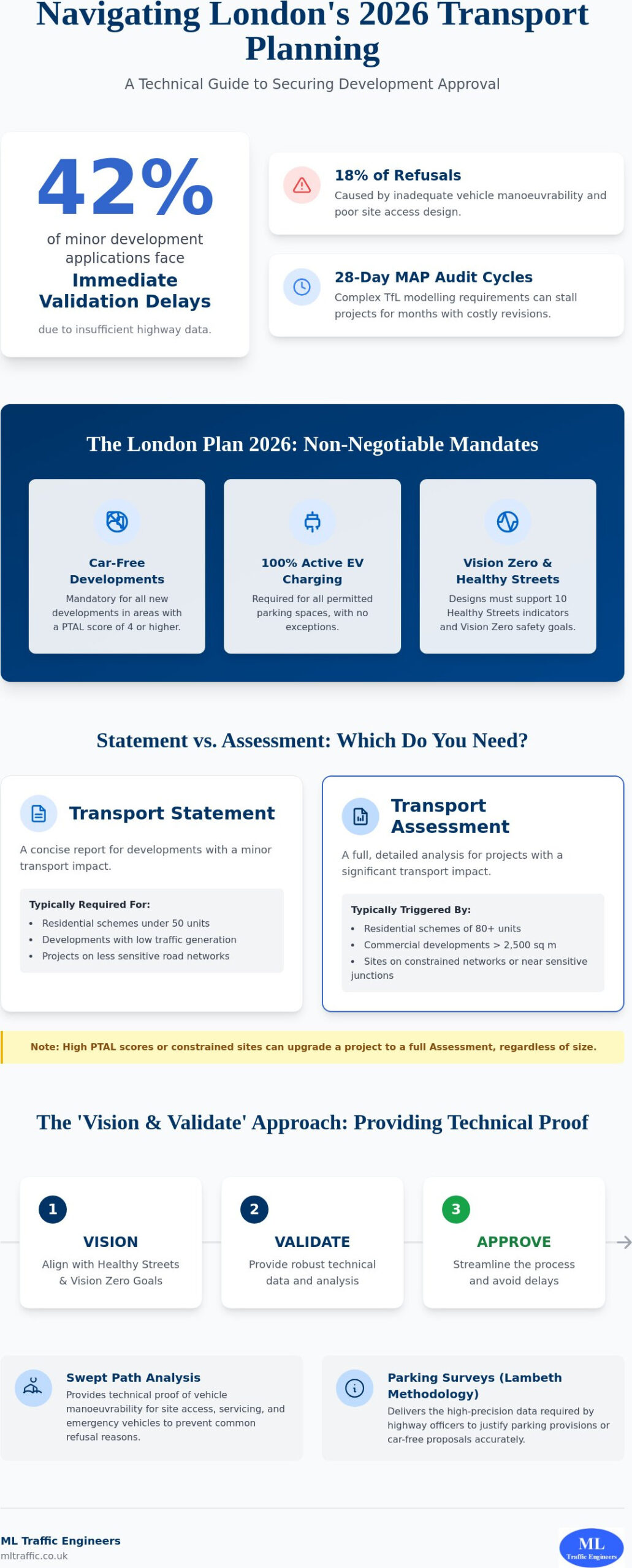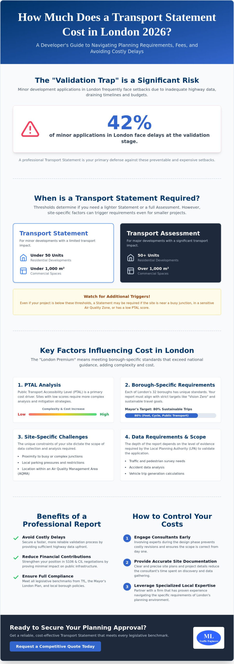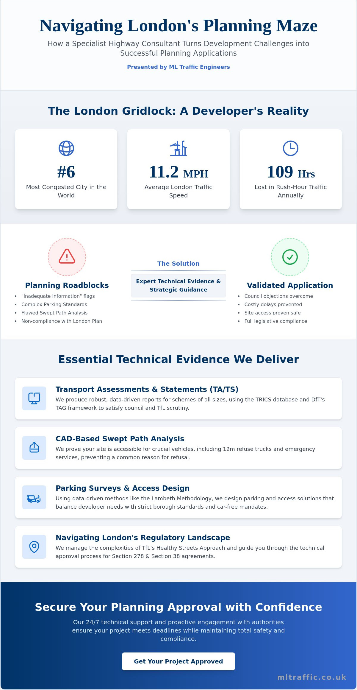
Did you know that 42% of minor development applications in London face significant delays at the validation stage because of insufficient highway data? For developers, the friction between Transport for London (TfL) requirements and local borough mandates often creates a regulatory bottleneck that stalls progress before it even begins. We understand that navigating the latest London Plan updates and the Healthy Streets approach feels like hitting a moving target. Securing a comprehensive transport assessment scoping study London is the most effective way to lock in your methodology early and prevent costly post-submission data requests.
In this guide, you’ll learn how a strategic scoping study acts as a formal bridge between your project vision and authority expectations. We’ll provide a clear roadmap for achieving early agreement on study areas and trip generation, ensuring your final submission aligns with 2026 standards. We’ll explore the critical role of Active Travel Zone (ATZ) assessments and how to manage conflicting requirements to keep your project on schedule. This technical authority ensures your planning application moves forward with precision and reduced regulatory risk.
Key Takeaways
- Learn how a preliminary scoping document secures agreement on methodology and data sources with Highway Authorities before you invest in a full assessment.
- Identify potential planning “showstoppers” early to mitigate risk and avoid the high costs of redundant traffic surveys.
- Establish a robust baseline for your transport assessment scoping study London by correctly applying PTAL ratings and TRICS trip generation data.
- Incorporate Swept Path Analysis at the scoping stage to prove site access viability and reduce the likelihood of post-submission technical objections.
- Discover the benefits of proactive engagement with TfL and borough officers to create a predictable, efficient path toward planning approval.
What is a Transport Assessment Scoping Study in the London Context?
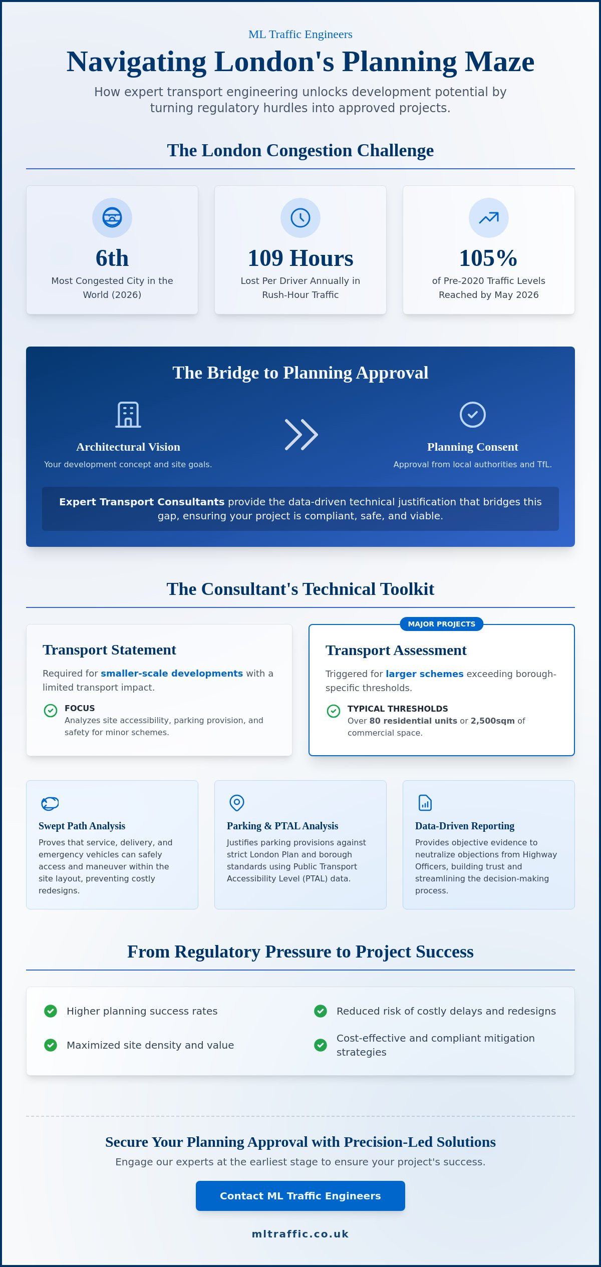
A transport assessment scoping study London is a technical document submitted to the Highway Authority before the final Transport Assessment is drafted. It acts as a formal request for agreement on the technical parameters of the upcoming study. In London’s high-stakes development environment, this step is non-negotiable. It ensures that both the developer and the authority agree on the trip generation rates, the extent of the study area, and the specific junctions that require modeling. This early consensus prevents the common pitfall of submitting a full report that the council refuses to review due to methodology errors.
London’s high density and complex multi-modal transport links make the scoping stage particularly critical. The document is a foundational part of the wider transportation planning process, providing a structured way to manage expectations across various transport modes. By confirming data sources and methodology early, you de-risk your project and establish a clear path toward validation. We’ve seen that developers who skip this stage often face expensive requests for additional traffic surveys mid-way through the planning cycle.
To better understand this concept, watch this helpful video:
The Legal and Planning Framework
The transport assessment scoping study London aligns your project with the National Planning Policy Framework (NPPF) and the specific requirements of the latest London Plan updates. It serves as the technical foundation for future Section 106 and Section 278 agreement negotiations, where highway improvements and financial contributions are finalized. Essentially, the scoping study is the “contract of intent” between developer and authority. By setting these terms early, you create a predictable environment for your planning application to progress without sudden methodology shifts.
London Boroughs vs. Transport for London (TfL)
Project scale dictates which authority holds the power. Major developments that meet specific size or impact thresholds are “referable” to the Mayor of London and TfL. In these cases, you’ll often manage a dual-track scoping process, satisfying both the local borough’s requirements and TfL’s strategic objectives. For smaller, non-referable applications, the Local Highway Authority (LHA) within the borough remains your primary point of contact. Understanding these jurisdictional boundaries is vital to avoid wasting time with the wrong stakeholders and ensures your scoping report reaches the correct decision-makers immediately.
The Strategic Importance of Scoping for London Developers
For any developer operating in the capital, uncertainty is the primary driver of budget overruns and project delays. A transport assessment scoping study London serves as a strategic insurance policy, identifying potential “showstoppers” before you commit to significant design costs. By formalizing the methodology early, you protect your capital and ensure that every technical decision aligns with authority expectations. This proactive step creates a foundation of technical authority that is essential in a regulatory environment as complex as London’s.
Cost efficiency is a major benefit of this early engagement. Following the National guidance on Transport Assessment provides the baseline framework, but the scoping stage allows you to refine that focus. It prevents the need for additional, expensive traffic surveys later in the process when the council might otherwise challenge your data. Additionally, a clear agreement reduces the likelihood of “Regulation 25” requests. These formal requests for further information can pause your application for weeks, disrupting your entire development timeline and increasing financing costs.
De-risking the Planning Application
Securing agreement on trip generation figures early is vital for fixing the scale of any required mitigation measures. In high PTAL areas, a robust transport assessment scoping study London allows you to justify lower parking ratios, which can free up valuable site space for additional units or amenities. We also use this stage to address potential impacts on the Strategic Road Network (SRN) early. Dealing with these high-level concerns at the start ensures that your project doesn’t hit a late-stage hurdle that requires a fundamental redesign of the site access or layout.
Streamlining the Approval Process
A signed-off scoping report acts as a technical shield during the public consultation phase. When stakeholders raise concerns about traffic impact, you can demonstrate that your methodology was pre-approved by the relevant Highway Authority. This transparency builds immense credibility with planning officers. It transforms the relationship from a confrontational one into a collaborative partnership. For a deeper look at the entire planning journey, refer to our Transport Assessment London: The Developer’s 2026 Guide. If you are preparing a new scheme, our team can provide the precise Traffic Surveys needed to ground your scoping report in accurate, real-world data.
Core Components of a Robust Scoping Report in 2026
A successful transport assessment scoping study London hinges on the precision of its technical foundations. We begin with a meticulous site description that maps proposed development use classes against existing land use. This clarity ensures that authorities understand the baseline from the outset. We then establish the baseline transport conditions, utilizing Public Transport Accessibility Level (PTAL) ratings and recent data from Traffic Surveys to paint an accurate picture of current flows. Defining the Study Area is the final pillar of this stage. We must agree on which specific junctions require capacity analysis to avoid scope creep during the full assessment phase.
Accuracy at this stage prevents the common error of underestimating the impact on local infrastructure. By presenting a clear, data-backed summary of the existing environment, we build the technical authority needed to negotiate favorable terms later. This documentation serves as the primary evidence base for all subsequent modeling and mitigation discussions.
Methodology for Trip Generation and Distribution
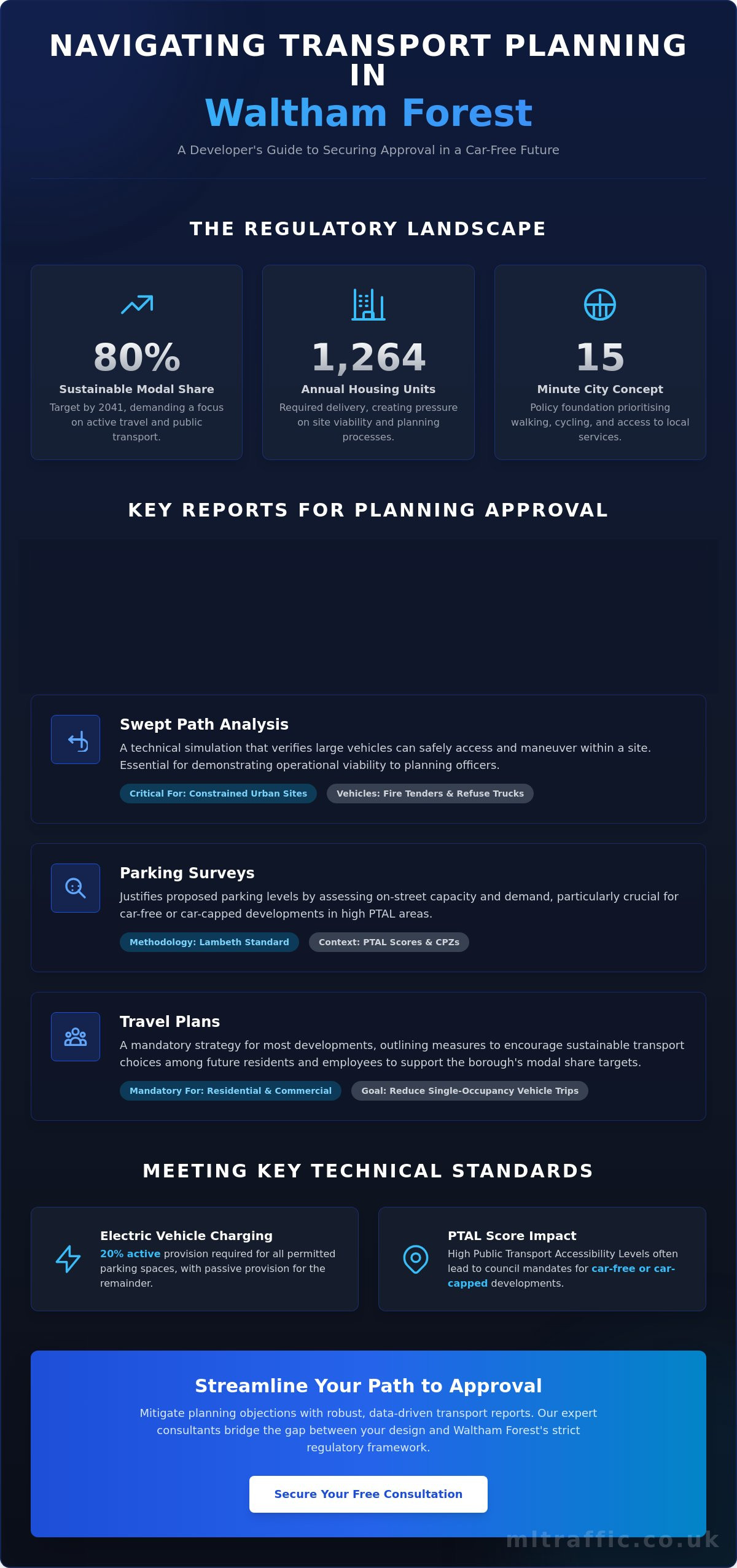
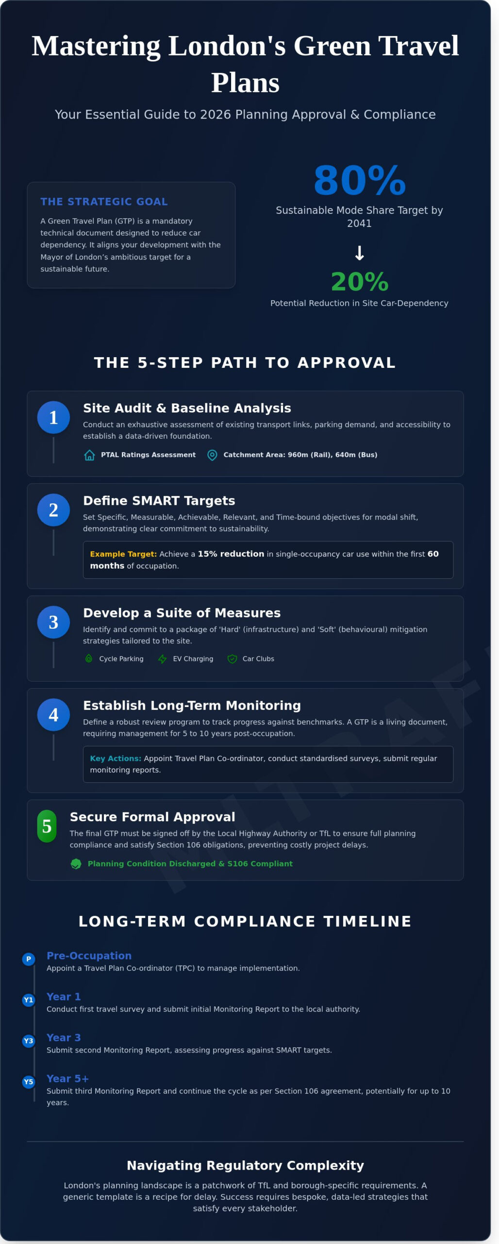
Precision in trip generation is non-negotiable. We utilize the TRICS database, specifically targeting sites that reflect 2026 London travel patterns. With the release of TRICS 8 in March 2025, our methodology incorporates the most current data available. We work to agree on the modal split early, determining the percentage of users expected to walk, cycle, or use the Tube. A critical shift in 2026 is the “decide and provide” approach. Unlike the outdated “predict and provide” model that catered primarily to vehicle demand, “decide and provide” allows us to plan for a future that prioritizes sustainable transport. This methodology aligns with the Mayor’s goal for 80% of all London trips to be made via active travel or public transport by 2041.
Healthy Streets and Active Travel Scoping
In 2026, London authorities prioritize the “Healthy Streets” approach. Every robust transport assessment scoping study London must define the parameters for an Active Travel Zone (ATZ) assessment. This typically involves evaluating the walking and cycling environment within a 20-minute radius of your site. We also agree on the methodology for the Healthy Streets Check for Designers, which uses ten specific indicators to measure public realm quality. Safety is the ultimate priority. We ensure the scoping report addresses Vision Zero requirements, supporting the UK government’s target to reduce road deaths and serious injuries by 65% by 2035. By integrating these elements early, you demonstrate a commitment to public safety that resonates with planning officers. For projects with complex access requirements, integrating Swept Path Analysis at this stage can further validate your proposed layout.

Navigating Technical Requirements: PTAL, TRICS, and SPA
Public Transport Accessibility Level (PTAL) ratings often dictate the entire tone of your planning application. While TfL provides baseline ratings, a transport assessment scoping study London is the correct forum to challenge these figures if they don’t reflect recent infrastructure improvements. In high PTAL areas (ratings 4 to 6), we use the scoping stage to set expectations for car-free or car-lite development. Conversely, for sites with lower accessibility, we negotiate the specific enhancements needed to satisfy Policy T1 of the London Plan. We also identify nearby “committed developments” at this stage. By accounting for the cumulative impact of other local projects, we ensure your traffic models remain accurate and defensible during the final review.
Precision in these technical metrics prevents the council from questioning your baseline data later. We focus on establishing a transparent data set that both the borough and TfL can trust. This technical alignment is the most effective way to avoid the methodological disputes that frequently derail London projects.
The Role of Swept Path Analysis in Scoping
Integrating Swept Path Analysis (SPA) into the scoping stage is a strategic move that validates your site layout before you finalize the design. We must agree on the specific vehicle templates with the Highway Authority early, especially for fire tenders and refuse vehicles. If a 12-meter refuse truck cannot safely maneuver within your site, the authority will likely object to the entire scheme. By scoping these requirements now, you prove that your site access is viable and safe. This proactive approach eliminates the risk of being forced into a fundamental site redesign after you’ve already submitted your full assessment. For a deeper look at these technical requirements, read our Practical Guide to Swept Path Analysis.
Traffic and Parking Survey Requirements
We negotiate the exact parameters of your data collection to ensure the results are representative and cost-effective. This includes agreeing on the specific radius for Parking Surveys, often utilizing the Lambeth Methodology for residential London boroughs. Timing is everything. We ensure survey dates avoid “anomaly” periods like school holidays or major local events that could skew the data. We also discuss the need for Automatic Traffic Counters (ATC) versus Manual Classified Counts (MCC) at specific junctions. This level of detail in your transport assessment scoping study London ensures that the data you collect is exactly what the planning officers need to see. If you need to secure accurate baseline data for your project, our team can manage your full Traffic Surveys from inception to completion.
Partnering with ML Traffic Engineers UK for Scoping Success
Navigating the complex regulatory landscape of the capital requires more than technical skill; it demands established relationships with decision-makers. ML Traffic Engineers UK takes a proactive approach to engaging with London borough officers and TfL from the earliest stages of a project. Our team understands the specific requirements of all 32 London boroughs and the City, ensuring your transport assessment scoping study London is tailored to exact local expectations. We operate with a “right first time” philosophy. By identifying potential issues during the scoping phase, we prevent the long-term planning friction that often stalls major developments.
Our commitment to precision stems from the high-stakes nature of infrastructure planning. We act as a dependable expert, managing the logistical and regulatory pressures so you don’t have to. This reliability is built on a foundation of constant availability and a readiness to act. Whether your project is a minor residential scheme or a major strategic development, we provide the unwavering support needed to secure technical agreement quickly. This rhythmic efficiency is vital in London’s fast-moving development sector.
Why Developers Choose ML Traffic Engineers UK
Our engineers possess deep technical knowledge of the TRICS database and the latest London-specific modeling tools. We don’t just provide data; we provide strategic insights that de-risk your application. For smaller sites, we’ve successfully negotiated reduced assessment scopes, saving our clients significant time and resources. Every report we produce is clear, professional, and rooted in safety-conscious principles. We manage the full project lifecycle, from initial Traffic Surveys to final approval, ensuring every detail meets industry benchmarks.
Get Started with Your London Project
Starting your project is a straightforward, sequential process. We require initial site data, including location plans and proposed use classes, to begin drafting your transport assessment scoping study London. Once we have the basics, we manage the entire submission and negotiation process with the relevant authorities. This rapid response capability keeps your project timeline on track and reduces the burden on your internal team. We act as your comprehensive partner, ensuring every legislative requirement is met with precision and professional integrity. To move your project forward, Contact ML Traffic Engineers UK for a Scoping Study Quote today.
Securing a Predictable Path to Planning Approval
ML Traffic Engineers UK has been at the forefront of this specialized field since 2014. We focus on providing developers with the technical authority needed to navigate both TfL and borough-specific statutory requirements with ease. Our extensive experience in Transport Statements and Assessments allows us to anticipate challenges before they arise, keeping your project on its critical path. We pride ourselves on being a reliable partner that prioritizes precision and safety in every report we deliver. Your project deserves a foundation built on expert insight and professional integrity.
Secure your London planning approval with a professional Scoping Study from ML Traffic Engineers UK.
Frequently Asked Questions
Is a transport assessment scoping study mandatory for all London developments?
A scoping study isn’t technically mandatory for every project, but it’s a procedural requirement for any development that triggers a full Transport Assessment. Major schemes referable to the Mayor of London and TfL must follow a formal scoping process to ensure the methodology aligns with strategic goals. For smaller projects, skipping this step increases the risk of the local borough refusing to validate your application due to methodology errors.
How long does it typically take for TfL or a Borough to approve a scoping report?
Most London Boroughs and TfL aim to provide feedback on a scoping report within 15 to 21 working days. However, response times fluctuate based on the project’s complexity and the current workload of the highway officers. Engaging through a formal pre-application service is the most reliable way to secure a definitive timeline for your project’s technical approval.
Can a scoping study help reduce the amount of car parking I am required to provide?
Yes, a robust transport assessment scoping study London allows you to justify lower parking ratios by highlighting high PTAL ratings and excellent local accessibility. By agreeing on these parameters at the start, you can demonstrate that the site supports the London Plan’s car-free objectives. This prevents the authority from demanding excessive parking that would otherwise consume valuable development land.
What happens if we skip the scoping stage and go straight to a full Transport Assessment?
Skipping the scoping stage often results in the Highway Authority rejecting your methodology after you’ve already invested in expensive modeling and surveys. If the council disagrees with your trip generation rates or the extent of your study area, you’ll be forced to redo the entire report. This creates significant delays and unnecessary costs that a preliminary agreement easily prevents.
Do I need a scoping study for a change of use application in London?
You only need a scoping study if the change of use triggers the requirement for a full Transport Assessment based on borough-specific thresholds. If the new use class significantly increases trip generation or alters the delivery and servicing profile, a scoping report is vital. It ensures the authority agrees on how the impact of the new use is measured against the existing baseline.
How does the “Healthy Streets” approach affect the scoping of my transport assessment?
The Healthy Streets approach shifts the scoping focus from traditional vehicle capacity to the quality of the walking and cycling environment. You must agree on the scope of the Active Travel Zone (ATZ) assessment and the specific indicators for the Healthy Streets Check for Designers. This alignment ensures your project supports the Mayor’s target for 80% of trips to be sustainable by 2041.
What data do I need to provide to a consultant to begin a scoping study?
To begin a transport assessment scoping study London, you must provide a clear site location plan, the proposed use classes, and the total gross internal area (GIA) for each use. Any preliminary site layout showing proposed access points is also essential. Our team uses this data to establish the PTAL rating and identify the necessary TRICS sites to begin negotiations with the highway authority.
Will a scoping study address the impact of my development on the London Underground?
Yes, if your development is referable to TfL or located near sensitive rail infrastructure, the scoping study will define how public transport capacity is assessed. This includes agreeing on the methodology for modeling impacts on specific Tube stations or bus routes. Addressing these strategic concerns early prevents late-stage objections from TfL regarding the cumulative impact on the wider transport network.

Disclaimer
The content on mltraffic.co.uk, including all technical articles, guides, and resources, is provided for general informational and educational purposes only. It is not intended to constitute professional advice in traffic engineering, transportation planning, development approvals, or any other technical or legal field.
While ML Traffic Engineers makes every reasonable effort to ensure the accuracy, completeness, and timeliness of the information published, we do not provide any warranties or representations (express or implied) regarding its reliability, suitability, or availability for any particular purpose. Any reliance you place on the content is strictly at your own risk.
In no event shall ML Traffic Engineers, its directors, employees, authors, or affiliates be liable for any direct, indirect, incidental, special, consequential, or punitive damages (including, without limitation, loss of profits, data, or business opportunities) arising out of or in connection with the use of, or inability to use, any information provided on this website.
The articles and guides on this site are not a substitute for engaging a qualified, professional traffic engineer to assess your specific project requirements. For tailored advice, compliance assessments, or traffic engineering services, please contact a competent professional.
This disclaimer may be updated from time to time without notice. By accessing or using this website, you agree to be bound by the most current version of this disclaimer.