A delayed section 38 agreement is more than just a paperwork bottleneck; it’s a direct drain on your project’s liquidity that can trigger bond claims before the first resident moves in. Securing approval from London boroughs requires more than a standard application. It demands a technical strategy that accounts for specific local fees, such as the £185.86 hourly pre-application rates charged by Barnet Council as of April 2026.
You already know that missing a single technical detail or miscalculating a commuted sum can stall your road adoption for months. It’s frustrating when the lines between Section 38 and Section 278 requirements blur, leading to unexpected costs and regulatory friction. As experts in managed traffic solutions, we’ve built this guide to help you master these complexities and secure highway adoption without the typical financial strain.
You’ll gain a clear roadmap for the s38 process, from initial CAD design to the final 12 month maintenance period. We’ll also explain how to manage the 8% works cost fees in Lewisham and how to navigate TfL involvement so your project stays on schedule and remains fully compliant. This is your definitive resource for ensuring a seamless transition from construction to public maintenance.
Key Takeaways
- Follow a clear, step-by-step roadmap to transition your new highway infrastructure from private construction to public maintenance efficiently.
- Differentiate between a section 38 agreement for new roads and Section 278 requirements for existing highway modifications to prevent legal and financial overlaps.
- Master technical audit submissions by aligning your CAD designs and lighting plans with the latest 2026 London borough design standards.
- Leverage Transport Assessments to justify road hierarchy and streamline the approval process with local authorities and Transport for London.
- Reduce financial risk by negotiating adoption-friendly designs that minimize the long-term impact of commuted sums and surety bond requirements.
Table of Contents
-
Section 38 vs. Section 278: Navigating London’s Highway Legalities
-
Technical Approval Requirements for a Successful s38 Agreement
-
Securing Your s38 Agreement: How Professional Transport Planning Ensures Success
Understanding Section 38 Agreements for London Developments
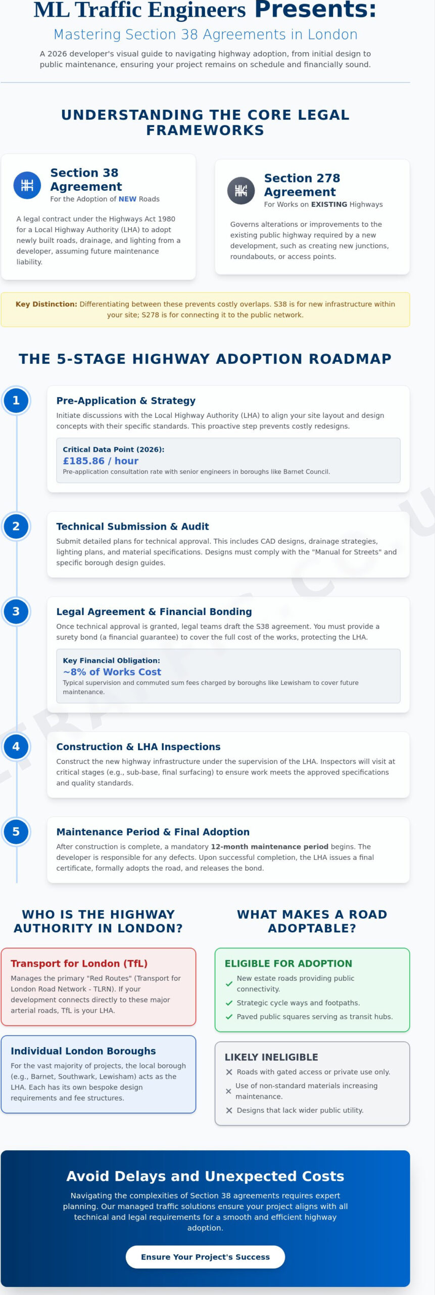
A section 38 agreement is a legal contract made under the Highways Act 1980 between a developer and the Local Highway Authority (LHA). In the high-density environment of London, this agreement serves as the standard mechanism for creating new public infrastructure. It ensures that once you’ve built a road to the required technical specifications, the local council takes over its future maintenance and liability. Without this transfer, developers remain responsible for long-term repairs, drainage, and lighting costs, which can significantly erode the profitability of a project. It’s a technical milestone that validates the quality of your construction while protecting your long-term balance sheet.
For a deeper dive into the legal framework and terminology, Understanding Section 38 Agreements provides a solid foundation for project managers. The LHA plays a dual role as both the technical auditor and the eventual owner of the asset. They don’t just sign off on the finished product; they inspect the work at every critical phase to ensure it meets safety and durability standards. In London, where space is at a premium and utility networks are complex, the LHA’s involvement is a non-negotiable safeguard for public safety and civic integrity.
To better understand this concept, watch this helpful video:
Who is the Highway Authority in London?
London’s governance structure creates a unique challenge for developers. Unlike other UK regions, authority is split. Transport for London (TfL) manages the Transport for London Road Network (TLRN), commonly known as red routes. If your development connects directly to these arterial roads, TfL is your primary contact. However, for the vast majority of residential developments, the individual London Borough is the LHA. Identifying your authority early is vital. Borough engineers in Barnet, Harrow, or Southwark often have bespoke design requirements that differ from TfL’s standards. We recommend initiating pre-application discussions immediately after your initial site layout is drafted. This proactive approach prevents costly redesigns and ensures your section 38 agreement moves through the approval pipeline without friction.
What Roads are Eligible for Adoption?
Not every piece of tarmac is eligible for adoption. To qualify, a road must serve a wider public utility beyond just accessing a few private properties. It needs to provide meaningful connectivity to the existing network and adhere to the "Manual for Streets" and specific borough design guides. Common examples of adoptable infrastructure include:
-
New Estate Roads: Primary routes through residential developments are standard candidates.
-
Cycle Ways and Footpaths: Strategic links that promote sustainable travel are highly prioritized in 2026 planning.
-
Public Squares: Some boroughs adopt paved public spaces if they serve as transit nodes or public thoroughfares.
Private roads often remain private because they fail to meet technical standards or lack public utility. If your design includes gated access or non-standard materials that increase maintenance costs, the council will likely refuse adoption. We help you navigate these criteria during the planning phase to ensure your assets are adoption-ready from day one.
The Step-by-Step Section 38 Application Process in 2026
Securing a section 38 agreement isn’t a passive wait for approval. It’s a proactive, five-stage cycle that requires technical precision and steady communication. You start with pre-application discussions. In Barnet, as of April 2026, these sessions cost £185.86 per hour for senior engineer input. This initial investment prevents expensive redesigns later in the project lifecycle. Once the borough gives the green light, you move to the technical audit submission, which is the most rigorous phase of the process.
Preparing the Technical Audit Package
Your audit package is the backbone of the application. It must include detailed site plans, cross-sections, and longitudinal sections that meet the borough’s specific standards. A critical component for any London site is Swept Path Analysis. This digital simulation proves that emergency vehicles and refuse trucks can navigate your layout without mounting curbs or hitting structures. In London, your drainage strategy must also incorporate Sustainable Drainage Systems (SuDS) to manage surface water runoff effectively and prevent local sewer overloads.
The legal phase involves drafting the contract based on the Highways Act 1980 Section 38. At this stage, you must secure a financial surety bond. This bond acts as a guarantee for the borough. If a developer defaults, the council uses these funds to complete the works. In Lewisham, the agreement fee is typically 8% of the total works’ cost, with an additional £5,000 application fee for projects exceeding £100,000. We’ve seen how precise planning at this stage saves weeks of legal back-and-forth.
Construction begins only after the section 38 agreement is signed and the bond is in place. Borough inspectors will visit the site at key milestones, such as the laying of the sub-base and drainage installation. If you’re looking for a partner to manage these high-stakes technical requirements, explore what we do to support London developers. After construction, the council conducts a final walk-through before issuing a Provisional Certificate.
Navigating the Maintenance Period
The Provisional Certificate triggers the 12 month maintenance period. You’re still liable for any defects during this year. It’s a testing phase where the road is open to the public but technically remains your responsibility. Keep your site teams ready for immediate repairs to avoid bond claims. At the end of the year, a final inspection occurs. Once all snags are cleared and the health and safety file is handed over, the borough issues the Final Certificate. This document officially transfers the road into public ownership and releases the remainder of your bond.
Section 38 vs. Section 278: Navigating London’s Highway Legalities
Understanding the boundary between new construction and existing infrastructure is the first step toward a successful section 38 agreement. A Section 38 agreement focuses exclusively on the adoption of entirely new roads built on private land. In contrast, a Section 278 agreement covers alterations to the existing public highway. In London, this distinction is critical. If you’re building a new residential estate in Ealing, the internal roads fall under Section 38. However, the moment your team cuts into the existing pavement to create a site entrance or a new bellmouth junction, you’ve entered Section 278 territory.
Financial structures also differ between these two mechanisms. While Section 38 involves a 12 month maintenance period after construction, Section 278 works often require immediate adoption once the defects period ends. London boroughs like Lewisham apply an 8% fee on the works’ cost for technical auditing and supervision across both types. Managing these legalities requires precision to avoid planning bottlenecks that stall your site’s progress.
When Do You Need Both?
Most major London developments require a hybrid approach. Consider a high-density residential block in Southwark. The project might include a new internal courtyard road and a junction upgrade on the adjacent borough road to handle increased traffic. Managing these as separate workstreams often leads to conflicting inspection schedules and legal delays. Combining them into a single legal document streamlines the process. It ensures a unified technical audit and a single point of contact for borough engineers. For a deep dive into managing these dual requirements, read our Highway Design S278 & S38 Pillar Guide.
The Role of Surety Bonds and Commuted Sums
London boroughs require a financial surety bond to protect the public purse. This bond typically covers 100% of the estimated works cost. If a project in Barnet exceeds £2 million, these fees and bond requirements are subject to individual negotiation with the council. Commuted sums are an increasing trend in 2026. These are one-off payments from developers to cover future maintenance of non-standard features. If your section 38 agreement includes bespoke street furniture, specialized LED lighting, or Sustainable Drainage Systems (SuDS), expect a commuted sum request. These payments offset the long-term budget constraints of local authorities. We recommend calculating these potential costs early by totaling your construction estimates, including 24/7 traffic management contingencies and emergency response provisions.
Technical Approval Requirements for a Successful s38 Agreement
Technical approval is the phase where a section 38 agreement moves from a legal concept to a physical engineering reality. London boroughs evaluate your submission against the "Manual for Streets" and their own specific design guides. Precision here is non-negotiable. If your CAD designs don’t align with local standards, you face immediate rejection and costly redesigns. Your engineering team must demonstrate that every element of the new road is durable, safe, and easy to maintain.
A robust Transport Assessment serves as the foundation for this approval. It provides the data-driven justification for your road hierarchy, ensuring that proposed widths and visibility splays match the expected traffic volume and speed. We also ensure your signage and lighting plans meet Chapter 8 compliance, which is the national standard for traffic signs. When selecting materials, prioritize standard borough palettes. While bespoke finishes like high-grade granite might look superior, they often lead to friction. Councils prefer standard materials because they’re easier and cheaper to replace. Choosing non-standard finishes will almost certainly result in a higher commuted sum request to cover specialized maintenance costs.
Swept Path Analysis and Access Design
Ensuring that heavy vehicles can maneuver safely is a primary concern for borough engineers. Swept Path Analysis is the digital simulation of vehicle movement to ensure geometric compliance. We use this to prove that 11.4 meter refuse vehicles and standard fire tenders can navigate your new estate roads without mounting curbs. Common pitfalls in London site access design that lead to section 38 agreement rejection include:
-
Inadequate visibility splays at junctions that don’t account for parked cars.
-
Tight corner radii that fail digital tests for emergency vehicle access.
-
Incorrect placement of street furniture that obstructs pedestrian flow or vehicle paths.
Drainage and Utilities Coordination
Your technical package must account for the complex web of underground services. Coordination with utility providers like Thames Water is essential, especially when managing the interface between private service strips and the public highway. We also cross-reference all designs with the Environment Agency’s Flood Map for Planning. This ensures your Sustainable Drainage Systems (SuDS) can handle a 1 in 100 year storm event plus a 40% allowance for climate change. Failing to prove adequate drainage capacity is one of the fastest ways to stall a technical audit in 2026. You must prove that surface water won’t pool on the adopted highway or overwhelm the existing local sewer network.
Ready to ensure your technical package meets every London borough requirement? Consult our traffic engineering experts to streamline your approval process and avoid costly redesigns.
Securing Your s38 Agreement: How Professional Transport Planning Ensures Success
Developers often hit a wall because they treat the section 38 agreement as a post-planning afterthought rather than a core engineering requirement. Incomplete technical packages and fragmented communication with Local Highway Authorities (LHAs) are the primary drivers of project delays. When a borough engineer receives a sub-standard CAD drawing or a drainage strategy that ignores local flood maps, the revision cycle begins. These cycles can stall a project for months, locking up capital in unreleased bonds and delaying site handovers. Precision is a legal and physical necessity in London’s high-stakes development environment.
Expert traffic engineers provide the technical authority needed to bridge the gap between planning permission and highway adoption. We negotiate "adoption-friendly" designs that balance your architectural vision with the council’s maintenance requirements. This involves selecting standard material palettes that reduce commuted sums and ensuring every junction radius is optimized for safety. By positioning yourself as a dependable partner to the LHA, you minimize the risk of default or bond claims. We act as your safe pair of hands, managing the intricate complexities of UK road regulations so you don’t have to.
The ML Traffic Advantage in London
Our team brings extensive experience working with London Boroughs from Harrow to Greenwich. We understand that each authority has unique preferences, from specific lighting lux levels to bespoke cycle lane widths. Our technical reports and surveys provide the high-quality data LHAs demand to approve a section 38 agreement without multiple rounds of questioning. We provide total, managed solutions that cover everything from initial consultation to final implementation. If you’re ready to move your project forward, contact us for a bespoke s38/s278 consultancy quote.
Reducing Risk and Delay
Proactive management is the only way to avoid the common pitfalls of highway adoption. You must ensure your Construction Logistics Plan aligns perfectly with your highway adoption goals. If your construction traffic routes conflict with the proposed adoptable areas, you risk damaging new infrastructure before the maintenance period even begins. Use this final checklist before submitting your application:
-
Confirm all Swept Path Analysis simulations use the 11.4 meter refuse vehicle standard.
-
Verify that SuDS designs have been pre-approved by the Lead Local Flood Authority (LLFA).
-
Ensure Chapter 8 compliance for all proposed temporary and permanent traffic signals.
-
Coordinate with Thames Water to ensure no utility easements conflict with the adoption footprint.
-
Secure a financial surety bond provider early to avoid legal bottlenecks at the contract stage.
Our 24/7 readiness and commitment to professional integrity ensure that your project remains compliant and on schedule. We move straight to the core of your technical challenges, providing the rhythmic efficiency required in the fast-moving London construction sector. Transitioning from planning to adoption doesn’t have to be a regulatory burden when you have an organized expert managing the lifecycle of your traffic management project.
Streamline Your London Highway Adoption Today
Securing a section 38 agreement is a technical engineering milestone that requires absolute precision from the initial CAD design through to the final certificate of adoption. You’ve seen how differentiating between new road construction and existing highway modifications prevents costly legal bottlenecks. Successful adoption in 2026 relies on early engagement with London boroughs and a technical package that satisfies rigorous standards for drainage, lighting, and vehicle maneuverability.
ML Traffic provides the technical authority you need to navigate these regulatory burdens. With over 10 years of London traffic engineering expertise, we specialize in the Swept Path Analysis and Transport Statements that borough highway authorities demand. Our proven track record across all 32 boroughs ensures your project remains compliant and your financial bonds are protected. We manage the high-stakes logistics so you can focus on delivery.
Don’t let technical delays drain your project’s resources. Get Expert Technical Support for Your Section 38 Agreement and ensure your infrastructure is adoption-ready from day one. Our team is ready to provide the reliable, professional guidance your development deserves.
Frequently Asked Questions
What is the difference between a Section 38 and a Section 278 agreement?
A section 38 agreement facilitates the adoption of entirely new roads built by a developer on private land. In contrast, a Section 278 agreement is required for any work on existing public highways, such as creating a new site access or junction. Many London projects require both to connect new internal infrastructure to the wider borough network. You’ll need separate technical approvals for each workstream to satisfy the Local Highway Authority.
How much does a Section 38 agreement cost in London?
Costs vary by borough but typically include pre-application fees and a percentage of the total works cost. In the London Borough of Barnet, as of April 2026, pre-application meetings cost £185.86 per hour for senior engineer input. Lewisham Council charges a fee of 8% of the works cost, plus a £5,000 application fee for major works exceeding £100,000. These figures don’t include the cost of the mandatory surety bond.
How long does the Section 38 adoption process take?
The entire cycle from initial design to final adoption generally takes 18 to 24 months. This timeline includes 3 to 6 months for technical approval and a mandatory 12 month maintenance period after construction. Delays often occur during the technical audit phase if CAD designs don’t meet Chapter 8 compliance or local drainage standards. Engaging with borough engineers during the pre-application phase is the best way to compress this schedule.
Is a Section 38 agreement mandatory for all new developments?
No, it isn’t legally mandatory to enter a section 38 agreement, but it’s standard practice for residential developments. If you don’t secure an agreement, the roads remain private, meaning the developer or a management company must fund all future repairs, lighting, and drainage. Most mortgage lenders require roads to be adoptable to protect property values, making it a commercial necessity for most housing projects in London.
What happens if a developer defaults on a Section 38 agreement?
If a developer defaults, the Local Highway Authority (LHA) uses the financial surety bond to complete the roadworks. This bond usually covers 100% of the estimated construction costs. The LHA will step in, appoint their own contractors, and finish the project to ensure the road reaches a safe, adoptable standard for the public. This process protects the borough from inheriting unfinished or dangerous infrastructure at the taxpayers’ expense.
Can a London borough refuse to adopt a road under Section 38?
Yes, a London borough can refuse adoption if the road lacks public utility or fails to meet geometric standards. Roads that only serve a small number of private houses or include gated access don’t qualify for adoption. To avoid refusal, ensure your design adheres to the "Manual for Streets" and provides a clear benefit to the wider transport network. Technical approval must be secured before any construction begins on site.
What is a commuted sum in an s38 agreement?
A commuted sum is a one-off payment made by the developer to cover the future maintenance costs of non-standard highway features. This includes items like specialized LED street lighting, high-spec paving, or Sustainable Drainage Systems (SuDS). Boroughs calculate these sums to ensure the public purse isn’t burdened by the higher upkeep costs of bespoke designs. Choosing standard borough materials is the most effective way to reduce these financial requirements.
Do I need a Section 38 agreement for a private gated community?
No, you don’t need a section 38 agreement for a gated community because these roads aren’t intended for public use. By definition, an adoptable highway must be open to all members of the public at all times. If you choose to gate a development, you must establish a private management company to handle all long-term maintenance and infrastructure liabilities. This includes 24/7 emergency repairs and the ongoing cost of utility coordination.
Which areas in London do you cover?
We service Acton, Balham, Barking, Barnes, Barnet, Battersea, Beckenham, Bexleyheath, Brentford, Brixton, Bromley, Camberwell, Carshalton, Charlton, Chelsea, Chiswick, Clapham, Coulsdon, Croydon, Crystal Palace, Dagenham, Dulwich, Ealing, Edgware, Eltham, Enfield, Finchley, Forest Gate, Fulham, Golders Green, Greenwich, Hackney, Hammersmith, Hampstead, Harrow, Hayes, Highgate, Hounslow, Ilford, Islington, Kensington, Kentish Town, Kingston upon Thames, Lewisham, Mitcham, Muswell Hill, New Malden, Notting Hill, Orpington, Peckham, Pinner, Purley, Putney, Richmond, Romford, Ruislip, Sidcup, Southall, Southgate, Streatham, Surbiton, Sutton, Tooting, Tottenham, Twickenham, Uxbridge, Walthamstow, Wembley, West Norwood, Wimbledon, Wood Green, Woolwich, Bethnal Green, Shoreditch, Canary Wharf, Deptford, Leyton, Palmers Green, Stanmore, Upminster, Chislehurst, Erith, Feltham.
Which cities in England do you cover?
We service London, Birmingham, Manchester, Liverpool, Sheffield, Leeds.

Disclaimer
The content on mltraffic.co.uk, including all technical articles, guides, and resources, is provided for general informational and educational purposes only. It is not intended to constitute professional advice in traffic engineering, transportation planning, development approvals, or any other technical or legal field.
While ML Traffic Engineers makes every reasonable effort to ensure the accuracy, completeness, and timeliness of the information published, we do not provide any warranties or representations (express or implied) regarding its reliability, suitability, or availability for any particular purpose. Any reliance you place on the content is strictly at your own risk.
In no event shall ML Traffic Engineers, its directors, employees, authors, or affiliates be liable for any direct, indirect, incidental, special, consequential, or punitive damages (including, without limitation, loss of profits, data, or business opportunities) arising out of or in connection with the use of, or inability to use, any information provided on this website.
The articles and guides on this site are not a substitute for engaging a qualified, professional traffic engineer to assess your specific project requirements. For tailored advice, compliance assessments, or traffic engineering services, please contact a competent professional.
This disclaimer may be updated from time to time without notice. By accessing or using this website, you agree to be bound by the most current version of this disclaimer.