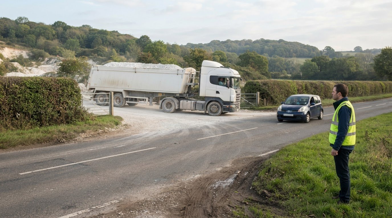
A quarry’s transport case is about more than the number of lorries reaching the site. A transport assessment for a quarry examines potential transport impacts and sets out measures to address adverse effects.
It’s understandable to focus first on heavy goods vehicles and the routes they’ll use. A useful transport assessment for a quarry also brings together the evidence needed to explain traffic effects and identify relevant mitigation. This guide covers supporting documents, relevant local and specialist consultees, and how decision-makers consider transport impacts when assessing a quarry proposal.
Trip estimates, highway conditions and operating arrangements all shape the assessment. The aim is to make the process easier to follow, from the evidence gathered to the planning questions it needs to answer.
Key Takeaways
- Match the assessment and supporting evidence to the quarry’s operating arrangements, access and likely effects on the surrounding network.
- Plan consultation around the relevant local and specialist consultees, and allow time for their responses to inform the application.
- In England, focus the planning case on highway safety and whether the effect on the road network would be severe.
- Use loading, unloading and travel-time assumptions to explain how quarry activity translates into vehicle movements.
- Choose between a Transport Assessment and a Transport Statement based on the scale and transport effects of the proposal.
Assessments and supporting documents
A transport assessment for a quarry explains how the proposal could affect access, vehicle movements and the surrounding highway network. Its evidence should connect quarry operations to likely traffic effects and practical mitigation.
Required Assessment Information
A transport assessment is a structured review of a development’s transport effects and supporting evidence.
For a quarry, describe the site, access arrangements, operations and expected vehicle movements. Set out existing transport conditions, then explain how the proposal could affect traffic on relevant routes and junctions. Include trip generation, distribution and assignment so readers can follow how estimated movements reach the local network. Assess access suitability, road capacity, safety and effects on other road users. Identify mitigation where the analysis shows it is needed.
State assumptions clearly and link each finding to the planning case. Readers should be able to trace the assessment from quarry activity through route choice to the identified highway effects.
Applicable Standards and Guidance
Applicable guidance is the national and local planning framework used to scope and prepare an assessment.
Identify the planning authority and highway authority responsible for the site before setting the evidence scope. Department for Transport guidance and local planning requirements inform the assessment, while the relevant expectations depend on the application’s location and characteristics. Explain which guidance shaped the method and how local requirements informed the scope.
For a London proposal, the London transport assessment guide provides a location-specific reference. Keep the assessment tied to the site’s applicable requirements rather than importing another authority’s approach.
HGV Routes and Road Capacity
Route and capacity analysis examines how quarry HGV movements interact with roads and junctions.
Map the proposed HGV routes from the site access to the wider network, explaining why each route is suitable. Compare existing traffic conditions with forecast movements, then examine junctions where additional traffic could affect operation. UK transport assessments commonly model future highway conditions at least 5 years after the assessment. TRICS is commonly used to estimate and validate proposed development trip generation.
Explain peak-period assumptions and how quarry operating patterns shape traffic. This helps decision-makers identify which routes or junctions need closer analysis, rather than relying on total vehicle numbers alone.
Road Safety and Other Road Users
Road safety analysis considers how quarry traffic could affect people using the access and nearby routes.
Review available personal injury collision data for the most recent five-year period, and explain the study area and its relevance to the site. Assess how HGV movements interact with pedestrians, cyclists and public transport, including at access points and along routes. Describe any identified safety concerns and how the assessment addresses them.
Mitigation may include a routing plan or physical highway changes, selected to address identified effects. Explain how each measure responds to the evidence and whether it can be delivered within the adopted highway or on land controlled by the applicant. In operational contexts, fleet risk management and professional safety training—such as the driver education programmes offered by drivingsense.co.za—can also help mitigate risks associated with heavy vehicle movements.
Consultation with local and specialist consultees
Consultation gathers relevant authority and community views on a quarry proposal. Local planning authorities assess transport evidence alongside likely effects on access, routes and the surrounding highway network. The consultation approach depends on the proposal’s location and the issues raised by its transport impacts.
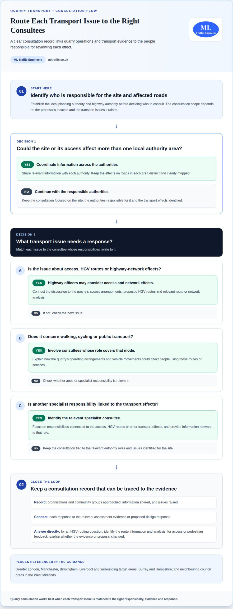
For a quarry in Greater London, Manchester, Birmingham, Liverpool or surrounding target areas, first identify the local planning authority and highway authority responsible for the site and affected roads. Then identify specialist consultees whose responsibilities relate to the access, HGV routes or other transport effects. This helps focus the consultation.
Consultation is most useful when each party receives information relevant to its role. Highway officers may consider access and network effects, while other consultees may focus on walking, cycling or public transport. Match each issue to the appropriate evidence, and explain how the quarry’s operating arrangements could affect it.
Keep a clear consultation record. Note which organisations and community groups were approached, what information they received and the issues they raised. Connect each response to the relevant assessment evidence or proposed design response. This helps the planning authority follow how feedback informed the application.
If a site or its access could affect more than one local authority area, coordinate the information shared with each authority. For example, a quarry near a boundary in Greater London or between neighbouring councils in the West Midlands may require the application team to explain effects on roads in each area. Keep those effects distinct and clearly mapped.
Address responses directly. If a consultee raises a question about HGV routing, identify the route information and analysis that answer it. If feedback highlights access or pedestrian movement, explain whether the evidence or proposal has changed. A concise response maintains a traceable connection between consultation and the planning material.
For projects in Surrey, Hampshire or other target areas, early coordination can help align transport evidence with local questions. Keep consultation material specific to the site, authority responsibilities and issues raised. This gives decision-makers a coherent record of who was consulted and how feedback informed the quarry proposal.
For structured transport documentation to support a planning application, explore transport planning support.
this proposal should also make the timing and scope of engagement clear. Pre-application consultation for the quarry proposal was carried out in February 2022 and again in October 2022. Consultees were given a minimum of 28 days to respond to or ask questions about the quarry development. Set out the material shared in each phase and retain the responses alongside the transport evidence, so that questions can be followed through to the relevant assessment or design response.
Ward boundary changes that took effect in May 2022 led to further pre-application consultation for the quarry proposal in October 2022. Explain which consultees were included following those changes and consider comments from the later engagement alongside earlier feedback. A clear chronology helps distinguish the original consultation from the additional engagement and gives the planning authority a transparent account of how local representation and transport concerns were addressed.
Development acceptability under the NPPF
Development acceptability is the planning judgement on whether a quarry’s transport effects are acceptable. In England, the National Planning Policy Framework (NPPF) provides the national policy test for considering highway impacts. Connect evidence about traffic, safety and the road network to that test.
The NPPF says a development should not be refused on highway grounds unless it would have an unacceptable effect on highway safety or a severe effect on the road network. These are distinct tests. Explain both the safety consequences and the network effects, rather than relying on a general statement that traffic will increase.
For a clear policy response, set out the proposal’s effects and show how the assessment reaches its conclusions. Explain the relevant routes, junctions and traffic assumptions, then identify any effects that need mitigation. Decision-makers can then see how the evidence relates to the NPPF’s highway refusal tests. A forecast increase in traffic is not, by itself, a conclusion.
Leicestershire assessments are expected to demonstrate how a development sits against paragraph 115 of the NPPF. They must also demonstrate that the proposal is acceptable against the refusal tests in paragraph 116. Present these paragraphs separately in the planning case: explain the paragraph 115 position, then address the paragraph 116 tests directly.
Mitigation forms part of the acceptability case when the analysis identifies transport effects requiring a response. In Leicestershire, highway mitigation must be deliverable within the adopted highway or on land under the applicant’s control. Full mitigation is likely to be required before first occupation or opening, unless a phased strategy is appropriate and aligned with development build-out phases.
Timing matters for quarry proposals because opening and operational phases can shape when traffic effects arise. Set out how mitigation delivery relates to the relevant development phase. If using a phased strategy, explain how each measure aligns with build-out and when it addresses the associated effects. This makes the proposed approach easier to assess against forecast conditions.
A Welsh example shows why the planning authority’s transport response should be reported precisely. Rhondda Cynon Taf Highways and Transportation considered the quarry development acceptable as submitted. This is a case-specific consultee view, not a substitute for explaining the evidence or a general outcome for other quarry applications.
For applications outside England, identify the relevant national and local planning framework rather than applying the NPPF test automatically. For an English application, finish with a concise policy summary: state the safety conclusion, the network conclusion and how any necessary mitigation will be delivered. This gives the decision-maker a traceable route from transport evidence to the planning judgement.
Dumper loading and unloading times
A dumper cycle is the sequence of loading, travelling, unloading and returning for another load. Estimating quarry traffic generation starts with production requirements and vehicle payload, then considers how many cycles the operation needs. Keep internal dumper movements separate from HGV trips entering or leaving the site. They describe different parts of quarry transport.
In one quarry transport study, the operation required 3,800 tons of stone each day for processing. Dumpers had a capacity of 35 tons, and the system needed to unload 109 dumpers per day. These figures show how production and vehicle capacity inform movement estimates. They are case-specific inputs, not standard assumptions for every quarry.
Loading took 2.7-4 minutes per dumper, while unloading took 1.5-2 minutes. These handling stages contribute to the cycle time, but don’t represent the full journey. Include travel between loading and unloading points, return movements and the available shift period to understand whether the required throughput is achievable.
The study used five loading points, designated L1 to L5, and a net work-shift duration of 480 minutes. Average travel time to the unloading point varied by origin: L1 took 2.45 minutes, L2 took 2.95 minutes, and L3 took 3.45 minutes. L4 took 4.45 minutes, while L5 took 4.95 minutes. Those differences affect the time available for loading and repeated trips.
Use a consistent sequence to build the estimate:
- Set out the production requirement and the stated dumper payload.
- Estimate the required loads, then calculate journeys using loading, travel, unloading and return times.
- Compare the cycle schedule with the operating shift and loading-point arrangements.
- Translate site activity into separate internal movements and public-road HGV movements.
Scheduling can change whether loading points meet the required output. One proposed removal schedule allocated two periods of four hours each. Another used periods of 4.5 hours and 3.5 hours, moving the shovel loader between loading points. The study found L4 and L5 could not provide the required 3,800 tons of stone when used together. This illustrates why total capacity alone may not describe operational performance.
For planning, show the assumptions behind each movement estimate and explain how production, payload, route length, handling time and shift organisation interact. If the quarry exports material by road, assess those HGV movements separately, using the planned dispatch pattern and site access. Transparent calculations help decision-makers distinguish internal production logistics from traffic effects on surrounding roads.
Cost review should treat loading and hauling as a major operating consideration: they account for over 50% of an open-pit mine’s total operating costs. Time spent waiting for a loader, repositioning equipment or clearing a tip area can affect the productive use of the haul fleet, so record such delays alongside active handling and travel. This helps distinguish nominal cycle times from the conditions that shape actual output.
The quarry transport operation had five loading points, designated L1 to L5, making the point of origin relevant when comparing work allocation and travel. Keep the operating record tied to each loading point, including the assigned equipment and any change in its schedule, so differences in observed performance can be traced to the arrangement rather than obscured in a single site-wide average.
Purpose of transport assessments and statements
A transport assessment is a comprehensive review of a proposal’s potential transport impacts and measures to mitigate adverse effects. A transport statement presents transport information for a development proposal at a proportionate level. In Northern Ireland, the Transport Assessment Guide is intended to assist with preparing Transport Assessments for development proposals.
A quarry assessment links operational activity to transport effects, then explains how those effects can be addressed. It gives the planning authority a structured evidence base, rather than leaving it to infer consequences from production figures alone. The key is to connect each assumption, movement and mitigation measure clearly.
A transport assessment for a quarry is relevant when the proposal’s transport effects need detailed examination. The required scope depends on the development, its likely effects and the relevant planning authority’s requirements. There is no single UK-wide trigger in the guidance facts summarised here, so establish the scope for the quarry’s location.
The distinction between an assessment and a statement is chiefly the level of detail needed to explain a proposal. A complex operational pattern may need a fuller review of routes, junctions and traffic effects. A proportionate document should still state its assumptions and explain its conclusions. In either case, the authority needs enough evidence to understand the transport implications.
Use a clear sequence to build that explanation:
- Describe the quarry proposal and its operating arrangements.
- Set out the expected vehicle movements and the assumptions behind them.
- Explain how traffic reaches the site and interacts with the surrounding network.
- Identify effects on safety, access and other road users.
- Relate any mitigation to the effects it is intended to address.
This sequence helps readers trace the reasoning from quarry activity to the planning conclusion. For example, if operating arrangements affect the timing of HGV movements, state that assumption before interpreting route impacts. If proposing mitigation, describe its purpose and how it relates to the identified issue. This makes the evidence easier to review alongside consultees’ comments.
An inadequate assessment can leave important transport effects unexplained, making it harder for decision-makers to judge the proposal. If an approved condition sets operational controls, failing to follow them can undermine the transport case and intended management approach. Keep assumptions, mitigation and operational commitments aligned throughout the planning documents.
For a quarry in Northern Ireland, use the Transport Assessment Guide as a reference for preparing the assessment. Elsewhere, shape the evidence around the relevant local planning requirements. Review the transport planning resources to structure your planning evidence and understand the documents involved.
ML Traffic Engineers UK: Transport Statements
ML Traffic Engineers UK prepares Transport Statements and Transport Assessments for planning applications. Use these services when a quarry proposal needs clear transport evidence matched to its scale and likely effects.
Where an application needs supporting information, Swept Path Analysis can assess vehicle manoeuvres, while Parking Surveys can provide relevant parking evidence. The right documents depend on the planning questions the proposal must answer.
Share your quarry project requirements with ML Traffic Engineers UK to discuss the transport documentation you need. You’re invited to visit mltraffic.co.uk.
Set the next planning step in motion
A transport assessment for a quarry is most useful when its evidence reflects the proposal’s actual operating brief. Before the next planning milestone, align the project team around one working version of that brief. Record the assumptions shaping the transport case, assign responsibility for each supporting document, and connect responses to consultee feedback with the relevant evidence.
This creates a practical reference point as the application develops. If quarry operations or site arrangements change, revisit the affected assumptions before relying on earlier analysis. A controlled update helps the planning team maintain a consistent account of the proposal and its transport implications.
ML Traffic Engineers UK can support the preparation of transport documentation for planning applications. If you’re ready to discuss the next step for your quarry proposal, contact ML Traffic Engineers UK.
Clear project information gives your planning team a stronger foundation for its next decision. Move forward with an organised, relevant transport case that is ready for scrutiny.
Frequently Asked Questions
What data and surveys are needed for a quarry transport assessment, and how are they collected?
Gather operational details, site access information and evidence of existing transport conditions. Record the quarry’s working arrangements, vehicle types, payload assumptions and expected dispatch pattern. Traffic surveys can establish existing vehicle flows at relevant locations, while parking surveys provide evidence where parking demand forms part of the assessment. Choose survey locations and periods to reflect the routes and operating activity being assessed. Combine survey results with site observations and available collision records, then explain how each input informs the analysis.

Disclaimer
The content on mltraffic.co.uk, including all technical articles, guides, and resources, is provided for general informational and educational purposes only. It is not intended to constitute professional advice in traffic engineering, transportation planning, development approvals, or any other technical or legal field.
While ML Traffic Engineers makes every reasonable effort to ensure the accuracy, completeness, and timeliness of the information published, we do not provide any warranties or representations (express or implied) regarding its reliability, suitability, or availability for any particular purpose. Any reliance you place on the content is strictly at your own risk.
In no event shall ML Traffic Engineers, its directors, employees, authors, or affiliates be liable for any direct, indirect, incidental, special, consequential, or punitive damages (including, without limitation, loss of profits, data, or business opportunities) arising out of or in connection with the use of, or inability to use, any information provided on this website.
The articles and guides on this site are not a substitute for engaging a qualified, professional traffic engineer to assess your specific project requirements. For tailored advice, compliance assessments, or traffic engineering services, please contact a competent professional.
This disclaimer may be updated from time to time without notice. By accessing or using this website, you agree to be bound by the most current version of this disclaimer.