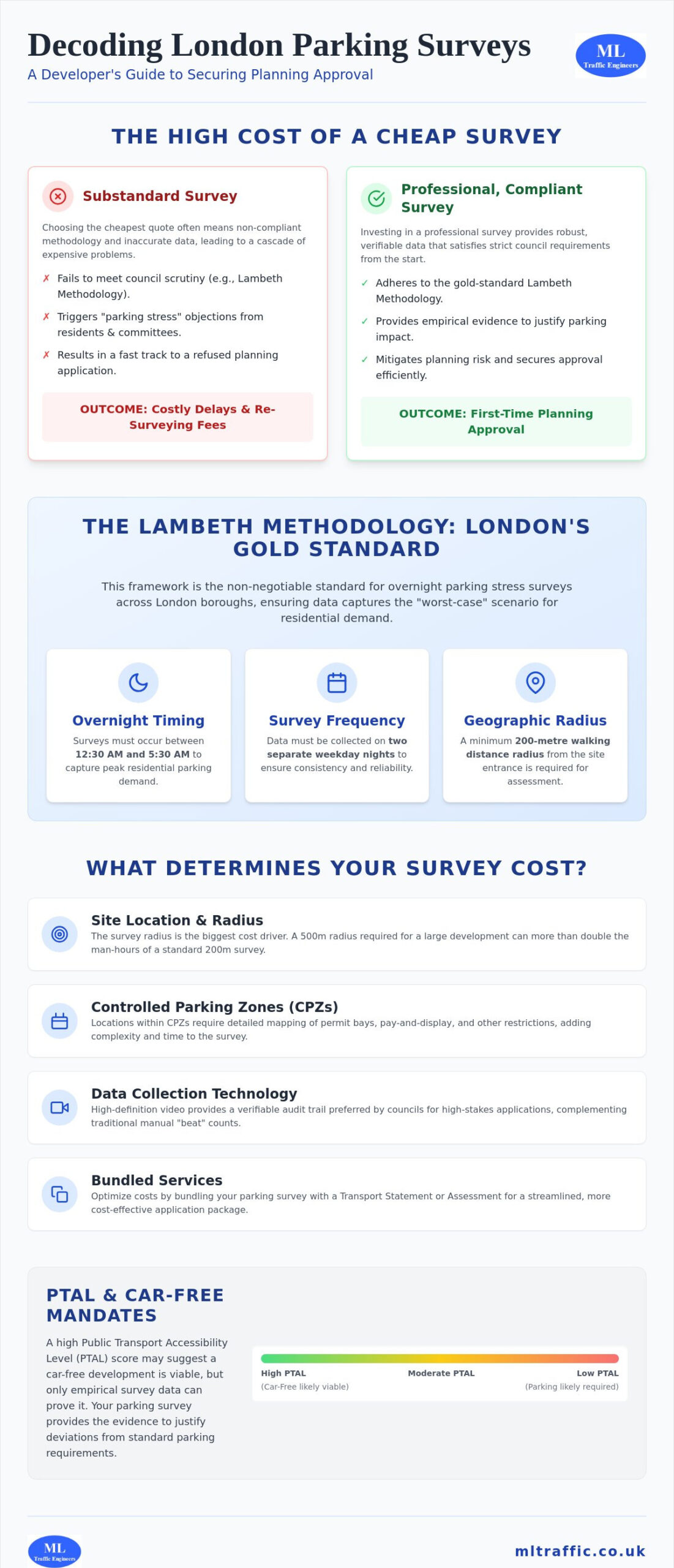
The cheapest parking survey you commission today could become the most expensive line item in your development budget if it fails to meet the Lambeth Methodology. In a city where planning officers scrutinize every meter of curb space, a substandard report is a fast track to a refused application. You’re likely aware that the parking survey cost London firms quote varies wildly, often leaving you to guess which provider understands the intricate regional regulations of boroughs like Lambeth or Kensington and Chelsea.
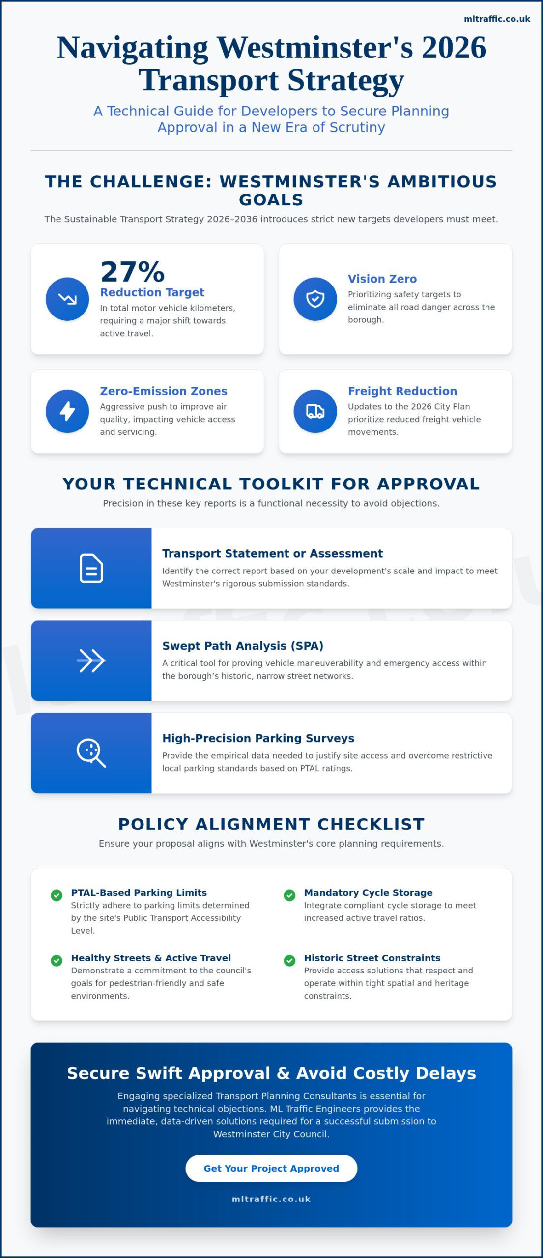
It’s a high-stakes environment where precision isn’t just a preference; it’s a functional necessity for securing planning approval. We understand the pressure of managing transport planning data while trying to avoid hidden fees and regulatory delays. This guide provides a transparent breakdown of how survey costs are calculated in 2026 and how to secure data that passes council scrutiny the first time. We’ll cover everything from PTAL-driven car-free mandates to the specific technical requirements for overnight stress assessments, ensuring your development case remains robust and compliant.
Key Takeaways
- Understand why the Lambeth Methodology is the non-negotiable standard for overnight stress surveys and how it secures your planning approval.
- Identify the key variables, including geographical radius and survey duration, that determine your total parking survey cost London to ensure accurate project budgeting.
- Discover the “First Time Right” principle to avoid expensive re-surveying fees caused by data that fails to meet council scrutiny.
- Learn how bundling parking surveys with Transport Statements can streamline your application process and provide a more cost-effective package.
- Gain insights into PTAL-driven car-free mandates and how empirical data justifies deviations from standard parking requirements.
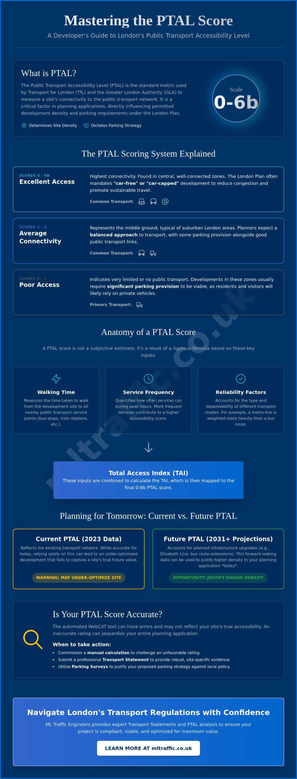
Understanding Parking Survey Requirements for London Planning
A parking stress survey is a technical assessment used to measure the occupancy levels of on-street parking within a specific radius of a proposed development. For projects submitted through the London planning portal, this data acts as empirical evidence to justify the impact of your scheme on the local highway network. When you calculate the overall parking survey cost London developers must account for, the primary value lies in risk mitigation. Boroughs such as Lambeth, Southwark, and Tower Hamlets require professional, verifiable data to ensure that new developments don’t overwhelm existing infrastructure.
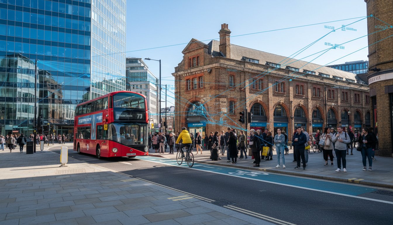
To better understand the logistical challenges of parking in the capital, watch this overview of central London parking dynamics:
Accurate data is the most effective tool to prevent “parking stress” objections from local residents and planning committees. These objections often stem from fears that a new development will strip existing tenants of available spaces. By utilizing advanced parking guidance and information systems and manual counts, we provide a clear picture of current capacity. This technical lexicon is essential when discussing PTAL ratings with Case Officers. A site with a high score might suggest a car-free development is viable, but a detailed survey proves whether that assumption holds true in practice.
When is a Parking Survey Mandatory?
Planning departments typically trigger the requirement for a professional survey in several specific scenarios:
- New residential schemes with zero or limited on-site parking.
- Change of use applications, such as converting an office block into residential flats.
- Developments in areas with high existing parking occupancy.
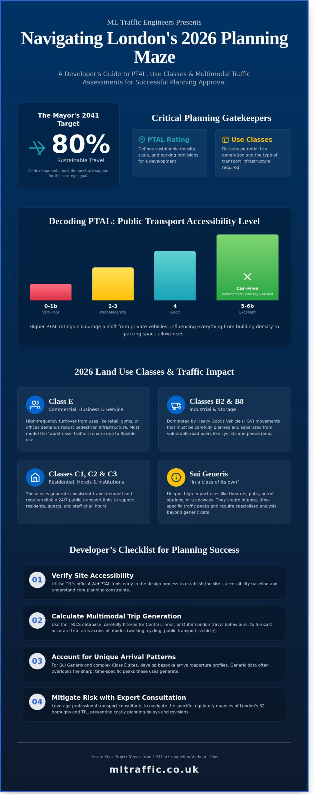
The Role of the Lambeth Methodology
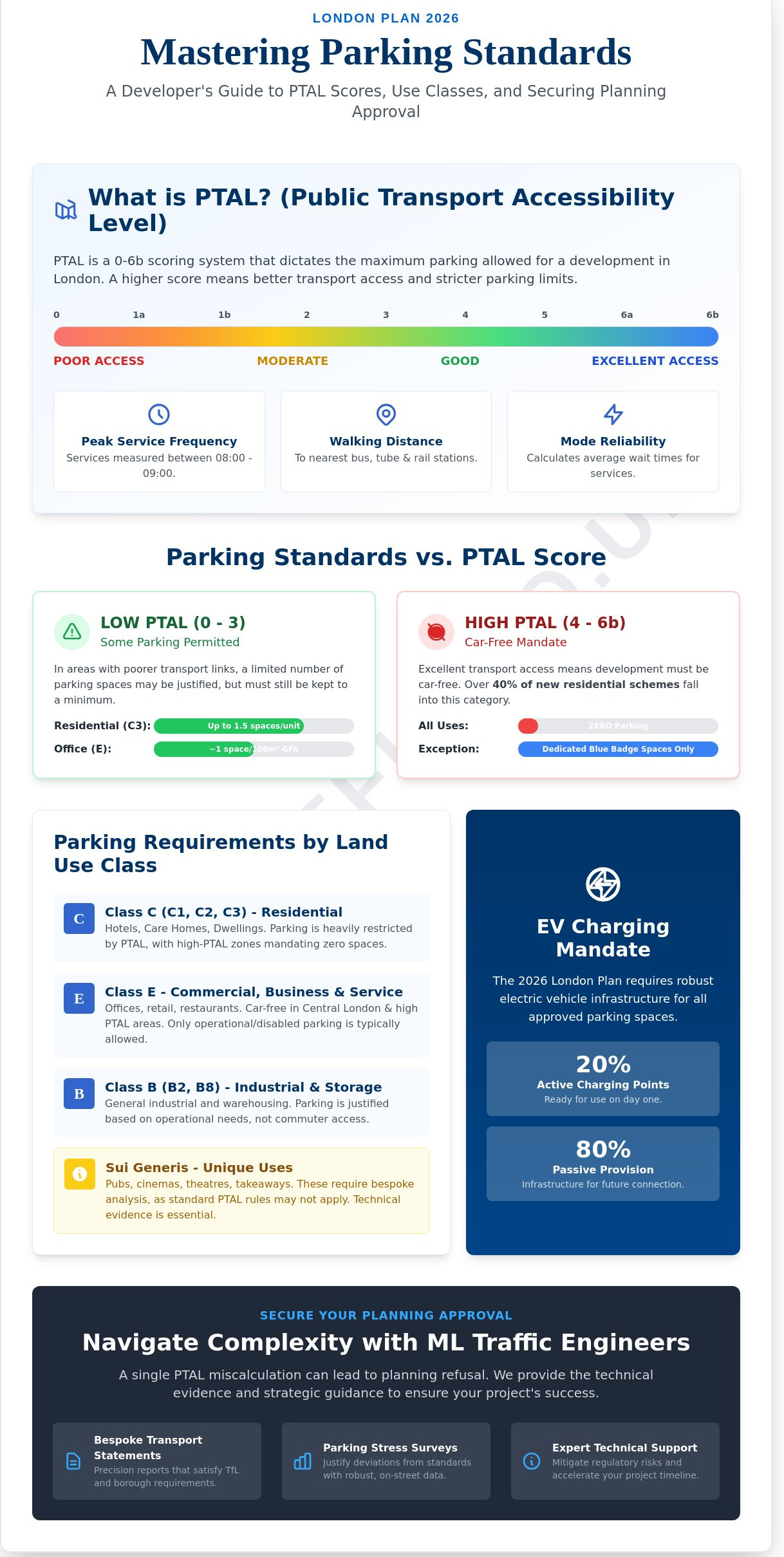
The Lambeth Methodology has become the industry gold standard across the capital. This specific framework ensures that data is collected during the period of highest residential demand. Surveys must occur on two separate weekday nights between 12:30 AM and 5:30 AM. This timing captures the “worst-case” scenario for parking stress. Additionally, the methodology requires a 200-metre walking distance radius from the site entrance. Adhering to these strict parameters is why the parking survey cost London projects require can vary; the precision of the data directly influences the speed of your planning success.
Key Factors Influencing Parking Survey Costs in London
Understanding the variables behind a parking survey cost London quote is vital for accurate project budgeting. While some providers offer flat rates, professional transport planners calculate fees based on the specific logistical demands of the site. A survey in Mayfair involves different regulatory hurdles and data density requirements than a scheme in a quieter outer borough. The primary value of a professional survey isn’t just the data collection itself; it’s the mitigation of planning risk through adherence to strict council standards.
Site Location and Radius
The radius requested by the Case Officer is the most significant cost driver. A standard 200-metre walking distance radius is common for residential sites, but complex or larger developments may require a 500-metre assessment. This larger area significantly increases the surveyor man-hours required for data collection. Furthermore, locations within Controlled Parking Zones (CPZs) require more detailed reporting. Surveyors must identify and map permit-holder bays, pay-and-display areas, and double yellow lines to ensure the Highway Authority has a complete picture of available capacity.
Data Collection Technology
Modern surveys utilize a mix of manual “beat” counts and high-definition video collection. While manual counts are traditional, video data provides a verifiable audit trail that councils often prefer for high-stakes applications. Integrating Swept Path Analysis alongside your parking data can offer a more comprehensive view of site viability. Choosing “cheap” manual counts without a digital backup can lead to data challenges during the consultation period, potentially forcing a costly re-survey if the Highway Authority questions the accuracy of the findings.
Survey frequency also impacts the final bill. Residential applications typically require two separate overnight counts following the Lambeth Parking Survey Methodology. If your site includes commercial elements, the council might demand additional weekend or afternoon beats to capture varied peak demand periods. Each extra visit increases the on-site time and the subsequent data processing requirements. Boroughs like Southwark or Tower Hamlets often have unique reporting formats that require specialized technical input to satisfy their specific planning policies.
If you’re facing a tight planning deadline, express reporting fees may apply to fast-track the analysis through a technical team. It’s always more cost-effective to get the data right the first time rather than responding to a request for further information (RFI) mid-application. For a precise breakdown tailored to your specific site, you can consult with our technical specialists to ensure your survey meets all borough-specific requirements without unnecessary overspending.
Methodology Matters: Lambeth vs. Custom Parking Beat Surveys
Selecting the correct methodology is a functional necessity to ensure your data withstands the scrutiny of a Highway Authority. While a standard occupancy survey might suffice for basic assessments, the Lambeth Method is the industry-standard requirement for London residential developments in 2026. This distinction is critical because commissioning the wrong type of data collection will inevitably inflate your overall parking survey cost London budget through re-submission fees and project delays. Precision at the inception phase prevents the logistical pressure of responding to council objections later in the planning cycle.
Residential vs. Commercial Survey Costs
Residential planning applications prioritize overnight stress data. We focus on identifying the availability of resident permit bays and unrestricted curb space between 00:30 and 05:30. These surveys are typically more expensive because they require specialized nocturnal data collection over two separate weeknights. This captures the peak demand when residents are most likely to be at home, providing a “worst-case” scenario for the council. Accuracy here is non-negotiable for securing approval in high-density boroughs.
Commercial and retail applications utilize “Parking Beat” surveys. These assessments track turnover and stay duration throughout the business day rather than overnight occupancy. We monitor short-stay bays and loading areas to prove that high-frequency vehicle movements won’t disrupt local traffic flow. Mixed-use developments often require a hybrid approach. This combines overnight stress counts with daytime beats, leading to a more complex and costly technical report. However, this comprehensive data is vital for sites in low PTAL areas where parking demand is highly variable and parking survey cost London estimates must account for multiple site visits.
Choosing the Right Survey for Your Planning Application
Before commissioning any work, consult with a transport planning consultant to review your project’s Scoping Opinion. This document, issued by the local council, defines the exact parameters required for your application. Reading it correctly prevents you from paying for data that the Case Officer doesn’t actually need. For example, if a borough only requires a 200-metre radius, paying for a 500-metre assessment is an unnecessary drain on your resources and time.
Timing is another critical factor in survey precision. We ensure that data collection doesn’t conflict with school holidays, local festivals, or major roadworks. Surveys conducted during these “atypical” periods are frequently rejected by councils like Southwark or Lambeth. Our team manages the full project lifecycle, from initial scheduling to final reporting, to ensure the data remains robust and representative of standard conditions. This proactive approach ensures your survey passes the first time, maintaining the integrity of your development case.
How to Optimise Your Survey Budget for 2026 Applications
The most significant drain on a parking survey cost London budget is the hidden expense of a re-survey. This often occurs when a low-cost provider ignores borough-specific snapshot times or fails to account for temporary site conditions. We operate on the “First Time Right” principle. By ensuring every data point meets the exact requirements of the Case Officer from the inception phase, you avoid the logistical pressure of responding to a request for further information (RFI) mid-application. Precision is a functional necessity, not a luxury.
One of the most effective ways to reduce your total expenditure is by bundling services. Combining your parking data collection with Transport Statements allows for a unified technical approach. This reduces administrative overhead and often triggers a package discount. Early engagement is equally vital. Booking your survey 4 to 6 weeks in advance allows our team to schedule data collection during optimal windows, helping you avoid the express fees associated with “rush” planning deadlines. Providing clear, high-resolution site plans at the start further streamlines the process.
Avoiding Common Planning Refusals
Planning officers reject substandard data without hesitation. You must ensure your surveyor accounts for suspended bays, active construction works, or temporary road closures that might artificially inflate parking stress. We also strictly adhere to the “neutral month” rule in transport planning. This means we avoid data collection during school holidays or major seasonal events when traffic patterns are atypical. Overlooking these regional nuances leads to immediate refusal, effectively doubling your parking survey cost London investment when you are forced to start over.
The Value of Expert Analysis
Raw data is just a collection of numbers; councils actually buy the professional interpretation of that data. A well-justified Transport Assessment can save thousands in Section 106 contributions by proving a development’s impact is minimal. Our technical team leverages existing data from the TRICS database to supplement on-site counts, creating a robust evidence base that manual counts cannot achieve alone. This authoritative approach reduces regulatory friction and supports your development case with empirical evidence.
To secure a transparent and precise quote for your next London development, consult with our technical specialists today.
Expert Parking Survey Services by ML Traffic Engineers UK
ML Traffic Engineers UK provides a comprehensive, fully-managed service that removes the regulatory pressure from developers and architects. While your design team might collaborate with Structural Glass Design Ltd on high-specification architectural features, our technical team manages the full lifecycle of the survey, from initial scoping to the final technical report, ensuring every submission aligns with the latest 2026 planning requirements. We understand that a parking survey cost London quote represents more than just data collection; it’s a strategic investment in the viability of your project. Precision is our functional necessity, and we take pride in delivering data that withstands the most rigorous council scrutiny.
We maintain an unwavering commitment to meeting the specific standards of all 32 London Boroughs. Whether your project is in a high-density area requiring the Lambeth Method or an outer borough with bespoke reporting needs, our data remains beyond reproach. We don’t just provide raw numbers. ML Traffic Engineers UK integrates these findings into detailed Transport Statements and Travel Plans, creating a cohesive narrative that supports your development case. This all-encompassing approach ensures that the Highway Authority receives a complete, professional package that minimizes the risk of costly delays.
Why Developers Choose ML Traffic Engineers UK
With over a decade of experience navigating the capital’s complex planning system, we’ve developed a reputation for unwavering reliability. ML Traffic Engineers UK takes pride in our ability to pre-agree survey methodologies directly with Highway Officers before any on-site work begins. This proactive communication eliminates the uncertainty that often leads to application refusal. For projects facing critical deadlines, we offer fast-track reporting capabilities. Our technical authority allows us to deliver precise, audit-ready data with the urgency your schedule demands. We act as a dependable partner that understands intricate regional regulations so you don’t have to.
Get Your Tailored Quote Today
Securing a transparent, fixed-fee proposal is a straightforward process. Once you provide your site plans and project details, we conduct an initial assessment to determine the necessary geographical scope and timing. ML Traffic Engineers UK promises professional integrity and full regulatory compliance in every report we produce. We view our role as a vital partner in your development team, ensuring that technical data serves as a bridge to planning success rather than a barrier. Our team is ready to provide the precision and technical support your 2026 application requires.
To secure the data you need for your next project, contact ML Traffic Engineers UK for a professional parking survey quote. We offer the reliability and technical expertise needed to ensure your parking survey cost London investment delivers a successful planning outcome.
Secure Your Planning Approval with Precise Data
Securing planning approval in 2026 requires a technical evidence base that meets the strict standards of the Highway Authority. We’ve explored how the Lambeth Methodology serves as the gold standard for residential schemes and why early engagement is the most effective way to manage your parking survey cost London budget. Precision at the inception phase prevents the logistical pressure of responding to council objections later. Utilizing professional data interpretation ensures your application remains robust against scrutiny and resident objections.
With over 10 years of experience navigating the London planning system, ML Traffic Engineers UK understands the intricate regional regulations of all 32 boroughs. We’re specialists in the Lambeth Methodology and provide the technical authority needed to support your development case. ML Traffic Engineers UK handles the full project lifecycle so you don’t have to worry about regulatory friction. Our reports are designed to pass council review the first time, maintaining the momentum of your construction program.
Get a Fixed-Fee Parking Survey Quote from ML Traffic Engineers UK
Your development deserves data that stands up to the highest standards. We’re ready to help you move from planning to execution with confidence and professional integrity. Once planning is secured, developers often look to specialists like scottpatternedconcrete.co.uk to implement high-quality decorative concrete finishes for the project’s external infrastructure.
Frequently Asked Questions
How much does a typical parking survey cost in London?
A parking survey cost London developers face is determined by the project’s specific logistical requirements rather than a flat fee. Factors such as the total number of streets included in the survey radius and the frequency of data collection beats directly influence the final quote. A more complex site requiring weekend and weekday assessments will involve higher technical overhead than a standard overnight count.
What is the Lambeth Method for parking surveys?
The Lambeth Methodology is the industry standard for assessing overnight parking stress in London. It requires data collection on two separate weekday nights between 00:30 and 05:30 within a 200-metre walking distance of the development site. This framework captures peak residential demand to provide a worst-case scenario for planning officers, ensuring the data is robust and representative.
Do I need a parking survey for a small residential conversion?
Yes, councils often require professional data for conversions that increase the number of units or change the property’s use class. If the development offers limited on-site parking, a survey proves that the surrounding streets can accommodate the additional demand without creating excessive stress for existing residents. This data is vital for securing approval in high-density boroughs where curb space is at a premium.
Can I use a survey from a nearby development to save on costs?
No, planning departments typically reject secondary data because parking stress is highly site-specific and time-sensitive. A survey must reflect the current conditions of the exact streets surrounding your specific project. Using outdated or proxy data increases the risk of planning refusal and will likely lead to higher long-term expenses if the council demands a fresh assessment mid-application.
How long does it take to receive the final parking survey report?
A standard technical report is usually delivered within 5 to 10 working days following the completion of on-site data collection. This timeline allows for rigorous data processing and quality assurance to ensure the report meets all borough-specific requirements. While it’s tempting to rush the process, this period is necessary for technical analysis to ensure the final parking survey cost London investment results in a compliant submission.
Which London boroughs require the Lambeth methodology?
Most London boroughs, including Lambeth, Southwark, Wandsworth, and Tower Hamlets, adopt the Lambeth Methodology as their default requirement. While some councils have minor variations in their reporting formats, adhering to this standard ensures the highest level of technical compliance across the capital’s planning portal. We pre-agree these methodologies with Highway Officers to avoid any regulatory friction during the consultation period.
Are parking surveys required during school holidays?
No, surveys conducted during school holidays are generally rejected by planning authorities as they represent atypical traffic and parking conditions. We schedule data collection during neutral months to ensure the findings are representative of standard occupancy levels. This proactive scheduling prevents the need for a costly and time-consuming re-survey that could delay your project’s inception.
What happens if the parking survey shows high stress levels?
High stress levels don’t necessarily lead to application refusal if the data is paired with a robust mitigation strategy. We use technical findings to support car-free development cases or justify alternative transport measures, such as permit-free legal agreements. These strategies satisfy council concerns by proving the development won’t worsen existing conditions, even in areas where on-street capacity is limited.

Disclaimer
The content on mltraffic.co.uk, including all technical articles, guides, and resources, is provided for general informational and educational purposes only. It is not intended to constitute professional advice in traffic engineering, transportation planning, development approvals, or any other technical or legal field.
While ML Traffic Engineers makes every reasonable effort to ensure the accuracy, completeness, and timeliness of the information published, we do not provide any warranties or representations (express or implied) regarding its reliability, suitability, or availability for any particular purpose. Any reliance you place on the content is strictly at your own risk.
In no event shall ML Traffic Engineers, its directors, employees, authors, or affiliates be liable for any direct, indirect, incidental, special, consequential, or punitive damages (including, without limitation, loss of profits, data, or business opportunities) arising out of or in connection with the use of, or inability to use, any information provided on this website.
The articles and guides on this site are not a substitute for engaging a qualified, professional traffic engineer to assess your specific project requirements. For tailored advice, compliance assessments, or traffic engineering services, please contact a competent professional.
This disclaimer may be updated from time to time without notice. By accessing or using this website, you agree to be bound by the most current version of this disclaimer.