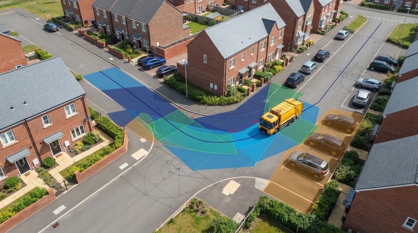
A refuse vehicle can fit on a drawing and still fail to follow the proposed collection route. Swept path analysis for refuse collection strategy tests whether the nominated vehicle can enter, manoeuvre through the layout, reach the collection point and leave, rather than relying on a turning area that only looks adequate on plan.
Resolving access conflicts late can mean costly layout changes and unclear planning evidence. This guide explains how to test vehicle movements against a site’s collection arrangements, what the analysis can demonstrate and where its limits lie. The aim is to turn movement findings into practical design decisions while access, parking and public realm proposals can still be coordinated.
We’ll cover vehicle selection, entry and exit routes, turning areas, reversing and potential conflicts with parking or pedestrian routes. Vehicle geometry also needs to be considered alongside relevant local authority collection requirements. Swept path drawings provide technical evidence of manoeuvrability, but they do not establish that a collection authority will accept the arrangements. Clear, project-specific findings help teams coordinate access design with supporting planning information.
Key Takeaways
- Set clear collection assumptions before testing, including the route, stopping position and onward movement through the site.
- Use a representative refuse vehicle whose dimensions and turning characteristics match the project assumptions.
- Apply swept path analysis for refuse collection strategy to compare layout options consistently and identify access constraints early.
- Review turning areas alongside parking and pedestrian movement to understand the practical trade-offs between access options.
- Provide current site plans, levels and access details to produce clear swept path drawings that inform design coordination and planning evidence.
Why refuse collection strategy needs swept path analysis
A refuse vehicle’s route through a development is part of the site’s operating plan, not a detail to resolve after the buildings and public realm are fixed. Swept path analysis for refuse collection strategy uses vehicle-tracking drawings to assess whether a selected vehicle can follow the intended route through a proposed layout. It shows how the vehicle turns and where its wheels and body travel in relation to the design.
Collection arrangements affect the space needed at several points: the entrance, internal route, turning area, collection point and exit. A layout may allow entry but leave no practical way to turn or continue forward. A stopping position may obstruct circulation, or place the vehicle away from where waste is presented. Testing the complete movement early can expose these conflicts while design changes remain possible.
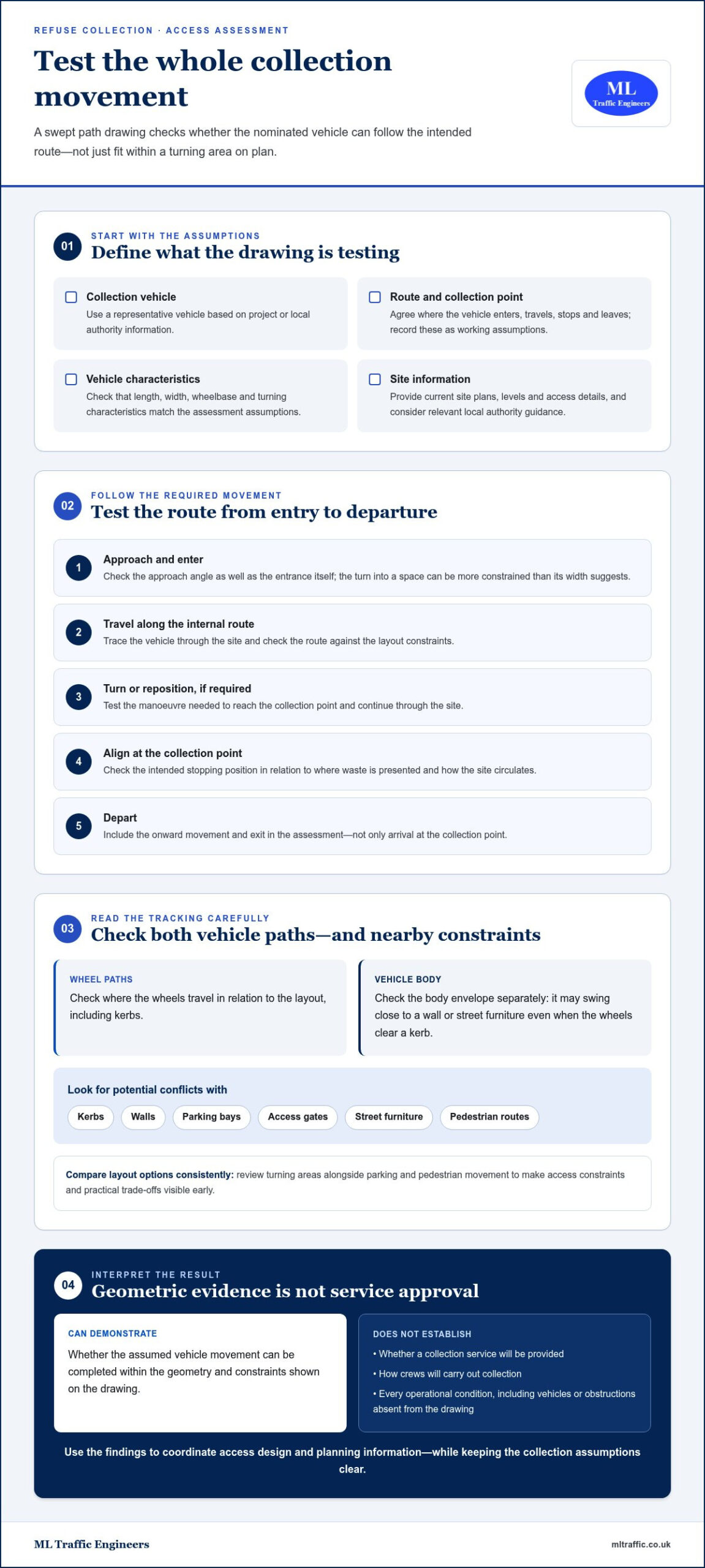
Vehicle-tracking software represents the vehicle’s movement against a site plan. For background on the concept and its development, see AutoTrack, a vehicle swept path analysis software. The output is evidence of geometric manoeuvrability, but it does not assess every operational condition or determine whether a collection service will be provided. A swept path demonstrates whether a vehicle can manoeuvre within the geometry shown; it does not confirm the collection service arrangements.
What refuse collection strategy means for a development
A collection strategy sets out the assumptions that shape vehicle access: the type of vehicle considered, the route it is expected to take and the intended collection point. Those assumptions connect waste presentation and storage with the site’s access design. If the vehicle is expected to stop elsewhere or follow a different route, the layout may need to be tested again.
Requirements vary with local authority guidance and the circumstances of the site. A constrained urban plot, for example, may have different access limitations from a more open development. Coordinating the route and collection point with the layout team early helps reveal issues such as a tight entrance, a turning area affected by parking or a collection point that interrupts pedestrian movement.
What swept path analysis can, and cannot, demonstrate
Vehicle tracking shows the path followed by the wheels and the space occupied by the vehicle body as it moves through a proposed layout. It can highlight potential conflicts with kerbs, walls, parking bays and access gates, and show whether the assumed manoeuvre can be completed without crossing the constraints shown. The result depends on using vehicle dimensions and turning characteristics that reflect the project assumptions.
A successful drawing is not, by itself, proof that every collection requirement has been met. It does not establish service provision, confirm how crews will carry out collection or account for every condition that could affect operations, such as vehicles or obstructions absent from the drawing. ML Traffic Engineers UK’s swept path analysis for development access can communicate manoeuvrability constraints as technical evidence for design coordination and planning information.
How refuse vehicle swept path analysis tests site access
A useful assessment follows a defined sequence: establish the collection assumptions, select a representative vehicle, test the required movements and review any conflicts shown on the layout. This gives the design team a clear basis for deciding whether the proposed access works for the vehicle and route being assessed.
Start with project information and relevant local authority guidance. Agree the intended collection vehicle, route and collection point as working assumptions rather than inferring them from a generic vehicle template. Collection arrangements can also change over time. For example, UK government guidance on waste collection services covers household service requirements in England, including weekly food waste collections from March 2026. Those arrangements may affect how a development plans waste presentation and access.
Select the vehicle and movements to test
Use project or local authority information to identify the vehicle the assessment should represent. Its length, width, wheelbase and turning characteristics influence whether it can pass through an entrance, negotiate a bend, reach the collection point and continue to the exit. Record these assumptions so the drawing can be reviewed against the intended operation.
A tracking vehicle is a representative assessment model, not a guarantee of the exact vehicle that will serve the site. Check that the model and project assumptions are appropriate before stating vehicle specifications. ML Traffic Engineers’ AutoTURN swept path guide explains how vehicle tracking can support access assessment.
Test the movements the layout actually requires: approach and entry, travel along the internal route, turning or repositioning where needed, alignment at the collection point, and departure. An entrance may appear wide enough when considered alone, yet the approach angle could make the turn into it difficult. Testing the full sequence helps expose that relationship.
Read the tracking drawing for conflicts
A tracking drawing can show both the vehicle body envelope and the paths followed by its wheels. These require separate checks: the wheels may clear a kerb while the body swings close to a wall or street furniture. Review the full movement against kerbs, building edges, access gates and parking bays, along with any parked vehicles or other fixed features represented on the plan.
- Check entry and exit movements, including the approach angle and space needed to turn.
- Look for body overhang or wheel paths that cross kerbs, parking areas or pedestrian space.
- Confirm the collection position allows the vehicle to align with the intended route onward.
Use the findings to identify where the layout may need adjustment, such as moving a parking bay, revising a gate position or changing the route. This is technical evidence of the movement tested, not confirmation of collection service or operational acceptance. For project-specific swept path analysis from ML Traffic Engineers, the assessment can help communicate access constraints as the development design progresses.
Compare refuse access options before fixing the site layout
One tracking line can show that a vehicle completes a particular manoeuvre. It cannot, on its own, prove that the whole refuse layout works. The route, stopping position, turning space and relationship with pedestrians all matter. Comparing options while the site plan is still flexible helps reveal which arrangement best fits the development and its collection assumptions.
For a fair comparison, test each feasible layout with the same representative vehicle and consistent assumptions about the route and collection point. Otherwise, a change in vehicle or operating scenario can make one option appear easier simply because it was assessed on different terms. Swept path analysis for refuse collection strategy is most useful when it supports a clear design decision, not just a pass-or-fail line on a drawing.
Compare on-site collection with alternative arrangements
With on-site collection, the vehicle enters the development, follows an internal route to its stopping position, then turns or exits. An alternative may place the collection point outside the site, avoiding internal vehicle movements but creating a different interface with pedestrians and the highway. Neither arrangement is automatically preferable. Feasibility depends on the development, the surrounding street and relevant local authority requirements.
Compare the practical consequences: how much space the route and turning area take, whether the vehicle’s position affects pedestrian movement, and whether a proposed external collection point creates constraints on the highway. Treat any alternative as a project-specific option, not a general rule for Greater London or elsewhere.
Resolve tight urban and constrained-site conditions
On a constrained plot, parked cars can reduce usable street width, while narrow approaches and limited turning space can affect how the vehicle reaches the site. A drawing that assumes an unobstructed approach may not represent the conditions the design needs to address. Make assumptions about parking and access conditions explicit, then compare layouts on the same basis.
Greater London, Manchester and Birmingham each contain varied site and street contexts. A solution that suits one location cannot be treated as a universal collection arrangement across those cities, let alone the whole UK. Test the specific access geometry and collection assumptions for each proposal.
A compact comparison table can make the design decision easier to communicate. Record four items for each option:
- Option: on-site route or proposed alternative.
- Manoeuvre: entry, turning, stopping or exit being assessed.
- Conflict: the constraint identified, such as a tight turn, parking overlap or pedestrian interface.
- Design response: the change considered, such as revising the route or adjusting the collection position.
This format helps the project team connect the tracking outcome with its design consequence. It also keeps comparisons focused on the same vehicle and collection assumptions, making trade-offs easier to discuss before the layout is fixed.
Use a practical workflow to coordinate refuse access design
Refuse access coordination works best as a design task with clear inputs, recorded assumptions and an agreed process for resolving conflicts. Swept path analysis for refuse collection strategy can help the project team test a proposed layout, but its value depends on the quality and currency of the information used. A route assessed against an outdated plan may no longer match the design under review.
Early tracking can reveal vehicle-layout conflicts while the design can still respond, before those issues reach a planning submission. Use a straightforward workflow: gather current drawings, agree the vehicle and collection assumptions, test the intended movements, record conflicts, then revise and reassess the layout. Note drawing versions so everyone can see which design the analysis relates to.
Prepare the information needed for a useful assessment
Bring together the current site layout, access geometry and relevant servicing details, including the proposed collection point and internal route. Site levels help the team coordinate access design with the wider layout, while vehicle assessment relies on agreed vehicle and movement assumptions. Identify gaps or changes, such as a revised gate position, and record them as items for the project team to resolve rather than treating them as settled inputs.
Before tracking begins, make the key assumptions easy to find:
- Drawings: current site plan showing buildings, kerbs, parking, gates and relevant street features.
- Access information: entrance arrangement, internal route, turning areas and proposed stopping position.
- Collection assumptions: representative vehicle, route and collection point, informed by project and local authority information.
- Open items: missing or changing details that could affect the assessment or require a design decision.
Once movements have been tested, record each unresolved conflict alongside its location, effect on the manoeuvre and proposed design response. If a change moves a kerb or parking bay, for example, note the revised drawing and whether the affected movement needs to be checked again. This creates a usable design record and gives the project team a clear basis for interpreting the tracking plan.
Coordinate findings with planning and transport material
A clearly presented tracking drawing can support wider transport evidence for a development, including a transport statement or transport assessment where relevant. Label the vehicle and manoeuvre, show the route and identify important constraints. State the drawing reference and key assumptions so readers can understand what was tested and how the findings relate to the proposed access design.
ML Traffic Engineers’ swept path analysis guide provides related context on preparing vehicle-tracking evidence for planning applications. The swept path analysis service supports project-specific refuse access assessment and technical drawings. Clear coordination helps the design and planning material present consistent information, without implying that a drawing alone determines collection acceptance.
Commission refuse collection swept path analysis for your project
A project-specific assessment starts with a clear picture of the development and the access question that needs answering. Useful information includes the current site layout, access geometry, relevant levels, proposed collection point and intended route. Project information or local authority guidance about the expected refuse vehicle can help define the assessment assumptions.
ML Traffic Engineers provides swept path analysis to assess vehicle manoeuvrability within development layouts. The work can identify where a proposed route, turning area or collection position may conflict with the design, giving the project team technical evidence to consider before the layout is finalised. Its value is clarity: what movement was tested, what the drawing shows and which constraints may need a design response.
What a project-specific assessment should make clear
The assessment should identify the representative vehicle and the movements tested, such as entering, turning, positioning for collection and exiting. It should show the relevant layout constraints and make clear where the vehicle envelope or wheel path approaches or crosses them. If a conflict appears, the drawing can inform a proposed change and indicate whether the revised layout needs further review.
Project assumptions matter. If the route, collection point or access design changes, the assessment may need updating to reflect the current proposal. Swept path analysis is technical evidence of the vehicle movements modelled. It does not, by itself, secure planning permission or confirm that a collection service will be accepted.
Move from access uncertainty to a defined next step
The planning stage and drawing status help shape the assessment. Early design information can identify potential constraints while options remain open; a more developed layout can be assessed to produce evidence that relates directly to the proposal. Clear, current plans and a concise description of the access question give the assessment a practical project focus.
ML Traffic Engineers combines swept path analysis with transport planning experience, including the preparation of transport statements and transport assessments for planning applications. The swept path analysis service overview explains how this technical work fits within the consultancy’s transport planning services.
To define the assessment, bring together the current site plan, intended vehicle and route assumptions, and any known access constraints. ML Traffic Engineers provides project-specific swept path analysis for development layouts.
Take the next step towards a coordinated access design
Use the current design stage to turn refuse access assumptions into a clear assessment brief. Identify the site plan to be tested, the intended vehicle and route, the collection position, and any access constraints the team needs to resolve. Keeping these inputs aligned gives the project team a practical basis for reviewing options and deciding what to refine next.
For developments in Greater London, Manchester, Birmingham, the West Midlands, Liverpool, Surrey, East Sussex, West Sussex, Hampshire, Berkshire and Buckinghamshire, ML Traffic Engineers provides swept path analysis and prepares transport statements and transport assessments. Project-specific swept path analysis for refuse collection strategy can contribute technical evidence to development access assessment, while collection arrangements and planning decisions remain part of their relevant processes.
Bring your current layout and access question into the next design discussion. Discuss swept path analysis for your development with ML Traffic Engineers and take a clear, evidence-led step towards a layout that works for the project.
Frequently Asked Questions
What is swept path analysis for refuse collection?
It’s a technical assessment of how a refuse vehicle is expected to move through a proposed site layout. The drawing can help answer practical design questions, such as whether a vehicle can approach a collection point without its body or wheels overlapping nearby site features. For swept path analysis for refuse collection strategy, the vehicle model and manoeuvres should reflect the project’s stated assumptions, not an unverified generic template.
Can swept path analysis prove a refuse vehicle can access a site?
It can show whether the vehicle modelled can complete the movements drawn within the geometry provided. The conclusion applies to those assumptions and the plan assessed. If an entrance position changes after tracking, for example, the earlier drawing may no longer reflect the proposed access. The assessment does not establish how the site will operate under every condition, such as temporary obstructions or vehicles parked outside the layout shown.
What information is needed for refuse vehicle tracking?
Provide a current site plan with the entrance, internal routes, buildings, kerbs, parking and proposed collection point identified. Access dimensions and relevant level information help coordinate the assessment with the design. Include the intended vehicle and movements, plus any project or local authority information that informs those assumptions. If a layout detail is still changing, flag it so the team can distinguish an agreed input from an item that needs resolution.
Does swept path analysis guarantee that a local authority will collect waste?
No. A tracking drawing assesses vehicle movement against the layout; it does not confirm that a collection service will be provided or that the authority accepts every operational arrangement. Requirements can vary across authorities in Greater London, Manchester, Birmingham, the West Midlands and Liverpool, as well as in Surrey, East Sussex, West Sussex, Hampshire, Berkshire and Buckinghamshire. Treat local collection guidance and vehicle tracking as related, but distinct, parts of project planning.
When should refuse collection swept path analysis be carried out?
Carry it out while access and site layout options are still being developed, then revisit it if a design change affects the route or manoeuvre. Moving a gate, altering parking or relocating the collection point may change the vehicle movement being assessed. Early assessment gives the team time to consider design responses before plans are finalised for a planning submission.
What does a refuse vehicle swept path drawing show?
A swept path drawing typically illustrates the modelled vehicle movement over a site plan. It can show the route followed by the wheels and the space occupied by the vehicle body during a manoeuvre, helping readers interpret clearances around features such as walls, kerbs and gates. The drawing should identify the vehicle and movement assessed so the project team can understand what the tracking demonstrates and which assumptions it depends on.

Disclaimer
The content on mltraffic.co.uk, including all technical articles, guides, and resources, is provided for general informational and educational purposes only. It is not intended to constitute professional advice in traffic engineering, transportation planning, development approvals, or any other technical or legal field.
While ML Traffic Engineers makes every reasonable effort to ensure the accuracy, completeness, and timeliness of the information published, we do not provide any warranties or representations (express or implied) regarding its reliability, suitability, or availability for any particular purpose. Any reliance you place on the content is strictly at your own risk.
In no event shall ML Traffic Engineers, its directors, employees, authors, or affiliates be liable for any direct, indirect, incidental, special, consequential, or punitive damages (including, without limitation, loss of profits, data, or business opportunities) arising out of or in connection with the use of, or inability to use, any information provided on this website.
The articles and guides on this site are not a substitute for engaging a qualified, professional traffic engineer to assess your specific project requirements. For tailored advice, compliance assessments, or traffic engineering services, please contact a competent professional.
This disclaimer may be updated from time to time without notice. By accessing or using this website, you agree to be bound by the most current version of this disclaimer.