Tag: refuse vehicle access

  • Swept Path Analysis for UK Refuse Collection Strategy

    Swept Path Analysis for UK Refuse Collection Strategy

    A refuse vehicle can fit on a drawing and still fail to follow the proposed collection route. Swept path analysis for refuse collection strategy tests whether the nominated vehicle can enter, manoeuvre through the layout, reach the collection point and leave, rather than relying on a turning area that only looks adequate on plan.

    Resolving access conflicts late can mean costly layout changes and unclear planning evidence. This guide explains how to test vehicle movements against a site’s collection arrangements, what the analysis can demonstrate and where its limits lie. The aim is to turn movement findings into practical design decisions while access, parking and public realm proposals can still be coordinated.

    We’ll cover vehicle selection, entry and exit routes, turning areas, reversing and potential conflicts with parking or pedestrian routes. Vehicle geometry also needs to be considered alongside relevant local authority collection requirements. Swept path drawings provide technical evidence of manoeuvrability, but they do not establish that a collection authority will accept the arrangements. Clear, project-specific findings help teams coordinate access design with supporting planning information.

    Key Takeaways

    • Set clear collection assumptions before testing, including the route, stopping position and onward movement through the site.
    • Use a representative refuse vehicle whose dimensions and turning characteristics match the project assumptions.
    • Apply swept path analysis for refuse collection strategy to compare layout options consistently and identify access constraints early.
    • Review turning areas alongside parking and pedestrian movement to understand the practical trade-offs between access options.
    • Provide current site plans, levels and access details to produce clear swept path drawings that inform design coordination and planning evidence.

    Why refuse collection strategy needs swept path analysis

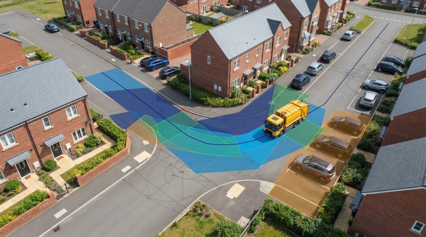
    A refuse vehicle’s route through a development is part of the site’s operating plan, not a detail to resolve after the buildings and public realm are fixed. Swept path analysis for refuse collection strategy uses vehicle-tracking drawings to assess whether a selected vehicle can follow the intended route through a proposed layout. It shows how the vehicle turns and where its wheels and body travel in relation to the design.

    Collection arrangements affect the space needed at several points: the entrance, internal route, turning area, collection point and exit. A layout may allow entry but leave no practical way to turn or continue forward. A stopping position may obstruct circulation, or place the vehicle away from where waste is presented. Testing the complete movement early can expose these conflicts while design changes remain possible.

    Vehicle-tracking software represents the vehicle’s movement against a site plan. For background on the concept and its development, see AutoTrack, a vehicle swept path analysis software. The output is evidence of geometric manoeuvrability, but it does not assess every operational condition or determine whether a collection service will be provided. A swept path demonstrates whether a vehicle can manoeuvre within the geometry shown; it does not confirm the collection service arrangements.

    What refuse collection strategy means for a development

    A collection strategy sets out the assumptions that shape vehicle access: the type of vehicle considered, the route it is expected to take and the intended collection point. Those assumptions connect waste presentation and storage with the site’s access design. If the vehicle is expected to stop elsewhere or follow a different route, the layout may need to be tested again.

    Requirements vary with local authority guidance and the circumstances of the site. A constrained urban plot, for example, may have different access limitations from a more open development. Coordinating the route and collection point with the layout team early helps reveal issues such as a tight entrance, a turning area affected by parking or a collection point that interrupts pedestrian movement.

    What swept path analysis can, and cannot, demonstrate

    Vehicle tracking shows the path followed by the wheels and the space occupied by the vehicle body as it moves through a proposed layout. It can highlight potential conflicts with kerbs, walls, parking bays and access gates, and show whether the assumed manoeuvre can be completed without crossing the constraints shown. The result depends on using vehicle dimensions and turning characteristics that reflect the project assumptions.

    A successful drawing is not, by itself, proof that every collection requirement has been met. It does not establish service provision, confirm how crews will carry out collection or account for every condition that could affect operations, such as vehicles or obstructions absent from the drawing. ML Traffic Engineers UK’s swept path analysis for development access can communicate manoeuvrability constraints as technical evidence for design coordination and planning information.

    How refuse vehicle swept path analysis tests site access

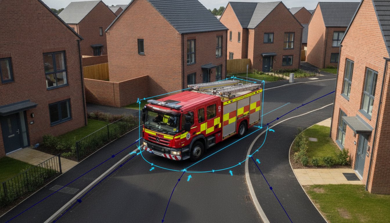
    A useful assessment follows a defined sequence: establish the collection assumptions, select a representative vehicle, test the required movements and review any conflicts shown on the layout. This gives the design team a clear basis for deciding whether the proposed access works for the vehicle and route being assessed.

    Start with project information and relevant local authority guidance. Agree the intended collection vehicle, route and collection point as working assumptions rather than inferring them from a generic vehicle template. Collection arrangements can also change over time. For example, UK government guidance on waste collection services covers household service requirements in England, including weekly food waste collections from March 2026. Those arrangements may affect how a development plans waste presentation and access.

    Select the vehicle and movements to test

    Use project or local authority information to identify the vehicle the assessment should represent. Its length, width, wheelbase and turning characteristics influence whether it can pass through an entrance, negotiate a bend, reach the collection point and continue to the exit. Record these assumptions so the drawing can be reviewed against the intended operation.

    A tracking vehicle is a representative assessment model, not a guarantee of the exact vehicle that will serve the site. Check that the model and project assumptions are appropriate before stating vehicle specifications. ML Traffic Engineers’ AutoTURN swept path guide explains how vehicle tracking can support access assessment.

    Test the movements the layout actually requires: approach and entry, travel along the internal route, turning or repositioning where needed, alignment at the collection point, and departure. An entrance may appear wide enough when considered alone, yet the approach angle could make the turn into it difficult. Testing the full sequence helps expose that relationship.

    Read the tracking drawing for conflicts

    A tracking drawing can show both the vehicle body envelope and the paths followed by its wheels. These require separate checks: the wheels may clear a kerb while the body swings close to a wall or street furniture. Review the full movement against kerbs, building edges, access gates and parking bays, along with any parked vehicles or other fixed features represented on the plan.

    • Check entry and exit movements, including the approach angle and space needed to turn.
    • Look for body overhang or wheel paths that cross kerbs, parking areas or pedestrian space.
    • Confirm the collection position allows the vehicle to align with the intended route onward.

    Use the findings to identify where the layout may need adjustment, such as moving a parking bay, revising a gate position or changing the route. This is technical evidence of the movement tested, not confirmation of collection service or operational acceptance. For project-specific swept path analysis from ML Traffic Engineers, the assessment can help communicate access constraints as the development design progresses.

    Compare refuse access options before fixing the site layout

    One tracking line can show that a vehicle completes a particular manoeuvre. It cannot, on its own, prove that the whole refuse layout works. The route, stopping position, turning space and relationship with pedestrians all matter. Comparing options while the site plan is still flexible helps reveal which arrangement best fits the development and its collection assumptions.

    For a fair comparison, test each feasible layout with the same representative vehicle and consistent assumptions about the route and collection point. Otherwise, a change in vehicle or operating scenario can make one option appear easier simply because it was assessed on different terms. Swept path analysis for refuse collection strategy is most useful when it supports a clear design decision, not just a pass-or-fail line on a drawing.

    Compare on-site collection with alternative arrangements

    With on-site collection, the vehicle enters the development, follows an internal route to its stopping position, then turns or exits. An alternative may place the collection point outside the site, avoiding internal vehicle movements but creating a different interface with pedestrians and the highway. Neither arrangement is automatically preferable. Feasibility depends on the development, the surrounding street and relevant local authority requirements.

    Compare the practical consequences: how much space the route and turning area take, whether the vehicle’s position affects pedestrian movement, and whether a proposed external collection point creates constraints on the highway. Treat any alternative as a project-specific option, not a general rule for Greater London or elsewhere.

    Resolve tight urban and constrained-site conditions

    On a constrained plot, parked cars can reduce usable street width, while narrow approaches and limited turning space can affect how the vehicle reaches the site. A drawing that assumes an unobstructed approach may not represent the conditions the design needs to address. Make assumptions about parking and access conditions explicit, then compare layouts on the same basis.

    Greater London, Manchester and Birmingham each contain varied site and street contexts. A solution that suits one location cannot be treated as a universal collection arrangement across those cities, let alone the whole UK. Test the specific access geometry and collection assumptions for each proposal.

    A compact comparison table can make the design decision easier to communicate. Record four items for each option:

    • Option: on-site route or proposed alternative.
    • Manoeuvre: entry, turning, stopping or exit being assessed.
    • Conflict: the constraint identified, such as a tight turn, parking overlap or pedestrian interface.
    • Design response: the change considered, such as revising the route or adjusting the collection position.

    This format helps the project team connect the tracking outcome with its design consequence. It also keeps comparisons focused on the same vehicle and collection assumptions, making trade-offs easier to discuss before the layout is fixed.
    Swept Path Analysis for UK Refuse Collection Strategy

    Use a practical workflow to coordinate refuse access design

    Refuse access coordination works best as a design task with clear inputs, recorded assumptions and an agreed process for resolving conflicts. Swept path analysis for refuse collection strategy can help the project team test a proposed layout, but its value depends on the quality and currency of the information used. A route assessed against an outdated plan may no longer match the design under review.

    Early tracking can reveal vehicle-layout conflicts while the design can still respond, before those issues reach a planning submission. Use a straightforward workflow: gather current drawings, agree the vehicle and collection assumptions, test the intended movements, record conflicts, then revise and reassess the layout. Note drawing versions so everyone can see which design the analysis relates to.

    Prepare the information needed for a useful assessment

    Bring together the current site layout, access geometry and relevant servicing details, including the proposed collection point and internal route. Site levels help the team coordinate access design with the wider layout, while vehicle assessment relies on agreed vehicle and movement assumptions. Identify gaps or changes, such as a revised gate position, and record them as items for the project team to resolve rather than treating them as settled inputs.

    Before tracking begins, make the key assumptions easy to find:

    • Drawings: current site plan showing buildings, kerbs, parking, gates and relevant street features.
    • Access information: entrance arrangement, internal route, turning areas and proposed stopping position.
    • Collection assumptions: representative vehicle, route and collection point, informed by project and local authority information.
    • Open items: missing or changing details that could affect the assessment or require a design decision.

    Once movements have been tested, record each unresolved conflict alongside its location, effect on the manoeuvre and proposed design response. If a change moves a kerb or parking bay, for example, note the revised drawing and whether the affected movement needs to be checked again. This creates a usable design record and gives the project team a clear basis for interpreting the tracking plan.

    Coordinate findings with planning and transport material

    A clearly presented tracking drawing can support wider transport evidence for a development, including a transport statement or transport assessment where relevant. Label the vehicle and manoeuvre, show the route and identify important constraints. State the drawing reference and key assumptions so readers can understand what was tested and how the findings relate to the proposed access design.

    ML Traffic Engineers’ swept path analysis guide provides related context on preparing vehicle-tracking evidence for planning applications. The swept path analysis service supports project-specific refuse access assessment and technical drawings. Clear coordination helps the design and planning material present consistent information, without implying that a drawing alone determines collection acceptance.

    Commission refuse collection swept path analysis for your project

    A project-specific assessment starts with a clear picture of the development and the access question that needs answering. Useful information includes the current site layout, access geometry, relevant levels, proposed collection point and intended route. Project information or local authority guidance about the expected refuse vehicle can help define the assessment assumptions.

    ML Traffic Engineers provides swept path analysis to assess vehicle manoeuvrability within development layouts. The work can identify where a proposed route, turning area or collection position may conflict with the design, giving the project team technical evidence to consider before the layout is finalised. Its value is clarity: what movement was tested, what the drawing shows and which constraints may need a design response.

    What a project-specific assessment should make clear

    The assessment should identify the representative vehicle and the movements tested, such as entering, turning, positioning for collection and exiting. It should show the relevant layout constraints and make clear where the vehicle envelope or wheel path approaches or crosses them. If a conflict appears, the drawing can inform a proposed change and indicate whether the revised layout needs further review.

    Project assumptions matter. If the route, collection point or access design changes, the assessment may need updating to reflect the current proposal. Swept path analysis is technical evidence of the vehicle movements modelled. It does not, by itself, secure planning permission or confirm that a collection service will be accepted.

    Move from access uncertainty to a defined next step

    The planning stage and drawing status help shape the assessment. Early design information can identify potential constraints while options remain open; a more developed layout can be assessed to produce evidence that relates directly to the proposal. Clear, current plans and a concise description of the access question give the assessment a practical project focus.

    ML Traffic Engineers combines swept path analysis with transport planning experience, including the preparation of transport statements and transport assessments for planning applications. The swept path analysis service overview explains how this technical work fits within the consultancy’s transport planning services.

    To define the assessment, bring together the current site plan, intended vehicle and route assumptions, and any known access constraints. ML Traffic Engineers provides project-specific swept path analysis for development layouts.

    Take the next step towards a coordinated access design

    Use the current design stage to turn refuse access assumptions into a clear assessment brief. Identify the site plan to be tested, the intended vehicle and route, the collection position, and any access constraints the team needs to resolve. Keeping these inputs aligned gives the project team a practical basis for reviewing options and deciding what to refine next.

    For developments in Greater London, Manchester, Birmingham, the West Midlands, Liverpool, Surrey, East Sussex, West Sussex, Hampshire, Berkshire and Buckinghamshire, ML Traffic Engineers provides swept path analysis and prepares transport statements and transport assessments. Project-specific swept path analysis for refuse collection strategy can contribute technical evidence to development access assessment, while collection arrangements and planning decisions remain part of their relevant processes.

    Bring your current layout and access question into the next design discussion. Discuss swept path analysis for your development with ML Traffic Engineers and take a clear, evidence-led step towards a layout that works for the project.

    Frequently Asked Questions

    What is swept path analysis for refuse collection?

    It’s a technical assessment of how a refuse vehicle is expected to move through a proposed site layout. The drawing can help answer practical design questions, such as whether a vehicle can approach a collection point without its body or wheels overlapping nearby site features. For swept path analysis for refuse collection strategy, the vehicle model and manoeuvres should reflect the project’s stated assumptions, not an unverified generic template.

    Can swept path analysis prove a refuse vehicle can access a site?

    It can show whether the vehicle modelled can complete the movements drawn within the geometry provided. The conclusion applies to those assumptions and the plan assessed. If an entrance position changes after tracking, for example, the earlier drawing may no longer reflect the proposed access. The assessment does not establish how the site will operate under every condition, such as temporary obstructions or vehicles parked outside the layout shown.

    What information is needed for refuse vehicle tracking?

    Provide a current site plan with the entrance, internal routes, buildings, kerbs, parking and proposed collection point identified. Access dimensions and relevant level information help coordinate the assessment with the design. Include the intended vehicle and movements, plus any project or local authority information that informs those assumptions. If a layout detail is still changing, flag it so the team can distinguish an agreed input from an item that needs resolution.

    Does swept path analysis guarantee that a local authority will collect waste?

    No. A tracking drawing assesses vehicle movement against the layout; it does not confirm that a collection service will be provided or that the authority accepts every operational arrangement. Requirements can vary across authorities in Greater London, Manchester, Birmingham, the West Midlands and Liverpool, as well as in Surrey, East Sussex, West Sussex, Hampshire, Berkshire and Buckinghamshire. Treat local collection guidance and vehicle tracking as related, but distinct, parts of project planning.

    When should refuse collection swept path analysis be carried out?

    Carry it out while access and site layout options are still being developed, then revisit it if a design change affects the route or manoeuvre. Moving a gate, altering parking or relocating the collection point may change the vehicle movement being assessed. Early assessment gives the team time to consider design responses before plans are finalised for a planning submission.

    What does a refuse vehicle swept path drawing show?

    A swept path drawing typically illustrates the modelled vehicle movement over a site plan. It can show the route followed by the wheels and the space occupied by the vehicle body during a manoeuvre, helping readers interpret clearances around features such as walls, kerbs and gates. The drawing should identify the vehicle and movement assessed so the project team can understand what the tracking demonstrates and which assumptions it depends on.

    Michael Lee

    Article by

    Michael Lee

    Transport planner with over 35 years' experience.

    Disclaimer

    The content on mltraffic.co.uk, including all technical articles, guides, and resources, is provided for general informational and educational purposes only. It is not intended to constitute professional advice in traffic engineering, transportation planning, development approvals, or any other technical or legal field.
    While ML Traffic Engineers makes every reasonable effort to ensure the accuracy, completeness, and timeliness of the information published, we do not provide any warranties or representations (express or implied) regarding its reliability, suitability, or availability for any particular purpose. Any reliance you place on the content is strictly at your own risk.
    In no event shall ML Traffic Engineers, its directors, employees, authors, or affiliates be liable for any direct, indirect, incidental, special, consequential, or punitive damages (including, without limitation, loss of profits, data, or business opportunities) arising out of or in connection with the use of, or inability to use, any information provided on this website.
    The articles and guides on this site are not a substitute for engaging a qualified, professional traffic engineer to assess your specific project requirements. For tailored advice, compliance assessments, or traffic engineering services, please contact a competent professional.
    This disclaimer may be updated from time to time without notice. By accessing or using this website, you agree to be bound by the most current version of this disclaimer.
  • Swept Path Analysis for Planning Applications: The 2026 Developer’s Guide

    Swept Path Analysis for Planning Applications: The 2026 Developer’s Guide

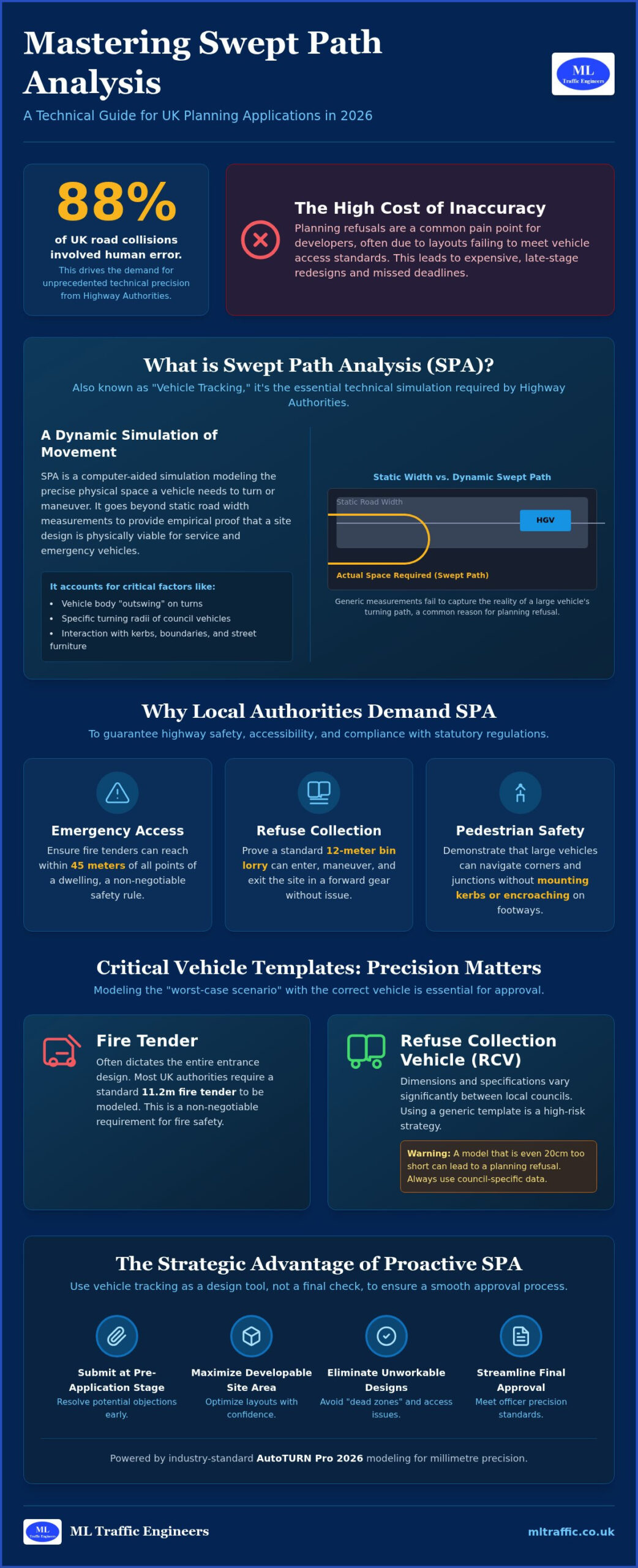
    Did you know that human error contributed to 88% of road collisions in Great Britain according to recent data? This single statistic is driving Local Highway Authorities to demand unprecedented technical precision in 2026. For developers, a simple site layout is no longer enough to win approval. You’ve likely faced the frustration of a planning refusal because a council officer deemed your refuse vehicle tracking unworkable or non-compliant with the latest fire safety standards. It’s a common pain point that leads to expensive, late-stage design revisions and missed project deadlines.

    Securing a successful outcome requires a proactive approach to swept path analysis for planning applications. We understand the pressure of meeting the September 30, 2026, amendments to Approved Document B while balancing local council preferences for bin lorry dimensions. This guide provides the technical clarity you need to master vehicle tracking and avoid site design errors. You’ll learn how to utilize the latest AutoTURN Pro 2026 modeling to confirm access for fire tenders and heavy goods vehicles. We will walk you through the essential steps to produce planning-ready drawings that ensure smooth communication with the Highway Authority from inception to completion.

    Key Takeaways

    • Understand why swept path analysis for planning applications is the essential technical simulation required by Highway Authorities to prove vehicle maneuverability.
    • Identify the critical vehicle templates, such as refuse collection vehicles and fire tenders, that must be modeled to meet current safety and access regulations.
    • Discover how to use vehicle tracking as a proactive design tool to maximize developable site area while eliminating unworkable layouts and “dead zones.”
    • Learn the strategic advantage of submitting technical drawings at the pre-application stage to resolve potential objections before they lead to a formal refusal.
    • Ensure your technical reports meet the specific precision standards and formatting expected by planning officers to streamline the approval process.

    What is Swept Path Analysis for Planning Applications?

    Swept Path Analysis (SPA) is a computer-aided simulation that models the physical space a vehicle requires to complete a turn or maneuver. In the UK planning system, officers often use the term “Vehicle Tracking” interchangeably with SPA. This process moves beyond static road measurements to provide a dynamic view of how vehicles interact with your site layout. While a road may meet a standard width on paper, it doesn’t account for the “outswing” of a 16.5m articulated HGV or the specific turning radius of a local refuse truck. Relying on generic manual measurements is a risk that often leads to planning refusal.

    A professional swept path analysis for planning applications serves as the technical evidence required to support a Transport Statement or a more detailed Transport Assessment. It provides empirical proof that a site design is physically viable. Without this data, a Highway Authority has no guarantee that service vehicles won’t mount kerbs or become stuck, which typically results in immediate objections from the council.

    The Technology Behind the Analysis

    Precision is the non-negotiable standard for any modern development. We utilize AutoTURN software, which is the industry benchmark for simulating vehicle movements across the UK. By integrating digital vehicle models directly into your CAD site drawings, we achieve millimetre precision. This process requires more than just software; it demands a foundation of accurate Ordnance Survey (OS) mapping to account for existing kerb lines and boundaries. Historically, the evolution of vehicle swept path analysis software has moved from manual overlays to these sophisticated digital twins, allowing us to predict real-world outcomes before a single brick is laid.

    Why Local Authorities Demand SPA

    Local Highway Authorities across England have significantly increased their technical requirements in 2026. Their primary goal is maintaining highway safety and preventing vehicles from mounting pavements, which poses a direct risk to pedestrians. Officers use SPA to verify that your development layout doesn’t impede the flow of existing traffic or cause local congestion. Beyond general traffic, you must meet strict statutory requirements for emergency and service vehicle access. Key requirements include:

    • Emergency Access: Ensuring a fire tender can reach within 45m of all points of a dwelling.
    • Refuse Collection: Proving a 12m bin lorry can enter, turn, and exit the site in a forward gear.
    • Pedestrian Safety: Demonstrating that large vehicles can navigate corners without encroaching on footways.

    If a site layout cannot accommodate the turning circle of these critical vehicles, planning officers will view the scheme as unworkable and unsafe.

    Key Vehicle Templates: From Refuse Trucks to Fire Tenders

    Selecting the correct vehicle profile is the foundation of a robust technical submission. In the context of swept path analysis for planning applications, we focus on “critical vehicles.” These are the largest vehicles expected to visit your site regularly. If your layout accommodates the largest possible vehicle, it’s mathematically certain that smaller cars and vans will also navigate the space safely. We prioritize modeling the worst-case scenario to eliminate any doubt from the Highway Authority’s assessment.

    Many developers make the mistake of using generic vehicle templates found in basic software libraries. This is a high-risk strategy. Local councils across England have specific preferences for refuse collection vehicle (RCV) dimensions, and using a template that is even 20cm too short can lead to a planning refusal. We select the correct vehicle profile based on your specific site location, cross-referencing local authority guidance to ensure the simulation reflects the actual fleet used by the council. For more technical details on these specifications, you can explore our practical guide for planning applications.

    Emergency Vehicle Access Requirements

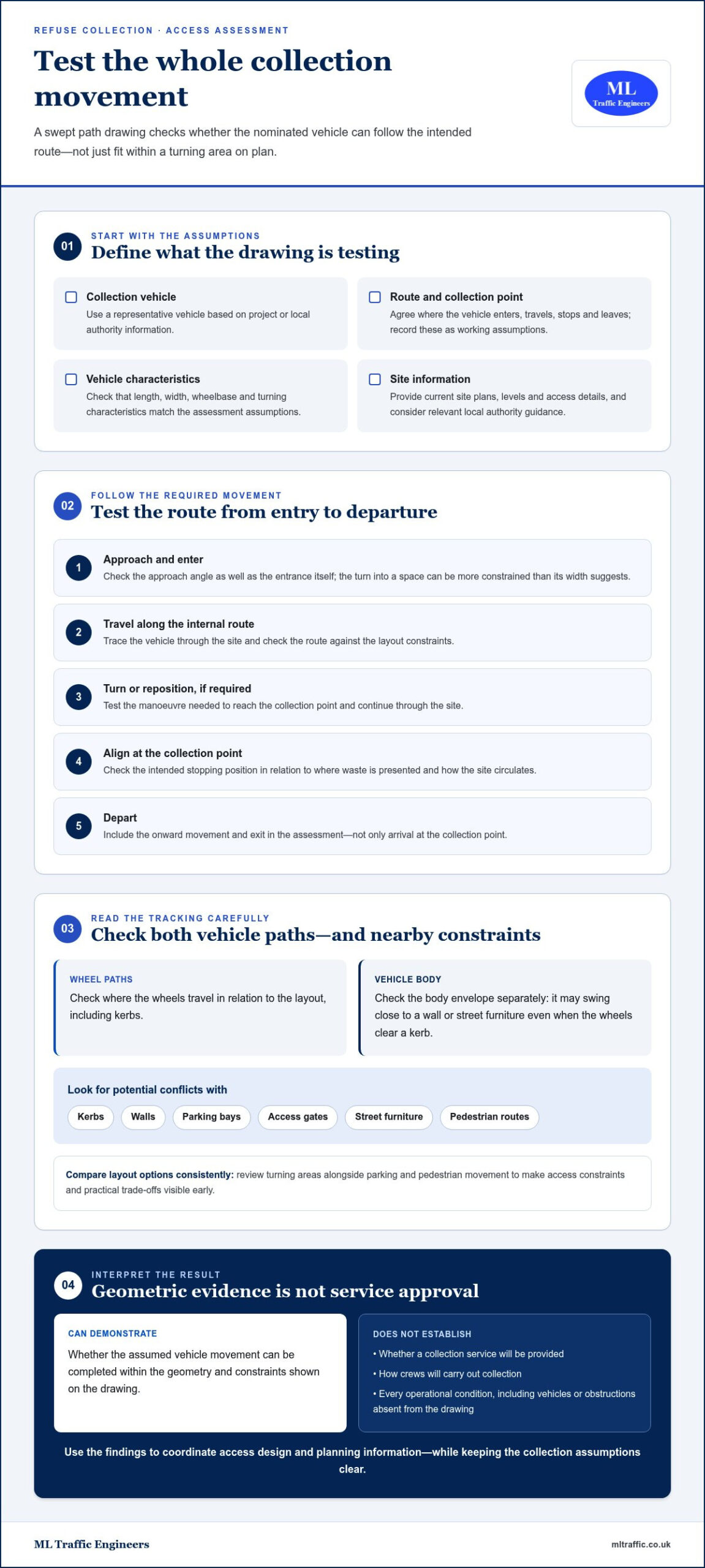
    Fire safety regulations are non-negotiable and often dictate the entire entrance design of a residential development. Most UK authorities require a standard 11.2m fire tender to be modeled. This analysis isn’t just about the turn; it’s about the pump-to-hydrant reach and ensuring the appliance can position itself within 45m of all points within a dwelling. The standard turning circle of a UK fire tender is 16.8 metres. Official resources like the NYC Street Design Manual highlight how these geometric requirements are a global standard for ensuring life safety in urban environments. We model these maneuvers to prove that emergency services can operate without restriction on your site.

    Refuse and Service Vehicle Maneuvers

    Waste management requirements have become more stringent in 2026. We’ve seen a significant shift toward larger 3-axle and 4-axle RCVs as councils aim for higher collection efficiency. A key requirement for planning approval is the “forward gear” rule. Planning officers almost always insist that a bin lorry can enter, turn, and exit the site in a forward gear. This often necessitates a three-point turn within the site boundaries. For mixed-use developments, we also track delivery vans to ensure that loading bays are accessible without blocking the main highway. Our swept path analysis for planning applications provides the visual proof that these essential services won’t cause gridlock or safety hazards.

    Optimising Site Layouts and Access Feasibility

    Balancing parking density with efficient vehicle circulation is a constant challenge for modern developments. We look beyond simple road widths to analyze how visibility splays and turning envelopes interact. It’s vital to ensure that a vehicle’s path doesn’t conflict with pedestrian crossings or site boundaries. When these elements are synchronized, the resulting layout is inherently safer and more likely to receive a positive recommendation from the local Highway Authority. We don’t just provide drawings; we provide the technical confidence that your site works in the real world.

    Urban developments often face significant constraints, such as narrow entrances or historic building lines that cannot be moved. In these high-stakes environments, we use vehicle tracking to prove that site access is feasible even with limited space. We frequently specify “overrun” areas or mounting-strips in modern highway design. These features allow larger vehicles to navigate tight corners while maintaining a narrower road profile for standard traffic. We also demonstrate that two vehicles, such as a car and a van, can safely pass at critical junctions. This prevents potential bottlenecks that would otherwise lead to a planning objection or a “Reason for Refusal.”

    Integrating SPA into the Architectural Workflow

    The most successful projects involve a continuous iteration loop between transport engineers and architects. We work alongside your design team to identify potential flaws before they reach the planning committee. This collaborative approach prevents costly revisions late in the project lifecycle. By integrating our Swept Path Analysis services early, you ensure your architectural vision is grounded in physical reality. We provide the technical evidence to defend your design against scrutiny. This confirms that fire tenders and refuse trucks can operate seamlessly within the proposed layout from the first day of occupation.

    Using swept path analysis for planning applications throughout the project lifecycle provides a significant regulatory advantage. Technical evidence is most effective when used as a proactive communication tool rather than a reactive fix. By integrating vehicle tracking at the earliest stages, you demonstrate to planning officers that your development is grounded in physical reality. This technical transparency builds trust with the Highway Authority and can significantly shorten the determination period for complex sites.

    If a project has previously faced a “Reason for Refusal” based on unworkable layouts or safety concerns, SPA is your most powerful tool for resubmission. It provides the empirical data needed to overturn subjective objections. This technical proof is also a prerequisite for Section 278 (S278) agreements. When your project requires modifications to the existing public highway, the council will demand precise tracking to ensure the new road geometry accommodates standard service vehicles without compromising safety.

    The Pre-Application Phase

    The pre-application stage is the ideal time to open a technical dialogue with the Highway Authority. Presenting professional vehicle tracking early allows you to secure “in principle” support for ambitious access designs. This strategy identifies potential “showstoppers” before you invest in full architectural plans. By addressing the concerns of statutory consultees early, you reduce the risk of a late-stage objection that could derail your entire application. Our experts use this phase to negotiate specific vehicle dimensions, ensuring the final submission aligns perfectly with local requirements.

    Discharging Reserved Matters and Conditions

    Securing outline planning permission is often just the first step. Local authorities frequently attach transport-related conditions that must be discharged before construction begins. We provide the granular detail required for these submissions, often focusing on specific concerns such as construction traffic management or delivery vehicle routing. It’s essential that the final build matches the approved tracking paths exactly. Discrepancies between the approved SPA and the finished site can lead to enforcement action or delays in site adoption. We ensure your technical drawings are robust enough to withstand this scrutiny from inception to completion.

    To ensure your project moves through the planning system without technical delays, contact us to discuss our fully-managed swept path analysis services.

    Swept Path Analysis for Planning Applications: The 2026 Developer’s Guide

    Professional Technical Analysis with ML Traffic Engineers

    ML Traffic Engineers UK brings over a decade of specialized experience to your development team. Founded in 2014, we prioritize precision and regulatory compliance in every report we produce. Our technical team understands that a minor error in vehicle tracking can lead to a major delay in your project timeline. We provide a “ready-to-submit” drawing format that planning officers prefer, which significantly reduces the need for clarification requests. Our expertise spans both London-specific requirements (TfL) and national highway standards across England. We maintain rapid turnaround times because we understand the fast-moving, unpredictable nature of infrastructure maintenance and emergency works; for those requiring safety verification of lifting machinery in these sectors, visit Pulo Compliance Ltd.

    Generalist architectural services often lack the specialized software and regulatory depth required for complex swept path analysis for planning applications. We act as a dependable partner that understands intricate regional regulations so you don’t have to. Our engineers engage in direct communication with Highway Authorities to resolve technical disputes before they escalate. This specialized focus allows us to defend your site layout with technical authority and professional integrity. Beyond vehicle tracking, we offer an all-encompassing, fully-managed service that includes Parking Surveys, Transport Assessments, and Travel Plans. This comprehensive support reduces the logistical pressure on your team from project inception to completion.

    Next Steps for Your Planning Application

    Getting started is a straightforward process designed for efficiency and clarity. To request a quote, we typically require your current site plans in CAD format and a list of the specific vehicle types the council has requested. If you aren’t sure which vehicle templates are required, we advise you based on our extensive database of local authority preferences and the latest 2026 standards. Our consultation process moves logically from an initial review of your layout to the delivery of final, signed-off drawings. We identify potential design flaws early and suggest refinements to ensure your submission is robust.

    We take immense pride in our adherence to industry benchmarks and legislative requirements. Our role is to act as a vital guardian of public safety while ensuring your project remains commercially viable. We are ready to support your application with the technical evidence needed to secure approval and avoid costly site design errors. Contact ML Traffic Engineers UK for a Swept Path Analysis quote today to keep your development on schedule and ensure your site is planning-ready.

    Secure Your Planning Approval with Technical Precision

    Mastering the technical requirements of vehicle tracking is the most reliable way to avoid costly site design errors and planning deadlock. We’ve demonstrated that swept path analysis for planning applications is no longer just a reactive compliance document. It’s a vital tool for maximizing developable land while ensuring public safety. By utilizing advanced AutoTURN precision modeling, you can transform your site layout into a technical drawing that satisfies the strictest Highway Authority requirements.

    Founded in 2014, ML Traffic Engineers UK provides UK-wide planning expertise to help you navigate intricate regional regulations. Our team manages full project lifecycles to ensure your fire tender and refuse truck access paths are indisputable. We reduce the logistical and regulatory pressures on your team so you can focus on the build. Don’t let unworkable layouts or “dead zones” delay your project milestones.

    Get a Professional Swept Path Analysis for Your Project and ensure your development is ready for a successful submission.

    Frequently Asked Questions

    What is the average cost of a swept path analysis for a planning application?

    Costs vary significantly based on the complexity of your project and the number of vehicle profiles required by the council. A single-access residential site requires less modeling than a large-scale logistics hub with multiple HGV loading bays. Getting a tailored quote ensures you only pay for the specific vehicle tracking your local authority demands. This targeted approach prevents overspending on unnecessary simulations while ensuring every statutory requirement is met for your submission.

    Which software is best for swept path analysis in the UK?

    AutoTURN is the industry standard for performing swept path analysis for planning applications across the UK. It provides an extensive library of vehicle templates that align with national standards and specific council fleet dimensions. Most Local Highway Authorities prefer results from this software because it integrates directly with CAD drawings for millimeter precision. Using this recognized platform ensures your technical drawings meet the professional standards expected by planning officers and statutory consultees.

    Does every planning application require vehicle tracking?

    No, vehicle tracking isn’t a universal requirement for every project. It’s typically mandatory for developments that introduce new access points, change internal road layouts, or increase service vehicle demand. Small internal renovations usually don’t need it. However, if your project involves a new residential block or commercial unit, the council will likely request technical proof that fire tenders and refuse trucks can navigate the site safely and exit in a forward gear.

    What happens if my site layout fails the swept path analysis?

    A failed simulation is an opportunity to optimize your design before it reaches the planning committee. If the tracking shows a vehicle hitting a boundary or mounting a kerb, we collaborate with your architects to refine the geometry. This might involve widening a junction, repositioning parking bays, or implementing overrun areas. Identifying these “dead zones” early prevents a formal planning refusal and ensures your final site layout is physically workable.

    Can I do my own swept path analysis using standard CAD tools?

    Performing an accurate analysis is difficult without specialized software and traffic engineering expertise. Standard CAD tools lack the dynamic libraries needed to account for complex vehicle outswing and steering characteristics. Planning officers look for specific professional formatting and technical certification in the reports they review. Submitting an amateur drawing often leads to immediate rejection or technical objections, which can significantly delay your project determination and increase your overall revision costs.

    How long does it take to produce a professional SPA drawing?

    Most professional technical drawings are produced within a few business days once we receive your CAD site plans. The exact timeline depends on the number of maneuvers and vehicle types requested by the Highway Authority. For complex, multi-phase developments, the process may take slightly longer to ensure every junction is thoroughly tested. We prioritize efficient turnaround times to help you meet tight submission deadlines and keep your development project on schedule.

    What vehicle types are most commonly requested by UK councils?

    UK councils most frequently demand tracking for 11.2m fire tenders and 12m refuse collection vehicles. For commercial sites, 16.5m articulated HGVs are the standard for logistics hubs, while 10m rigid trucks are common for retail deliveries. We also model standard 4.8m cars to verify parking bay accessibility. Ensuring your site layout accommodates these specific templates is essential for proving that essential services can operate safely without obstructing the existing public highway.

    Is swept path analysis required for residential driveways?

    Swept path analysis is rarely necessary for a single private driveway. However, it’s often required for shared driveways serving multiple dwellings or sites with narrow access onto busy roads. In these scenarios, the Highway Authority requires proof that a car can turn within the site to enter and exit the highway in a forward gear. This prevents dangerous reversing maneuvers onto the main road, which is a critical factor in maintaining local highway safety.

    Michael Lee

    Article by

    Michael Lee

    Transport planner with over 35 years' experience.

    Disclaimer

    The content on mltraffic.co.uk, including all technical articles, guides, and resources, is provided for general informational and educational purposes only. It is not intended to constitute professional advice in traffic engineering, transportation planning, development approvals, or any other technical or legal field.
    While ML Traffic Engineers makes every reasonable effort to ensure the accuracy, completeness, and timeliness of the information published, we do not provide any warranties or representations (express or implied) regarding its reliability, suitability, or availability for any particular purpose. Any reliance you place on the content is strictly at your own risk.
    In no event shall ML Traffic Engineers, its directors, employees, authors, or affiliates be liable for any direct, indirect, incidental, special, consequential, or punitive damages (including, without limitation, loss of profits, data, or business opportunities) arising out of or in connection with the use of, or inability to use, any information provided on this website.
    The articles and guides on this site are not a substitute for engaging a qualified, professional traffic engineer to assess your specific project requirements. For tailored advice, compliance assessments, or traffic engineering services, please contact a competent professional.
    This disclaimer may be updated from time to time without notice. By accessing or using this website, you agree to be bound by the most current version of this disclaimer.