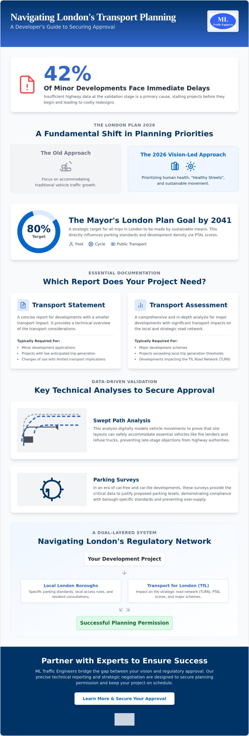
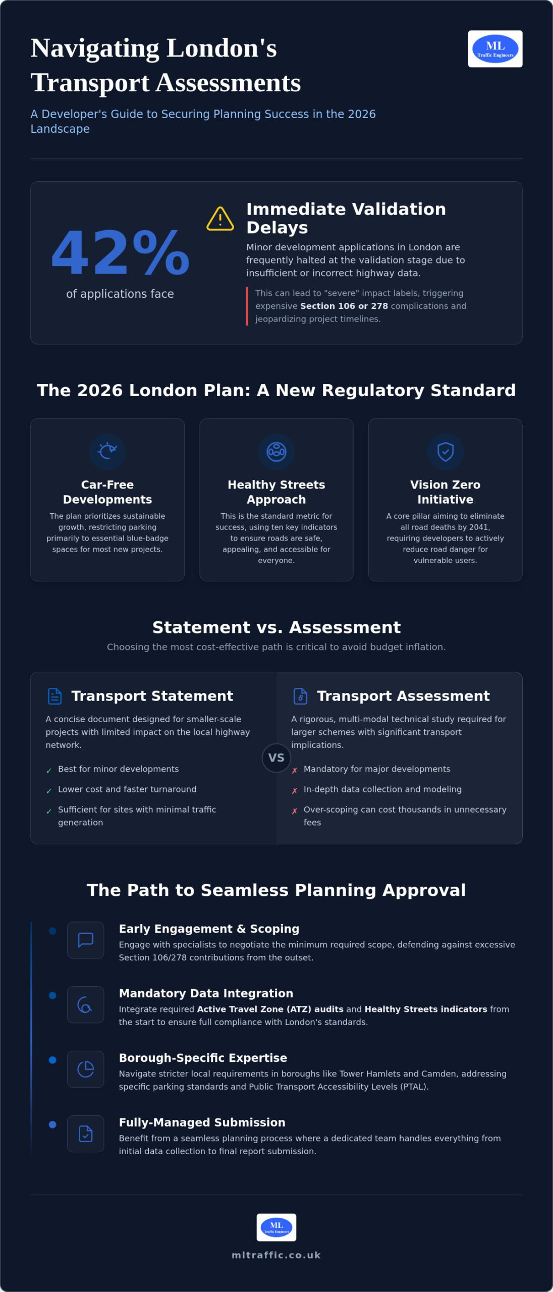
Did you know that 42% of minor development applications in London face immediate delays at the validation stage because of insufficient highway data? Securing an affordable transport assessment London developers can rely on requires more than just finding a low quote. It demands a precise, data-driven approach that anticipates the intense scrutiny of the 2026 regulatory landscape. We understand the pressure to avoid “severe” impact labels that often lead to expensive Section 106 or 278 complications.
You shouldn’t have to choose between a compliant report and a manageable budget. This guide provides the technical clarity you need to secure a TfL-compliant assessment that guarantees planning success while eliminating unnecessary consultancy fees. We will examine the specific thresholds between Transport Statements and Assessments, the latest Healthy Streets indicators, and how to navigate Active Travel Zone requirements to keep your project moving forward without delay.
Key Takeaways
- Understand how the 2026 London Plan prioritizes car-free developments and sustainable growth to ensure your project aligns with current regulatory standards.
- Determine whether your project requires a concise Transport Statement or a full Assessment to avoid overpaying for unnecessary technical data.
- Learn how to secure an affordable transport assessment London authorities will approve by integrating mandatory Active Travel Zone (ATZ) audits and Healthy Streets indicators from the start.
- Reduce the risk of costly Section 106 or 278 complications through early engagement with specialists who understand local borough requirements.
- Discover the benefits of a fully-managed service from ML Traffic Engineers UK that handles everything from data collection to final submission for a seamless planning process.
Understanding Transport Assessments in the 2026 London Planning Landscape
A Transport Assessment (TA) is a detailed technical study that evaluates how a proposed development affects the surrounding infrastructure. It goes beyond simple traffic counts, examining public transport capacity, pedestrian safety, and cyclist accessibility. Because the regulatory environment is so complex, securing an affordable transport assessment London authorities will accept requires a deep understanding of Transportation planning principles. A well-executed TA acts as a bridge between your architectural vision and the city’s strict operational requirements.
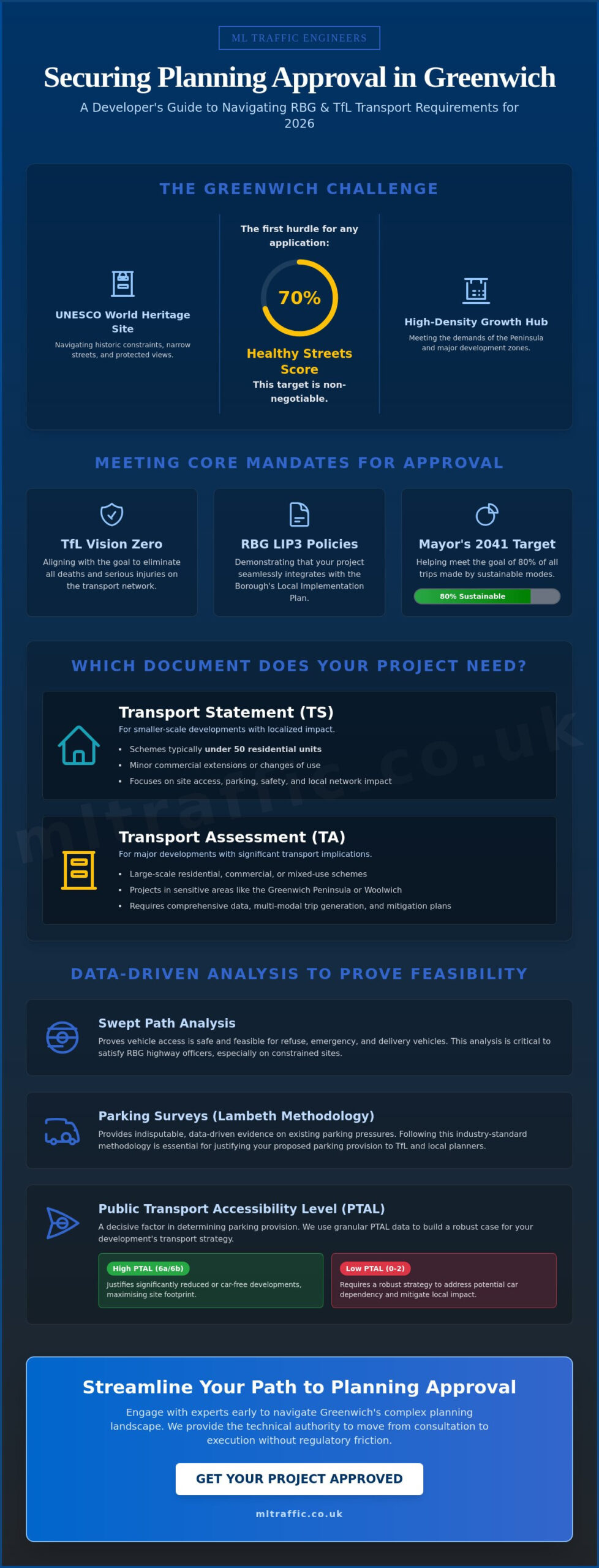
The 2026 London Plan has shifted the focus entirely toward sustainable growth and car-free developments. This means that for most new projects, parking is restricted to essential blue-badge spaces only. The “Healthy Streets” approach is now the standard metric for success. It uses ten specific indicators to ensure roads are safe, shaded, and appealing for everyone. If your report doesn’t demonstrate how your site contributes to these indicators, you risk immediate pushback from council officers.
To understand how these transport policies affect wider city infrastructure, watch this guide from Transport for London:
The Role of the London Plan and Vision Zero
Vision Zero is a core pillar of London’s strategy, aiming to eliminate all road traffic deaths and serious injuries by 2041. This initiative directly impacts how you design site access and loading bays to prevent collisions. There is a heavy emphasis on “Active Travel,” which requires developers to provide robust data on walking and cycling routes within a 20-minute radius. Vision Zero mandates that every planning application in 2026 demonstrates how the development actively reduces road danger for vulnerable users.
Why London Boroughs Require Professional Transport Reporting
Boroughs like Tower Hamlets and Camden have requirements that are significantly stricter than the rest of the UK. They use statutory powers to ensure any “severe” impacts on the highway network are fully mitigated before construction begins. A professional TA doesn’t just check boxes; it proactively defends your project against excessive Section 106 financial contributions by proving your impact is minimal. Navigating borough-specific parking standards and Public Transport Accessibility Levels (PTAL) requires local expertise to avoid validation delays. Working with specialists ensures you get a compliant, affordable transport assessment London councils can validate without demanding costly technical revisions later.
Transport Statement vs. Transport Assessment: Choosing the Most Cost-Effective Path
One of the most frequent causes of budget inflation in London development is the commissioning of an over-scoped technical report. While both documents analyze impact, a Transport Statement is a concise document intended for smaller projects with limited highway implications. In contrast, a full Transport Assessment is a rigorous, multi-modal study required for larger schemes. Selecting the correct path is critical for an affordable transport assessment London project. Securing an affordable transport assessment London developers can trust starts with a technical review of the site’s specific constraints.
Our team at ML Traffic Engineers UK specializes in negotiating with planning officers to determine the absolute minimum scope required to satisfy national planning policy and local borough standards. Choosing a full Assessment when a Statement would suffice can lead to thousands of pounds in unnecessary technical fees. For a deeper look at procurement strategies, refer to our Transport Statement London – A Developer’s Buying Guide. This resource helps you identify where reporting can be streamlined without compromising the quality of the submission.
Thresholds: When Can You Use a Transport Statement?
Regulatory thresholds vary between the 32 London boroughs, but general patterns exist. A Transport Statement is typically sufficient for residential developments under 50 units. Some local authorities may extend this to 80 units if the site has a high Public Transport Accessibility Level (PTAL) rating. For commercial projects, a Statement usually covers retail or office spaces under 1,000 square meters. We also monitor vehicle movement triggers; a Statement is often the standard choice when a development is projected to generate between 30 and 50 vehicle movements during peak hours. If your project sits on the edge of these thresholds, it’s worth getting a technical review of your site constraints before committing to a specific report type.
The Full Transport Assessment: When Is It Non-Negotiable?
Large-scale projects classified as “Developments of Strategic Importance” must undergo a full Transport Assessment and are often referred to Transport for London (TfL). These reports require a comprehensive multi-modal trip generation analysis using the latest TRICS data, adjusted for specific London PTAL ratings. In Central London, any development that generates 50 or more vehicle movements in a single peak hour will almost always trigger the requirement for a full TA. These assessments must also integrate detailed parking management strategies and robust infrastructure mitigation plans to satisfy the London Plan’s sustainability goals.
Essential Components of a London TA: Healthy Streets and ATZ
Securing an affordable transport assessment London authorities will approve requires a move beyond simple traffic counts. In 2026, the technical focus is on the “Healthy Streets” approach. This methodology uses ten specific indicators to evaluate how a development interacts with the public realm. These indicators include “easy to cross,” “shade and shelter,” and “places to stop and rest.” Failure to demonstrate compliance with these metrics is a primary cause of planning refusal in boroughs like Islington and Southwark. We integrate these indicators into our reporting from the outset to ensure your project meets the Mayor’s transport goals without requiring multiple revisions.
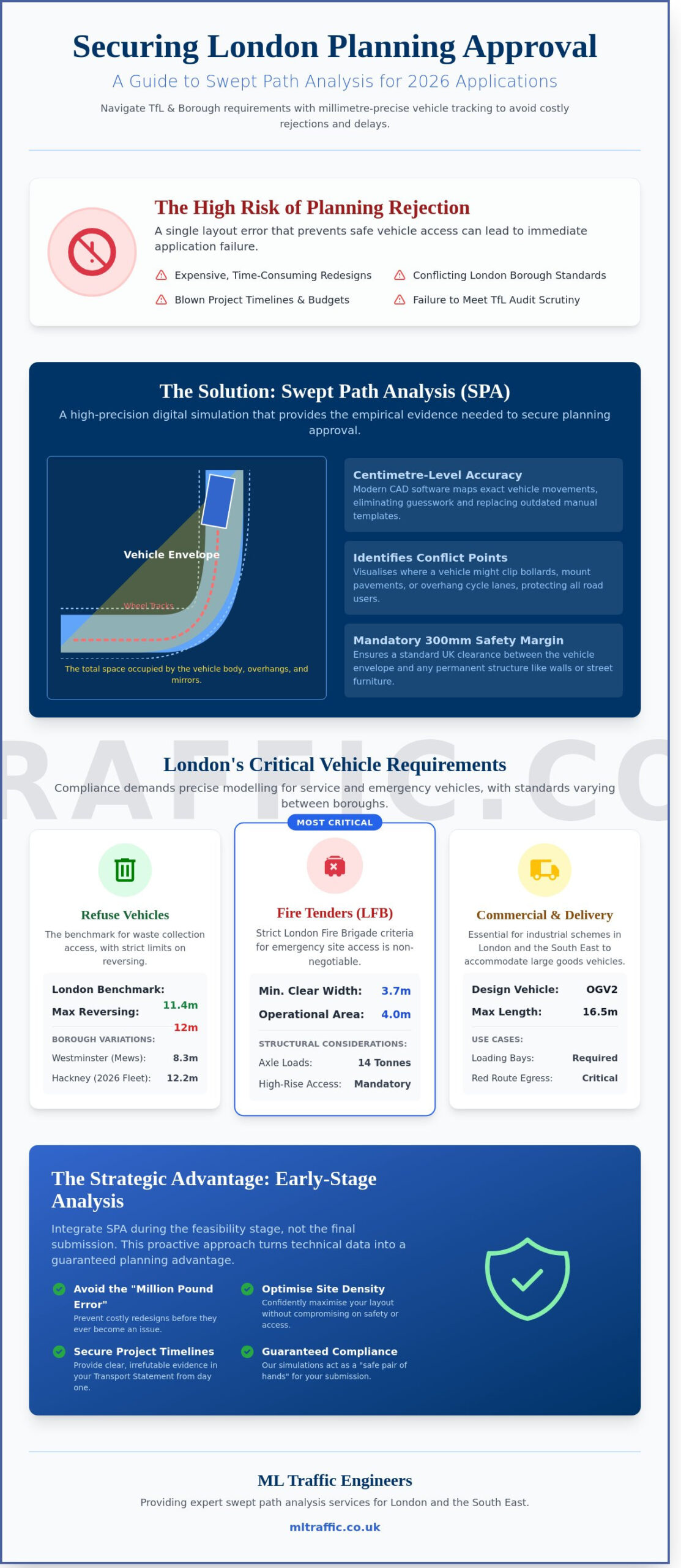
Accurate data collection is the foundation of a successful submission. This includes localized pedestrian and cycle counts and an analysis of current public transport capacity. Precision in this data prevents councils from requesting additional, expensive surveys mid-application. We also utilize Swept Path Analysis to confirm that site access is physically feasible for heavy goods vehicles and emergency services. By validating these movements early, we eliminate the risk of late-stage design changes that can inflate your project budget.
Conducting an Active Travel Zone (ATZ) Audit
The Active Travel Zone assessment is a mandatory supplement for most London projects. It requires a systematic audit of the walking and cycling environment within a 20-minute radius of the site. We follow a logical, sequential process to complete this:
- Mapping Destinations: We identify key local attractors such as schools, healthcare facilities, and major transport hubs.
- Route Analysis: Our experts walk the primary routes, collecting photographic evidence of pavement widths, lighting quality, and crossing safety.
- Gap Identification: We highlight specific deficiencies in the existing network, such as missing dropped kerbs or inadequate cycle lanes.
Integrating Travel Plans for Planning Approval
A Travel Plan is often required alongside a TA to promote sustainable transport choices. This document outlines long-term management strategies to encourage residents or employees to walk, cycle, or use public transport. Working with Travel Plan Consultants: Strengthening Planning Applications ensures your strategy is both robust and realistic. In areas with high Public Transport Accessibility Levels (PTAL), a well-structured Travel Plan can effectively offset parking shortfalls. This is a critical strategy for developers aiming for car-free or low-car developments, as it demonstrates a commitment to the London Plan’s sustainability targets while maximizing the developable area of the site.
How to Secure an Affordable Transport Assessment Without Risking Refusal
There’s a common misconception that seeking an affordable transport assessment London developers can rely on means compromising on technical quality. In reality, the most cost-effective reports are often the most rigorous. High-quality traffic engineering identifies the narrowest possible scope of work, preventing you from over-investing in data that planning officers don’t actually require. By providing a precise Transport Assessment London: The Developer’s 2026 Guide to your project, we ensure that every technical argument is defensible and aligned with borough expectations.
Efficiency also stems from how you procure these services. We recommend fixed-fee proposals over unpredictable hourly rates. This approach provides budget certainty and ensures the consultant is incentivized to deliver a right-first-time report. Our fully-managed service from ML Traffic Engineers UK focuses on removing regulatory friction, allowing you to focus on the broader development lifecycle without worrying about hidden consultancy costs or technical oversights.
The Value of Early Pre-application Advice
Early engagement with Transport for London (TfL) or borough highways officers is a strategic investment. These pre-application meetings allow us to “scope out” unnecessary technical chapters, such as complex junction modeling, if the impact is clearly minimal. We use preliminary Swept Path Analysis during this stage to de-risk site layouts, ensuring your refuse vehicles and fire tenders can maneuver before you finalize your architectural plans. Investing in a professional pre-app consultation provides a significantly higher return on investment than the high cost and uncertainty of a planning appeal following a refusal.
Accurate Data: The Key to Avoiding “Severe” Impact Refusals
Planning officers are increasingly skeptical of generic or outdated traffic data. With 42% of minor development applications in London facing immediate delays at the validation stage due to insufficient highway data, accuracy is non-negotiable. To justify lower parking ratios in constrained urban sites, we employ site-specific Parking Surveys using the Lambeth Methodology. This rigorous standard provides a clear snapshot of local parking stress, often proving that a development won’t negatively impact the surrounding streets. ML Traffic Engineers UK combines this with the latest TRICS data to provide defensible trip generation figures that stand up to council scrutiny. If you need immediate technical support for your submission, contact our expert transport planners today to secure a compliant and cost-effective reporting strategy.
ML Traffic Engineers: Expert Transport Planning for London Developments
ML Traffic Engineers provides the technical precision necessary to secure planning approval in a high-stakes regulatory environment. We offer a fully-managed service that handles every stage of the process. From the initial data collection point to the final report submission, our team manages the logistical and regulatory pressures so you don’t have to. Our role as a specialist partner is to ensure your development meets all legislative requirements while maintaining project momentum.
Our experience spans the full range of London-specific challenges. We understand how Public Transport Accessibility Levels (PTAL) dictate parking ratios and how Ultra Low Emission Zone (ULEZ) standards influence travel planning. By choosing an affordable transport assessment London specialist, you gain a partner that prioritizes safety and compliance without compromising on project efficiency. We view our role not just as a service provider, but as a vital guardian of public and worker safety, ensuring every site access point is designed for maximum precision.
Tailored Reporting for Every London Borough
Requirements differ significantly between Inner London boroughs like Hackney and Outer London areas like Bromley. While Inner London authorities often demand a heavy focus on car-free “Active Travel” infrastructure, Outer London boroughs may require more detailed analysis of local highway capacity and residential parking stress. We handle all technical analysis in-house, including Swept Path Analysis and comprehensive Traffic Surveys. This integrated approach ensures consistency across your entire application and prevents the delays associated with outsourcing data collection. View our project types and expertise to see how we’ve supported diverse developments across the capital.
Why Precision Matters in 2026 Planning Applications
In the fast-moving world of London infrastructure, delays are expensive. ML Traffic Engineers reduces this risk by delivering reports that are right the first time. We maintain constant accessibility and provide rapid response capabilities throughout the planning cycle. This unwavering reliability ensures that your project remains on schedule, even when faced with unpredictable council requests or revisions. Precision is a functional necessity in 2026, and we take immense pride in our adherence to industry benchmarks and professional standards. If you require a compliant, affordable transport assessment London developers can trust for planning success, contact our team today for a tailored quote.
Secure Your Planning Success in 2026
Navigating the 2026 London Plan requires technical precision and a deep understanding of borough-specific mandates. By correctly identifying whether your project needs a concise Statement or a full Assessment, you eliminate wasted expenditure and focus resources where they matter most. Integrating Active Travel Zone audits and Healthy Streets indicators from the start prevents the validation delays that often stall applications in the capital. Securing an affordable transport assessment London developers can trust is about front-loading data to avoid costly revisions later in the process.
We bring over 10 years of London planning experience to every project. Our team utilizes expert Swept Path Analysis and TRICS modelling to deliver defensible data that satisfies both TfL and local borough officers. This proven track record ensures your development meets all safety and sustainability benchmarks without unnecessary consultancy fees. Request an Affordable Transport Assessment Quote for Your London Project to secure a compliant, data-driven report today. Your project deserves a technical partner that values accuracy and efficiency as much as you do.
Frequently Asked Questions
How much does a transport assessment cost in London for 2026?
The cost of a technical report depends on the scale of your development, its Public Transport Accessibility Level (PTAL), and specific borough requirements. Larger projects exceeding 50 residential units or 1,000 square meters of commercial space require more intensive data collection and multi-modal modeling. Securing an affordable transport assessment London developers can rely on involves scoping the project accurately to avoid paying for unnecessary technical chapters.
What is the difference between a Transport Statement and a Transport Assessment?
The primary difference lies in the level of detail and the size of the development being evaluated. A Transport Statement is a shorter report typically suitable for residential projects under 50 units or commercial spaces under 1,000 square meters. A full Transport Assessment is a comprehensive study required for larger developments that generate significant vehicle movements or have a strategic impact on the highway network.
When is a Transport Assessment mandatory for a London planning application?
You must submit a full assessment if your project is classified as a “Development of Strategic Importance” or if it exceeds local borough thresholds. This usually applies to residential schemes with 50 to 80 units or commercial developments over 1,000 square meters. Additionally, an assessment is often triggered if the site is projected to generate more than 50 vehicle movements during peak hours.
How long does it take to complete a TfL-compliant Transport Assessment?
A standard assessment usually takes between four to eight weeks to complete from the initial site visit to the final report submission. This timeline accounts for essential data collection, such as traffic counts and parking surveys, followed by technical analysis and policy alignment. Early engagement helps ensure that the data collection phase doesn’t cause delays during the peak planning season.
Can I use a generic transport report for a London development?
No, using generic data is a high-risk strategy that often leads to planning refusal. Research shows that 42% of minor development applications in London face immediate delays at the validation stage because of insufficient or outdated highway data. Every report must be site-specific and utilize the latest TRICS data adjusted for London’s unique Public Transport Accessibility Level (PTAL) ratings.
What is an Active Travel Zone (ATZ) assessment and do I need one?
An ATZ assessment is a mandatory audit that evaluates the walking and cycling environment within a 20-minute radius of your site. It identifies key routes to local schools, stations, and amenities to ensure they are safe and accessible. Most London developments now require this as a supplementary document to support the Mayor’s Healthy Streets indicators and sustainable transport goals.
How does a low PTAL score affect my transport assessment requirements?
A low PTAL score (0-2) indicates poor access to public transport, which often leads to stricter scrutiny of your parking and trip generation data. In these areas, you may need to provide more robust mitigation strategies or more detailed parking surveys to justify your development’s impact. Conversely, sites with a PTAL of 4 or higher must prioritize active travel infrastructure and car-free designs.
Do I need a separate Travel Plan if I have a Transport Assessment?
Large developments and those in high-PTAL areas often require a separate Travel Plan to outline long-term management strategies. While the assessment looks at the immediate impact on the network, the Travel Plan focuses on encouraging residents and staff to use sustainable transport. Including both documents can strengthen your application and help secure an affordable transport assessment London councils will approve without demanding further revisions.

Disclaimer
The content on mltraffic.co.uk, including all technical articles, guides, and resources, is provided for general informational and educational purposes only. It is not intended to constitute professional advice in traffic engineering, transportation planning, development approvals, or any other technical or legal field.
While ML Traffic Engineers makes every reasonable effort to ensure the accuracy, completeness, and timeliness of the information published, we do not provide any warranties or representations (express or implied) regarding its reliability, suitability, or availability for any particular purpose. Any reliance you place on the content is strictly at your own risk.
In no event shall ML Traffic Engineers, its directors, employees, authors, or affiliates be liable for any direct, indirect, incidental, special, consequential, or punitive damages (including, without limitation, loss of profits, data, or business opportunities) arising out of or in connection with the use of, or inability to use, any information provided on this website.
The articles and guides on this site are not a substitute for engaging a qualified, professional traffic engineer to assess your specific project requirements. For tailored advice, compliance assessments, or traffic engineering services, please contact a competent professional.
This disclaimer may be updated from time to time without notice. By accessing or using this website, you agree to be bound by the most current version of this disclaimer.