Tag: traffic surveys

  • Transport Assessments for Mobility Hubs: A UK Planning Guide

    Transport Assessments for Mobility Hubs: A UK Planning Guide

    A mobility hub’s transport impact can’t be understood by counting car trips alone. A transport assessment for mobility hub proposals needs to consider how people reach, use and move between its different services, and how those journeys affect the surrounding network.

    Scoping a mixed-use destination, forecasting demand across travel modes and understanding local planning and highway authority expectations all take careful thought. The right level of assessment depends on the proposal and its likely impacts, so a clear, evidence-led approach matters from the outset.

    This guide explains what a proportionate assessment should examine, including access for people walking, wheeling, cycling and using public transport, vehicle movements, servicing, parking and network effects. It also outlines the project information and survey evidence that can support a credible planning submission. ML Traffic Engineers UK prepares Transport Assessments and can provide traffic and parking surveys and technical analysis to help present a mobility hub’s likely impacts and proposed mitigation clearly to decision-makers.

    Key Takeaways

    • Scope a transport assessment for mobility hub around the proposal’s uses, location, scale and expected travel demand.
    • Build a clear evidence base by combining project details, relevant surveys and justified assumptions to explain likely transport impacts.
    • Understand how a Transport Assessment differs from a Transport Statement, and why the local planning authority’s expectations matter.
    • Coordinate access, interchange, servicing, cycle provision and parking decisions so the site layout supports connected journeys.
    • See how Transport Assessments, traffic and parking surveys, and Swept Path Analysis can support a clear planning submission.

    What does a transport assessment for a mobility hub need to establish?

    A Transport Assessment explains how a development is likely to affect transport and how its effects will be addressed. For a mobility hub, that means looking beyond the site entrance. The assessment should show how the hub’s services connect with surrounding routes and how people are expected to arrive, transfer and continue their journeys.

    Scope the work around the hub’s scale, mix of uses, location and expected travel demand. A hub beside a railway station with shared vehicles and cycle facilities raises different questions from a neighbourhood site combining a bus stop, cycle parking and local services. A general overview of mobility hubs can help explain the concept, but it can’t replace a project-specific assessment.

    For a visual introduction to the concept, watch this short video:

    Which mobility hub elements can affect travel demand?

    Start by defining the scheme. Identify its transport connections, on-site uses and facilities, such as public transport interchange, cycle parking, shared mobility, waiting areas or retail. Consider who will use each element, including people transferring between modes, visitors to on-site businesses, staff and people accessing the hub on foot, by cycle or by vehicle.

    Separate existing journeys from new trips generated by the development. Some users may already travel through the area and simply change mode at the hub. Others may make a new journey or visit an on-site use. Opening hours and the hub’s interchange role can affect when people arrive and depart, so assumptions should reflect how the facilities are intended to operate.

    Why assess the hub and its surrounding network together?

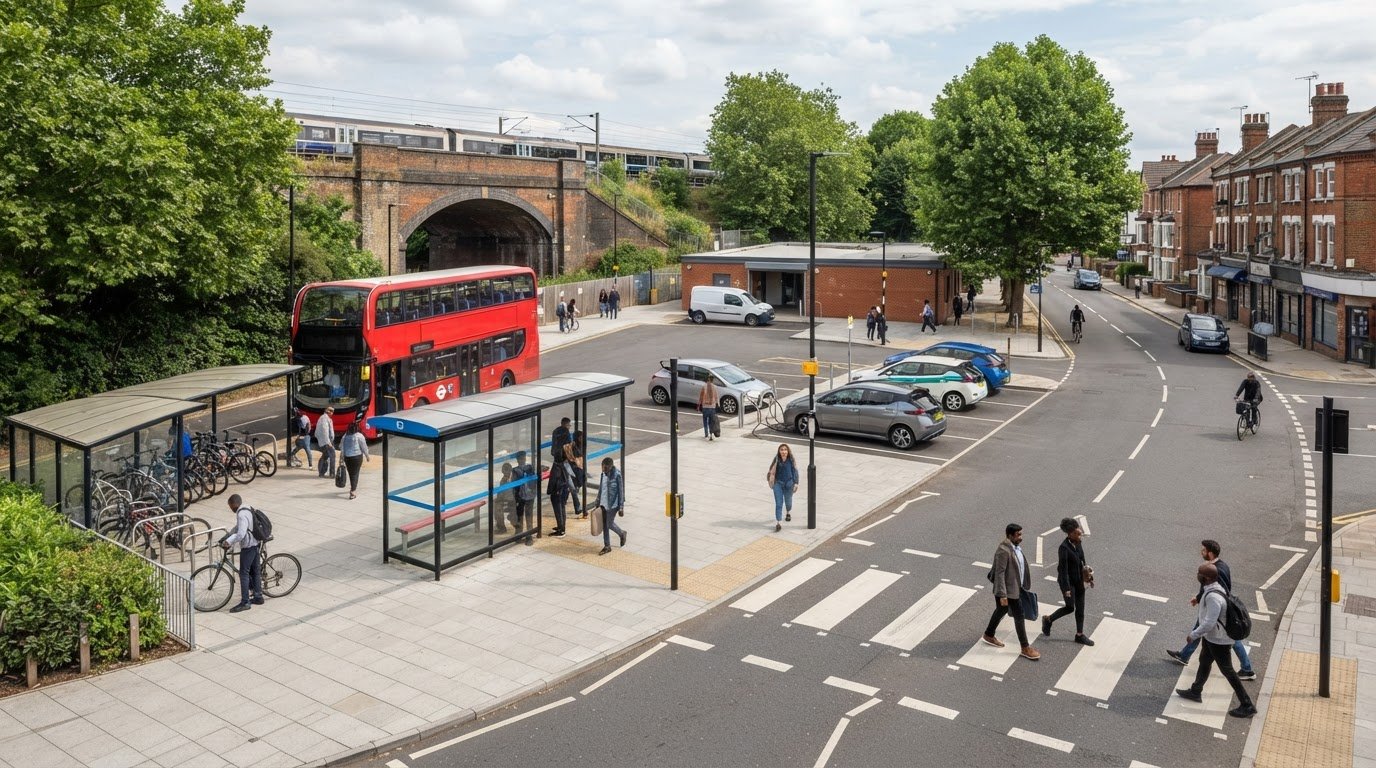
    Map connections between the site and nearby public transport stops, walking and cycling routes, and local streets. Review how people reach the hub, move between its facilities and continue their journey. Consider access and movement beyond the red line where the proposal could affect wider routes, rather than treating the boundary as the limit of its transport influence.

    A mobility hub assessment evaluates how the development’s connected services shape journeys to, through and beyond the site, and what those journeys mean for the surrounding transport network. Tailor the report to the proposal and planning context. There’s no single template that can replace proportionate consideration of local conditions and the expectations of the relevant planning and highway authorities.

    How should the assessment examine mobility hub travel demand and impacts?

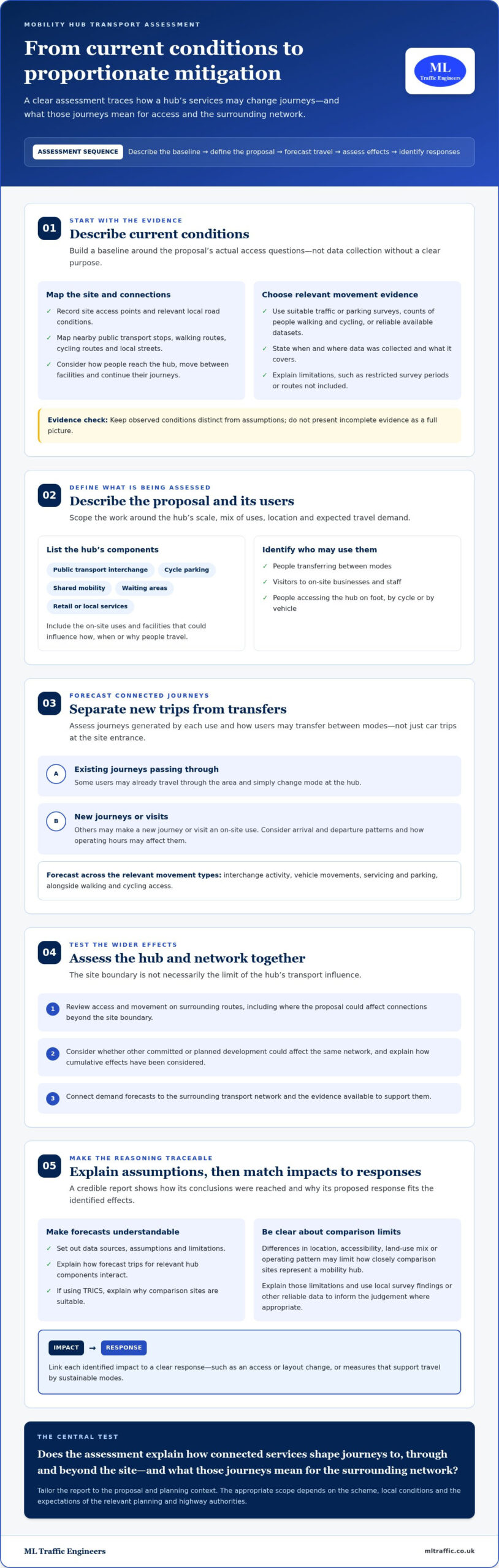
    A robust assessment follows a clear sequence: describe current conditions, define the proposal, estimate how it may change travel, assess effects on access and the surrounding network, then identify proportionate mitigation. This makes the reasoning traceable for decision-makers. A transport assessment for mobility hub should consider the journeys generated by each use as well as transfers between modes, rather than treating the hub as a single source of vehicle trips.

    The UK Government guidance on Transport Assessments provides a national reference point for assessment scope. The report should also respond to the scheme and its planning context, setting out data sources, assumptions and limitations so readers can follow how conclusions were reached.

    What baseline information helps describe the site?

    Record site access points and relevant local road conditions, alongside walking and cycling connections and nearby public transport services. Establish existing movement patterns using suitable traffic or parking surveys, counts of people walking and cycling, or reliable available datasets. Choose evidence to answer specific questions raised by the proposal rather than collecting data without a clear purpose.

    State when and where data was collected, what it covers and any factors that could affect its representativeness. For example, explain if a count covers only particular periods or excludes a route that may influence access. Documenting limitations helps distinguish observed conditions from assumptions and avoids presenting incomplete evidence as a full picture.

    How can the report assess forecast trips and network effects?

    Estimate demand for each relevant hub component, then explain how those trips interact. A traveller transferring from a bus to a shared bicycle is different from a new visitor arriving by car to use an on-site facility. Consider arrival and departure patterns, interchange activity, vehicle movements, servicing and parking, as well as walking and cycling access. Where other committed or planned development could affect the same network, explain how cumulative effects have been considered.

    Forecasts depend on a proposal’s uses, location and the evidence available to support the assumptions. If TRICS is used, select comparison sites with relevant characteristics and explain why they are suitable. Differences in location, accessibility, land-use mix or operating pattern may limit how closely those sites represent a mobility hub. Set out those limitations and use local survey findings or other reliable data to inform the judgement where appropriate.

    Finally, connect each identified impact to a clear response, such as an access or layout change, or measures that support travel by sustainable modes. For project-specific assessment and supporting transport evidence, see ML Traffic Engineers.

    When does a mobility hub need a Transport Assessment rather than a shorter report?

    There’s no universal trip threshold that determines the right report for every mobility hub. The local planning authority considers the proposal, its likely transport effects and relevant planning guidance. A transport assessment for mobility hub proposals may need to be more detailed where several uses and travel modes interact, but the appropriate scope depends on the site and the evidence needed to explain its effects.

    A Transport Assessment generally provides a more comprehensive examination of transport impacts, forecast demand and mitigation. A Transport Statement is a shorter, proportionate report for proposals where a more limited level of analysis is appropriate. For a hub, the distinction isn’t simply the number of facilities. A compact scheme could still raise complex access or interchange questions, while a larger proposal in a well-connected location may present a different evidence task. The report type and scope should reflect the planning context, not a generic template.

    Which project characteristics may widen the assessment scope?

    Consider the scale and mix of uses, anticipated demand, access arrangements and sensitivity of the surrounding network. A hub bringing together public transport, cycle facilities, shared vehicles and commercial uses can generate linked journeys that need to be explained as one movement pattern. Accessibility belongs in that picture too. Examine how people can reach the site and transfer between facilities, including the continuity of walking routes and the practical relationship between entrances and transport stops.

    Authority feedback and local site conditions may also affect what evidence is proportionate. Constrained access, nearby junctions or a proposal connecting with several routes could prompt more detailed analysis than a straightforward site with limited effects.

    How do local planning and highway authority expectations fit?

    The local planning authority determines the planning information it expects to assess the application. The relevant highway authority may provide technical advice on effects involving roads or transport infrastructure within its remit. Understanding both roles can help shape a clear scope. Current national guidance and local validation requirements should inform the approach for the specific application.

    Requirements can differ between Greater London, Manchester, Birmingham, the West Midlands, Liverpool, Surrey, East Sussex, West Sussex, Hampshire, Berkshire and Buckinghamshire because local planning policy, transport networks and authority guidance vary. Don’t assume that an approach accepted in one location will suit another. For wider London planning context, see this Transport Assessment London guide.

    For a mobility hub, the practical choice is the report that gives decision-makers enough reliable evidence to understand the scheme’s connected travel effects, without adding analysis that doesn’t help answer a planning question. Shape the scope around the relevant authority guidance and feedback before finalising the assessment approach.
    Transport Assessments for Mobility Hubs: A UK Planning Guide

    What evidence and design decisions make a mobility hub assessment more useful?

    A useful assessment starts with coordinated project information, then tests how the proposed layout works for people and vehicles. Transport questions should inform design from the outset: access, interchange, cycle provision, parking and servicing all compete for space and can affect one another. Reviewing them together helps identify conflicts before the report is finalised.

    Which project information should the assessment team review?

    Prepare a clear evidence trail from the scheme brief to the assessment conclusions. A practical sequence is:

    • 1. Define the proposal. Set out the location, intended uses, facilities, operating arrangements and phasing.
    • 2. Share the plans. Provide location plans, site layouts and access drawings that show entrances, cycle facilities, parking, servicing areas and connections to nearby routes.
    • 3. Explain travel assumptions. Record available estimates of users, journey types and arrival patterns, noting their source and any limitations.
    • 4. Review the evidence. Compare the project information with relevant surveys and available transport data to identify gaps that could affect the analysis.
    • 5. Resolve uncertainties. Flag missing inputs early. If assumptions are needed, state them clearly and explain how they influence the assessment’s findings.

    This sequence keeps the report grounded in the actual design rather than a generic description of a mobility hub. For related preparation considerations in London, see the Transport Assessment London guide.

    How can inclusive access and interchange be assessed?

    Trace a complete journey from the surrounding network to the site and between its facilities. Check how people reach entrances from public transport stops, walking and cycling routes, and onward destinations. Consider whether routes are continuous and legible, where crossing points sit, and whether the layout makes transfers straightforward. Include different users’ access needs in this review, rather than treating accessibility as a separate item after the site plan is settled.

    Inclusive access is measured by the quality of the complete journey, not just the facilities provided at the hub. A cycle parking area, for example, is less useful if its approach conflicts with servicing movements or leaves a gap in the onward route.

    Mitigation should respond directly to the impacts identified in the assessment. It might involve refining access arrangements, improving route connections or adjusting the position of facilities. Explain how each measure addresses a specific issue and ensure it is practical within the proposed design and phasing. To develop a clear, project-specific evidence base, discuss your mobility hub Transport Assessment.

    How can ML Traffic Engineers support a mobility hub planning submission?

    A clear planning submission needs more than a description of the proposed facilities. It should connect the scheme’s plans and intended uses with relevant transport evidence, explain likely impacts, and show how those impacts have informed the design or mitigation. ML Traffic Engineers prepares Transport Assessments and supporting technical evidence for planning applications, tailored to the proposal and its context.

    What can a tailored Transport Assessment bring together?

    The work follows a practical sequence: understand the proposal, define the evidence needed, analyse the transport effects, then present findings and responses in a structured report. For a mobility hub, that means assessing the relationship between its facilities and expected journeys, not treating each component in isolation.

    Traffic surveys can help describe movement on relevant routes, while parking surveys can provide evidence about existing parking conditions. Where vehicle access or manoeuvrability is a project question, Swept Path Analysis can test vehicle movements against the proposed layout. The appropriate evidence depends on the site and the issues the assessment needs to address.

    Bringing these inputs together helps decision-makers follow how the project information and evidence support the assessment’s conclusions. For wider London planning context, see the Transport Assessment London guide.

    What are the next steps for a mobility hub proposal?

    Organise the current project information before preparing the assessment brief. Useful starting materials include:

    • Location and layout plans, including access points and proposed transport facilities.
    • A summary of proposed uses, operating arrangements and expected project stages.
    • Available information about travel demand, parking, servicing and vehicle access.
    • Any existing survey data or relevant discussions with the planning or highway authority.

    These inputs help define the assessment scope and identify evidence gaps early. If plans are still developing, share the current version and clearly identify what remains subject to change. The assessment can then reflect the proposal accurately and explain any assumptions used.

    ML Traffic Engineers prepares project-specific Transport Assessments for mobility hubs, supported by traffic or parking survey evidence and Swept Path Analysis where relevant. Discuss your mobility hub transport assessment and take the next step towards a clear, evidence-led planning submission.

    Prepare a Clear Case for Your Mobility Hub

    A credible mobility hub submission explains how the proposal’s uses and transport connections shape journeys, not just what facilities sit on the site. A proportionate transport assessment for mobility hub should draw on suitable evidence, make its assumptions clear and connect forecast impacts to practical mitigation.

    Start with the project plans, access arrangements and available travel information, then shape the assessment around the site and relevant authority expectations. Consider how public transport, walking, cycling, servicing and parking work together, including the complete journey for different users. Clear, project-specific analysis gives decision-makers a stronger basis for understanding the proposal.

    ML Traffic Engineers prepares Transport Assessments and Transport Statements for planning applications, supported where relevant by traffic surveys, parking surveys and Swept Path Analysis. These inputs help bring the proposal, evidence and transport conclusions together in a focused report.

    Ready to progress your planning submission? Discuss your mobility hub transport assessment with ML Traffic Engineers and take the next step with confidence.

    Frequently Asked Questions

    What is a transport assessment for a mobility hub?

    A transport assessment for a mobility hub is a project-specific report explaining how the proposal may affect travel and how those effects can be addressed. It considers the hub’s uses, transport connections, access arrangements and expected journeys, alongside relevant conditions on nearby routes. The report brings evidence and analysis together so planning decision-makers can understand the proposal’s likely impacts and the reasoning behind proposed mitigation.

    When does a mobility hub need a Transport Assessment?

    The local planning authority determines the transport information expected for an application, based on the proposal, its likely impacts and relevant guidance. There is no single threshold that applies to every mobility hub. Local context matters across Greater London, Manchester, Birmingham, the West Midlands, Liverpool, Surrey, East Sussex, West Sussex, Hampshire, Berkshire and Buckinghamshire. Establish the proportionate scope for the specific site using applicable authority guidance.

    What should a mobility hub transport assessment include?

    It should set out the proposal and relevant baseline conditions, then assess expected travel demand, access and effects on the surrounding network. Depending on the scheme, evidence may cover walking, cycling, public transport, vehicle movements, interchange, servicing and parking. The report should explain its data sources, assumptions and limitations, then connect identified impacts to practical mitigation. Its scope should reflect the hub’s uses, location and likely transport effects.

    How are trips to and from a mobility hub assessed?

    Assessment starts by identifying the journeys associated with each proposed use and facility. It distinguishes new trips from existing journeys that transfer between modes, then considers arrival and departure patterns, vehicle movements and effects on nearby routes. Surveys and suitable available datasets can inform forecasts. Where TRICS is used, the report should explain why comparison sites are relevant and note limitations that affect how well they represent the proposed hub.

    Does a mobility hub assessment need to consider accessibility?

    Yes. Accessibility should inform the assessment of the complete journey, from surrounding streets and public transport stops to site entrances, facilities and onward routes. Consider route continuity, crossing points, wayfinding and how people with different access needs can move between modes. This helps identify barriers that a review of facilities inside the site alone could miss, and supports a more complete understanding of how the hub is likely to function.

    Who reviews a transport assessment for a mobility hub?

    The local planning authority considers the application’s transport evidence as part of its planning decision. The relevant highway authority may provide technical input on transport effects and roads within its remit. The precise review arrangements depend on the site and application context. A clear report that explains its evidence, assumptions and proposed responses can help decision-makers and technical consultees understand how the assessment reaches its conclusions.

    How early should transport assessment work start for a mobility hub?

    Start during early project planning, while the site layout and access arrangements can still respond to transport findings. Share current plans, proposed uses, access details and known project stages so the assessment scope and evidence needs can be identified. Early work can also highlight data gaps and help align the design with likely user journeys. If plans change, update the assessment inputs so its conclusions remain relevant to the proposal.

    Michael Lee

    Article by

    Michael Lee

    Transport planner with over 35 years' experience.

    Disclaimer

    The content on mltraffic.co.uk, including all technical articles, guides, and resources, is provided for general informational and educational purposes only. It is not intended to constitute professional advice in traffic engineering, transportation planning, development approvals, or any other technical or legal field.
    While ML Traffic Engineers makes every reasonable effort to ensure the accuracy, completeness, and timeliness of the information published, we do not provide any warranties or representations (express or implied) regarding its reliability, suitability, or availability for any particular purpose. Any reliance you place on the content is strictly at your own risk.
    In no event shall ML Traffic Engineers, its directors, employees, authors, or affiliates be liable for any direct, indirect, incidental, special, consequential, or punitive damages (including, without limitation, loss of profits, data, or business opportunities) arising out of or in connection with the use of, or inability to use, any information provided on this website.
    The articles and guides on this site are not a substitute for engaging a qualified, professional traffic engineer to assess your specific project requirements. For tailored advice, compliance assessments, or traffic engineering services, please contact a competent professional.
    This disclaimer may be updated from time to time without notice. By accessing or using this website, you agree to be bound by the most current version of this disclaimer.
  • Transport Assessment: Town Centre Regeneration 2026 Guide

    Transport Assessment: Town Centre Regeneration 2026 Guide

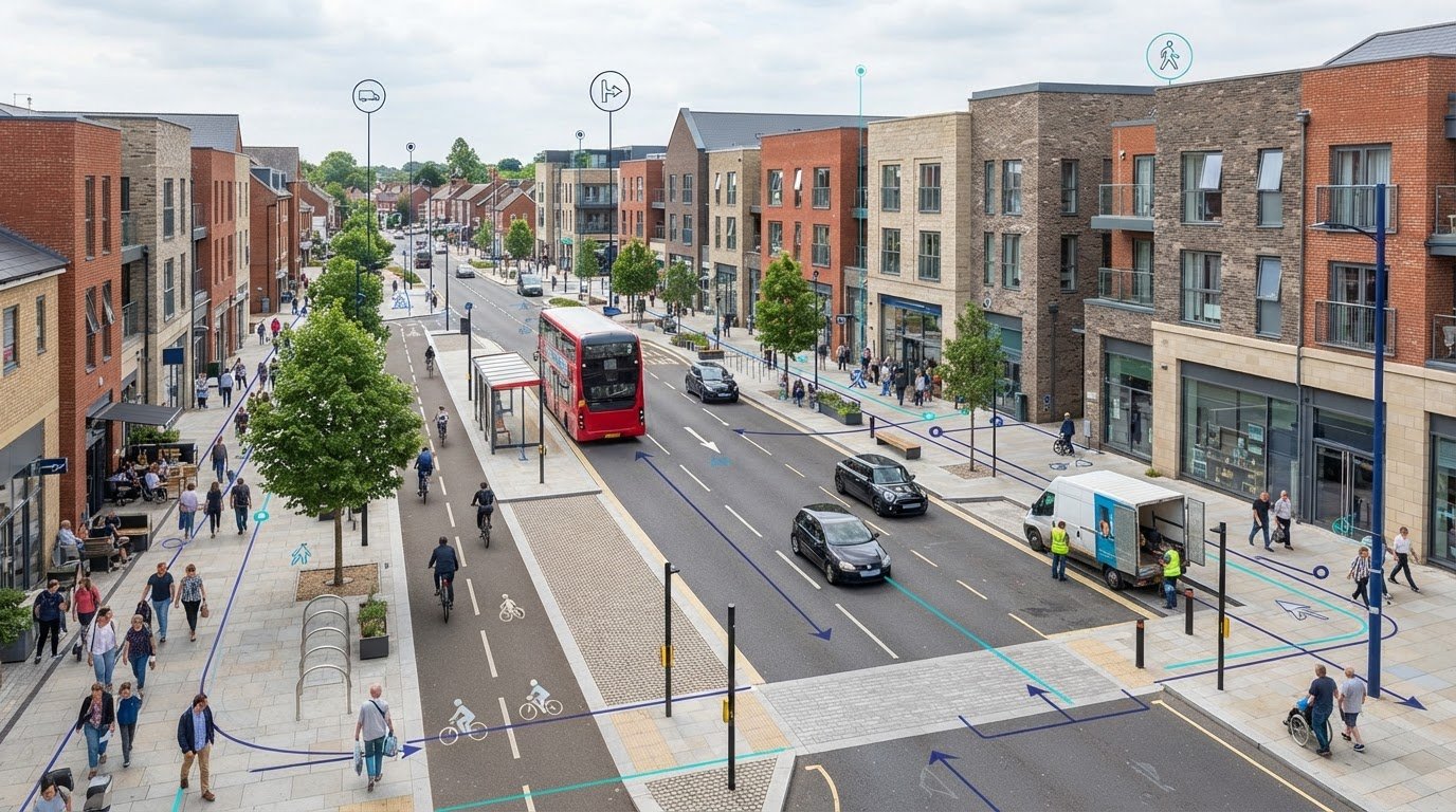
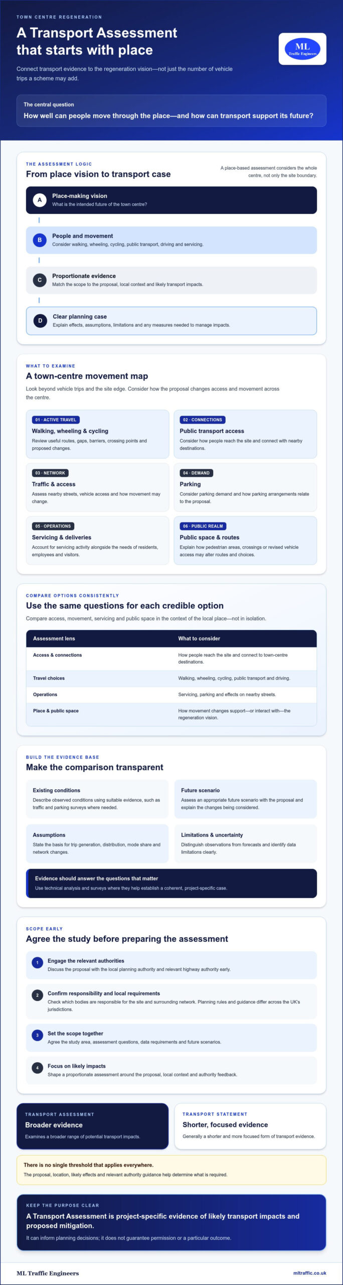
    What if the success of town centre regeneration depended less on how many vehicle trips a scheme adds and more on how well people can move through the place? A transport assessment for town centre regeneration should connect transport evidence to the vision for the area, not simply count development trips. That means considering how people will walk, wheel, cycle and use public transport, alongside servicing, parking and traffic effects.

    It’s understandable to be unsure which impacts need detailed assessment. Regeneration schemes often combine new uses, changing travel patterns and public-realm ambitions, while local planning and highway authority requirements can vary. Agreeing a proportionate scope early helps focus evidence on the issues that matter and reduces the risk of gaps holding up a planning application.

    This guide explains what a regeneration-focused Transport Assessment should examine, how to choose suitable evidence and how to relate the analysis to the place-making vision. It also covers traffic and parking surveys, access and movement, servicing, and cumulative effects, so you can build a clearer transport case for your proposal.

    Key Takeaways

    • A transport assessment for town centre regeneration should show how movement supports the place-making vision, not just quantify vehicle trips.
    • Scope the assessment around the proposal, local context and likely transport impacts. Distinguish observed conditions from assumptions and forecasts.
    • Compare credible regeneration options by considering access, walking, wheeling, cycling, public transport, servicing and public space.
    • Agree the study area, assessment questions, data requirements and future scenarios with the relevant authorities early in the planning process.
    • Traffic surveys, parking surveys and technical analysis can help build a coherent evidence base for a planning submission where needed.

    What a Transport Assessment means for town centre regeneration

    A transport assessment for town centre regeneration explains how a proposal could affect movement and access, and what measures may be needed to manage those effects. It relates transport evidence to the intended future of the place, rather than treating the scheme as a standalone source of vehicle trips. This place-based perspective is consistent with regenerative urban development, where change is considered in relation to the wider urban environment.

    In brief: A Transport Assessment is project-specific evidence of likely transport impacts and proposed mitigation. It can inform planning decisions, but it does not guarantee permission or a particular outcome.

    The appropriate document depends on the development and its context. A Transport Statement is generally a shorter, more focused form of transport evidence, while a Transport Assessment examines a broader range of potential impacts. There is no single threshold that applies everywhere. The proposal, location, likely effects and relevant authority guidance all help determine what is required.

    To see how town centre regeneration can shape a place, watch Town Centre Regeneration from Owen Thompson MP for Midlothian:

    How regeneration differs from a single-use development

    A town centre scheme can combine homes, shops, workplaces and community uses. Their travel patterns may vary by time of day: residents travel for work or everyday needs, employees arrive for shifts, visitors come to shop or attend activities, and deliveries serve businesses. The assessment should consider these groups alongside people already using the centre, not only trips associated with new buildings.

    Public-realm proposals also matter. A new pedestrian area, changed crossing point or revised vehicle access may alter routes and choices for people walking, wheeling, cycling, driving or using public transport. Explain how these changes interact with existing movement and the regeneration vision.

    Who helps shape the assessment scope?

    Engage the local planning authority and relevant highway authority early. The scope should reflect the proposal, its location, likely transport effects and feedback from those authorities. Confirm which bodies are responsible for the site and surrounding network before agreeing evidence requirements.

    Planning policy and responsibilities differ across the UK, so check the rules and guidance for the project’s jurisdiction rather than assuming requirements are identical in England, Scotland, Wales and Northern Ireland. Early scoping can establish the study area, key questions and suitable evidence before the assessment is prepared.

    What transport impacts should a regeneration assessment examine?

    A regeneration assessment should examine how the proposal changes access and movement across the town centre, not just at the site boundary. Relevant effects may include walking and cycling connections, public transport access, traffic on nearby streets, parking demand, servicing activity and changes to public space. The official government guidance provides a starting point, but the scope should reflect the development and local authority requirements.

    Build the analysis around a clear comparison: describe observed existing conditions, then assess an appropriate future scenario with the proposal. State the assumptions behind trip generation, distribution, mode share and network changes. Identify data limitations so decision-makers can see what the analysis establishes and where uncertainty remains.

    Access, walking, cycling, and public transport

    Review how people reach the site and connect with nearby streets, shops, services and other town centre destinations. For walking and cycling, map useful routes, gaps, barriers, crossing points and proposed changes. Consider whether public-realm proposals redirect movement or change access for existing users. Assess public transport access and, where relevant, capacity using current, project-specific evidence. Set study area boundaries to capture the routes and connections likely to be affected, and discuss them with the relevant authorities.

    Traffic, parking, servicing, and inclusive access

    Explain how trip-generation and distribution assumptions were selected, and use methods suited to the proposal. Consider how new trips interact with existing traffic and other committed or proposed development where cumulative effects may be relevant. Compare the future scenario with the baseline, distinguishing observed data from forecasts and assumptions.

    Parking analysis should relate to the proposed uses and local context. Examine how servicing activity could affect access, street operation and public space. Check movement needs for different users, including people who walk, cycle, use public transport, drive, wheel or require step-free access. Local standards and authority expectations can vary, so confirm applicable requirements rather than assuming one approach fits every town centre.

    In practice, link each identified impact to its evidence, the people or routes affected, and proportionate mitigation. This makes the assessment traceable: readers can understand what may change, why the conclusion is reasonable and how proposed measures respond. For a transport assessment for town centre regeneration, agree the study area, assessment questions and relevant development scenarios with the local planning and highway authorities early. Specialist Transport Assessment support, informed by traffic or parking surveys where needed, can help bring that evidence together.

    How to assess regeneration options without overlooking local context

    Comparing credible options shows how design choices may affect movement through a town centre. Start with a clearly described baseline, then distinguish it from assumptions, forecast scenarios and proposed interventions. For each option, explain what changes and why. A transport assessment for town centre regeneration should make these distinctions clear so readers can trace the evidence behind each conclusion.

    Assessment area Option A: retain current access Option B: revise access and public space
    Access and movement How existing routes connect the site to town centre destinations Which routes or connections change, and for whom
    Servicing How existing delivery access operates How revised arrangements affect servicing and nearby streets
    Public space How current vehicle and pedestrian space is used What space is reallocated and how movement responds

    Adapt the comparison to the actual proposals. The table exposes trade-offs; it does not imply that an option is preferred before its effects are assessed. A place-based approach also reflects the case for long-term transport investment, connecting transport decisions with wider town centre objectives.

    Building a reliable baseline and choosing evidence

    Gather evidence that answers the agreed assessment questions. Depending on the location and proposal, this may include traffic and parking data, walking and cycling conditions, and public transport information. Use surveys when available records do not provide a suitable picture. Record survey dates, locations, coverage and limitations, and explain any adjustments made for analysis. This allows decision-makers to judge how well the evidence represents the conditions being assessed.

    Comparing options and cumulative effects

    Set out the baseline and future scenarios separately. Identify nearby committed proposals using information agreed with the relevant authorities, then explain which are included in the cumulative assessment and how their effects are represented. If development is phased, uses may change or information is incomplete, state what has been assumed and how this could affect forecasts.

    Forecasts and model outputs are estimates, not certainty. Explain the method, key inputs and limitations, then interpret what the results mean for access, movement, servicing and public space. For London projects, the Transport Assessment London guide offers a location-specific companion; it is not a substitute for checking requirements elsewhere in the UK.

    Where specialist evidence would help bring the options and supporting data together, review Transport Assessment support.

    Transport Assessment: Town Centre Regeneration 2026 Guide

    How to scope and prepare a town centre Transport Assessment

    A clear scope gives the assessment a practical purpose: explain the proposal, identify likely transport effects and provide evidence for proportionate recommendations. For a transport assessment for town centre regeneration, agree the questions and study area before commissioning surveys or technical analysis. This keeps the work focused on the proposal and local context.

    A practical sequence from proposal review to assessment

    1. Describe the proposal. Set out the uses, scale, phasing, access arrangements and regeneration objectives. Note what is fixed and what may change.
    2. Identify assessment questions. Consider which routes, users and transport operations could be affected, including walking, cycling, public transport, traffic, parking and servicing.
    3. Agree the scope with authorities. Consult the local planning authority and relevant highway authority on the study area, evidence requirements, baseline and future scenarios. Confirm which nearby proposals should be considered.
    4. Collect suitable evidence. Use existing information where it answers the agreed questions. Where it does not, identify whether traffic surveys, parking surveys or other relevant data are needed.
    5. Analyse and report. Explain methods, assumptions, survey dates and limitations. Present findings against the agreed scenarios, then connect identified effects to appropriate mitigation.

    Let the scope determine the evidence, rather than collecting data first and deciding later how to use it. For example, a parking survey may help establish existing demand if parking effects are a key assessment question. Traffic data may be needed to understand how a proposed access interacts with nearby streets, while footfall analytics from providers such as Smart Urban Sensing Ltd can clarify pedestrian movement patterns. Choose methods to address identified information gaps, not as a default checklist.

    Turning findings into proportionate mitigation

    Recommendations should respond directly to evidenced impacts. Explain what measure is proposed, which effect it addresses and who would be responsible for taking it forward. Keep the assessment’s recommendations distinct from any separately commissioned design work or audit services. The assessment can identify a transport issue and intended response without implying that every related service forms part of the assessment commission.

    A Travel Plan may complement the assessment where it suits the proposal, helping set out measures to support travel choices associated with the development. Its role should be consistent with the assessment’s assumptions and conclusions.

    ML Traffic Engineers UK prepares Transport Assessments and related transport evidence for development proposals. Developers can review project types and planning support to consider relevant experience. To discuss assessment evidence for a regeneration proposal, contact ML Traffic Engineers UK.

    How specialist Transport Assessment support can strengthen the planning submission

    A well-structured assessment gives decision-makers a clear line of sight from the regeneration proposal to its likely transport effects and proposed mitigation. It brings together development details, local context, supporting evidence and analysis, while making assumptions and limitations visible. For a transport assessment for town centre regeneration, this joined-up account helps explain how transport considerations relate to the scheme’s objectives. It supports planning decisions, but cannot guarantee permission or a particular outcome.

    Specialist input can help establish what evidence a project needs. Traffic surveys may inform analysis of network conditions, while parking surveys can help describe existing demand. Technical analysis then relates suitable evidence to the proposal and agreed assessment questions. Each method should have a clear purpose, rather than being included by default.

    What to look for when appointing assessment support

    Check whether the consultant has experience preparing transport documentation for planning proposals relevant to your development type. Ask how they will agree the assessment scope with you and the relevant authorities, identify data requirements, and document assumptions in the report. Confirm which services suit the brief, such as a Transport Assessment, traffic or parking surveys, or Swept Path Analysis where vehicle movement needs to be examined.

    Clarity on responsibilities also matters. Establish what the assessment will cover, what evidence is required from other project contributors, and which recommendations may need separate design or delivery work. This keeps the report focused and makes its conclusions easier to follow.

    Prepare for an initial project discussion

    Gather information that will help define the scope and identify gaps. A useful starting pack includes:

    • A site location plan and current proposal details, including uses and phasing where known.
    • Available information on site access, parking, servicing and connections to nearby streets.
    • Transport data already collected, with dates and coverage if known.
    • Planning milestones, authority feedback and any known transport constraints.
    • Unresolved questions, such as which scenarios or nearby proposals may need consideration.

    This preparation helps focus early discussions on the project’s actual requirements. It also gives the assessment team a basis for identifying proportionate survey and analysis needs, rather than making assumptions before the proposal and local context are understood.

    ML Traffic Engineers prepares Transport Assessments and related transport evidence for development proposals. Its transport services include traffic and parking surveys and Swept Path Analysis where appropriate to the project. Details of these services can help you identify support relevant to the brief.

    Set your regeneration proposal up for a clear transport case

    A strong transport assessment for town centre regeneration connects the development vision with the way people and goods move through the area. Its scope should reflect local conditions, the proposal’s likely effects and relevant authority feedback. Clear assumptions, proportionate evidence and mitigation linked to identified impacts make the planning submission easier to assess.

    Start by agreeing the study area, assessment questions and relevant scenarios. Then use suitable evidence, including traffic or parking surveys where needed, to explain existing conditions and potential change. A coherent report supports informed planning decisions, but it cannot guarantee planning permission.

    ML Traffic Engineers is a UK consultancy providing Transport Assessments for planning submissions, with traffic and parking survey capabilities to inform project evidence. Its local focus includes Greater London, Manchester, Birmingham, the West Midlands, Liverpool, Surrey, East Sussex, West Sussex, Hampshire, Berkshire and Buckinghamshire. If you’re preparing a regeneration proposal, discuss your town centre regeneration assessment to explore the scope and evidence it may require.

    Frequently Asked Questions

    What is a Transport Assessment for town centre regeneration?

    A Transport Assessment is a project-specific report that examines how a development may affect transport and sets out potential mitigation. A transport assessment for town centre regeneration considers the scheme alongside existing town centre movement, planned changes and local conditions. It may draw on traffic or parking surveys and technical analysis where needed. The report supports planning decisions by presenting evidence, but it doesn’t guarantee permission.

    When is a Transport Assessment required for a regeneration project?

    The need for a Transport Assessment depends on the proposal, its location, likely transport effects and local authority requirements. There isn’t one threshold that applies to every regeneration project across the UK. Discuss the scope early with the local planning authority and relevant highway authority. They can help determine whether a Transport Assessment or a more focused Transport Statement is appropriate and what evidence the submission should include.

    What should a town centre Transport Assessment include?

    A town centre Transport Assessment should address the transport questions raised by the proposal. Depending on its scope, this can include site access, walking and cycling connections, public transport, traffic, parking, servicing and public-realm changes. It should describe existing conditions, assess suitable future scenarios, explain assumptions and limitations, and connect identified impacts to proportionate mitigation. Traffic surveys, parking surveys or other technical analysis may inform the report where the agreed scope requires them.

    How do you assess transport impacts for a mixed-use regeneration scheme?

    Assess each proposed use and consider how travel patterns may vary across the day. Homes, shops, workplaces and community uses can attract different residents, employees, visitors and deliveries. Compare the existing baseline with appropriate future scenarios, explaining assumptions about trips and how nearby development is treated. Consider access, movement choices, network operation, parking and servicing together so the analysis reflects how the mixed-use scheme may function as part of the town centre.

    Should a Transport Assessment consider walking and cycling in a town centre?

    Yes. The assessment should consider how the proposal connects with existing walking and cycling routes and whether access or movement may change. Examine route continuity, barriers, crossing points and links to town centre destinations. Where the scheme changes public space or street access, explain how those changes could affect people walking, cycling or wheeling. The scope should reflect local conditions and authority feedback, rather than assuming the same analysis applies to every site.

    How early should a transport consultant be involved in town centre regeneration?

    Involve a transport consultant while the proposal and access arrangements are still being developed. Early input can help identify likely transport questions, agree a study area with relevant authorities and establish whether traffic or parking surveys are needed. This applies whether the site is in Greater London, Manchester, Birmingham, the West Midlands, Liverpool, Surrey, East Sussex, West Sussex, Hampshire, Berkshire or Buckinghamshire, where project requirements must be checked locally.

    Can a Transport Assessment help support planning permission?

    A Transport Assessment can support a planning application by providing evidence about likely transport effects and proposed mitigation. A clear report helps decision-makers understand the proposal, local context, analysis and how identified impacts may be addressed. It doesn’t secure planning permission or guarantee a particular decision. The assessment should follow current, relevant planning policy and authority guidance for the project’s location, with its methods and limitations explained clearly.

    Michael Lee

    Article by

    Michael Lee

    Transport planner with over 35 years' experience.

    Disclaimer

    The content on mltraffic.co.uk, including all technical articles, guides, and resources, is provided for general informational and educational purposes only. It is not intended to constitute professional advice in traffic engineering, transportation planning, development approvals, or any other technical or legal field.
    While ML Traffic Engineers makes every reasonable effort to ensure the accuracy, completeness, and timeliness of the information published, we do not provide any warranties or representations (express or implied) regarding its reliability, suitability, or availability for any particular purpose. Any reliance you place on the content is strictly at your own risk.
    In no event shall ML Traffic Engineers, its directors, employees, authors, or affiliates be liable for any direct, indirect, incidental, special, consequential, or punitive damages (including, without limitation, loss of profits, data, or business opportunities) arising out of or in connection with the use of, or inability to use, any information provided on this website.
    The articles and guides on this site are not a substitute for engaging a qualified, professional traffic engineer to assess your specific project requirements. For tailored advice, compliance assessments, or traffic engineering services, please contact a competent professional.
    This disclaimer may be updated from time to time without notice. By accessing or using this website, you agree to be bound by the most current version of this disclaimer.
  • 2026 Transport Assessment: Waltham Forest Events Venue

    2026 Transport Assessment: Waltham Forest Events Venue

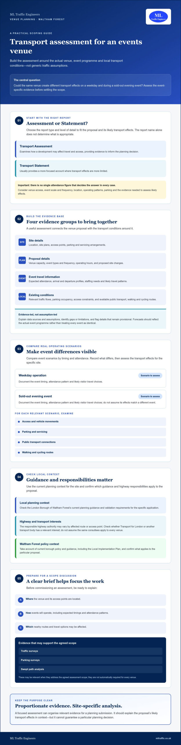
    Could the same venue create very different transport impacts on a weekday and during a sold-out evening event? A transport assessment for events venue in Waltham Forest should start with event-specific evidence, not generic traffic assumptions. Attendance, event schedules and visitor travel choices can all affect access, parking, servicing and public transport.

    It’s understandable to be unsure what the planning authority will expect, especially when different event formats can produce different travel patterns. The right scope depends on the venue, its location and its likely transport effects. A proportionate assessment can organise relevant evidence for a planning submission, but it cannot guarantee a particular planning decision.

    This guide explains what a venue-focused Transport Assessment should examine, when a Transport Statement may be more appropriate, and what site, event and travel information can help. It also covers surveys and other supporting evidence, the importance of current Waltham Forest guidance, and what to consider when appointing a transport consultant. Use it to prepare for a scope discussion and planning application.

    Key Takeaways

    • Match the report type and level of detail to the proposal and its likely transport effects, then check the scope against current authority guidance.
    • A transport assessment for events venue in Waltham Forest should use evidence about the site, event programme and existing travel conditions, not generic assumptions.
    • Compare event scenarios by timing and attendance. Assess access, parking, servicing and travel by public transport, walking and cycling in the context of the specific site.
    • Before commissioning work, clarify the proposal, agree the assessment scope and ask how relevant evidence will be gathered and analysed.
    • Traffic surveys, parking surveys and swept path analysis may support a venue planning application when relevant to the agreed scope.

    When does an events venue in Waltham Forest need a transport assessment?

    A venue proposal doesn’t automatically require the same transport report as every other venue. The appropriate scope depends on what’s proposed and the likely effects on the surrounding transport network. A transport assessment for events venue in Waltham Forest should be scoped to the actual site and operating plans, not selected using an assumed attendance or trip threshold.

    A Transport Assessment examines how a development may affect travel and access, providing evidence to inform the planning decision. A Transport Statement usually provides a more focused account where transport effects are more limited. Neither report type should be chosen by name alone. Consider the venue’s access, event scale, location and operating pattern, along with current authority guidance and the information needed to assess likely effects.

    Transport assessment forms part of the wider transportation planning process, which considers how people and goods move through a network. For a venue, that means looking beyond vehicle movements to how the proposal connects with different travel options and the local context.

    Transport Assessment or Transport Statement for a venue proposal?

    An early scoping discussion can help establish the proportionate level of assessment before evidence is commissioned. Relevant factors may include venue capacity, event types and frequency, arrival and departure patterns, access design, parking provision and proximity to public transport. No single attendance figure determines the answer in every case. For broader background on assessment content, see this London Transport Assessment guide.

    Which local authorities and transport bodies may be relevant?

    The London Borough of Waltham Forest is the local planning context, so check its current planning guidance and validation requirements for the specific application. Highway consultation may involve the authority responsible for roads affected by the proposal, which can vary by route or access point. Check whether Transport for London or another transport body has a relevant interest in the site or network instead of assuming the same consultees apply to every venue.

    Before settling the scope, prepare a clear description of the proposal and identify:

    • Where the venue and its access points are located.
    • How events will operate, including expected timings and attendance patterns.
    • Which nearby routes and transport options may be affected.

    Confirm relevant guidance and highway responsibilities early. This gives the assessment a defined purpose and helps avoid collecting evidence that doesn’t address the planning questions for the site.

    What evidence should a Waltham Forest venue transport assessment use?

    A useful assessment starts with a clear picture of the venue proposal and the transport conditions around it. Bring together:

    • Site details: location, site plans, access points, parking and servicing arrangements.
    • Proposal details: capacity, event types and frequency, operating hours, and any proposed changes to the site.
    • Event travel information: expected attendance, arrival and departure profiles, staffing needs and likely travel patterns.
    • Existing conditions: relevant traffic flows, parking occupancy, access constraints, and available public transport, walking and cycling routes.

    A Transport Assessment is evidence-led analysis of how a proposed development may affect the transport network and how those effects relate to the site and its users. For an events venue, forecasts should reflect the actual programme rather than assume every event generates the same travel demand. The report should identify its data sources and assumptions, explain gaps or limitations in the available information, and flag details that remain provisional.

    Local context matters. Take account of current borough policy and guidance, including Waltham Forest’s Local Implementation Plan, while checking which requirements apply to the specific planning proposal.

    What venue and event information should the client prepare?

    Provide the latest available site plans and a schedule covering capacity, event types, frequency and operating hours. Add expected arrival and departure patterns, staffing requirements, parking provision and your best estimate of how visitors may travel. Mark unconfirmed figures and plans as provisional. This makes assumptions visible and helps the assessment team consider how changes to the proposal could affect the analysis.

    When are traffic or parking surveys useful?

    Surveys can help establish existing conditions when published information or initial evidence doesn’t answer the planning questions. Depending on the site, proposal and authority feedback, this could include traffic flows, parking occupancy or observations of access conditions. The assessment should explain why each survey is relevant and how its results inform the analysis. Determine the survey type and timing for the project rather than copying an assumed standard.

    Clear evidence lets the reader trace how the assessment moves from observed conditions to event-specific forecasts. For a planning submission, ML Traffic Engineers UK prepares Transport Assessments, Transport Statements and supporting traffic or parking surveys where they fit the agreed scope.

    How should the assessment analyse event traffic, parking, and travel choices?

    Event impacts depend on timing, travel choices and site context. A sound assessment tests realistic event scenarios rather than relying on one average day or assuming every visitor travels in the same way. Compare event start and finish times, attendance profiles and event frequency, then consider how those patterns could coincide with ordinary peak-hour demand or other nearby activities.

    How do event arrival and departure peaks affect the analysis?

    Map expected arrivals and departures against the event schedule and relevant local network conditions. A performance with a concentrated arrival period may create a different pattern from an event with staggered entry or a gradual exit. If events could overlap with one another or nearby activities, explain how this is reflected in the scenarios. Keep observed survey evidence separate from forecasts and professional assumptions, so readers can tell what was measured and what was modelled.

    Trip-generation tools such as TRICS may help estimate development trips when the method and available comparison sites are suitable. For an events venue, comparators should reflect relevant characteristics such as use and operating pattern. Generic matches may not represent event peaks. State the source, explain why the sites are comparable and note any limitations. Check the latest applicable guidance before relying on a particular method.

    How should parking, public transport, and active travel be considered?

    Assess parking demand against the venue’s supply and access arrangements, including whether event demand could affect surrounding streets. Consider public transport connections and the routes people would use to walk or cycle, while recognising that practical choices depend on the site and audience. Don’t assume one travel mode suits everyone. Identify location-specific constraints and test whether the proposal’s travel assumptions are credible.

    Review servicing at the site too. Consider how service vehicles reach and use the venue, and whether their movements could coincide with visitor arrivals or departures. The aim is to understand how different transport needs interact, rather than assessing each in isolation.

    A Travel Plan may support measures to encourage appropriate travel choices and provide a framework for monitoring, where relevant to the proposal. Its role should follow from the assessment’s findings, not depend on broad, untested promises. For more on this planning document, see the guide to Travel Plans for planning applications.

    2026 Transport Assessment: Waltham Forest Events Venue

    How can you choose the right assessment scope and consultant?

    Start with a defined proposal, not a request for a report chosen before its purpose is clear. For a transport assessment for events venue in Waltham Forest, use this sequence to make decisions and responsibilities easier to track:

    • Confirm the proposal: assemble the site location and plans, event and operating details, planning status, and relevant authority correspondence.
    • Check current guidance: review Waltham Forest’s requirements and identify which highway authority or transport bodies may need to be consulted.
    • Agree the scope: establish whether a Transport Assessment or Transport Statement is appropriate and whether supporting evidence is needed.
    • Gather information: confirm who will provide site, event and operational data, and whether traffic or parking surveys should be considered.
    • Review assumptions: make sure forecasts, data sources, limitations and unresolved details are recorded clearly.

    A consultant should explain how the proposed work addresses the planning questions, not simply list standard outputs. Ask about experience preparing transport reports for planning, collecting or analysing relevant data, and addressing requirements for comparable proposals. The aim is a proportionate, evidence-based scope, not the largest possible report.

    What should you confirm before requesting a proposal?

    Share the site plans and location, proposed capacity, event types and operating pattern, planning status, and any correspondence with the council or highway authority. Ask the consultant to set out the recommended report type, potential survey needs, deliverables, client inputs and dependencies. The proposal should identify anything unknown or provisional so both parties can see which assumptions may need review as the scheme develops.

    Which services may support the venue assessment?

    A Transport Assessment or Transport Statement can provide transport evidence for a planning application. Depending on the site and agreed scope, traffic or parking surveys may establish existing conditions, while swept path analysis may help examine vehicle movements at the site. These services aren’t automatic requirements. Their relevance should be explained in relation to the proposal. See the consultant’s transport planning services for an overview of its stated work.

    If the assessment identifies a role for a Travel Plan, clarify its purpose, proposed measures and any monitoring expectations. The London Travel Plans guide provides further context on how this document may support a planning application.

    Before appointing a consultant, confirm the scope, outputs and responsibilities in writing. Discuss your venue transport assessment requirements with ML Traffic Engineers UK as a potential provider of Transport Assessments, Transport Statements, Travel Plans and relevant supporting surveys.

    How ML Traffic Engineers UK can support an events venue planning application

    A well-scoped transport report brings together the venue proposal, relevant data and transport analysis for a planning application. ML Traffic Engineers UK prepares Transport Assessments, Transport Statements and Travel Plans. The appropriate document depends on the proposal and its likely transport effects, so consider the scope against the site, event programme and current authority guidance.

    Supporting evidence can be tailored to the project. Traffic or parking surveys may help establish existing conditions where relevant, while swept path analysis may examine vehicle movements within or accessing the site. These aren’t automatic additions to every commission. The scope should explain why each is needed and how it will inform the planning documentation.

    For a transport assessment for events venue in Waltham Forest, clear assumptions matter as much as the report type. Identify the sources of event schedules, attendance information and travel forecasts, and make provisional details and limitations visible. No assessment can guarantee planning permission or a particular authority response. Its role is to present relevant evidence and analysis for consideration of the proposal.

    What information helps start an assessment discussion?

    Prepare the venue address, a description of the proposal, available site plans, event types and operating details, plus any correspondence with the planning authority or highway authority. Note known questions about access, parking, servicing or public transport. If design or operating decisions are still open, flag them rather than treating them as confirmed. This gives the project review a clear basis for identifying information gaps and discussing a suitable scope.

    What happens after the initial project review?

    The next step is to clarify the report scope and whether supporting surveys or analysis may be relevant. The agreed work can then organise the available site and event evidence into planning documentation, making sources, assumptions and outstanding information clear. The scope should also set out expected outputs, client inputs and any responsibilities to coordinate as the proposal develops.

    To discuss a venue proposal, share the location, available plans, event details and current planning stage with ML Traffic Engineers UK. This provides a starting point for considering appropriate transport evidence without presuming a fixed scope or outcome.

    Take the next step towards a well-supported venue application

    The right transport evidence depends on the venue, its event programme and the surrounding network. A proportionate assessment should make its assumptions clear and consider how event timing and travel choices may affect access, parking and other transport options. Confirm the scope against current authority guidance before commissioning surveys or analysis.

    For a transport assessment for events venue in Waltham Forest, ML Traffic Engineers UK can prepare Transport Assessments, Transport Statements and Travel Plans, with traffic surveys and parking surveys where relevant to the agreed scope. The consultancy supports projects in Greater London, Manchester, Birmingham, the West Midlands, Liverpool, Surrey, East Sussex, West Sussex, Hampshire, Berkshire and Buckinghamshire. No report can guarantee a planning outcome, but clear, project-specific evidence gives an application a sound basis for consideration.

    Start with the venue location, available plans, event details and planning stage. Discuss your venue transport assessment with ML Traffic Engineers UK to define a practical scope for your proposal.

    Frequently Asked Questions

    Does an events venue in Waltham Forest need a Transport Assessment?

    Not every venue proposal automatically needs a full Transport Assessment. The appropriate response depends on the development, its likely transport effects and current planning guidance. Check requirements with the London Borough of Waltham Forest and, where relevant, the highway authority responsible for affected routes. A transport consultant can review the venue details and help establish whether a Transport Assessment, Transport Statement or other proportionate response may be suitable.

    What should a venue Transport Assessment include?

    The scope is project-specific, but it may cover the proposal, event schedules, expected travel demand, access, parking, public transport, walking, cycling and servicing. The assessment should explain the evidence and assumptions behind its analysis, including any limits in the available information. For a transport assessment for events venue in Waltham Forest, use the venue’s actual design and operating plans, and check current authority guidance rather than relying on a generic checklist.

    How are traffic impacts from events assessed?

    Event traffic analysis considers factors such as event timing, likely arrival and departure patterns, existing network conditions and expected travel choices. Survey data and recognised trip-generation sources may inform forecasts when appropriate to the proposal. The report should distinguish observed evidence from forecast scenarios and professional assumptions. It should explain why the scenarios suit the venue and disclose relevant limitations, so the planning authority can understand how the conclusions were reached.

    Is a parking survey needed for an events venue planning application?

    Not necessarily. Whether a parking survey is useful depends on the site, proposal, available evidence and questions raised by the relevant authority. A survey may help establish existing parking conditions or inform an assessment, but it isn’t automatically required for every venue. Before commissioning one, clarify its purpose, the area to be covered and suitable survey timing with the consultant, taking account of the planning questions the evidence needs to address.

    Can a Transport Statement be enough instead of a Transport Assessment?

    Yes, a Transport Statement may be appropriate for some proposals, but no universal rule determines the report type for every venue. Consider the development’s scale and characteristics, likely transport effects and current authority guidance. An early scope review can help identify proportionate documentation and whether supporting evidence, such as traffic or parking surveys, may be relevant. Confirm the proposed scope with the planning authority where appropriate.

    What information should I give a transport consultant for a venue assessment?

    Provide the site address, available plans, proposal description, expected venue capacity, event frequency and operating hours. Include known access and parking arrangements, relevant planning correspondence and existing survey information, if available. Outline expected arrival and departure patterns and any known public transport or servicing questions. Mark details that aren’t final as provisional. This helps the consultant identify information gaps and explain how assumptions could affect the scope and assessment.

    Does a venue Transport Assessment guarantee planning permission?

    No. A Transport Assessment provides evidence and analysis about transport matters; it can’t guarantee planning permission or a particular decision. The planning authority considers the full application and relevant planning issues, and may request clarification or further evidence. A well-scoped assessment can help explain the proposal and make its assumptions transparent, but its conclusions aren’t a promise of approval. Keep the report aligned with the submitted scheme and current authority guidance.

    Michael Lee

    Article by

    Michael Lee

    Transport planner with over 35 years' experience.

    Disclaimer

    The content on mltraffic.co.uk, including all technical articles, guides, and resources, is provided for general informational and educational purposes only. It is not intended to constitute professional advice in traffic engineering, transportation planning, development approvals, or any other technical or legal field.
    While ML Traffic Engineers makes every reasonable effort to ensure the accuracy, completeness, and timeliness of the information published, we do not provide any warranties or representations (express or implied) regarding its reliability, suitability, or availability for any particular purpose. Any reliance you place on the content is strictly at your own risk.
    In no event shall ML Traffic Engineers, its directors, employees, authors, or affiliates be liable for any direct, indirect, incidental, special, consequential, or punitive damages (including, without limitation, loss of profits, data, or business opportunities) arising out of or in connection with the use of, or inability to use, any information provided on this website.
    The articles and guides on this site are not a substitute for engaging a qualified, professional traffic engineer to assess your specific project requirements. For tailored advice, compliance assessments, or traffic engineering services, please contact a competent professional.
    This disclaimer may be updated from time to time without notice. By accessing or using this website, you agree to be bound by the most current version of this disclaimer.
  • Traffic Surveys in London: A Developer’s Guide to Planning Data in 2026

    Traffic Surveys in London: A Developer’s Guide to Planning Data in 2026

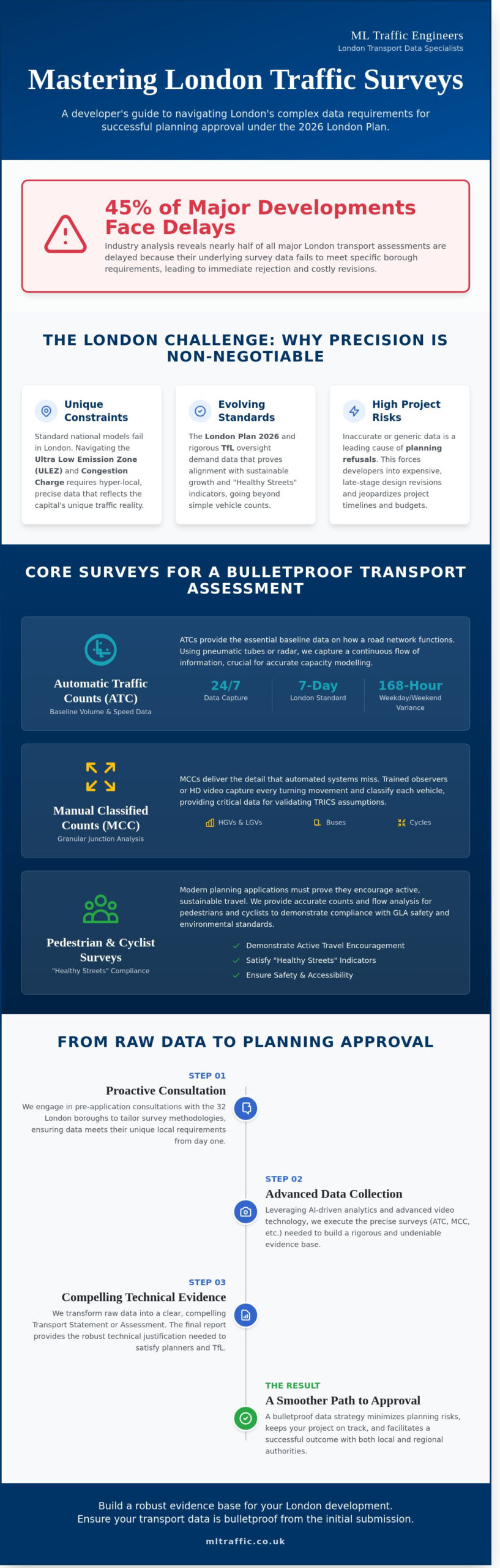
    In 2024, industry analysis showed that nearly 45% of transport assessments for major London developments faced significant delays because the underlying data failed to meet the specific requirements of individual boroughs. When you’re managing a high-stakes project, a single oversight in your traffic surveys can lead to an immediate rejection of your planning application. We understand that the pressure to deliver accurate data is immense, especially when managing the evolving 2026 TfL standards. You need a reliable partner to ensure your transport data is bulletproof from the initial submission.

    You’ve likely experienced the frustration of shifting regulatory goalposts and the high costs of re-doing surveys that don’t meet council scrutiny. This guide will help you master the complexities of London’s transport requirements to secure planning approval with precision. We’ll examine the essential survey types required for 2026 and provide a clear path to satisfying both local and regional authorities. From junction capacity modelling to pedestrian flow monitoring, you’ll learn how to build a robust evidence base that keeps your project on track.

    Key Takeaways

    • Align your development with the London Plan 2026 by understanding how precise transport data underpins successful planning applications.
    • Identify the specific types of traffic surveys required for your project to meet the unique demands of London’s diverse local authorities.
    • Leverage AI-driven analytics and advanced video technology to ensure your data meets the rigorous accuracy standards expected by transport planners.
    • Navigate the complexities of the 32 London boroughs through proactive pre-application consultations and tailored survey methodologies.
    • Transform raw data into compelling technical evidence for Transport Statements that facilitate a smoother path to planning approval.

    Table of Contents

    What Are Traffic Surveys and Why Are They Vital in London?

    Traffic surveys are the systematic collection and analysis of transport data used to quantify how vehicles, cyclists, and pedestrians move through a specific area. In the high-stakes environment of London development, these surveys provide the empirical foundation for every successful planning application. They move beyond simple observation, providing a technical snapshot of road capacity, speed, and volume that local authorities require before any ground is broken.

    The London Plan 2026 sets rigorous standards for sustainable growth, requiring developers to align their transport strategies with borough-level policies. Because London operates under unique constraints like the Ultra Low Emission Zone (ULEZ) and the Congestion Charge, standard national traffic models often fail to capture the reality of the capital’s streets. Precise data is the only way to prove a project won’t negatively impact the city’s complex infrastructure. Relying on outdated or generic data is a significant risk. In 2023, inaccurate transport data remained a leading cause for planning refusals and forced developers into expensive design revisions late in the project lifecycle.

    The Purpose of Data in the Planning Process

    Establishing a baseline for existing conditions is the first step in any development. You must understand how a busy London centre functions during peak hours before introducing new traffic. We utilise various traffic count methodologies to capture high-accuracy data on vehicle classifications and turning movements. This evidence is essential for predicting the future impact of a site on the local road network. It provides the technical justification needed for a Transport Assessment London, ensuring your proposal is seen as viable by planning officers.

    Statutory Requirements and London Authorities

    Transport for London (TfL) maintains strict oversight of the Strategic Road Network. They demand high-quality traffic surveys to ensure network fluidity isn’t compromised. Local highway authorities also rely on this data when negotiating Section 278 agreements, which govern any permanent changes to public roads. Beyond motor vehicles, modern applications must satisfy “Healthy Streets” indicators. This requires accurate counts of pedestrians and cyclists to demonstrate that a development encourages active travel and meets the safety standards required by the Greater London Authority. You can learn more about our comprehensive approach to data collection in our section on what we do for developers across the capital.

    Core Types of Traffic Surveys for London Developments

    London councils demand precise, high-resolution data before they consider a planning application. You can’t rely on guesswork when the GLA’s transport targets are so stringent. Developers must deploy specific traffic surveys that align with the scale of their project and the unique constraints of the local road network. These surveys don’t just count cars; they provide a legal and technical foundation for your Transport Assessment. They also work in tandem with parking surveys to provide a complete picture of site impact.

    Automatic Traffic Counts (ATC) and Link Flows

    ATC surveys provide the baseline volume and speed data for specific road sections. We use pneumatic tubes or radar sensors to capture data 24 hours a day. While a single day might suffice in rural areas, the London standard is a full 7-day survey. This 168-hour window captures the vital variance between weekday commuter peaks and weekend retail traffic. This data ensures your project adheres to road traffic data collection standards, providing the accuracy required for junction capacity modelling. Accuracy here is non-negotiable. It prevents costly delays during the Section 106 negotiation phase.

    Manual Classified Counts (MCC) and Junction Analysis

    MCCs offer the granular detail that automated systems can’t reach. We deploy trained observers or high-definition video mast systems to record every turning movement at key intersections. We classify vehicles into specific categories: cycles, buses, HGVs, and LGVs. This classification is vital for validating TRICS database assumptions. If your development sits near a red route or a sensitive residential junction, the MCC provides the evidence needed to prove your site won’t cause gridlock. It’s a direct, functional way to satisfy the Highways Authority.

    Pedestrian and Cyclist Surveys

    London’s planning policy now prioritises “Active Travel” over private car use. We conduct detailed pedestrian and cyclist surveys to support car-free development goals. Our teams analyse desire lines and crossing usage in high-density areas to ensure safe access. We also assess how your site interacts with existing cycle superhighways or Quietways. Capturing this multi-modal data is essential for modern London applications. It shows you’ve considered the safety of all road users, not just motorists. If you need clarity on which data points your local borough requires, our team offers comprehensive traffic solutions to streamline your application.

    Traffic Surveys in London: A Developer’s Guide to Planning Data in 2026

    Methodologies and Technology: Ensuring Data Precision

    The era of manual tally counters is over. Modern traffic surveys rely on high-precision digital tools to capture every movement on the road. We operate in a 24/7 environment. London traffic never truly sleeps. This requires a robust approach to data collection that can withstand the scrutiny of local planning authorities. Accuracy is the primary hallmark of a professional transport consultancy. It is the difference between a project being approved or stuck in a cycle of costly revisions.

    Video Analytics and AI Data Collection

    High-definition video monitoring is the gold standard for complex multi-way systems and busy urban junctions. These systems use AI-driven analytics to provide automated vehicle classification. They distinguish between HGVs, LGVs, cars, and cyclists with 98% accuracy. The primary advantage of video is the ability to re-audit. If a council officer disputes the results, we review the raw footage to verify every vehicle count. This transparency prevents project delays and ensures your traffic surveys are beyond reproach.

    Radar and Infrared Sensing

    On red routes and high-speed corridors, non-intrusive methods offer a safer and more durable alternative. We deploy radar and infrared sensors that maintain reliability in heavy rain or low-light environments. These sensors don’t require road fixings. This means they are less likely to suffer from mechanical failure compared to pneumatic ATC tubes. They provide consistent speed and volume data throughout the duration of the study. Your planning application should be based on facts, not estimates.

    Queue Length and Delay Studies

    We measure the current saturation levels of London junctions to identify bottlenecks. These issues could be exacerbated by new site traffic. This involves tracking queue lengths and average delays during peak hours. This data is essential for swept path analysis services. By identifying these issues early, we propose bespoke mitigation strategies. We keep your project moving forward by proving the network can handle the additional load.

    All our processes strictly comply with GDPR and privacy regulations in public spaces. We use advanced masking technology. Individual faces and number plates are never identifiable in the final data sets. This commitment to privacy and precision makes us a safe pair of hands. We navigate the complex UK planning landscape so you don’t have to. Our readiness to deploy at short notice ensures your project stays on schedule.

    Planning applications in the capital require a granular approach because the 32 London boroughs rarely share identical technical standards. A survey design that satisfies Camden might face immediate rejection in Croydon. Developers often face significant delays by assuming a generic survey will suffice. We recommend a formal pre-application consultation to define the exact scope of required traffic surveys before deploying equipment on-site. This proactive step prevents the submission of redundant data and ensures your project meets the specific expectations of local highways officers. For projects in South East London, working with experienced Transport Planning Consultants Bromley can be critical to navigating the borough’s specific parking and access standards with precision.

    Timing is everything in London. Data collected during school holidays, bank holidays, or even local half-terms is considered non-representative. Planning officers typically demand data from “neutral” months, specifically avoiding December, August, and late July. If your data includes these periods, it’s likely to be invalidated. This forces a costly re-survey that could push your project timeline back by 12 weeks or more. Our team monitors local school calendars across all boroughs to ensure your data collection window is legally and technically sound.

    The Lambeth Methodology and Parking Stress

    The Lambeth Methodology represents the industry standard for assessing parking stress in London. It requires surveyors to record parking occupancy between 00:30 and 05:30 on two separate weekday nights. This specific window captures peak residential demand when most residents have returned home. You must survey every publicly accessible road within a 200-metre walking distance of the site. If the survey identifies parking stress levels above 80%, the council may require significant changes to your proposal to mitigate the impact on local residents. We deliver these reports with high-precision CAD drawings to illustrate capacity clearly.

    PTAL Ratings and Accessibility Surveys

    Your site’s Public Transport Accessibility Level (PTAL) score dictates the intensity of your survey requirements. High PTAL zones, such as those with scores of 5, 6a, or 6b, often allow for car-free developments. However, these sites require robust travel plans to prove how occupants will move without private vehicles. Conversely, low PTAL areas might require “walk-interval” surveys. These studies measure the time and safety of pedestrian routes to the nearest bus stops or rail stations. We ensure these surveys account for pavement widths and crossing wait times to meet strict Transport for London (TfL) criteria.

    Ensure your project meets local standards by contacting our team for bespoke traffic survey solutions.

    From Raw Data to Planning Approval: The Final Report

    Raw data provides the foundation, but the final report delivers the result. ML Traffic Engineers transform raw counts into technical planning evidence that stands up to rigorous scrutiny from local authorities. We don’t just hand over spreadsheets; we provide a narrative that supports your development goals. This evidence populates the Transport Statements and Transport Assessments required for 95% of major planning applications in the UK. We use this data to justify specific design choices, such as car-park layouts and the positioning of access points. This ensures your site operates safely and efficiently from day one.

    Precision is a legal and physical necessity in this final stage. We cross-reference all traffic surveys against the latest TfL best practice guidance to ensure compliance. This meticulous approach alleviates the regulatory burden on your team. It means your application moves through the system without the delays caused by data queries or requests for resubmission. Working with experienced transport consultants UK developers rely on ensures that every technical report is prepared to the exacting standards required by both local authorities and Transport for London.

    Data Visualisation and Technical Reporting

    We create clear, CAD-ready datasets designed for immediate architectural integration. Our team summarises complex vehicle flows into digestible tables that planning officers can interpret quickly. This clarity is essential when explaining how a new junction will perform during peak hours. We focus on providing a total, managed solution that bridges the gap between raw numbers and site design. You can explore our resources for technical reporting standards that define our high-quality output.

    • Detailed junction capacity modelling using industry-standard software.
    • Visual flow diagrams that illustrate vehicle, pedestrian, and cyclist movements.
    • Bespoke reporting tailored to the specific requirements of your Local Planning Authority.

    Securing Your Planning Consent

    The final report is your primary tool for negotiation. We use the data to prove that a development won’t have a “severe” impact on the road network, a key threshold defined in paragraph 115 of the National Planning Policy Framework (NPPF). This evidence is vital when negotiating mitigated contributions under Section 106 agreements. By proving the actual impact is manageable, we often help clients avoid unnecessary and costly infrastructure levies.

    For developments within Greater London, we ensure every survey aligns with the TfL Healthy Streets indicators and 2024 data collection protocols. We act as a safe pair of hands, understanding UK road regulations so you don’t have to. Learn more about what we do to support London developers in securing consent through accurate, high-speed data delivery. Our 24/7 readiness ensures that even if a planning officer requests additional data at the last minute, we can respond with the urgency your project demands.

    Streamline Your 2026 Planning Application

    Securing planning approval in London requires a meticulous approach to data that satisfies the unique requirements of all 32 boroughs. You’ve seen how precise traffic surveys and advanced methodologies are essential to navigating these regulatory hurdles. Accurate data serves as your project’s foundation, ensuring that every transport assessment is robust enough to withstand scrutiny from local authorities. It’s about more than just numbers; it’s about providing a safe, compliant, and efficient roadmap for your development.

    ML Traffic Engineers offers over 10 years of London planning expertise to help you manage these complexities. With 24/7 data collection capability and a reputation for reliability across the capital, we provide the technical authority your project needs. We’ll manage the entire process from initial consultation to the final report, allowing you to maintain momentum without administrative delays. Our team is ready to deliver the bespoke, high-stakes data required for modern UK infrastructure projects.

    Contact ML Traffic Engineers for a Bespoke Survey Quote

    We look forward to helping you achieve a successful planning outcome for your next London development.

    Frequently Asked Questions

    How long does a typical traffic survey take to complete in London?

    A standard programme for traffic surveys involving Automatic Traffic Counts (ATCs) typically requires seven consecutive days of data collection. Once the site equipment is recovered, data processing and quality assurance checks take approximately three to five working days. This timeline ensures we capture a full weekly cycle, including weekend and weekday variations, to meet Transport for London (TfL) requirements.

    Can I use old traffic data for a new planning application in 2026?

    Local authorities generally reject traffic data that’s more than three years old. If you’re submitting a planning application in 2026, data collected before 2023 will likely be considered obsolete due to shifting post-pandemic travel patterns. We recommend commissioning fresh surveys to ensure your submission reflects current road usage and avoids costly delays during the validation stage.

    What happens if the traffic survey shows high levels of congestion?

    High congestion levels require the development of a robust mitigation strategy or a formal Travel Plan to reduce vehicle trips. You might need to propose infrastructure improvements, such as junction redesigns or Section 106 financial contributions for public transport. Most London boroughs look for a 10% to 15% reduction in peak-hour trips through these sustainable transport measures.

    Do I need a traffic survey for a small-scale residential development?

    You’ll likely need a survey if your project exceeds 10 residential units or is located near a sensitive or over-capacity junction. Even for smaller sites, a Transport Statement is often required to prove the development won’t compromise local road safety. We assess each site’s specific impact to determine if a full traffic surveys suite is necessary for your planning consent.

    How much do traffic surveys cost for a London project?

    Costs for London surveys depend on the number of observation points, the equipment required, and the duration of the study. A single-site Automatic Traffic Count using pneumatic tubes is less resource-intensive than a multi-junction manual turning count involving AI camera technology. We provide bespoke quotes based on your specific borough requirements to ensure you don’t overspend on unnecessary data collection.

    What is a “Neutral Week” and why is it required for London surveys?

    A neutral week is a period excluding school holidays, bank holidays, and seasonal events that might skew traffic data. These weeks typically occur in late spring and autumn, such as May or October. Using these windows is mandatory because it provides a representative baseline of normal traffic conditions, which is essential for accurate impact modelling.

    Is video monitoring allowed under London privacy laws?

    Video monitoring is fully legal provided it complies with the Data Protection Act 2018 and UK GDPR standards. We use high-definition cameras to track vehicle movements, but individual privacy is protected through data anonymisation. Faces and number plates are processed solely for statistical purposes, ensuring your project remains compliant with all UK surveillance regulations.

    How do I know which London borough methodology to follow?

    You must consult the specific Local Plan and Transport Assessment guidelines issued by your local council. While all 32 London boroughs follow the general TfL Transport Assessment Guidance (2014), individual authorities often have unique requirements for cycle parking or construction logistics. We coordinate directly with borough transport officers to ensure our methodology meets their exact technical specifications.

    Which areas do you cover?

    We service Acton, Balham, Barking, Barnes, Barnet, Battersea, Beckenham, Bexleyheath, Brentford, Brixton, Bromley, Camberwell, Carshalton, Charlton, Chelsea, Chiswick, Clapham, Coulsdon, Croydon, Crystal Palace, Dagenham, Dulwich, Ealing, Edgware, Eltham, Enfield, Finchley, Forest Gate, Fulham, Golders Green, Greenwich, Hackney, Hammersmith, Hampstead, Harrow, Hayes, Highgate, Hounslow, Ilford, Islington, Kensington, Kentish Town, Kingston upon Thames, Lewisham, Mitcham, Muswell Hill, New Malden, Notting Hill, Orpington, Peckham, Pinner, Purley, Putney, Richmond, Romford, Ruislip, Sidcup, Southall, Southgate, Streatham, Surbiton, Sutton, Tooting, Tottenham, Twickenham, Uxbridge, Walthamstow, Wembley, West Norwood, Wimbledon, Wood Green, Woolwich, Bethnal Green, Shoreditch, Canary Wharf, Deptford, Leyton, Palmers Green, Stanmore, Upminster, Chislehurst, Erith, Feltham.

    Michael Lee

    Article by

    Michael Lee

    Transport planner with over 35 years’ experience.

    Disclaimer

    The content on mltraffic.co.uk, including all technical articles, guides, and resources, is provided for general informational and educational purposes only. It is not intended to constitute professional advice in traffic engineering, transportation planning, development approvals, or any other technical or legal field.
    While ML Traffic Engineers makes every reasonable effort to ensure the accuracy, completeness, and timeliness of the information published, we do not provide any warranties or representations (express or implied) regarding its reliability, suitability, or availability for any particular purpose. Any reliance you place on the content is strictly at your own risk.
    In no event shall ML Traffic Engineers, its directors, employees, authors, or affiliates be liable for any direct, indirect, incidental, special, consequential, or punitive damages (including, without limitation, loss of profits, data, or business opportunities) arising out of or in connection with the use of, or inability to use, any information provided on this website.
    The articles and guides on this site are not a substitute for engaging a qualified, professional traffic engineer to assess your specific project requirements. For tailored advice, compliance assessments, or traffic engineering services, please contact a competent professional.
    This disclaimer may be updated from time to time without notice. By accessing or using this website, you agree to be bound by the most current version of this disclaimer.