Tag: UK Planning Policy

  • Traffic Impact Assessment: 2026 Developer’s Guide

    Traffic Impact Assessment: 2026 Developer’s Guide

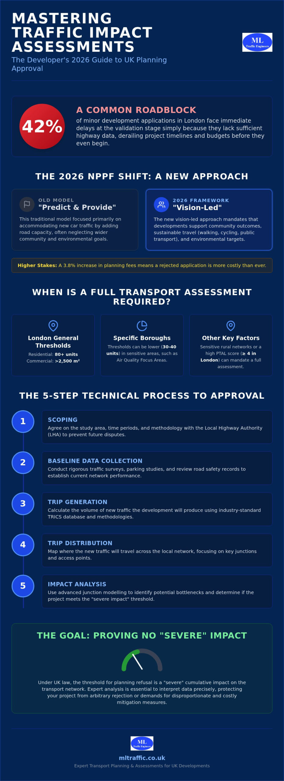
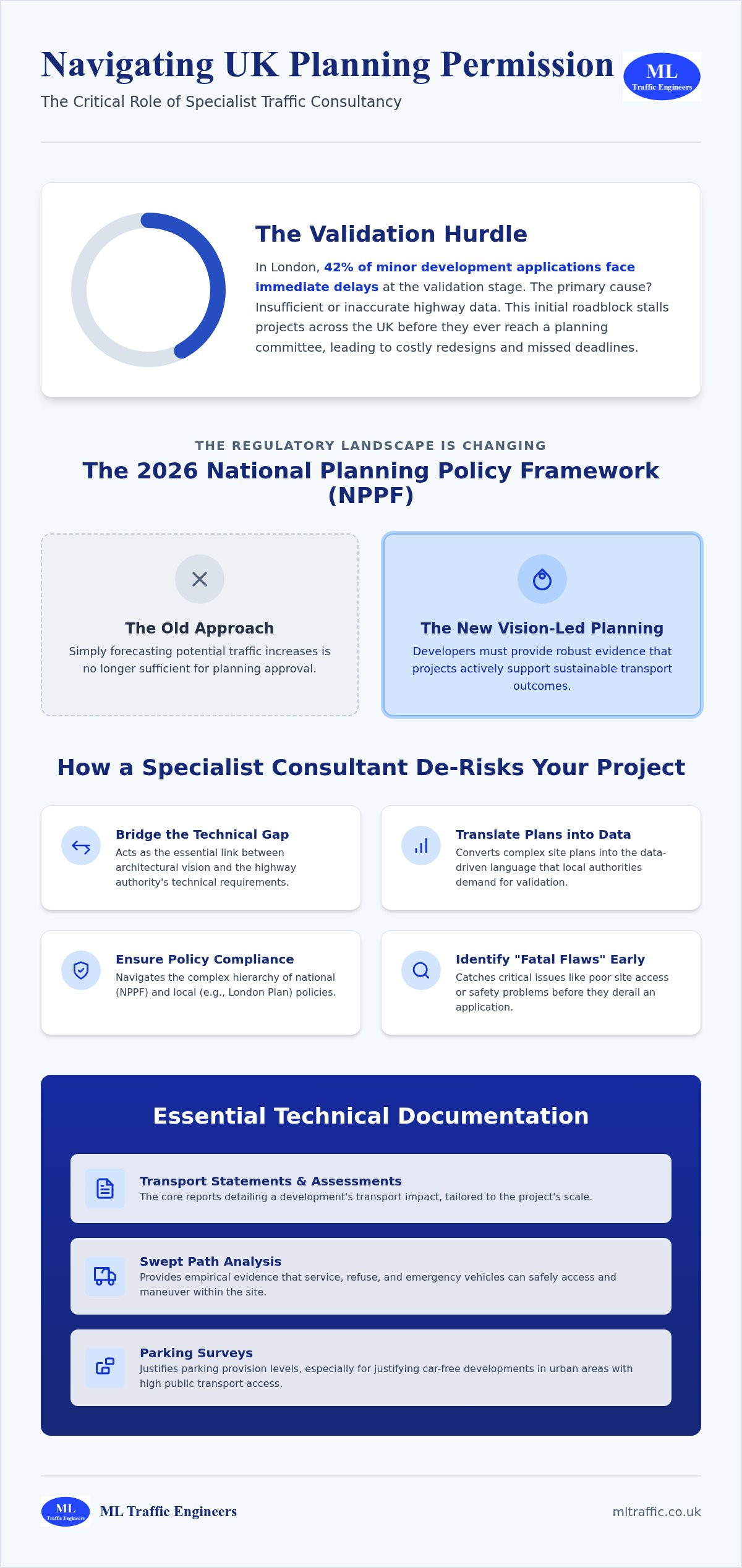
    Did you know that 42% of minor development applications in London face immediate delays at the validation stage simply because they lack sufficient highway data? For developers across the UK, securing a traffic impact assessment for new developments has become a high-stakes hurdle where technical precision is a functional necessity. You’re likely all too familiar with the unpredictable delays from local highway authorities and the soaring costs of unplanned mitigation measures that can derail a project’s budget before it even begins.

    It’s frustrating when regulatory confusion between Transport Statements and full Assessments stalls your progress. This guide provides a clear path to planning approval by mastering the complexities of the 2026 transport planning landscape. We’ll examine the shift toward “vision-led” outcomes in the latest NPPF guidelines and show you how to implement proportionate, cost-effective mitigation strategies. From navigating the recent 3.8% planning fee increase to understanding specific regional thresholds, this comprehensive manual ensures your development remains compliant, reliable, and ready for execution.

    Key Takeaways

    • Establish a clear project scope through early Highway Authority engagement to prevent methodology disputes and validation delays.
    • Identify the specific technical thresholds and regional regulations that determine when you must provide a traffic impact assessment for new developments.
    • Transition from traditional “predict and provide” models to the latest vision-led planning frameworks mandated by the revised 2026 NPPF.
    • Secure planning approval by implementing proportionate mitigation strategies that align with your project’s actual transport footprint.
    • Streamline the planning lifecycle from inception to completion by utilizing expert Transport Assessments and professional data collection.

    Understanding Traffic Impact Assessments in the UK Planning System

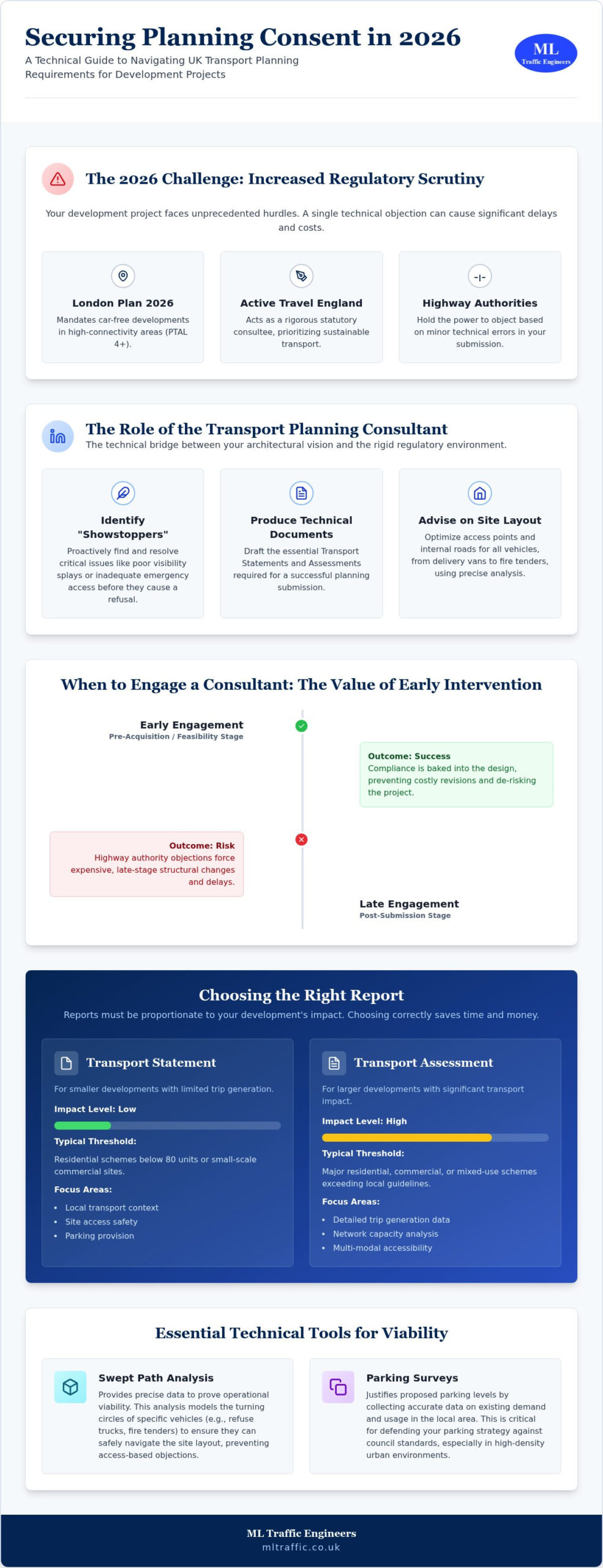
    A traffic impact assessment for new developments is a technical study that evaluates how a proposed project will interact with the existing transport network. It serves as a critical bridge between architectural vision and infrastructure reality. Rooted in the discipline of Traffic engineering, these assessments provide Local Highway Authorities (LHAs) with the necessary data to ensure road safety and network efficiency. While the industry often uses the term “Traffic Impact Assessment” (TIA) as a general descriptor, in the UK planning system, it specifically refers to the technical analysis that underpins a formal Transport Statement or a full Transport Assessment.

    In 2026, the regulatory environment has shifted significantly. The revised National Planning Policy Framework (NPPF) now prioritizes a vision-led approach over the traditional “predict and provide” model. This means your assessment must demonstrate how a development supports specific community outcomes and sustainable travel rather than just adding road capacity for cars. With planning fees in England having increased by 3.8% as of April 2026, the financial risk of a rejected application is higher than ever. Precision in your initial submission is a functional necessity to avoid the costs of rework and delays.

    The Purpose of a TIA: Beyond Simple Congestion

    Assessments don’t just look at traffic jams. They evaluate road safety and accessibility for all transport modes, including pedestrians, cyclists, and public transport users. LHAs use these reports to gauge the cumulative impact of several developments within a single area, ensuring that the local infrastructure can handle the combined pressure of multiple projects. Under UK law, the threshold for planning refusal is a “severe” impact on the transport network. Defining what constitutes “severe” requires professional precision and expert interpretation of data to protect your project from arbitrary rejection or disproportionate mitigation demands.

    When is a TIA Legally Required?

    Requirements for a traffic impact assessment for new developments vary based on scale and location. In London, a full Transport Assessment is typically required for residential sites with 80 or more units or commercial spaces exceeding 2,500 square metres. However, some boroughs have lowered these thresholds to 30 or 40 units, particularly in Air Quality Focus Areas. Even small developments may require a full study if the local network is sensitive or located in a rural area with limited access. Factors like a site’s Public Transport Accessibility Level (PTAL) score also dictate the scope of the study. Sites with a PTAL score of 4 or higher in London are generally mandated to be car-free, which fundamentally changes the methodology of the assessment.

    The 5-Step Technical Process of a Traffic Impact Assessment

    Conducting a traffic impact assessment for new developments requires a methodical approach to ensure regulatory approval. The 5-Step Technical Process begins long before any data is collected on-site. By following a structured sequence, developers can mitigate the risk of local highway authority objections and avoid costly last-minute redesigns. Precision is a functional necessity at every stage to reduce logistical and regulatory pressures.

    • Scoping: You must first agree on the study area, time periods, and assessment methodology with the Local Highway Authority. This prevents fundamental disagreements later in the planning lifecycle.
    • Baseline Data Collection: Our team conducts rigorous Traffic Surveys and parking surveys to establish the current network performance. We also review existing road safety records to identify any pre-existing issues.
    • Trip Generation: We calculate the volume of new traffic the development will produce using industry-standard databases.
    • Trip Distribution: This stage maps where that new traffic will travel across the local network, focusing on key junctions and access points.
    • Impact Analysis: Using advanced junction modelling, we identify potential bottlenecks. This stage is critical for determining if the project meets the “severe impact” threshold discussed previously.

    Utilising the TRICS Database for Accurate Predictions

    The TRICS database is the national standard for trip generation analysis in the UK. It allows us to predict traffic volumes by comparing your project with data from thousands of established sites across the country. Selecting comparable sites is a high-stakes task that requires technical authority. If the chosen data points don’t align with your development’s specific land use or location, the highway authority will likely reject the findings. We ensure your submission is defensible by filtering for precise variables like site size, regional context, and transport accessibility.

    Swept Path Analysis: Proving Site Feasibility

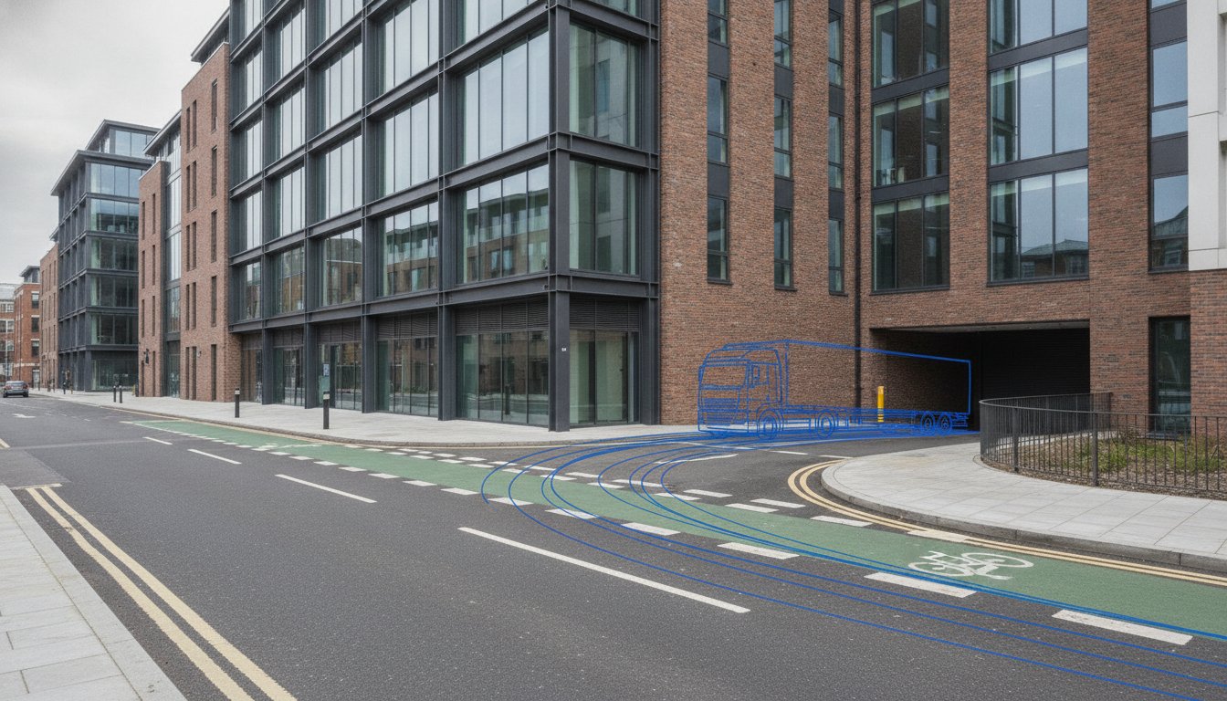
    A successful traffic impact assessment for new developments must prove that the physical site layout is functional. Swept Path Analysis uses AutoTURN software to simulate the movement of large vehicles, such as refuse trucks and fire tenders, through your proposed roads. This technical simulation prevents the logistical pressure of discovering that a vehicle cannot navigate a turn after construction has begun. By identifying these issues during the assessment phase, we help you avoid expensive post-submission redesigns. Ensuring that emergency services and delivery vehicles have unhindered access is a non-negotiable foundation of safety-conscious planning.

    Transport Statement vs. Assessment: Which One Do You Need?

    Determining the appropriate depth of reporting is the first strategic decision in your planning application. A misstep here causes immediate friction with the Local Highway Authority and can lead to unnecessary expenditure. The distinction between a Transport Statement and a full Assessment is primarily defined by the scale of the project and its anticipated trip generation. Selecting the wrong report type often results in the validation stage delays that currently affect 42% of minor development applications in London as of August 2026.

    In the capital, a London-specific Transport Assessment follows stricter criteria set by individual boroughs and the London Plan. These requirements directly impact project timelines, as the level of data scrutiny is significantly higher than in other regions. Early engagement during the pre-application stage is the only way to confirm which report you need. We manage this dialogue for you to ensure the scope is proportionate to your project’s impact, reducing logistical pressure from the start.

    Criteria for a Transport Statement

    A Transport Statement (TS) is a concise report designed for smaller developments with limited transport implications. Typically, this applies to residential projects between 50 and 80 dwellings, though some local authorities set lower thresholds. The TS focuses on immediate site matters: safe access, adequate parking provision, and links to sustainable travel networks. It is often the most cost-effective route for SMEs because it avoids the complex junction modelling required for larger schemes. Precision remains vital; even a shorter statement must satisfy the highway authority’s safety standards to avoid a recommendation for refusal.

    When a Full Transport Assessment is Mandatory

    Developments exceeding 80 residential units or significant commercial floor space require a full Transport Assessment (TA). This is a comprehensive traffic impact assessment for new developments that explores the cumulative effect on the wider transport network. A TA demands multi-modal analysis, evaluating how the project supports cycling, walking, and public transport integration. In 2026, any TA must be accompanied by a Travel Plan. This supporting document outlines long-term strategies to reduce car dependency and promote sustainable transport. Failing to include a robust Travel Plan is a common reason for application deferral under current NPPF guidelines. We ensure your TA includes all necessary technical data to withstand rigorous scrutiny from highway officers.

    Mitigation Strategies and Section 278 Agreements

    Identifying potential bottlenecks in your traffic impact assessment for new developments is only half the battle. The subsequent stage involves defining “proportionate mitigation.” This principle ensures that you only pay for the infrastructure improvements directly necessitated by your project’s impact. Under the 2026 vision-led NPPF framework, the focus has shifted from simply adding road capacity to creating sustainable, safe environments. This shift allows developers to propose a mix of physical and soft mitigation measures that satisfy the Local Highway Authority (LHA) while protecting project margins.

    Physical mitigation involves tangible changes to the road network, such as installing a new roundabout or widening a junction. These works typically fall under a Section 278 (S278) agreement. Developers must account for the high costs associated with these agreements, including technical approval fees and performance bonds. In regions like Worcestershire, technical approval and inspection fees as of June 2026 reach 8% to 10% of the scheme value. A major variable often overlooked is utility diversions, which can constitute 30% to 50% of the total cost for medium-scale schemes. Soft mitigation, conversely, focuses on behavioral changes, often managed through Section 106 (S106) financial contributions to wider transport infrastructure or the implementation of a Travel Plan.

    Negotiating with Local Highway Authorities

    Securing a fair outcome requires professional representation in LHA meetings. Local authorities often request extensive mitigation that exceeds the actual requirements of the development. Our team uses technical evidence from the assessment phase to challenge unreasonable requests. We ensure that any suggested works are strictly necessary and directly related to your site. A well-scoped TIA can limit a developer’s S106 financial liability by proving that specific off-site infrastructure upgrades are not directly necessitated by the proposed scheme. This technical authority reduces regulatory pressure and prevents budget creep.

    Travel Plans: A Tool for Reducing Physical Mitigation

    Modern planning policy prioritizes sustainable travel over road construction. Travel Plans are strategic documents that promote walking, cycling, and public transport use to reduce the total number of vehicle trips generated by a site. By demonstrating a credible reduction in car use, you can often negotiate a decrease in the required physical road improvements. This is particularly effective for Workplace Travel Plans, where employer-led initiatives like car-sharing or cycle-to-work schemes significantly lower peak-hour traffic. Integrating these “soft” measures into your development strategy is a cost-effective way to achieve compliance without the heavy engineering costs of S278 works. If you need to navigate these complex negotiations, view our full range of transport planning services to see how we can assist.

    Traffic Impact Assessment: 2026 Developer’s Guide

    Securing Approval: Why Expert Transport Planning Matters

    Attempting a DIY traffic impact assessment for new developments is a high-stakes strategy that often leads to planning refusal. Inaccurate baseline data or flawed trip generation models provide Local Highway Authorities (LHAs) with immediate grounds for objection. When technical data is scrutinized by planning officers, even minor discrepancies in survey methodology can invalidate an entire submission. Precision is a functional necessity in this environment to protect your investment and maintain your project timeline.

    ML Traffic Engineers has provided expert transport planning support since 2014. We manage the full project lifecycle from inception to final report, reducing the logistical and regulatory pressures on your team. Our approach balances technical authority with a client-focused strategy. We ensure that every traffic impact assessment for new developments we produce meets the strict industry benchmarks and legislative requirements of the 2026 planning landscape. This commitment to formal excellence acts as a vital guardian of your project’s viability.

    The fast-moving nature of infrastructure development requires a partner with a sense of readiness and urgency. Our team remains constantly available to address sudden requests for additional data or technical clarifications from the LHA. This rapid response capability is a hallmark of our service promise. It ensures that your application doesn’t stall due to administrative bottlenecks or technical queries. By positioning ourselves as a comprehensive partner rather than a simple data provider, we navigate the intricate regional regulations so you don’t have to.

    The ML Traffic Advantage: Precision and Reliability

    Our technical lexicon and professional reporting speak the language of local planning officers. We conduct specialized Traffic Surveys and parking surveys that provide a robust evidence base for your application. This data-driven precision allows us to defend your development against unreasonable mitigation requests. We take pride in our adherence to standards, utilizing our expertise in TRICS database analysis and Swept Path Analysis to deliver tailored reports. This all-encompassing service minimizes the risk of validation delays and strengthens your path to approval.

    Next Steps for Your Development

    Engaging a transport consultant early in the concept stage is the most effective way to streamline the planning process. Early involvement allows us to identify potential transport constraints before they become costly obstacles. We provide bespoke documentation that aligns with your specific site requirements and local authority expectations. To secure expert support for your next project, you can contact ML Traffic Engineers for a comprehensive transport planning review. Our team is ready to provide the technical precision and reliable support your development needs to succeed.

    Securing Your Development’s Future with Technical Precision

    The 2026 planning landscape demands a shift from traditional traffic forecasting to outcome-focused, vision-led strategies. Successfully navigating a traffic impact assessment for new developments requires more than just data collection. It necessitates a deep understanding of regional thresholds and the ability to negotiate proportionate mitigation through formal excellence. By establishing a robust technical baseline early in the concept stage, you protect your project from the validation delays and unpredictable costs that frequently stall UK developments.

    Precision is a functional necessity in transport planning. ML Traffic Engineers provides full project lifecycle management, from initial surveys to final submission, ensuring your reporting speaks the language of local planning officers. Our expertise in TRICS database analysis and junction modelling, combined with specialized knowledge in S278 and S38 highway design, reduces the regulatory pressure on your team. Secure your planning approval with ML Traffic Engineers’ expert transport reports. We remain ready to provide the professional, safety-conscious support required to move your project forward with confidence.

    Frequently Asked Questions

    How much does a Traffic Impact Assessment cost for a new development?

    Costs vary based on project scale, site complexity, and the specific requirements of the Local Highway Authority. A residential scheme with 100 units requires more intensive junction modelling than a small commercial unit. Factors like utility diversion investigations and technical approval fees also influence the total budget. This ensures your budget accounts for all necessary technical surveys and regulatory fees. Requesting a project-specific quote is the most reliable approach.

    How long does it take to complete a Transport Assessment in 2026?

    A typical assessment takes between four to eight weeks to complete, depending on the availability of baseline data. This timeline includes the initial scoping with the highway authority, on-site traffic counts, and technical analysis. Complex projects requiring extensive junction modelling or multi-modal studies may take longer. Early engagement is essential to ensure the final report is ready for the validation stage of your planning application. Precision in timing helps avoid unnecessary logistical pressure.

    Can I get planning permission if the TIA shows a significant increase in traffic?

    Yes, provided the impact is not deemed severe under the National Planning Policy Framework and suitable mitigation is proposed. A traffic impact assessment for new developments identifies these increases so that developers can implement improvements like junction upgrades or Travel Plan initiatives. If the proposed mitigation effectively manages the additional volume, the Local Highway Authority is more likely to support the application. Technical precision in your report is a functional necessity here.

    What is the difference between a Traffic Impact Assessment and a Transport Statement?

    The primary difference lies in the scale of the development and the depth of the required technical analysis. A Transport Statement is a concise report for smaller projects with limited transport implications. A full Assessment is a comprehensive study for larger developments that includes detailed junction modelling. The Local Highway Authority typically sets specific thresholds to determine which report type is necessary for a traffic impact assessment for new developments.

    What data is required for a parking survey in a UK planning application?

    Parking surveys must capture the existing parking demand and capacity within a defined area, usually following the Lambeth Methodology in urban settings. Data includes the total number of available spaces, current occupancy levels during peak hours, and any existing parking restrictions. This information proves that the development’s parking provision is adequate and won’t lead to overspill on the local road network. It’s a non-negotiable foundation for safety-conscious planning and regulatory compliance.

    Do I need a Travel Plan if I already have a Traffic Impact Assessment?

    A Travel Plan is almost always required as a supporting document for a full Transport Assessment in 2026. While the assessment identifies the physical impact of traffic, the Travel Plan outlines long-term strategies to encourage sustainable travel. These documents work together to show how the development will reduce car dependency and align with the latest vision-led NPPF guidelines. Integrating both documents demonstrates a commitment to professional integrity and civic responsibility.

    What happens if the Highway Authority objects to my TIA results?

    If an objection occurs, you must enter technical negotiations to address the authority’s concerns. This often involves providing additional data, refining modelling parameters, or proposing more robust mitigation measures. Professional representation is a functional necessity during these meetings to challenge unreasonable requests with technical evidence. Resolving these objections through expert reporting is critical to securing planning approval and avoiding a formal refusal. Our team remains ready to assist with these urgent requirements.

    Is a Swept Path Analysis always required for residential developments?

    Swept Path Analysis is essential for any development where large vehicles, such as refuse trucks or fire tenders, must navigate the site. While not always mandatory for very small infill projects, most Local Highway Authorities require it to prove site feasibility. This technical simulation ensures that emergency services have unhindered access and prevents the logistical pressure of expensive post-construction redesigns. It remains a hallmark of reliable, safety-conscious site planning that adheres to strict industry benchmarks.

    Michael Lee

    Article by

    Michael Lee

    Transport planner with over 35 years' experience.

    Disclaimer

    The content on mltraffic.co.uk, including all technical articles, guides, and resources, is provided for general informational and educational purposes only. It is not intended to constitute professional advice in traffic engineering, transportation planning, development approvals, or any other technical or legal field.
    While ML Traffic Engineers makes every reasonable effort to ensure the accuracy, completeness, and timeliness of the information published, we do not provide any warranties or representations (express or implied) regarding its reliability, suitability, or availability for any particular purpose. Any reliance you place on the content is strictly at your own risk.
    In no event shall ML Traffic Engineers, its directors, employees, authors, or affiliates be liable for any direct, indirect, incidental, special, consequential, or punitive damages (including, without limitation, loss of profits, data, or business opportunities) arising out of or in connection with the use of, or inability to use, any information provided on this website.
    The articles and guides on this site are not a substitute for engaging a qualified, professional traffic engineer to assess your specific project requirements. For tailored advice, compliance assessments, or traffic engineering services, please contact a competent professional.
    This disclaimer may be updated from time to time without notice. By accessing or using this website, you agree to be bound by the most current version of this disclaimer.

  • DfT Transport Assessment Guidance: Key Aspects

    DfT Transport Assessment Guidance: Key Aspects

    Relying on the withdrawn 2007 standards is one of the fastest ways to guarantee a planning refusal in 2026. It’s understandable if you feel overwhelmed by the transition to the current Planning Practice Guidance and local authority expectations. Mastering the official Guidance on Transport Assessment published by the Department for Transport is essential for any developer who needs to meet the National Planning Policy Framework standards updated on February 7, 2025. Technical precision during the pre-application phase prevents expensive logistical bottlenecks and regulatory delays during the decision-taking process.

    This article simplifies the complexities of transport documentation so you can move forward with confidence. You’ll learn how to distinguish between a “lighter-touch” Transport Statement and a full Transport Assessment based on indicative local authority thresholds. We provide a definitive checklist of required content, helping you manage the project lifecycle from initial data collection to final planning approval. By the end, you’ll know exactly how to secure professional reports that satisfy statutory requirements and protect your project’s timeline from unnecessary scrutiny.

    Key Takeaways

    • Navigate the transition from the 2007 guidance to current 2025 NPPF standards to ensure your development remains compliant with the latest regulatory framework.
    • Determine if your project needs a comprehensive technical report or a simplified submission by following the official Guidance on Transport Assessment published by the Department for Transport.
    • Master the core requirements for auditing existing transport networks, including site access, parking provision, and internal site layouts.
    • Learn how to identify and mitigate “severe” transport impacts through strategic Travel Plans and physical network improvements.
    • Build a data-driven strategy that aligns with 2026 Net Zero targets to achieve faster planning approval from local highway authorities.

    The Evolution of DfT Guidance on Transport Assessments

    A Transport Assessment (TA) serves as the primary technical mechanism for evaluating the impact of a proposed development on the highway network. It isn’t just a paperwork exercise; it’s a rigorous, data-driven report required by local planning authorities to ensure public safety and network efficiency. Central to this process is the Guidance on Transport Assessment published by the Department for Transport, which provides the framework for identifying how a project affects local infrastructure and the wider community.

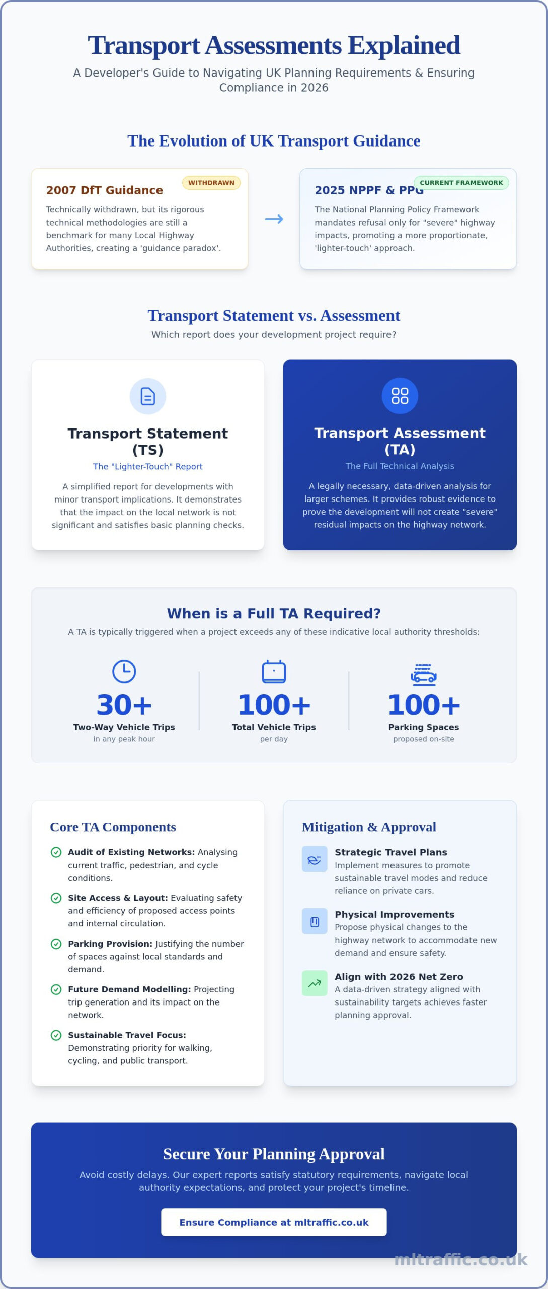
    The regulatory environment shifted significantly in 2014 when the Department for Transport technically withdrew the comprehensive 2007 guidance, moving toward the Planning Practice Guidance (PPG). This transition aimed to make the transportation planning process more proportionate. However, the National Planning Policy Framework (NPPF), last updated on February 7, 2025, remains the ultimate authority. It mandates that development should only be prevented on highway grounds if there’s an unacceptable impact on highway safety or if the residual cumulative impacts on the road network would be severe.

    To better understand this concept, watch this helpful video:

    Understanding the Guidance Paradox

    The industry currently operates under a paradox. While the official 2007 Guidance on Transport Assessment published by the Department for Transport was archived, its technical methodologies remain the gold standard for traffic modelling and data analysis. Local highway authorities frequently expect the depth of detail found in the legacy document, even though current PPG suggests a “lighter touch.” ML Traffic Engineers bridges this gap by applying modern PPG principles while maintaining the technical rigour demanded by local officers. We navigate these conflicting expectations to ensure your Transport Assessments meet both statutory requirements and local preferences without unnecessary delays.

    The Purpose of the Assessment for Developers

    For a developer, the assessment is a strategic tool rather than a hurdle. It identifies potential capacity issues before they become grounds for refusal. A compliant report demonstrates a clear priority for sustainable travel modes, such as walking and cycling, over private car use. This alignment with government policy is crucial for securing approval. By auditing existing conditions and projecting future demand, we help clients mitigate safety risks early in the design phase. This proactive approach reduces the likelihood of expensive post-submission redesigns or the rejection of planning applications due to insufficient transport data.

    Transport Statements vs. Assessments: Determining Your Requirements

    A Transport Statement (TS) is a simplified report designed for developments with limited transport implications. In contrast, a full Transport Assessment (TA) is a legal necessity for larger schemes to prove that the development won’t create “severe” residual impacts on the highway. The Current Government Guidance on Transport Assessments clarifies that the level of detail in these documents must always be proportionate to the scale and complexity of the project. Understanding which path to take is the first step in ensuring your planning application isn’t stalled by technical objections.

    Adhering to the Guidance on Transport Assessment published by the Department for Transport is vital when negotiating with Local Highway Authorities (LHAs). While the LHA makes the final determination on a case-by-case basis, certain indicative thresholds usually trigger a full assessment. These typically include developments generating 30 or more two-way vehicle movements in any peak hour, projects generating 100 or more movements per day, or any site proposing 100 or more parking spaces. If your project falls below these levels, a Transport Statement is often sufficient to satisfy the planning officer.

    Threshold Analysis for 2026 Developments

    Gross Floor Area (GFA) often serves as the initial trigger for residential, retail, and industrial sites. However, modern planning focuses heavily on cumulative impact. Even if your site falls below standard thresholds, an assessment might be required if the local junction is already operating near capacity. For example, a small residential development in a congested urban centre may require a full TA where a similar site in a rural area would only need a Statement. It’s about the sensitivity of the local network, not just the physical size of your building.

    The Scoping Process: Avoiding Unnecessary Work

    Early engagement through a formal scoping exercise prevents wasted resources on irrelevant data collection. During this stage, you must agree on the “Study Area” with the highway authority to determine exactly which junctions require modelling. You’ll also define “Assessment Years,” typically comparing the opening year against a 5 or 10-year post-completion horizon to account for long-term traffic growth. Getting these details right from the start is essential for a smooth planning journey.

    You can learn more about our Transport Planning and Assessment Reports to see how we handle these technical negotiations. Our team ensures that the scope of work is strictly limited to what’s necessary for compliance, saving you both time and professional fees. If you’re currently preparing a planning submission, securing an early agreement on the scope is the most reliable way to prevent expensive revisions later in the process.

    DfT Transport Assessment Guidance: Key Aspects

    Core Components of a Compliant Transport Assessment

    A robust planning submission relies on a logical sequence of evidence. The Guidance on Transport Assessment published by the Department for Transport mandates a clear audit of the existing transport network before any modelling begins. This involves evaluating current safety records, public transport accessibility, and infrastructure capacity within the study area agreed upon during the scoping phase. Without a precise baseline, the local highway authority cannot accurately measure the impact of your proposed development.

    Predicting future traffic flows requires the use of the TRICS database. This industry-standard tool allows us to calculate trip generation based on data from comparable sites across the country. We don’t just guess numbers; we use verified data to model how many vehicle, pedestrian, and cycle movements your site will produce. This analysis forms the foundation of junction capacity tests. We examine the Ratio of Flow to Capacity (RFC) to ensure no local junction becomes overloaded, keeping your project in line with NPPF safety standards.

    Detailing the internal layout involves more than just drawing parking bays. We must demonstrate that site access is positioned to maintain visibility splays and that pedestrian routes don’t conflict with heavy vehicle movements. Precision during this stage reduces the risk of the local highway authority requesting expensive redesigns after you’ve already submitted your application. It’s about proving that the site is functional from day one.

    Technical Data and Traffic Surveys

    Accurate Parking Surveys are essential when justifying reduced car provision in urban areas. These surveys prove that existing street capacity can handle any potential overspill, preventing objections based on local congestion. We also conduct comprehensive Traffic Surveys to establish real-time baseline flows. High-quality data prevents local councils or residents from challenging the validity of your technical report during the public consultation phase.

    Swept Path Analysis: Proving Site Feasibility

    Adhering to the Guidance on Transport Assessment published by the Department for Transport ensures that your swept path analysis meets the rigorous safety standards expected by statutory consultees. Our Essential Guide to Swept Path Analysis explains how digital modelling verifies vehicle manoeuvrability. We use specific templates for fire tenders and refuse vehicles to secure technical approval from highway officers. If a large vehicle can’t safely enter and exit your site in a forward gear, the layout will likely face a swift planning refusal.

    Mitigation Strategies and Travel Planning

    If your technical analysis identifies capacity or safety issues, you must propose robust mitigation strategies. The National Planning Policy Framework (NPPF) specifies that planning permission should only be refused on highways grounds if the residual cumulative impacts on the road network are severe. The Guidance on Transport Assessment published by the Department for Transport provides the technical foundation for determining which mitigation measures are proportionate to the scale of your development. Our role is to ensure these measures are technically feasible and cost-effective before they’re formalised in legal agreements.

    Mitigation often involves a combination of physical infrastructure and management strategies. Physical works, such as junction improvements or the installation of new pedestrian crossings, are typically secured through Section 278 agreements. Financial contributions toward wider network improvements or public transport enhancements fall under Section 106 obligations. Negotiating these agreements requires a high level of technical precision. We provide the data necessary to ensure that the scope of these works remains directly related to the impact of your site, preventing unnecessary financial overreach.

    Sustainable Mitigation Measures

    Modern planning policy prioritises active travel over traditional road widening. We design mitigation packages that focus on improving walking and cycling routes to reduce the need for car-based trips. This includes integrating electric vehicle (EV) charging infrastructure and high-quality cycle storage into the initial site design. For a deeper dive into the technical requirements for infrastructure delivery, see our guide on Navigating Highway Design S278 & S38. These sustainable measures often carry more weight with planning officers than simply adding road capacity.

    Effective Travel Plans for Planning Success

    A Travel Plan is a long-term management strategy that accompanies your assessment to promote sustainable transport. It must include SMART targets for modal shift, such as reducing single-occupancy vehicle trips by a specific percentage over five years. Local authorities now demand clear monitoring and enforcement mechanisms to ensure these targets are met. You can find more detail in our London Travel Plans: The Essential Guide. A well-structured plan acts as a safeguard, providing the council with the confidence that the development’s impact will be managed effectively throughout its lifecycle.

    Our team specializes in delivering compliant documentation that bridges the gap between technical assessment and practical mitigation. If you’re facing potential objections due to traffic impact, contact us for expert Transport Assessment and Travel Plan services to secure your planning approval.

    Securing Planning Approval with ML Traffic Engineers

    Success in modern planning requires more than just submitting a technical report. It demands a data-driven strategy that anticipates the scrutiny of local highway officers. By following the Guidance on Transport Assessment published by the Department for Transport, we provide the technical evidence needed to overcome objections before they stall your project. Our approach focuses on precision. We eliminate the guesswork that often leads to planning delays or expensive requests for further information. We ensure every data point stands up to rigorous cross-examination by statutory consultees during the public consultation phase.

    The 2026 planning landscape has evolved significantly. Net Zero and Vision Zero targets are no longer optional considerations; they’re central to how assessments are judged by local authorities. Planners now prioritize developments that actively contribute to decarbonization and absolute road safety. We integrate these mandates into every report, proving through rigorous analysis that your project aligns with the latest government standards. This proactive alignment reduces the logistical and regulatory pressures on your team, allowing you to focus on the broader aspects of your development while we handle the technical complexities.

    The ML Traffic Advantage: Accuracy and Speed

    We manage the full project lifecycle. From the initial scoping meeting with the Local Highway Authority (LHA) to final technical approval, our team provides constant support and unwavering reliability. This “inception to completion” philosophy ensures that the transport strategy remains consistent even as the site design evolves. We understand the specific nuances of London-specific policies and regional England requirements. Our experts act as a reliable partner, managing intricate regional regulations so you don’t have to. You can explore our project types and expertise to see how we’ve secured approvals across diverse residential and commercial sectors.

    Ensuring Regulatory Compliance in 2026

    Adhering to the latest “Decarbonising Transport” mandates is a non-negotiable foundation of our work. We use the Guidance on Transport Assessment published by the Department for Transport to frame our safety and capacity arguments. Our technical authority reduces your project risk by providing a shield against regulatory pressure. We don’t just provide a document; we act as your professional representative in high-stakes negotiations with highway officers. Our focus on providing an all-encompassing, fully-managed service ensures that your transport documentation is resilient, compliant, and ready for immediate action.

    Get a Transport Assessment Quote for your project today to ensure your submission meets every statutory requirement and accelerates your timeline to planning approval.

    Streamline Your Planning Journey with Expert Transport Documentation

    Navigating the modern planning landscape requires a technical partner who understands the nuances of regulatory change. You’ve seen how the shift from legacy standards to the current NPPF requires a precise application of the Guidance on Transport Assessment published by the Department for Transport. Identifying the correct thresholds for your development and implementing robust mitigation strategies are the primary ways to avoid costly planning delays and technical objections.

    Since 2014, ML Traffic Engineers has delivered over a decade of planning success for developers across England and London. We specialize in high-precision Swept Path Analysis and TRICS modelling to ensure every report meets the strictest highway authority standards. Our deep understanding of regional transport policy allows us to reduce your project risk and accelerate approval timelines. Contact ML Traffic Engineers for a DfT-compliant Transport Assessment to secure your project’s future. We’re ready to help you turn complex technical requirements into a successful planning outcome.

    Frequently Asked Questions

    Is the 2007 Guidance on Transport Assessment still valid in 2026?

    Technically, the 2007 document was withdrawn and replaced by Planning Practice Guidance (PPG) in 2014. However, local highway authorities still rely on its detailed technical frameworks for traffic modelling and data presentation. Most professionals treat the 2007 methodologies as the industry standard for high-stakes technical reports today.

    What is the difference between a Transport Assessment and a Transport Statement?

    A Transport Statement is a simplified report for developments with minor transport impacts, while a Transport Assessment is a comprehensive technical study for larger projects. Statements focus primarily on local site access and safety. Assessments require deeper analysis of junction capacity and wider network impacts over a 5 to 10-year horizon.

    How do I know if my development requires a Transport Assessment?

    The requirement depends on the scale of your project and specific local planning authority thresholds. Typically, any development generating over 30 two-way vehicle movements in a peak hour requires a full report. You should refer to the Guidance on Transport Assessment published by the Department for Transport to determine if your specific land use triggers this necessity.

    What is the “Study Area” in a Transport Assessment?

    The Study Area is the specific geographic region where the development’s traffic impact is measured. This usually includes the site access points and any local junctions that might experience a significant increase in traffic. You must agree on this area with the Local Highway Authority during the initial scoping stage to avoid wasted modelling effort.

    Can a Transport Assessment be used to justify zero parking on a site?

    Yes, an assessment can justify low or zero parking by proving high public transport accessibility and utilizing detailed parking surveys. We use data to show that any potential overspill won’t negatively affect local road safety or capacity. This evidence is crucial for developments in dense urban centers where car-free living is prioritized.

    How long does it take to prepare a DfT-compliant Transport Assessment?

    Preparation time varies based on the complexity of the site and the need for fresh traffic surveys. A standard report often takes several weeks to complete, accounting for data collection, modelling, and authority scoping. Engaging an expert early ensures that the technical analysis stays on track with your planning submission deadlines.

    What happens if my Transport Assessment shows a negative impact on traffic?

    If the assessment identifies a negative impact, you must propose mitigation measures to reduce the effect to an acceptable level. Under the NPPF, planning refusal only occurs if the residual cumulative impacts are severe. Mitigation might include physical junction improvements or enhanced sustainable travel options secured through Section 106 or Section 278 agreements.

    Do I need a separate Travel Plan if I have a Transport Assessment?

    Larger developments usually require a Travel Plan alongside the main assessment. While the assessment identifies the technical impact, the Travel Plan serves as a long-term management strategy to encourage sustainable transport modes. The Guidance on Transport Assessment published by the Department for Transport suggests integrating these documents to provide a complete picture of site accessibility.

    Michael Lee

    Article by

    Michael Lee

    Transport planner with over 35 years’ experience.

    Disclaimer

    The content on mltraffic.co.uk, including all technical articles, guides, and resources, is provided for general informational and educational purposes only. It is not intended to constitute professional advice in traffic engineering, transportation planning, development approvals, or any other technical or legal field.
    While ML Traffic Engineers makes every reasonable effort to ensure the accuracy, completeness, and timeliness of the information published, we do not provide any warranties or representations (express or implied) regarding its reliability, suitability, or availability for any particular purpose. Any reliance you place on the content is strictly at your own risk.
    In no event shall ML Traffic Engineers, its directors, employees, authors, or affiliates be liable for any direct, indirect, incidental, special, consequential, or punitive damages (including, without limitation, loss of profits, data, or business opportunities) arising out of or in connection with the use of, or inability to use, any information provided on this website.
    The articles and guides on this site are not a substitute for engaging a qualified, professional traffic engineer to assess your specific project requirements. For tailored advice, compliance assessments, or traffic engineering services, please contact a competent professional.
    This disclaimer may be updated from time to time without notice. By accessing or using this website, you agree to be bound by the most current version of this disclaimer.