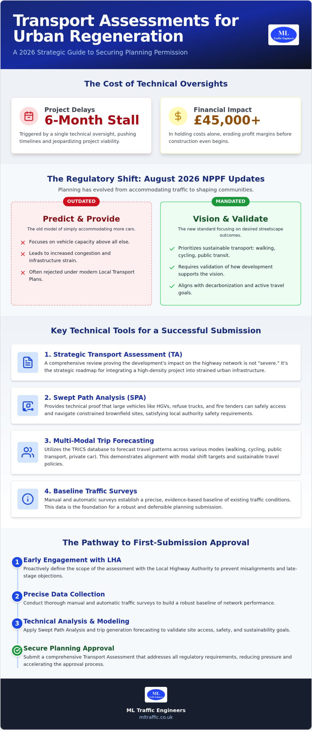
Did you know that a single technical oversight in a transport assessment for a major London development can trigger a six-month stall and over £45,000 in holding costs? In the high-stakes world of urban development, your transport assessment for urban regeneration is no longer just a box-ticking exercise; it’s a critical strategic tool. You likely feel the pressure of the August 2026 NPPF updates and the “vision-led” mandates that demand more than just traffic counts. It’s frustrating to see high-density potential slashed because of rigid local authority requirements or limited physical space for vehicle access.
This 2026 guide shows you how to navigate these complex regulatory landscapes to secure planning permission on your first submission. We’ll explore how to optimize your site layout for maximum density while meeting the latest safety standards and reducing Section 106 contribution costs. From mastering the new London Plan “car-free” mandates to utilizing advanced swept path analysis, you’ll gain the technical insights needed to move from initial assessment to successful execution without costly delays. We have structured this guide to help you manage the full project lifecycle with precision and confidence.
Key Takeaways
- Understand how a transport assessment for urban regeneration acts as a strategic roadmap to manage infrastructure loads and satisfy strict statutory requirements on brownfield sites.
- Learn how technical tools like Swept Path Analysis (SPA) prove that high-density sites can safely accommodate HGVs and emergency vehicles despite narrow access points.
- Discover the process of forecasting multi-modal trip generation to prioritize sustainable travel and meet evolving local authority modal shift targets.
- Identify the critical role of manual and automatic traffic surveys in establishing a precise baseline for successful planning submissions.
- Explore how integrating comprehensive reporting into your project lifecycle reduces regulatory pressure and accelerates the planning approval process.
The Role of Transport Assessment in Successful Urban Regeneration
A Transport Assessment (TA) is a technical report providing a comprehensive review of a development’s impact on the surrounding highway network. For developers, a transport assessment for urban regeneration is a vital strategic document. It goes beyond simple traffic counts to evaluate how high-density projects integrate into the existing urban fabric. Unlike greenfield sites that start with a blank slate, regeneration projects must account for an already strained infrastructure load. The core objective is to demonstrate to the Local Highway Authority (LHA) that any residual cumulative impact on the road network is not “severe”, a threshold defined within national policy.
Effective transportation planning ensures that sites remain viable without compromising public safety or local traffic flow. This process identifies the necessary infrastructure improvements to support increased density while maintaining network efficiency.
Why Regeneration Projects Face Stricter Scrutiny
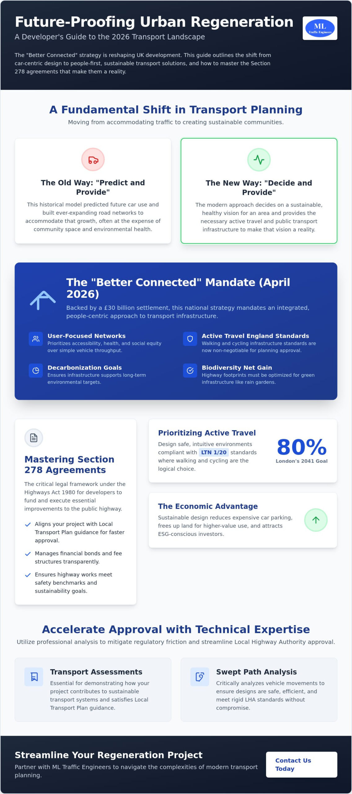
Urban sites often feature high-density residential or mixed-use units that significantly increase pressure on local junctions. Many local authorities now adopt a “no-net-increase” traffic philosophy. This means developers must prove their project won’t add more vehicles to an already congested area. As of August 2026, the industry has shifted toward “Vision and Validate” methodologies. This replaces the outdated “Predict and Provide” model. Instead of just trying to accommodate more cars, we now focus on defining the desired outcome for the streetscape. We validate how the development supports that vision through sustainable travel and active infrastructure.
The Legal Framework: NPPF and Local Transport Plans
The updated National Planning Policy Framework (NPPF), published in August 2026, structures transport policies under chapters TR1 to TR8. These mandates prioritize sustainable transport modes like walking, cycling, and public transport in urban centers. When you submit a TA, the LHA reviews it against their specific Local Transport Plan (LTP). New statutory guidance released in April 2026 requires these plans to be “vision-led,” focusing on decarbonization and active travel. This framework demands a more sophisticated approach to data than in previous years.
Early engagement with the LHA is essential to define the assessment’s scope. This proactive step prevents technical oversights that lead to costly delays. For projects in the capital, our transport assessment guide for London provides deeper insight into managing these regional intricacies. By using the TRICS database to forecast multi-modal trip generation, we provide a robust evidence base that aligns with current legislative requirements. This precision ensures your project meets the high standards expected in modern urban renewal.
Navigating the Complexities of High-Density Urban Site Access
Urban regeneration often involves redeveloping land with restricted footprints and heritage constraints. These sites frequently feature narrow access points that weren’t designed for modern HGVs or emergency vehicles. A transport assessment for urban regeneration must address these physical limitations head-on to prevent planning refusals. Balancing the needs of high-density residential units with safe vehicle movement is a technical challenge that requires precise data and innovative design. Developers must prove that increased density won’t compromise the safety of the existing streetscape or lead to illegal parking on the local highway.
Optimising Access in Constrained Brownfield Sites
Using existing highway junctions is often the most cost-effective route for brownfield developers. It avoids the high costs of Section 278 works and complex utility diversions. However, this requires demonstrating that visibility splays meet current safety standards without encroaching on third-party land. We prioritize pedestrian desire lines to ensure the site remains walkable and safe for all users. To confirm that refuse trucks and fire tenders can navigate these tight spaces, we utilize Swept Path Analysis. This technical proof is essential for validating access feasibility on constrained plots where every square metre of land is valuable.
Managing Servicing and Delivery Logistics
The rise of e-commerce has fundamentally changed urban logistics. Modern regeneration projects require dedicated, off-street loading bays that don’t obstruct the main highway or cycle lanes. According to official government guidance, developers should integrate delivery and servicing plans early in the design process to avoid retrofitting expensive solutions. In mixed-use developments, we often use data to justify shared servicing spaces, which maximizes the available development area. By carefully analyzing delivery timing, we can mitigate the impact on the highway network during peak hours.
This data-driven approach is vital for sites in areas with a Public Transport Accessibility Level (PTAL) score of 4 or higher, where the London Plan 2026 mandates car-free developments. These projects must prioritize active EV charging points for any permitted spaces while ensuring that emergency vehicles maintain unhindered access. If you’re dealing with a particularly tight site, our team can help you optimize your site layout to meet these strict safety and density requirements while ensuring long-term operational viability.
Evaluating Sustainable Transport and Modal Shift Requirements
Modern planning frameworks demand a hierarchy of transport that favors active travel over private vehicles. A systematic review of sustainable transport highlights that successful regeneration depends on this fundamental modal shift. A transport assessment for urban regeneration must provide clear evidence of how a development will encourage walking, cycling, and public transport use. This is not just about policy compliance; it’s about creating viable, high-density spaces that function without overwhelming the local road network. Local authorities now prioritize projects that demonstrate a clear reduction in car dependency from the outset.
Trip Generation and the TRICS Database
To predict how residents and visitors will move, we use comparative data from existing developments. TRICS is the industry-standard database for trip rate analysis. We select comparable sites based on location, land use, and accessibility to establish a realistic baseline for future movements. For urban centers, we adjust this data to reflect “car-free” or “low-car” policies, ensuring the forecast matches the project’s vision. Accurate multi-modal trip generation data prevents the over-provision of parking and justifies higher building densities. This technical precision ensures your transport assessment for urban regeneration remains robust under highway authority scrutiny.
Active Travel and Infrastructure Contributions
The introduction of “Active Travel England” standards has raised the bar for modern regeneration planning. Every assessment must now demonstrate high-quality infrastructure for non-motorized users, such as wider footways and segregated cycle lanes. This often involves negotiating Section 106 contributions for off-site improvements, including cycle path upgrades or enhanced bus stops. In the capital, the Public Transport Accessibility Level (PTAL) score is a decisive factor in these negotiations. You can refer to our Transport Assessment London guide for city-specific PTAL insights and how they influence parking permits and density limits.
A robust Travel Plan acts as a vital companion to the main assessment. It outlines the long-term management strategies to maintain the promised modal shift once the site is occupied. This includes measures like car clubs, subsidized transit passes, or secure cycle storage. Engaging Travel Plan consultants early ensures these initiatives are both practical and acceptable to the Local Highway Authority. This comprehensive approach reduces regulatory friction and helps secure planning approval by proving the development’s long-term sustainability and safety.
Technical Data: Traffic Surveys and Swept Path Analysis for Brownfield Sites
Technical precision is the backbone of any successful planning submission. We use manual and automatic traffic counts (ATC) to establish a clear baseline of current highway activity. This ensures your transport assessment for urban regeneration reflects real-world conditions rather than generic assumptions. Automatic Traffic Counters typically record data over a full seven-day period. This captures the variance between weekday morning commutes and weekend leisure trips. By establishing this granular baseline, we avoid the trap of “over-engineering” highway improvements. Accurate data prevents you from paying for unnecessary junction upgrades that don’t actually serve the project’s needs.
The Critical Role of Swept Path Analysis
Swept Path Analysis (SPA) provides the technical proof that a site layout is functional. Using AutoTURN software, we simulate vehicle movements through tight urban corners and narrow site entrances. This is especially critical for brownfield sites with fixed boundaries and repurposed land. Fire tender access is a non-negotiable safety requirement for every local authority. If you can’t prove a fire engine can reach every part of the development, the project won’t pass the initial planning stages. We also simulate refuse HGVs to ensure waste collection is seamless. You can access specialized ML Traffic Engineers services to ensure your site accommodates these essential vehicles without compromising your building footprint.
Parking Surveys and Stress Tests
Urban regeneration often requires “low-car” or “car-free” strategies to maximize high-density residential space. To justify these, we conduct parking surveys using industry-standard techniques like the Lambeth Methodology. These surveys measure “parking stress” by counting available spaces within a 200-metre radius of the site. We perform these counts during peak residential hours, usually between midnight and 5:00 AM, and during commercial peaks. This data proves that any potential overspill parking won’t negatively affect highway safety or local amenity. If you can prove that local street capacity remains under 85% during peak hours, you have a much stronger case for reducing on-site parking provision. These stress tests provide the evidence needed to satisfy skeptical highway officers.
Secure your planning baseline and avoid costly technical revisions by booking a professional traffic survey today to support your submission.
Securing Planning Approval with ML Traffic Engineers
Professional transport planning is the bridge between a conceptual design and a functional, high-density development. A transport assessment for urban regeneration serves as your technical defense against planning objections and highway authority scrutiny. We don’t just provide a document; we act as technical advocates who understand the intricate regional regulations of the UK’s urban centers. By positioning our experts as partners in your design process, you ensure that every aspect of the site’s mobility is optimized for both density and safety from the earliest stages.
From Inception to Planning Approval
The journey toward a successful submission begins with initial site feasibility. We identify potential access or capacity issues before they become expensive roadblocks. Our sequential flow moves from comprehensive data collection—including parking surveys and swept path analysis—to the final expert reporting. Managing these integrated services under one roof eliminates the communication gaps that often lead to technical inconsistencies in planning applications. This unified approach ensures that the data establish a rock-solid baseline for the entire submission.
Once the report is submitted, our role shifts to managing technical communication with local highway officers. Highway authorities frequently raise post-submission queries regarding modal shift targets or junction capacity. We address these technical challenges directly, providing the evidence-based responses needed to smooth the path toward planning approval. This active management reduces the regulatory pressure on your team, allowing you to focus on the broader aspects of the regeneration project while we handle the technical intricacies of the highway network.
Why Technical Precision Matters in 2026
Planning laws in 2026 are increasingly complex, with a heavy focus on “Vision and Validate” methodologies and strict decarbonization targets. Non-compliance results in more than just delays; it leads to significant holding costs and professional fees that can erode project margins. Professional reports build essential trust with planning committees and local communities by demonstrating a commitment to public safety and sustainable growth. When a transport assessment for urban regeneration is backed by precise data, it becomes much harder for stakeholders to mount a successful objection.
Technical precision ensures that your site layout is optimized for maximum density without sacrificing operational safety or emergency access. We take pride in our adherence to industry benchmarks and legislative requirements, providing a reassuring level of detail that highway officers respect. We invite you to consult with ML Traffic Engineers for your next regeneration project to ensure your submission meets every regulatory benchmark with unwavering reliability and professional excellence.
Unlocking High-Density Potential through Technical Precision
Securing planning permission for high-density projects requires a shift from traditional traffic modeling to a vision-led approach. You’ve seen how technical benchmarks like Swept Path Analysis and parking stress tests provide the evidence needed to satisfy local highway authorities. A robust transport assessment for urban regeneration doesn’t just list impacts; it offers strategic solutions for constrained brownfield sites. By integrating technical data with sustainable travel strategies, you protect your project from the high costs of planning delays and professional fee overruns.
Since 2014, ML Traffic Engineers has specialized in technical reports that navigate complex London and England planning regulations. Our team manages the full project lifecycle, from initial traffic surveys to post-submission negotiations with highway officers. We provide comprehensive support, including SPA and Parking Surveys, to ensure your development remains both safe and compliant. Get a Professional Transport Assessment Quote today to accelerate your planning submission. We’re ready to help you transform urban spaces into sustainable, high-density communities with total confidence.
Frequently Asked Questions
What is the difference between a Transport Statement and a Transport Assessment for regeneration?
A Transport Statement is a concise report for smaller developments with limited traffic impact. In contrast, a transport assessment for urban regeneration is a detailed technical document required for larger, high-density projects that significantly affect the highway network. The threshold for an assessment usually starts at 80 residential units in London. We use these reports to provide a comprehensive analysis of multi-modal trip generation and network capacity to satisfy local authority requirements.
How long does it take to complete a transport assessment for an urban site?
Completing a report typically takes between 4 and 8 weeks. This timeline includes the initial site visit, data collection through traffic surveys, and the technical modeling phase. More complex brownfield sites requiring detailed junction analysis or extensive swept path analysis might take longer to ensure every regulatory benchmark is met. We prioritize accuracy during this phase to prevent project delays during the local authority’s statutory review period.
Is a transport assessment required for car-free developments?
Yes, a transport assessment for urban regeneration is mandatory even for car-free sites. While you might not provide resident parking, the development will still generate trips from delivery vehicles, visitors, and emergency services. The assessment proves that the local infrastructure can handle these movements and confirms the site’s high Public Transport Accessibility Level (PTAL). It also justifies the car-free status by demonstrating the feasibility of sustainable travel alternatives.
What happens if the transport assessment shows a negative impact on local traffic?
If an assessment identifies a negative impact, we propose mitigation measures to reduce the residual cumulative effect. These measures might include optimizing site access, funding local junction improvements, or implementing a robust Travel Plan to encourage a modal shift. The goal is to demonstrate that the impact is not “severe” as defined by the NPPF. We work directly with highway officers to find cost-effective solutions that secure planning approval while maintaining safety.
Can I use a transport assessment to reduce my Section 106 contributions?
You can often reduce Section 106 costs by providing precise technical data. Accurate traffic surveys frequently reveal that a development’s actual impact is lower than the generic estimates used by local authorities. By proving a smaller impact, we can negotiate lower financial contributions for highway works or public transport upgrades. This evidence-based approach prevents the over-engineering of improvements and ensures you only pay for the infrastructure your project truly requires.
What specific vehicle types must be included in a Swept Path Analysis for urban sites?
Swept Path Analysis must include the largest vehicles expected to access the site. This typically covers a standard 11.2m or 12.2m refuse collection vehicle and a standard fire tender. For mixed-use regeneration projects, we also simulate 7.5t or 10m delivery vehicles to ensure loading bays function correctly. Proving these vehicles can maneuver safely through tight urban corners is a non-negotiable safety requirement for securing planning permission on constrained brownfield plots.
How often do I need to update the traffic data for a planning resubmission?
Traffic data generally remains valid for 18 to 36 months depending on the local highway authority’s specific policies. If your planning application is delayed or you are resubmitting after three years, you’ll likely need fresh traffic surveys. Significant changes to the local road network or the approval of nearby major developments can also trigger a requirement for updated data. We recommend checking with the authority early to confirm if your baseline data is still acceptable.
What is the role of a Travel Plan in an urban regeneration project?
A Travel Plan is a long-term management strategy that promotes sustainable travel among residents and employees. It’s a supporting document that outlines specific measures, such as car clubs or cycle vouchers, to reduce private car use. In urban regeneration, it’s vital for justifying high-density designs with limited parking. The plan includes measurable targets and monitoring schedules to ensure the development meets its promised modal shift goals throughout its operational life.

Disclaimer
The content on mltraffic.co.uk, including all technical articles, guides, and resources, is provided for general informational and educational purposes only. It is not intended to constitute professional advice in traffic engineering, transportation planning, development approvals, or any other technical or legal field.
While ML Traffic Engineers makes every reasonable effort to ensure the accuracy, completeness, and timeliness of the information published, we do not provide any warranties or representations (express or implied) regarding its reliability, suitability, or availability for any particular purpose. Any reliance you place on the content is strictly at your own risk.
In no event shall ML Traffic Engineers, its directors, employees, authors, or affiliates be liable for any direct, indirect, incidental, special, consequential, or punitive damages (including, without limitation, loss of profits, data, or business opportunities) arising out of or in connection with the use of, or inability to use, any information provided on this website.
The articles and guides on this site are not a substitute for engaging a qualified, professional traffic engineer to assess your specific project requirements. For tailored advice, compliance assessments, or traffic engineering services, please contact a competent professional.
This disclaimer may be updated from time to time without notice. By accessing or using this website, you agree to be bound by the most current version of this disclaimer.