Tag: walking and cycling

  • Transport assessment for a supermarket in Newham

    Transport assessment for a supermarket in Newham

    A supermarket’s transport effects begin before customers reach its doors. A transport assessment for a supermarket in Newham examines how people and vehicles can reach the site, how they are likely to travel, and how those journeys may affect the surrounding network. Its scope should reflect the development’s scale and transport implications.

    Before a planning application progresses, it is useful to understand access and capacity clearly. The assessment brings these issues together, considering pedestrian movement, public transport, walking and cycling access, traffic conditions and potential impacts. It can also identify measures to improve access and manage effects on the local transport network.

    This article explains what a transport assessment involves, when a proposal may need one, and how pedestrian movement, network capacity and access are considered. It also outlines how the work progresses and which project details shape its scope, helping you understand the planning considerations for a Newham supermarket.

    Key Takeaways

    • Shape the assessment around the supermarket’s scale and likely transport effects, including how pedestrians will reach and move around the site.
    • Understand how the London Plan’s transport capacity policy informs the assessment of development-related effects on the local network.
    • Consider practical measures to manage transport impacts and improve access by public transport, walking and cycling.
    • Review how existing conditions, site accessibility and expected travel patterns inform the assessment’s scope and findings.
    • See how a transport consultant can bring the relevant analysis and planning documentation together for a Newham proposal.

    Pedestrian movement and planning considerations in Newham

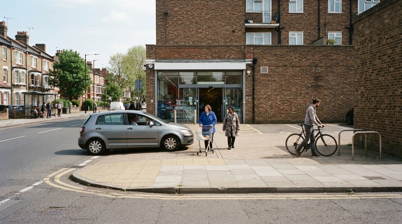
    Pedestrian movement matters at a supermarket because customers, staff and nearby residents share routes around the site. Newham’s population increased by 14% between the 2011 and 2021 censuses, according to the Office for National Statistics. That change makes local context important when considering who may walk to a store and where their journeys begin. The assessment should map likely walking routes, footways and crossings, then identify barriers between the site and nearby homes, bus stops or rail stations.

    On-site and off-site movement both matter. A useful review follows the customer journey from the surrounding street network to the entrance, including vehicle crossings, continuous footways and pedestrian routes through the site. It should consider accessibility for people with different mobility needs and whether servicing movements could conflict with walking routes. Survey observations can help identify busy periods, existing crossing activity and gaps in pedestrian infrastructure.

    Parking, cycle parking and servicing should be assessed against applicable local planning policy and the supermarket’s site-specific demand. The assessment should explain the proposed provision and how servicing can operate without obstructing pedestrian routes.

    Traffic generation and trip rates depend on the proposal’s characteristics and available travel evidence, not on one universal figure for supermarkets. The assessment should explain its assumptions and how estimated vehicle movements relate to the site and surrounding network.

    National planning guidance provides a wider context for considering sustainable access and transport effects. For an application in Newham, the practical task is to relate that context to local conditions: nearby routes, existing pedestrian infrastructure and the development’s expected activity. A clear report describes its evidence, identifies effects and sets out proportionate measures, helping planning officers understand how the proposal addresses movement beyond the site boundary.

    Recent Newham planning applications show the range of development contexts consultants may encounter. A 400 sqm floating vessel office project in Royal Docks was decided in July 2026, while a two-court padel tennis project was decided in June 2026. These examples are not supermarket trip-rate comparators. They illustrate why each application needs evidence suited to its use, access arrangements and likely travel patterns.

    Planning support should make pedestrian evidence easy to follow. A structured assessment can present:

    • Existing pedestrian routes, crossings and footway conditions.
    • Likely walking connections between the store, local streets and public transport.
    • Potential conflicts involving vehicle access, deliveries and people walking.
    • Practical mitigation linked to the issues identified in the assessment.

    This approach connects planning evidence to the actual site layout. For a supermarket proposal, the key is a clear explanation of existing conditions, how the development may change movement, and which measures respond to those effects.

    London Plan transport capacity policy

    For supermarkets in Newham and Greater London, the key question is whether a proposal is likely to have significant transport implications. The London Plan policy considered here does not set a supermarket-specific numerical trigger, so the assessment should focus on the proposal’s likely effects.

    Policy 6.3 is the London Plan policy cited for assessing development effects on transport capacity. Its practical purpose is to connect a proposed development with the ability of surrounding transport networks to accommodate the journeys it generates. A supermarket assessment therefore needs to examine more than the number of vehicle trips. It should consider access by all transport modes and how demand may affect the local network.

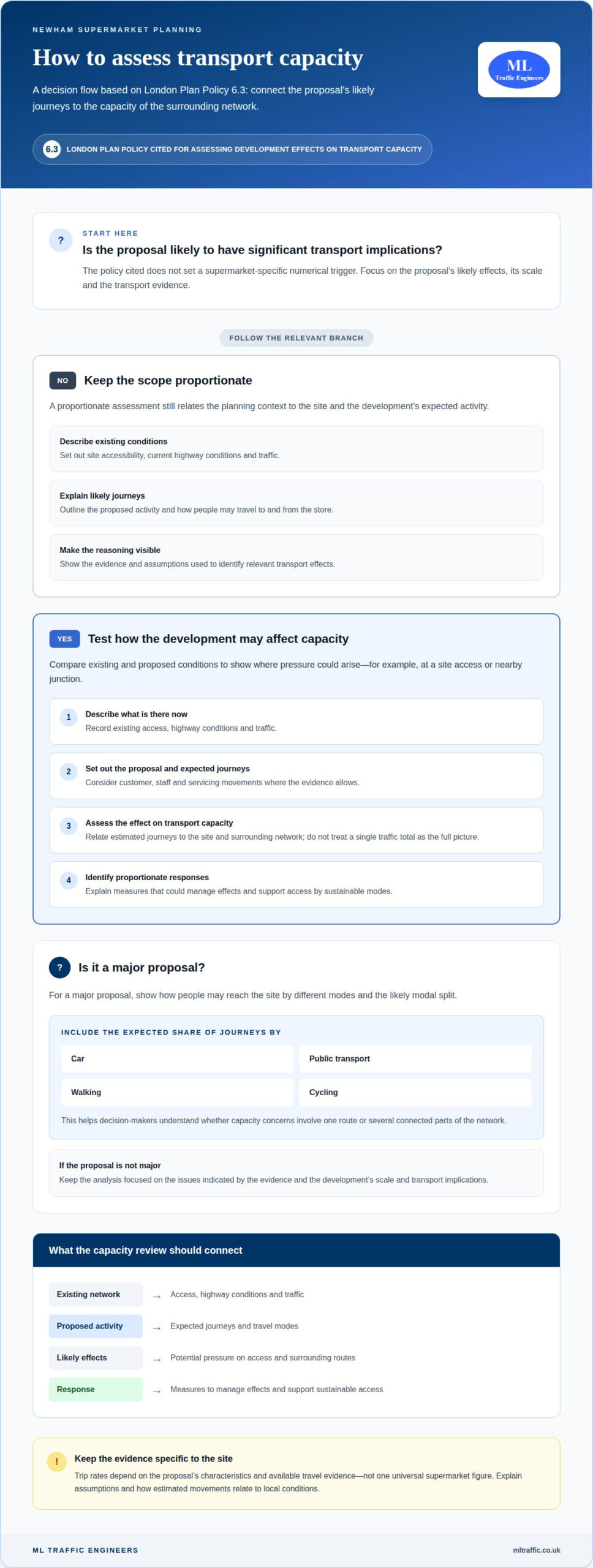
    A clear capacity review starts by describing existing conditions, including site accessibility, current highway conditions and traffic. It then sets out the proposed activity and likely journeys to and from the store. Comparing existing and proposed conditions helps show where pressure could arise, such as at a site access or nearby junction. The evidence should make assumptions visible and relate them to the development being assessed.

    For a major proposal, the assessment should show how people may reach the site by different modes and the likely modal split. This means considering the expected share of journeys by car, public transport, walking and cycling. The resulting picture helps decision-makers understand whether capacity concerns involve one route or several connected parts of the network.

    Transport capacity analysis can be organised around these steps:

    • Describe existing access, highway conditions and traffic.
    • Set out the proposed development and expected journey patterns.
    • Assess how those journeys may affect transport capacity.
    • Explain measures that could manage effects and support access by sustainable modes.

    Transport capacity also depends on how different journeys interact. A supermarket may attract customer trips while generating staff and servicing movements. Where the evidence allows, the assessment should distinguish these activity types and explain their combined implications for access and the surrounding network. This avoids treating a single traffic total as a complete account of transport effects.

    The appropriate scope depends on the development’s scale and the extent of its transport implications. A proportionate assessment focuses on issues identified by the evidence rather than applying identical analysis to every proposal. Where capacity concerns arise, the report should connect each effect to a relevant mitigation measure and explain how that measure supports the development’s access strategy.

    For a structured overview of the assessment process, the London transport assessment guide explains how evidence supports planning applications.

    Mitigating transport impacts

    Mitigation should respond directly to effects identified in the assessment. For a supermarket, this means linking each concern, such as queues near an access or conflict between delivery vehicles and pedestrians, to a proportionate measure. The report should explain the issue, the proposed response and how that response supports safe, workable access.

    Start by reviewing movement patterns around the site. An assessment can compare existing highway conditions and traffic with journeys expected from the development. If analysis identifies pressure at a junction, ARCADY and PICADY are examples of software used to assess development impacts at junctions. Findings can pinpoint where a change may be needed, rather than relying on general claims about network capacity.

    Measures should address the relevant mode and location. If a walking route to the store has a gap or difficult crossing, the assessment can identify improvements to pedestrian access. If public transport connections are weak, it can consider measures to make those journeys more convenient. The report should link each measure to the access issue it is intended to address.

    Parking is also part of mitigation. A scheme can consider how access by public transport, walking and cycling may reduce the need for associated parking. This does not remove the need to assess parking demand; it clarifies the relationship between travel choices and parking provision. The assessment should explain how proposed access measures support the development’s parking approach.

    Servicing needs its own practical review. The assessment should consider how delivery vehicles enter, move through and leave the site, and whether those movements overlap with customer or pedestrian routes. If it identifies a conflict, the report can describe a revised access arrangement or operational approach as a possible response. Any measure should relate to the site layout and the impact identified.

    A clear mitigation schedule can organise the findings:

    • Impact: identify the affected route, junction or transport mode.
    • Evidence: state which survey or analysis shows the issue.
    • Response: describe the measure proposed for that specific impact.
    • Outcome: explain how the measure supports access or reduces transport effects.

    This structure helps planning officers trace the reasoning from evidence to response. It also makes gaps easier to identify, such as a proposed walking improvement that does not connect to a useful route.

    For a supermarket proposal, effective mitigation considers the combined effects of customer, staff and servicing journeys. The final assessment should distinguish these movements where the evidence allows, explain how proposed measures relate to them, and show how access improvements fit the site. This provides a practical basis for understanding and managing the development’s transport impacts.
    Transport assessment for a supermarket in Newham

    Public transport, walking and cycling access

    For a Newham supermarket, access analysis should map how customers, staff and visitors can reach the site without relying solely on cars. It should identify nearby bus stops, rail, Underground or DLR stations, walking routes and cycle connections. The Greenway at Manor Road recorded 2,000 cyclists, a 32% increase from 2019. Romford Road recorded 1,500, a 34% increase since 2019. Leytonstone Road recorded 1,400, a 28% increase since 2019. These counts help describe local cycling activity, but the assessment must relate them to the proposed site.

    Walking conditions matter along the full journey, not only at the site boundary. In Newham, 49.1% of survey respondents cited poor-quality pavements or footpaths as a barrier to walking, while 48.0% felt vulnerable on some walking routes. An assessment should examine footway continuity, crossings, accessibility and links to local destinations. For example, a route may exist on a map but still be difficult to use if crossings or pavement conditions create barriers.

    Cycling access needs the same route-based review. In Newham, 54.1% of surveyed respondents identified a lack of safe or segregated cycling routes. A further 39.6% said air pollution and traffic noise made cycling unpleasant. The assessment should trace connections between the site and surrounding cycle routes, then identify interruptions or conflicts. It should also consider how cycle parking and the site entrance fit into the customer’s arrival route.

    Public transport evidence should consider practical access, not simply identify nearby services. In Newham, 34.3% of surveyed respondents said bus journey times were too slow, and 31.4% said they were unreliable. A site assessment can record nearby stops and stations, walking connections, and the travel options available to staff and customers. It should explain how those connections influence the expected pattern of journeys to and from the supermarket.

    For a major proposal, the assessment should describe access by all modes and the likely modal split, linking the site’s location with expected travel behaviour. A clear analysis can distinguish customer journeys from staff travel, then explain the evidence and assumptions behind each. For example, a strong public transport connection may support a different travel pattern from a site reached mainly through local streets.

    A practical access review can follow these steps:

    • Map existing walking, cycling and public transport connections.
    • Assess route quality, accessibility and barriers between the site and those connections.
    • Estimate how people may travel, explaining the basis for the expected modal split.
    • Identify measures that address specific access gaps or conflicts.

    For a supermarket, this joined-up review shows whether travel options work as complete journeys. A nearby bus stop alone does not demonstrate convenient access if the approach route is difficult. Similarly, cycle activity nearby does not prove that a continuous route reaches the entrance. Linking route evidence, expected journeys and proposed access measures gives planning officers a clearer view of how the site connects with Newham’s transport network.

    Transport consultants serving Newham

    A directory lists 31 companies with recent transport assessment work in and around Newham. That gives supermarket applicants a broad local choice, but the useful distinction is each consultant’s ability to match evidence to the site. A supermarket assessment should connect observed conditions, forecast journeys and planning implications in one clear report.

    Ask what evidence the assessment will use and how it will address the planning questions. For a supermarket, relevant data may include traffic counts on nearby roads, turning movements at affected junctions, pedestrian activity, parking conditions and site accessibility. The scope depends on the proposal and its likely transport effects. The report should explain where the data comes from, what it represents and how it informs the conclusions.

    Traffic and parking surveys can establish existing conditions for comparison with the proposed development. Their locations and timing should reflect the roads, junctions and parking areas relevant to the site. The analysis can then consider expected customer, staff and servicing journeys alongside recorded conditions. Where junction effects need closer examination, ARCADY and PICADY are examples of software used to assess development impacts.

    Recent application work offers context, but project type matters. Newham examples include a 400 sqm floating vessel office project in Royal Docks, decided in July 2026, and a two-court padel tennis project, decided in June 2026. Neither is a supermarket comparator. A consultant should explain how the proposed supermarket’s use, access and travel patterns shape its assessment, rather than treating unrelated applications as direct evidence.

    For planning application support, look for a coherent sequence in the technical work: define the site and proposal, review existing conditions, assess likely transport effects, then set out proportionate measures. A strong report makes its assumptions understandable and links each conclusion to supporting evidence. This helps planning officers assess the application without having to infer how the analysis fits together.

    Use these points to assess whether the proposed scope fits the supermarket:

    • Survey coverage: identify which roads, junctions, pedestrian routes and parking areas the evidence covers.
    • Travel analysis: explain how customer, staff and servicing journeys inform forecasts.
    • Local relevance: connect Newham site conditions with the assessment’s conclusions.
    • Planning clarity: link evidence, identified impacts and proposed mitigation in the report.

    The key takeaway is to choose a consultant whose analysis is specific to the site and transparent about its evidence. Discuss transport assessment support for your Newham proposal when you’re ready to progress the planning evidence.

    ML Traffic Engineers UK: Transport Assessments

    ML Traffic Engineers UK prepares Transport Assessments to support planning applications for supermarket developments. For a transport assessment for a supermarket in Newham, the work can examine site access, expected travel patterns and effects on the surrounding network, with scope suited to the proposal.

    Turn to ML Traffic Engineers UK when you need transport evidence for an application or clearer analysis of a site-specific issue. A Transport Statement may suit proposals with more limited transport implications. Parking Surveys can provide evidence about existing parking conditions, while Swept Path Analysis can assess vehicle movements through the proposed layout.

    These services connect planning questions with relevant transport analysis and documentation. Contact ML Traffic Engineers UK to discuss your Newham supermarket proposal.

    Prepare the next planning step

    Before a supermarket application progresses, align the transport evidence with the current proposal design. A clear site layout, access arrangement and description of the intended use help define the assessment’s scope. This gives the planning team a practical starting point for considering the transport questions raised by the development.

    A transport assessment for a supermarket in Newham should support decisions, not simply add technical detail. Its value lies in connecting the proposal’s characteristics with evidence that planning officers can follow. If the design changes, keeping the transport analysis aligned with those changes maintains a clear relationship between the application and its supporting material.

    ML Traffic Engineers UK can discuss the transport documentation and analysis relevant to your proposal. Contact ML Traffic Engineers UK to discuss your supermarket planning application and take a clear next step with your transport evidence.

    With the right project information, you can move forward with a more focused planning process.

    Frequently Asked Questions

    What is a transport assessment?

    A transport assessment evaluates how a proposed development may affect transport and sets out ways to manage those effects. It considers the journeys a development could generate, the surrounding network and access by different travel modes. For example, an assessment for a new store can examine whether its access arrangements suit expected customer and delivery movements. It gives planning decision-makers evidence about transport consequences and proposed measures to address them.

    What is a transport assessment for a supermarket development in Newham?

    A transport assessment for a supermarket in Newham is a project-specific review of the store’s access and likely transport effects. It can distinguish customer, employee and delivery journeys, then relate those movements to the site layout and local network. For example, a proposed entrance beside a busy junction may require closer analysis of turning movements. The report explains its evidence and assumptions so the planning case reflects the supermarket’s intended use.

    What are Newham Council’s transport assessment and travel plan requirements?

    The scope should reflect the proposal’s scale and likely transport implications. For a supermarket, relevant considerations include site access, expected journeys and how the development connects with local travel options. A Green Travel Plan can set out measures supporting public transport, walking and cycling, alongside steps to manage travel-related effects. Application documents should explain how each measure relates to the proposal, rather than relying on generic commitments.

    Which TfL and London Plan policies govern supermarket transport assessments?

    London Plan Policy 6.3 is cited for assessing development effects on transport capacity. The London Plan also indicates that applications for developments likely to have significant transport implications should include a transport assessment. For a supermarket, the assessment should show how the proposal’s travel demand relates to transport capacity and access. These policy considerations help frame the evidence; the analysis should connect them to the specific site and proposed development.

    How should a supermarket transport assessment assess walking, cycling and public transport access?

    The assessment should examine whether people can make a practical journey from local streets and transport stops to the store. For example, it can trace a route from a nearby bus stop, identify crossings or access barriers, and consider whether the site entrance connects appropriately with that route. It should also consider cycle connections and access for people with mobility needs, then relate these findings to expected travel choices.

    What are the main transport risks and mitigation measures for a supermarket planning application in Newham?

    Potential risks include pressure at nearby junctions, queues at site access, and conflicts between delivery movements and people walking. Mitigation should respond to the specific issue identified. If vehicle turning creates a concern, for example, the assessment can examine access arrangements and vehicle movements. If a walking route has a gap, it can identify a relevant connection improvement. The report should link each proposed measure to evidence and its intended transport effect.

    Michael Lee

    Article by

    Michael Lee

    Transport planner with over 35 years' experience.

    Disclaimer

    The content on mltraffic.co.uk, including all technical articles, guides, and resources, is provided for general informational and educational purposes only. It is not intended to constitute professional advice in traffic engineering, transportation planning, development approvals, or any other technical or legal field.
    While ML Traffic Engineers makes every reasonable effort to ensure the accuracy, completeness, and timeliness of the information published, we do not provide any warranties or representations (express or implied) regarding its reliability, suitability, or availability for any particular purpose. Any reliance you place on the content is strictly at your own risk.
    In no event shall ML Traffic Engineers, its directors, employees, authors, or affiliates be liable for any direct, indirect, incidental, special, consequential, or punitive damages (including, without limitation, loss of profits, data, or business opportunities) arising out of or in connection with the use of, or inability to use, any information provided on this website.
    The articles and guides on this site are not a substitute for engaging a qualified, professional traffic engineer to assess your specific project requirements. For tailored advice, compliance assessments, or traffic engineering services, please contact a competent professional.
    This disclaimer may be updated from time to time without notice. By accessing or using this website, you agree to be bound by the most current version of this disclaimer.
  • How to prepare a transport assessment for planning permission

    How to prepare a transport assessment for planning permission

    A transport assessment for a multi-storey park and ride scheme explains how the proposal could affect travel, traffic and access, and what measures could manage those effects. It gives the planning authority evidence to consider alongside the application, including how people will reach the site by car, public transport, walking and cycling.

    A large parking structure can affect more than the roads at its entrance. The assessment should consider the journeys the scheme may generate, its connections to the surrounding network and whether access works safely and practically for different users. Clear evidence shows how the development fits its transport context and where changes may be needed.

    This guide explains why a Transport Assessment may be needed, how to define its scope and what evidence to include. It also covers how to assess transport impacts, develop proportionate mitigation and demonstrate sustainable access. The aim is to make the findings clear, relevant to the proposal and useful in the planning process.

    Key Takeaways

    • Set the assessment’s scope around the scheme’s likely travel patterns and effects on the surrounding transport network.
    • Use clear, relevant evidence and visual material to explain existing conditions, proposed access and expected changes.
    • Assess how the development could affect transport capacity, congestion and highway safety, then connect findings to planning considerations.
    • Make mitigation proportionate to the impacts, considering measures such as improved public transport, pedestrian access and cycle provision.
    • Review access by walking, cycling and public transport alongside car access, and select the appropriate transport report for the proposal’s scale and effects.

    Assessment format and supporting evidence

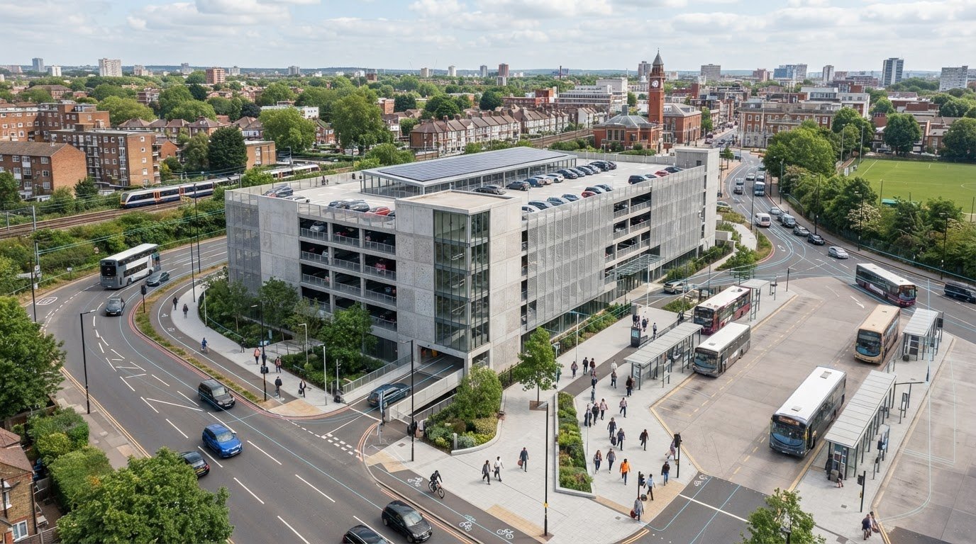
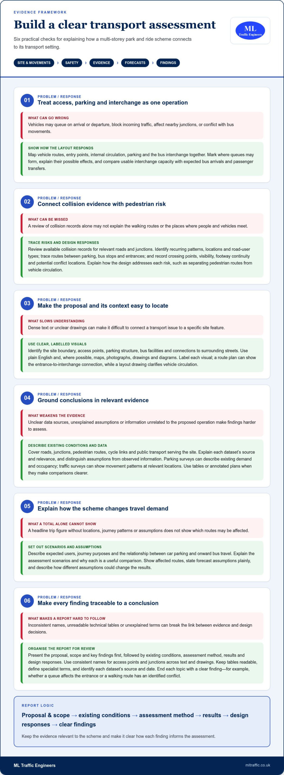
    1. Map access, parking and interchange as one connected operation. Show vehicle routes, entry points, internal circulation, the parking layout and the bus interchange on a clear plan. Assess how arriving vehicles reach spaces and leave without blocking incoming traffic. Mark where queues may form and explain how they could affect site access or nearby junctions. Compare the interchange’s usable capacity with expected bus arrivals and passenger transfers. This shows whether the layout can manage these movements effectively.
    2. Assess road safety, collision data and pedestrian risks together. Review available collision records for relevant roads and junctions, then identify recurring patterns, locations and road-user types. Trace routes between parking, bus stops and site entrances. Record crossing points, visibility, footway continuity and locations where vehicles and pedestrians may conflict. Explain how the design responds to each identified risk, for example by separating pedestrian routes from vehicle circulation.
    3. Set out the proposal and its transport context clearly. Identify the site boundary, access points, parking structure, bus facilities and connections to surrounding streets. Use plain English and, where possible, maps, photographs, drawings and diagrams instead of dense text. Label each visual so readers can locate the feature discussed. A route plan, for example, can show the connection from the site entrance to the bus interchange, while a layout drawing clarifies vehicle circulation.
    4. Build the evidence base around existing conditions and the proposed operation. Describe the roads, junctions, pedestrian routes, cycle links and public transport serving the site. Explain the source and relevance of each dataset, and distinguish assumptions from observed information. A parking survey can describe existing demand and occupancy; traffic surveys can show movement patterns at relevant locations. Present findings in tables or annotated plans where this makes comparisons easier to follow.
    5. Explain how the scheme could change travel behaviour and network demand. Describe the expected users, journey purposes and relationship between car parking and onward bus travel. Set out the assessment scenarios and explain why each provides a useful comparison. Show the routes affected by the proposal rather than reporting totals without location. State forecast assumptions plainly and explain how different assumptions could change the results.
    6. Organise the report so planning officers can trace evidence through to conclusions. Begin with the proposal, scope and key findings, then present existing conditions, assessment method, results and design responses. Use consistent names for access points and junctions across text and drawings. Keep technical tables readable, define specialist terms, and identify the source and date of each dataset. End each topic with a clear finding, such as whether a queue affects the site entrance or a walking route has an identified conflict.

    Transport impacts and planning permission

    Assess how the scheme changes travel conditions, then connect each finding to planning policy and design decisions. In England, frame the assessment using national policy and the relevant local development plan.

    1. Identify Relevant Planning Guidance

      Start by identifying national planning policy and the local development plan policies that apply to the site. According to the UK Government, significant adverse effects on transport capacity, congestion or highway safety should be mitigated to an acceptable degree using a vision-led approach. Apply that principle to the park and ride proposal: explain its transport objectives, the journeys it supports and how the design responds to impacts. Avoid relying on a policy reference without showing how it affects the assessment.

    2. Assess Construction Traffic and Site Access

      Separate temporary construction movements from traffic generated by the completed scheme. Describe construction vehicle routes, site access, delivery activity and any interaction with nearby junctions or pedestrian routes. Explain how construction access will work alongside the permanent entrance rather than treating the arrangements as interchangeable. For example, identify where construction vehicles would enter and whether turning movements could affect through traffic. State the assessment’s scope and assumptions clearly, and relate each identified effect to a practical design or management response.

    3. Calculate Traffic Generation and Trip Rates

      Estimate operational traffic from the scheme’s expected use, not simply its total parking supply. Set out demand assumptions, arrival and departure patterns, likely peak periods and the trips that continue by bus. Explain how trip rates are derived and why the evidence represents this park and ride function. Distinguish new trips from journeys that would use the network anyway. Test how changes in occupancy, user demand or arrival patterns could affect the forecast, without presenting assumptions as observed facts.

    4. Forecast Travel Demand and Mode Share

      Treat mode share, vehicle occupancy and peak-hour demand as connected inputs. Explain how people reach the car park, how many travel together and when arrivals are concentrated around bus departures. Use these forecasts to test site access and affected junctions. Junction capacity modelling should compare existing conditions with the proposal, including traffic flows, queues and delays. Identify where queues could reach the site entrance or disrupt the bus interchange. Relate each model result to the scheme’s design and state clearly which assumptions drive the outcome.

    Transport mitigation and planning obligations

    Match each mitigation measure to an identified transport effect. Record its purpose, how it would be delivered and how it relates to the park and ride scheme.

    1. Link each measure to a specific impact identified in the assessment. The UK Government says significant adverse effects on transport capacity, congestion or highway safety should be mitigated to an acceptable degree using a vision-led approach. If forecast queues affect a nearby junction, for example, explain how a proposed change addresses that effect. Avoid presenting an unrelated improvement as mitigation. A clear link between impact and response helps decision-makers understand what the measure is intended to achieve.
    2. Choose measures that respond to the evidence and support sustainable access. Options could include adding cycle parking, reducing or removing car parking, or providing pedestrian crossings to local bus stops. For a park and ride scheme, link each option to a finding: a crossing may address an identified pedestrian barrier, while revised parking provision may respond to the assessment’s travel-demand conclusions. Explain where the measure would be located and which movement it supports, rather than listing interventions without context.
    3. Assess whether local public transport needs a proportionate contribution. Transport mitigation may include financial contributions to increase the frequency and capacity of local public transport services. Describe the service pressure identified by the assessment, the improvement the contribution would support and its connection to the development’s travel effects. For example, explain how increased bus capacity relates to forecast passenger demand from the parking facility. Keep the purpose clear so the measure can be considered alongside physical site changes.
    4. Apply the planning obligation tests before proposing a contribution. In England, Regulation 122 and Paragraph 204 of the National Planning Policy Framework set out tests for requiring planning obligations for development proposals. Explain how a proposed obligation relates to the park and ride scheme and the transport effect it addresses. Avoid treating a contribution as a general funding request: identify the relevant transport need and show how the proposed measure responds to it.
    5. Check how infrastructure contributions would be pooled. The Community Infrastructure Levy Regulations restrict pooling Section 106 contributions to no more than five obligations towards new infrastructure. Identify whether the proposed transport measure involves a Section 106 contribution and consider the pooling limit when setting out the funding approach. Then distinguish that financial obligation from on-site design measures, such as cycle parking or pedestrian crossings. This makes the mitigation schedule easier to interpret and ties each action to its delivery route.

    How to prepare a transport assessment for planning permission

    Walking, cycling and public transport

    1. Map how people can reach the Manchester site without a car. Show walking routes from nearby streets, bus stops and surrounding destinations to the park and ride entrance. Identify barriers such as missing footways, difficult crossings or indirect connections. Assess whether each route is continuous, legible and convenient for people heading to the interchange. The plan should show where routes meet site access, rather than simply drawing a line towards the boundary.
    2. Inspect pedestrian movement inside the site as well as outside it. Trace the route from parking spaces to the bus interchange, ticketing area and passenger waiting points. Identify where pedestrians cross vehicle circulation lanes and show how the layout manages those conflict points. For example, an entrance walkway crossing a car park aisle needs clear visibility and a direct connection to the interchange. Explain any route changes that could reduce unnecessary walking or vehicle conflict.
    3. Assess cycling access from approach routes through to secure, convenient parking. Map how cyclists enter the site and reach cycle parking without unnecessary crossings of bus manoeuvring areas. Explain how the parking provision relates to the scheme’s intended use and show its position on the site layout. One cycle parking stand provides two cycle parking spaces. Keep the proposed number of stands and spaces clear when presenting the provision.
    4. Describe the public transport connections that make the park and ride function work. Identify the bus routes serving the interchange, their access paths and the relationship between passenger waiting areas and boarding points. Consider how buses enter, circulate, stop and leave without obstructing vehicle access or pedestrian routes. Show the walking connection between the parking facility and each relevant stop. Where passengers must cross an internal road, identify the crossing location and explain how the design addresses that movement.
    5. Test whether access works for different users and operating conditions. Review footway continuity, crossing visibility, lighting shown in the design and wayfinding between parking and buses. Consider passengers carrying luggage, using mobility aids or travelling with children. Identify any route that relies on crossing a bus path or passing through vehicle queues. Mark the design response on plans so the assessment connects each access issue to a specific location.
    6. Present the findings as a connected access strategy. Use a route plan to show links from Manchester streets, cycle approaches and bus stops to the interchange. Summarise gaps and constraints, then show how the site layout responds. Make clear which improvements support walking, cycling or public transport, and how each relates to the park and ride journey. This helps planning officers assess whether sustainable access is part of the site’s operation rather than a separate feature.

    When a Transport Assessment is required

    Decide the assessment’s scope early, considering the scheme’s scale, location and likely travel effects. For a Manchester park and ride proposal, explain why the chosen level of transport evidence suits the development.

    1. Review the proposal’s characteristics and identify where travel effects may arise. Consider parking capacity, access arrangements, bus interchange activity and connections to nearby streets. A multi-storey facility may concentrate vehicle arrivals at particular access points while passengers transfer between cars and buses. Record these features before deciding which transport questions need detailed analysis. The building’s size alone does not capture its transport effects.
    2. Discuss the scope with the local planning authority through the application’s pre-application process. Set out the site, proposed use, access strategy and anticipated transport issues. Ask which network locations and travel modes the assessment should address. A junction serving the site entrance, for example, may need attention alongside pedestrian routes to the interchange. Record the agreed scope and assumptions so the final submission addresses the same issues.
    3. Select the report format to match the likely effects. A Transport Statement is a shorter, simpler alternative to a Transport Assessment for developments with limited transport impacts. Consider whether the park and ride proposal’s access, traffic generation, interchange operation and sustainable connections need broader analysis. Explain the choice in the planning material, linking it to the development’s characteristics and expected effects. Do not choose a shorter report simply for convenience.
    4. Check what supporting evidence the application needs alongside the main assessment. The scope may need to address traffic generation, junction operation, parking demand, pedestrian access and public transport connections. Identify the evidence for each issue, then show how the results inform the design. If the scheme’s access could affect a nearby junction, for example, explain how the traffic evidence tests that effect. Keep temporary construction movements distinct from the completed scheme’s operation.
    5. Use policy and the assessment scope to explain the transport context for the planning decision. In England, the UK Government states that significant adverse effects on transport capacity, congestion or highway safety should be mitigated to an acceptable degree using a vision-led approach. Show how the assessment identifies relevant effects and connects them to design responses. This helps the planning authority understand the evidence behind the proposal rather than relying on unsupported conclusions.

    Once the scope and evidence needs are clear, take the next step with your planning evidence.

    ML Traffic Engineers UK: Transport Statements

    ML Traffic Engineers UK prepares Transport Assessments and Transport Statements to support planning applications. When developing a transport assessment for multi storey park and ride scheme proposals, comprehensive evidence can be brought together regarding traffic effects, access, parking demand and connections to public transport. A Transport Statement may suit a proposal with limited transport impacts, while a broader assessment addresses more complex effects.

    Parking Surveys can help establish existing parking conditions, while Swept Path Analysis can assess vehicle movement through the proposed layout. ML Traffic Engineers UK prepares Transport Assessments and Transport Statements to support planning applications. Its traffic data and technical analysis can help define assessment scope, interpret transport evidence and present project-specific findings.

    To discuss your transport planning requirements, contact ML Traffic Engineers UK or visit mltraffic.co.uk.

    Take the next step towards a clear planning submission

    Use the assessment to guide the decisions that follow, not simply to complete an application requirement. A transport assessment for a multi-storey park and ride scheme should connect the proposal’s transport evidence with its design and planning case. Keep the reasoning clear so decision-makers can understand how the scheme responds to its setting and identified effects.

    Before submission, make sure the report and application drawings describe the same proposal. Check that access arrangements, parking layout and sustainable travel connections are consistent across the documents. If design changes affect these details, update the supporting evidence too. This final review helps prevent gaps between the assessment’s conclusions and the plans submitted for consideration.

    ML Traffic Engineers UK can help you prepare transport planning documentation for a development proposal. Take the next step by contacting ML Traffic Engineers UK to discuss your project. A clear, coordinated submission gives your planning application a stronger foundation, so you can move forward with confidence.

    Frequently Asked Questions

    Why do a TA?

    A Transport Assessment gives the planning authority a structured basis for considering a proposal’s transport effects. For a park and ride scheme, it can show how the site may affect surrounding roads and how passengers connect with onward journeys. It also helps the project team identify design changes while plans are still being developed, supporting both the planning decision and practical development of the scheme.

    What transport assessment is required for a multi-storey park and ride scheme in the UK?

    The report required depends on the development’s scale, location and likely transport effects. A transport assessment for a multi-storey park and ride scheme should address how the facility operates as a whole, including parking arrivals, onward bus travel and access to surrounding networks. The appropriate scope should reflect the proposal and relevant planning context. A Transport Statement is a shorter alternative for developments with limited transport impacts.

    What public transport, walking and cycling connections should a park and ride assessment cover?

    Show how people travel between the site, nearby streets, bus stops and the interchange. Trace a walking route from the site entrance to a bus boarding point, for example, and note where it crosses vehicle circulation. Map cycle approaches and explain how cyclists reach cycle parking. Describe the bus connections serving the interchange and how passengers move between parking, waiting areas and services without unclear or indirect routes.

    What mitigation measures and travel plan targets are commonly required for UK park and ride schemes?

    Set travel plan targets around the scheme’s intended outcomes, such as encouraging bus use or reducing single-occupancy car journeys. Define how progress will be measured, who will review it and what action would follow if results fall short. Mitigation should address identified effects: a pedestrian access issue may call for a crossing improvement, while pressure on bus capacity may support service enhancements. Link each measure to its purpose.

    What local authority transport assessment requirements apply to the proposed park and ride site?

    The relevant local planning authority’s requirements depend on the site, proposal and affected transport network. Set the assessment scope around the access roads, junctions, bus connections and walking or cycling routes relevant to the location. For a Manchester site, explain how local conditions shape the evidence and analysis. Record the authority’s requested topics and ensure the submitted drawings and report assess the same scheme.

    Michael Lee

    Article by

    Michael Lee

    Transport planner with over 35 years' experience.

    Disclaimer

    The content on mltraffic.co.uk, including all technical articles, guides, and resources, is provided for general informational and educational purposes only. It is not intended to constitute professional advice in traffic engineering, transportation planning, development approvals, or any other technical or legal field.
    While ML Traffic Engineers makes every reasonable effort to ensure the accuracy, completeness, and timeliness of the information published, we do not provide any warranties or representations (express or implied) regarding its reliability, suitability, or availability for any particular purpose. Any reliance you place on the content is strictly at your own risk.
    In no event shall ML Traffic Engineers, its directors, employees, authors, or affiliates be liable for any direct, indirect, incidental, special, consequential, or punitive damages (including, without limitation, loss of profits, data, or business opportunities) arising out of or in connection with the use of, or inability to use, any information provided on this website.
    The articles and guides on this site are not a substitute for engaging a qualified, professional traffic engineer to assess your specific project requirements. For tailored advice, compliance assessments, or traffic engineering services, please contact a competent professional.
    This disclaimer may be updated from time to time without notice. By accessing or using this website, you agree to be bound by the most current version of this disclaimer.