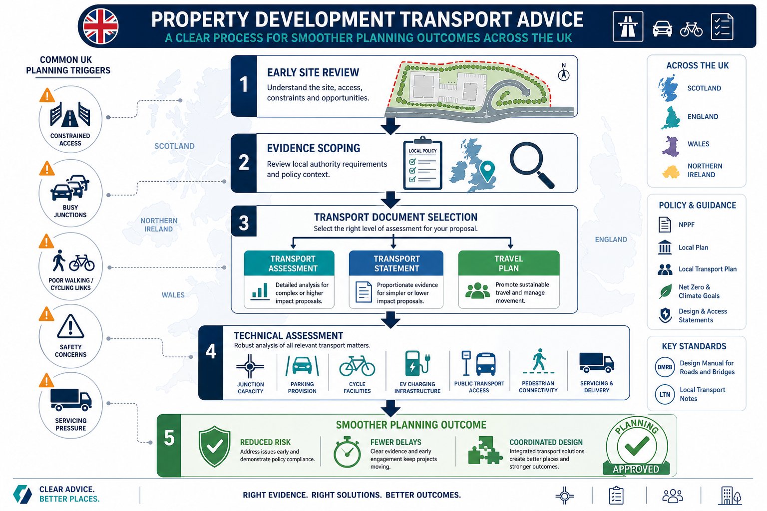
Planning risk rarely starts at committee. More often, it starts much earlier, when a site layout is fixed before anyone has properly tested access, trip impact, parking pressure, or whether the local authority will expect a Transport Assessment at all. That’s why property development transport advice matters so much in 2026.
Across the UK, planning officers and highway authorities are looking closely at how development affects not just road capacity, but sustainable travel, safety, servicing, EV provision, active travel links, and the wider place-making agenda. A scheme can look commercially strong on paper, yet still run into delay if transport evidence is weak, late, or out of step with local policy.
For architects, planners, lawyers, surveyors, developers and councils, the practical question isn’t simply whether a transport report is needed. It’s what level of evidence will be proportionate, what the risks are, and how early transport input should shape the scheme.
In this guide, we set out what developers need to know: when transport input is likely to be required, what consultants actually review, how assessments are prepared, and where applications often come unstuck. Drawing on the realities of UK planning practice, and the kind of concise, authority-aware reporting firms such as ML Traffic are known for, we’ll show how early, well-scoped transport advice can save time, redesign costs, and a lot of avoidable friction.
Why Transport Advice Matters Early In The Development Process
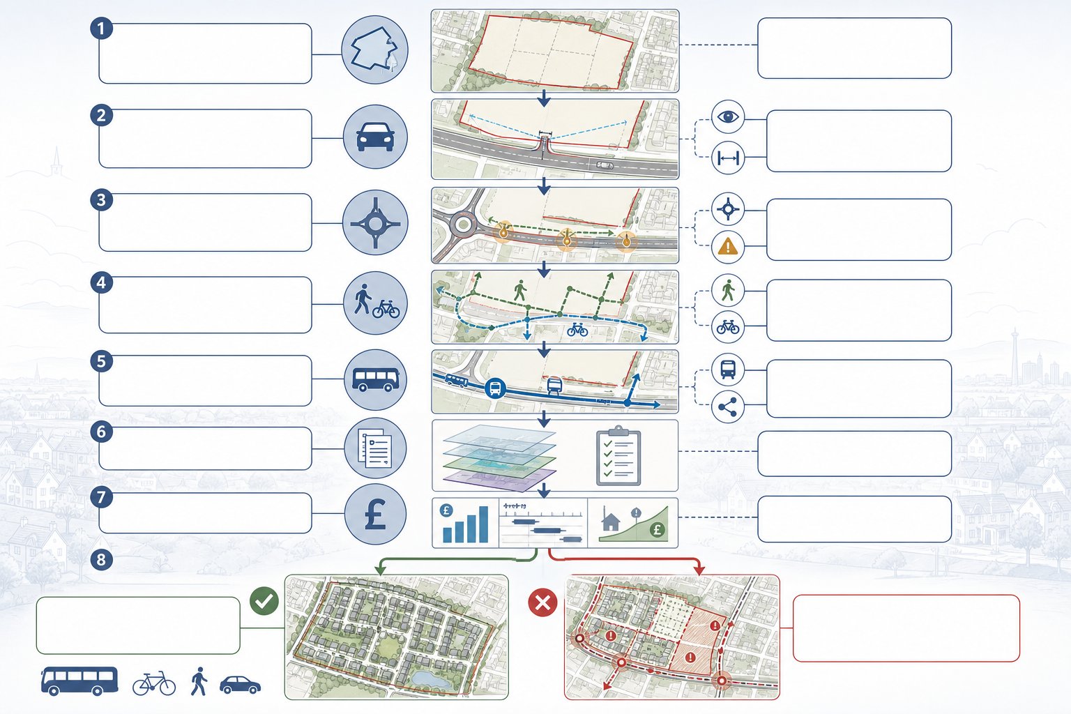
The biggest value of early transport input is that it influences decisions while they are still cheap to change. Once a red-line boundary is fixed, a preferred access point chosen, and unit numbers baked into the appraisal, transport problems become expensive problems.
In practice, early advice helps us test whether a site can realistically support the proposed scale and type of development. That includes obvious questions, can vehicles get in and out safely, is visibility acceptable, are nearby junctions already stressed, but also less obvious ones. Is the site genuinely accessible on foot? Are bus services frequent enough to support lower parking provision? Will the authority expect off-site improvements, a crossing upgrade, or cycle links? Those issues can affect viability just as much as build costs.
This is also where planning policy comes into sharp focus. National policy continues to emphasise sustainable transport and safe, suitable access, while local plans and supplementary guidance often set specific thresholds or expectations. If we assess those requirements early, we can shape the masterplan around them rather than scrambling to justify a poor fit later.
And there’s a commercial angle that experienced developers understand immediately: transport advice is a due diligence tool. Before land is acquired, it can reveal whether a site is likely to need junction mitigation, bus stop improvements, travel plan monitoring, parking restraint, or technical modelling. That knowledge feeds directly into land value, programme, and delivery strategy.
Put simply, early transport advice doesn’t just support planning. It helps determine whether the scheme is workable in the first place.
How Transport Evidence Supports Planning Applications
Good transport evidence gives decision-makers confidence. It shows that the likely effects of development have been assessed properly, that impacts can be managed, and that the scheme aligns with transport and land-use policy rather than cutting across it.
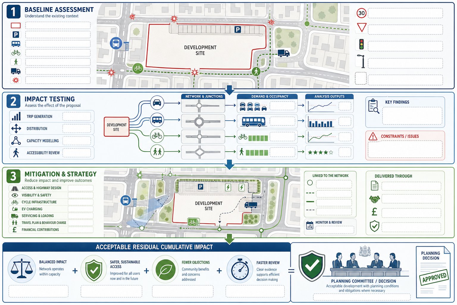
At application stage, transport documents usually serve three related purposes.
First, they explain existing conditions. That means the surrounding highway network, sustainable travel options, collision history, parking context, servicing environment, and any known constraints. Without that baseline, there is no credible way to judge impact.
Second, they quantify the effect of the development. Depending on scheme scale, that may involve trip generation, distribution and assignment, junction modelling, parking demand analysis, and review of walking, cycling and public transport accessibility. For some sites, the issue is highway capacity. For others, it is whether the location can support policy-compliant mode share assumptions.
Third, they set out mitigation and strategy. That could include access redesign, visibility improvements, local highway works, travel plan measures, cycle parking, EV charging, servicing controls, or contributions secured through planning obligations.
This matters because planning officers, highway officers and committee members are not simply asking, “Will traffic increase?” Of course it will, to some degree. The real question is whether the residual cumulative impacts are acceptable and whether the scheme delivers safe and sustainable access in policy terms.
Well-prepared evidence can also reduce ambiguity in consultation. Instead of prolonged back-and-forth over assumptions, the application presents a clear, proportionate, policy-led case from the outset. That tends to mean faster review, fewer technical objections, and a stronger platform for negotiation if mitigation is needed.
Transport Assessment, Transport Statement, And Travel Plan: What Is The Difference?
These documents are often mentioned together, but they do different jobs.
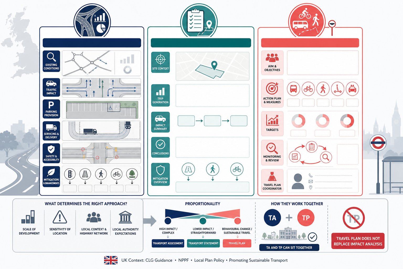
A Transport Assessment (TA) is the fuller, more analytical document. It is usually prepared for larger schemes, developments in sensitive locations, or proposals where transport effects are likely to be material. A TA will typically cover site accessibility, baseline conditions, trip generation, trip distribution, junction impact, parking, servicing, road safety, and mitigation. It is evidence-heavy and often supported by modelling or technical appendices.
A Transport Statement (TS) is a lighter-touch version for smaller or less impactful proposals. The principle is proportionality. A TS still needs to be robust, but it may not require the same level of survey data, modelling, or scenario testing as a full TA. For many modest residential or commercial schemes, a TS is the appropriate tool where impacts are limited and straightforward to explain.
A Travel Plan (TP) is different again. It is not primarily an impact assessment. It is a strategy document aimed at influencing travel behaviour. A Travel Plan sets out measures to encourage sustainable travel, such as cycle facilities, public transport information, car club provision, welcome packs, monitoring arrangements, targets, and coordinator responsibilities. On larger schemes, authorities often expect a TP alongside a TA rather than instead of one.
The mistake we sometimes see is assuming these documents are interchangeable. They aren’t. A Travel Plan cannot fill the gap where junction impact has not been assessed, and a Transport Statement is not enough if the local authority expects a full assessment because of scale, sensitivity, or policy thresholds.
The right question is not “Which document is easiest?” It’s “What level of evidence is proportionate and likely to satisfy the authority?” That’s the decision that matters.
When A Development Is Likely To Need A Transport Report
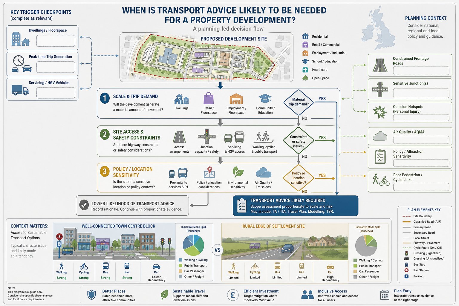
There is no single national trigger that covers every site in every authority, which is why local context matters so much. But in broad terms, a transport report becomes likely where a development would create material travel demand, raise access concerns, or sit within a policy-sensitive location.
Larger residential schemes are the obvious example, but they are far from the only one. Retail, logistics, education, healthcare, leisure, mixed-use and employment developments can all require formal transport evidence, especially where trip peaks coincide with existing congestion or where servicing demands are substantial.
We also see transport reports requested for relatively modest schemes if the site is constrained. A small development on a narrow frontage road, near a busy junction, or with poor pedestrian links may attract more scrutiny than a larger scheme in a highly accessible urban area. That can surprise applicants who focus only on unit numbers or floorspace.
Another trigger is strategic relevance. If access is proposed onto a classified road, near a junction of concern, or within an area where the highway authority has known capacity or safety issues, transport evidence is usually expected early and in some depth.
And then there is policy. Many local planning authorities publish validation requirements, local plan policies, parking standards, and transport guidance that effectively determine whether a TA, TS or Travel Plan will be needed. Ignoring those documents is one of the quickest ways to lose time.
Typical Triggers Considered By Local Planning Authorities
Local planning authorities tend to look at a mix of scale, impact, and sensitivity rather than one blunt threshold alone.
Common triggers include:
- number of dwellings or gross floorspace
- likely trip generation at peak times
- access onto a busy, constrained, or strategic route
- proximity to sensitive junctions, schools, town centres, or air quality issues
- poor availability of walking, cycling, or public transport options
- servicing intensity, especially for commercial uses
- collision history or known highway safety concerns nearby
Some authorities set indicative thresholds in local guidance, while others rely more heavily on professional judgement. Either way, the direction of travel is clear: if a proposal has a realistic prospect of affecting network performance, safety, or sustainable access, expect transport evidence to be required.
How Site Location And Existing Network Conditions Affect Requirements
Location can change everything. A town-centre infill site near rail, bus, shops and services may justify lower parking provision and a stronger emphasis on walking, cycling and mode shift. In those cases, the assessment may focus more on accessibility, parking management, and travel planning than on major junction capacity issues.
By contrast, edge-of-settlement or rural sites often face tougher questions. If residents or staff are likely to rely heavily on the private car, the authority may want stronger evidence on trip rates, assignment, visibility, road geometry, bus service viability, or off-site mitigation. Even where highway capacity is acceptable, weak sustainable transport credentials can become a policy issue.
Existing network conditions matter just as much. A site next to a junction already operating under pressure is more likely to trigger modelling. A site with a poor collision record nearby is more likely to require detailed safety review. And where footways are missing, crossing opportunities are weak, or cycling connections are severed by major roads, transport evidence has to grapple with those real-world constraints rather than gloss over them.
That’s why site-specific advice beats assumptions every time.
What A Transport Consultant Will Review Before Recommending A Strategy
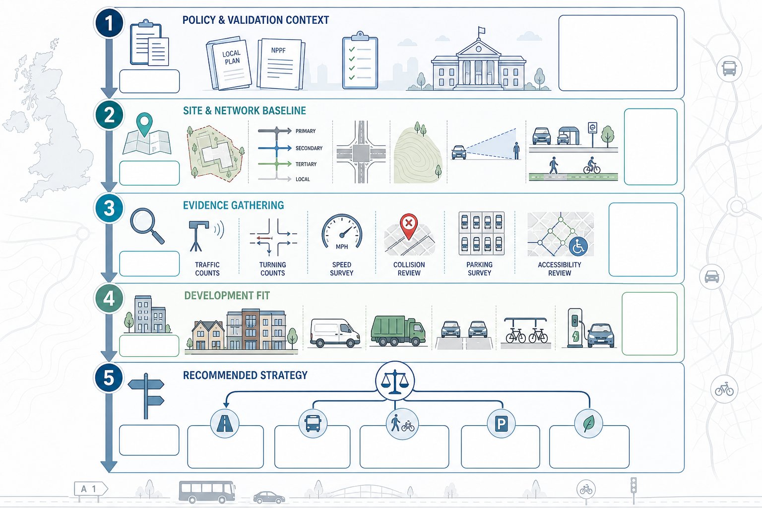
Before recommending whether a scheme needs a TA, TS, Travel Plan, technical note, or a package of supporting drawings, a transport consultant will usually work through several layers of review.
The first is policy and validation context. We need to know what the local planning authority and highway authority typically expect, what the local plan says about sustainable transport, parking, and accessibility, and whether supplementary guidance sets thresholds or methodology preferences.
The second is the site and network baseline. That means existing access arrangements, road hierarchy, speed environment, visibility, topography, nearby junctions, traffic conditions, parking stress, public transport services, walking and cycling routes, and local amenities. Desktop review is useful, but site visits are where awkward truths often show up, a steep route that looks walkable on plan but isn’t in practice, or a visibility issue hidden by street furniture and parked vehicles.
The third is evidence gathering. Depending on the scheme, that may include traffic counts, junction turning counts, queue surveys, speed surveys, collision data, parking beat surveys, or accessibility mapping. The aim is to establish what is actually happening, not what we assume is happening.
Then comes development fit. We review likely trip generation, servicing needs, refuse collection, parking demand, cycle parking, EV charging expectations, and whether the proposed layout can accommodate vehicles safely and efficiently.
Only after those strands are understood can we recommend a sensible strategy. Sometimes that means a full assessment. Sometimes it means a proportionate statement with focused technical appendices. The best consultants do not start with a template. They start with the planning problem the site actually presents.
Access, Parking, Servicing, And Highway Safety Considerations
These are the issues that often decide whether a scheme feels credible to a highway officer.
Access comes first. The authority will want to know whether the proposed access point is suitable in principle, whether visibility splays meet the relevant standard, whether gradients are acceptable, and whether vehicles can enter and leave without conflict or overrun. On tighter sites, the exact geometry matters enormously. A seemingly minor change in kerb line, gate position, or internal tracking can make the difference between an acceptable and unacceptable arrangement.
Parking is no longer just a matter of counting spaces. Authorities increasingly look at parking provision in the round: local standards, disabled bays, visitor provision, cycle parking quality, EV charging infrastructure, motorcycle spaces where relevant, and whether parking restraint is justified by accessibility. Over-provision can be as problematic as under-provision if it undermines sustainable transport policy or site quality.
Servicing and refuse are another frequent weak point. Delivery vehicles, refuse trucks, and emergency access all need to be considered early. Swept path analysis often reveals design conflicts that are not obvious on a general arrangement drawing. If a vehicle has to reverse excessively, mount footways, or block the carriageway, objections tend to follow.
Then there is highway safety. That includes collision record review, conflict points, pedestrian desire lines, crossing opportunities, school routes, and the interaction between cars, cyclists and service vehicles. Some schemes may also require a Road Safety Audit or response process, particularly where highway works are proposed.
These are technical matters, yes. But they are also practical ones. If the access looks awkward, the parking feels unrealistic, or servicing appears unresolved, confidence in the whole application drops very quickly.
How Trip Generation And Junction Impact Are Assessed
Trip generation is where transport evidence becomes quantifiable. The purpose is to estimate how many trips a development is likely to create, when those trips will occur, what modes people will use, and where vehicle trips will go on the surrounding network.
In UK planning practice, this often starts with databases such as TRICS, supported by census data, local survey evidence, and professional judgement. The consultant selects comparable sites, considers location characteristics, and derives trip rates for the proposed land use. Good practice matters here: poor comparator choices can skew the whole assessment.
Once trip rates are established, trips are assigned to the network based on existing travel patterns, local geography, committed development, and likely route choice. That produces forecast movements at key junctions and access points.
The next step is junction impact assessment. Depending on junction type, this may involve priority junction modelling, roundabout assessment, signal junction modelling, or broader network review. The outputs usually include measures such as ratio of flow to capacity, queue lengths, delays, reserve capacity, and operational stress in future year scenarios.
But numbers alone are not enough. We also look at whether peak times align with existing pressure points, whether development traffic materially worsens an already sensitive junction, and whether mitigation could resolve the issue. Sometimes a modest level of extra traffic is acceptable. Sometimes a small increment at the wrong location tips the balance.
Multi-modal assessment matters too. For urban sites especially, person trips can be more informative than vehicle trips alone, because the strength of public transport, walking and cycling connections affects likely mode split.
The core aim is straightforward: provide a transparent, evidence-based picture of transport effects so that the authority can judge acceptability, and, where needed, agree proportionate mitigation.
Common Planning Risks That Delay Or Undermine Applications
Most transport-related planning problems are not caused by one dramatic error. They build up through small omissions, late decisions, and optimistic assumptions that don’t survive scrutiny.
One common risk is under-scoping the work. A developer assumes a short statement will be enough, only for the authority to request junction modelling, safety analysis, parking surveys, or a Travel Plan late in the process. That creates delay and can knock the wider team off programme.
Another is underestimating trip impact. If trip rates, distribution assumptions, or committed development scenarios appear selective, consultees quickly lose confidence. It is much easier to defend a realistic case than a rosy one.
We also see applications stumble because they ignore sensitive junctions or local concerns. A consultant may focus on the site access while a nearby roundabout, school crossing, or town-centre parking issue becomes the authority’s real concern. Local knowledge matters here more than people sometimes think.
A further risk is weak sustainable transport evidence. In policy-sensitive areas, authorities expect credible walking, cycling and public transport analysis, not a token paragraph saying a bus stop exists nearby. If the route to that bus stop is unattractive or unsafe, that needs to be addressed honestly.
Then there are the design-led issues: poor visibility, unresolved servicing, unrealistic parking layouts, lack of cycle provision, no swept paths, or insufficient safety evidence. These can make an otherwise promising scheme look undercooked.
Finally, late engagement with highways officers remains a classic own goal. Early discussion does not guarantee agreement, but it often clarifies scope, flags concerns, and avoids producing the wrong report for the wrong audience.
In short, most delays are preventable, but only if transport is treated as part of strategy, not paperwork.
How To Prepare For A Smoother Planning Submission
The smoothest applications usually have one thing in common: transport has been integrated into the project early enough to influence design, not merely justify it.
The first step is to seek transport input at site acquisition or concept stage. That does not always mean commissioning a full assessment immediately. Often, an early feasibility review is enough to identify whether access is workable, what level of report is likely, and where the main planning risks sit.
The second is to agree scope early, ideally through pre-application engagement where appropriate. If the local authority or highway authority can confirm whether a TA, TS or Travel Plan is expected, what survey work is needed, and which junctions should be tested, the eventual submission is far less likely to drift into technical dispute.
Third, collect robust data. Traffic surveys, parking surveys, speed data, collision records, and accessibility evidence need to be recent, relevant, and clearly presented. Weak or stale baseline data has a habit of coming back to haunt applications.
Fourth, align transport work with the masterplan. Access geometry, internal circulation, servicing, parking, cycle storage, refuse collection, and pedestrian links should all respond to transport findings. If the report says one thing and the drawings show another, everyone notices.
Fifth, build policy compliance into the narrative. Authorities want to see that the scheme supports sustainable access, responds to local standards, and manages impacts proportionately. That policy thread should run through the submission rather than appearing as a late add-on.
This is where experienced, locally aware consultants add real value. Firms such as ML Traffic focus on concise, accurate reporting tailored to authority expectations, which is often exactly what a project team needs: not a bloated document, but the right evidence, presented clearly, at the right moment.
Get that right, and planning tends to move with fewer surprises.
Conclusion
In 2026, property development transport advice is not a box-ticking exercise. It is part of how good development gets shaped, tested, and delivered.
When transport issues are addressed early, teams can make better decisions about site layout, density, access, parking, servicing, viability, and policy fit before those decisions harden into risk. When evidence is proportionate, credible and aligned with local authority expectations, planning applications are simply easier to progress.
For developers, architects, planners, lawyers and councils alike, the lesson is the same: treat transport as an early strategic input, not a late technical appendage. A well-scoped Transport Assessment, Transport Statement or Travel Plan can de-risk applications, support sustainable access, and reduce the chance of costly redesign or avoidable objection.
That doesn’t guarantee a frictionless route to consent, planning never works quite like that, but it does stack the odds in your favour. And in a tight planning environment, that advantage matters.
Property Development Transport Advice FAQs
Why is early transport advice crucial in property development?
Early transport advice helps shape site layout, access, and viability before design decisions are fixed, reducing refusal risks and costly redesigns. It ensures developments comply with local and national policies promoting sustainable transport and identifies any off-site works or travel demand measures required.
What is the difference between a Transport Assessment, Transport Statement, and Travel Plan?
A Transport Assessment (TA) is a detailed, quantitative analysis for larger or sensitive developments. A Transport Statement (TS) is a lighter, proportionate version suitable for smaller schemes. A Travel Plan (TP) is a strategy to encourage sustainable travel through measures like cycle facilities and monitoring, rather than assessing transport impacts.
When is a transport report typically required for a development?
Transport reports are usually needed when a development generates significant trip demand, involves access from constrained or busy roads, or when local policies and planning authority thresholds demand it. Common triggers include large residential schemes, retail, employment developments, and sites near sensitive junctions or with poor sustainable transport options.
How do site location and existing network conditions affect transport advice requirements?
Urban sites with good public transport might focus transport advice on parking restraint and active travel, while peripheral or car-dependent locations require stronger evidence on highway capacity, bus viability, and mitigation. Existing network issues such as busy junctions or poor pedestrian infrastructure also increase the need for detailed transport assessment.
What do transport consultants review to advise on transport evidence strategy?
Consultants examine planning policies, local authority validation requirements, existing traffic and safety data, public transport accessibility, and site-specific factors like access geometry and topography. They gather robust survey data to assess trip generation and impact, aiming to recommend the appropriate level of transport evidence to support planning applications.
How can developers prepare transport evidence to ensure smoother planning submissions?
Engage transport consultants early, ideally at site acquisition or concept stage. Agree the scope of required reports with local authorities, collect robust survey data, and ensure transport findings are integrated into the masterplan. This alignment with policy and early engagement helps reduce delays, objections, and costly redesigns during the planning process.