Planning applications in Gloucester rarely fail on one dramatic point. More often, they slow down because the transport case is thin, late, or out of step with what the local authority expects. A scheme can look sound in planning terms, but if access is unresolved, parking is poorly justified, or the transport evidence feels generic rather than locally grounded, the process gets harder very quickly.
That is why transport planning in Gloucester deserves early attention. For architects, planners, lawyers, surveyors, developers, builders, and public-sector teams, the question is not simply whether a Transport Assessment is needed. It is whether the whole submission properly explains how people, deliveries, servicing vehicles, and emergency access will work on the ground, and whether that position aligns with Gloucestershire’s transport strategy.
In Gloucester, those expectations are shaped by national planning policy, local validation requirements, and the wider Gloucestershire Local Transport Plan 2020–2041, which places real weight on mode shift, congestion management, safety, and integration with land use. That affects everything from trip generation assumptions to cycle parking, refuse tracking, visibility splays, and Travel Plan commitments.
In this guide, we set out what transport planning in Gloucester usually involves, when formal reports are likely to be needed, where submissions commonly come unstuck, and how to give schemes a better chance of moving through planning without avoidable transport objections.
What Transport Planning In Gloucester Covers And When It Is Needed
Transport planning in Gloucester covers far more than predicting traffic flows. In practical planning terms, it is the evidence base that shows whether a development can be accessed safely, served efficiently, and integrated with the surrounding transport network in a proportionate way.
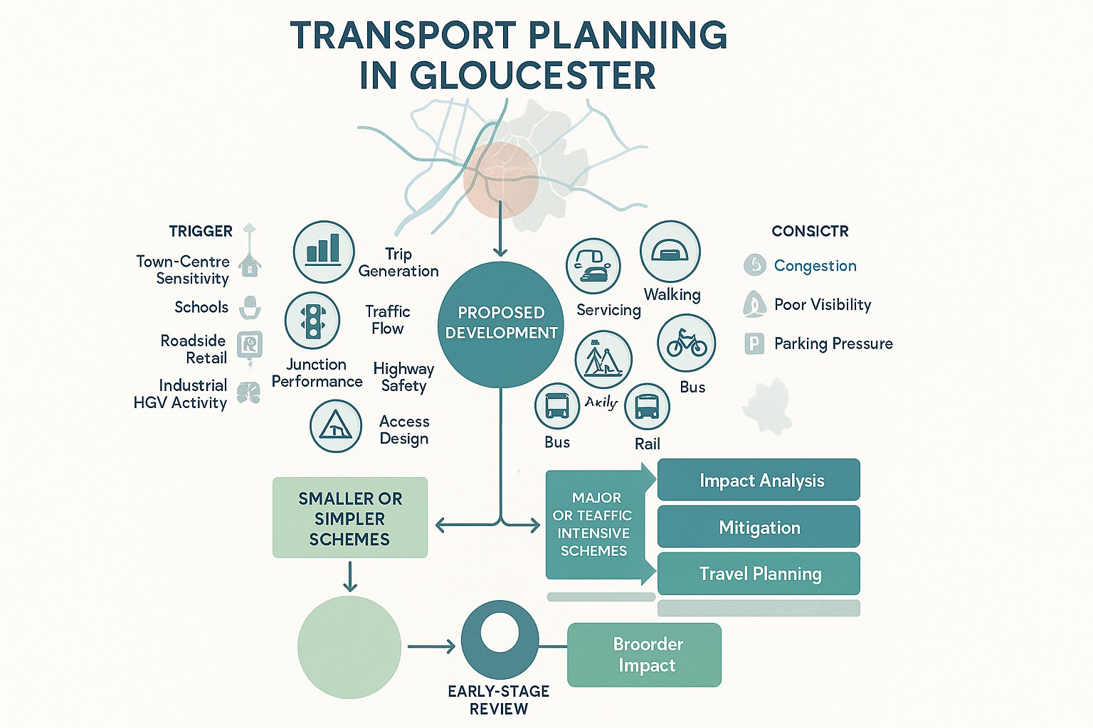
That usually includes trip generation, traffic distribution, junction operation, highway safety, access design, parking provision, servicing arrangements, and opportunities for walking, cycling, bus, and rail travel. On some sites, the emphasis falls on one issue, perhaps a tight access geometry or constrained servicing yard. On others, especially larger mixed-use or residential schemes, the focus expands to cumulative traffic impact, mitigation, and longer-term Travel Plan measures.
A transport submission is generally needed where a proposal may materially affect the highway network or local travel patterns. That tends to include major development, traffic-intensive uses, sensitive town-centre locations, schools, care uses, roadside retail, industrial schemes with frequent HGV movements, and sites with known safety or congestion issues. Smaller schemes can trigger transport work too, particularly where access visibility is poor, on-street parking pressure is already high, or policy support depends on sustainable travel credentials.
The key point is proportionality. Not every application needs a full Transport Assessment, but most sites benefit from some transport planning input early on. In our experience, identifying likely triggers at feasibility stage is usually cheaper, and much less painful, than trying to retrofit a justification once comments come back from consultees.
How Gloucester’s Planning Context Shapes Transport Requirements
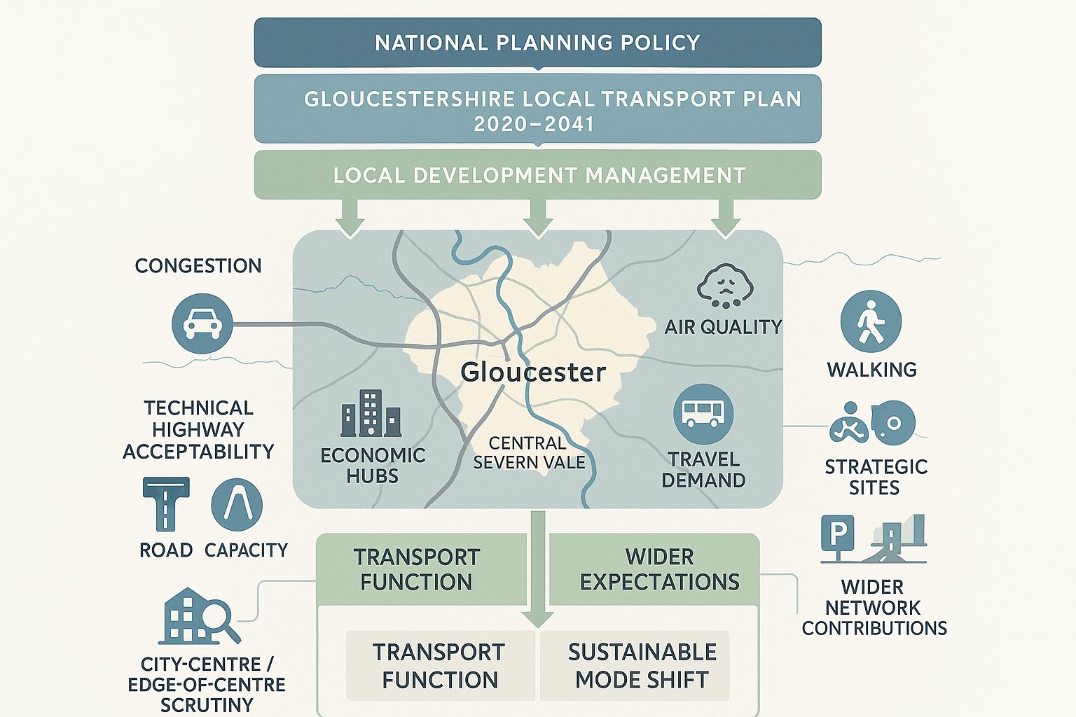
Gloucester’s transport requirements are not created in a vacuum. They sit within the wider policy framework of the Gloucestershire Local Transport Plan (LTP) 2020–2041, alongside national planning policy and local development management practice. That matters because the LTP does not just talk in broad aspirations: it influences how transport impacts are judged at application stage.
For Gloucester, the county’s strategy places strong emphasis on the Central Severn Vale context, where Gloucester and Cheltenham function as key economic and movement hubs. In plain English: there is pressure on the network, pressure on air quality in certain corridors, and growing expectation that new development will support mode shift rather than simply accommodate more private car trips.
So transport planning in Gloucester often has to do two things at once. First, it must demonstrate that a proposal is technically workable in highway terms. Second, it must show that the development responds to wider policy objectives around active travel, public transport access, and network management. A technically acceptable junction can still attract challenge if the overall package ignores obvious walking or cycling links, underplays bus accessibility, or relies too heavily on car-based assumptions.
This is particularly relevant in city-centre and edge-of-centre locations, where land-use intensity, parking expectations, and sustainable access opportunities are all scrutinised more closely. It also affects strategic sites, where the authority may expect phased mitigation, internal movement strategies, or contributions tied to wider network improvements.
In short, local context shapes both the scope of the report and the standard of explanation needed to make it persuasive.
Local Highway Authority Expectations And Common Validation Triggers
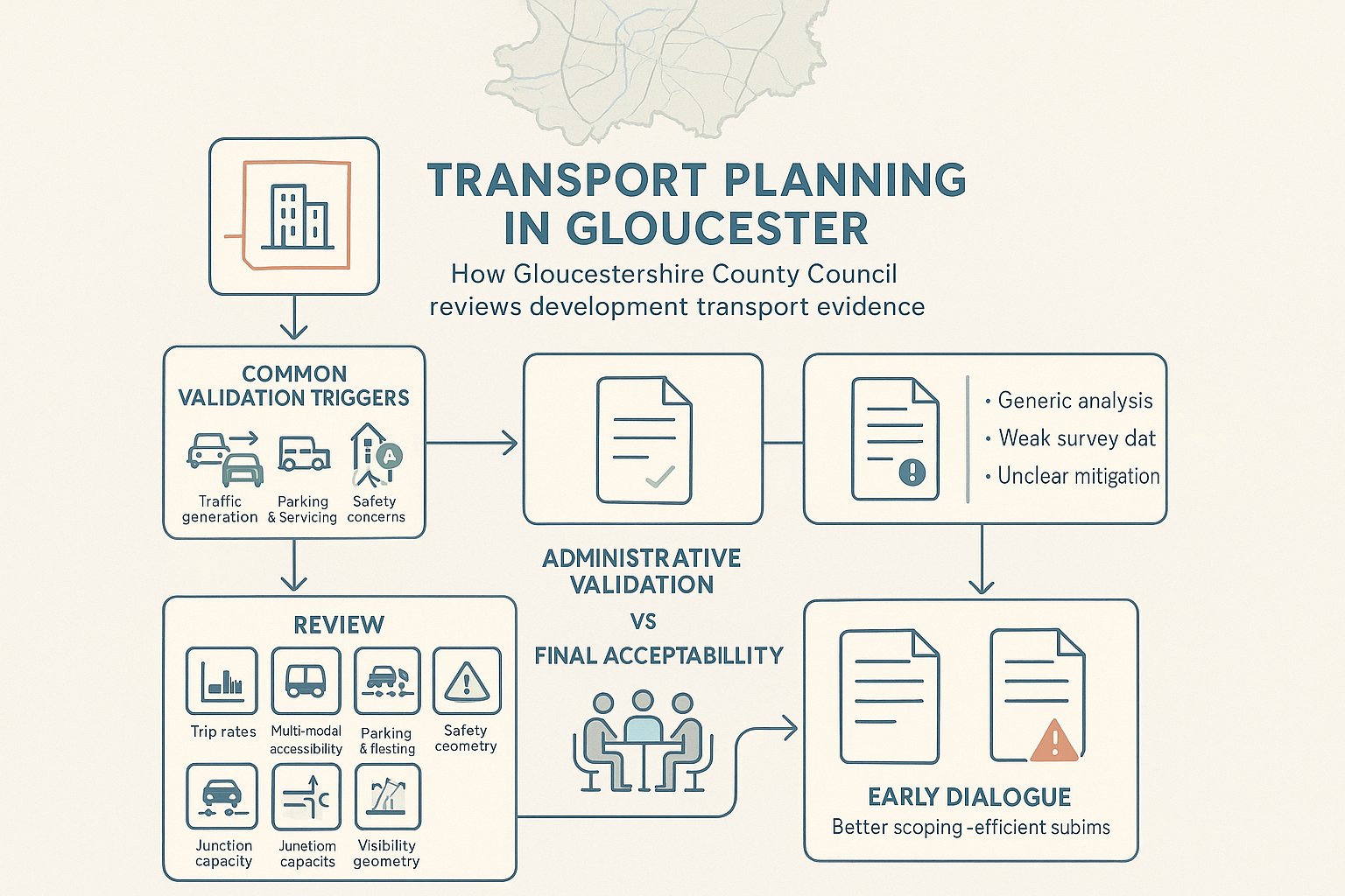
Gloucestershire County Council, acting as local highway authority, is central to how transport evidence is framed and reviewed. While each application turns on its own merits, the authority will typically expect transport documents to be proportionate, site-specific, and clearly linked to the scale and type of development proposed.
Common validation triggers include major development thresholds, uses likely to generate noticeable traffic, schemes on constrained frontage roads, and proposals where access, parking, servicing, or safety are already live concerns. Travel Plans are often expected for larger employment, education, healthcare, residential, and mixed-use proposals, especially where policy support depends on reducing reliance on single-occupancy car trips.
There is also a practical point that sometimes gets overlooked: validation and acceptability are not the same thing. A report may be submitted, tick the list administratively, and still be found lacking because the analysis is too generic, the survey data is weak, or the mitigation is not clearly tied to identified impacts.
Typical authority expectations include:
- clear red-line and access drawings
- robust trip-rate justification
- realistic multi-modal accessibility review
- parking and cycle provision evidence
- servicing and refuse collection tracking where relevant
- junction capacity analysis for affected nodes
- road safety review, often including collision data
- visibility splays and geometry to accepted standards
Early dialogue helps. When scoping is agreed upfront, applicants are less likely to waste time producing either too little evidence or a bloated document that answers the wrong questions.
The Main Transport Reports Used For Planning Applications
Most Gloucester planning applications do not need every possible transport document. But they do need the right ones. Choosing the correct report set is one of the simplest ways to avoid delay, because the authority wants evidence that is proportionate, readable, and directly relevant to the planning issues in play.
At the lighter end, a concise transport note may be enough to address access, parking, and basic trip expectations. At the heavier end, a full package may include a Transport Assessment, Travel Plan, site access appraisal, swept path analysis, capacity modelling, and a parking or servicing review.
The balance depends on scale, use class, location, and sensitivity of the surrounding network. A modest infill residential scheme on a calm street is a different proposition from roadside retail near a busy corridor, or a logistics unit with regular articulated vehicle movements. That sounds obvious, but many weak submissions still rely on standard templates that could have been written for almost any site in the country.
For Gloucester schemes, the strongest reports usually have three characteristics. They are proportionate. They are rooted in local conditions. And they connect transport evidence to planning strategy rather than treating it as a separate engineering appendix nobody really wants to read.
Below are the main report types we see used most often and the role each tends to play in moving an application forward.
Transport Assessments, Transport Statements, And Travel Plans
A Transport Assessment (TA) is the most detailed of the standard planning transport reports. It is normally prepared for major or traffic-intensive proposals and examines baseline conditions, predicted trips, distribution patterns, junction effects, accessibility, and mitigation. In Gloucester, a TA often needs to show not only that the road network can accommodate development, but that the scheme has been planned in a way that supports walking, cycling, and public transport where these are realistic options.
A Transport Statement (TS) is lighter-touch. It is suitable for smaller or less impactful schemes where a full TA would be disproportionate. That does not mean it can be vague. A good TS still needs to explain the proposal, likely movements, access arrangements, parking, servicing, and any local constraints. Think of it as concise, not casual.
A Travel Plan is different again. Rather than focusing only on impact, it sets out how travel behaviour will be influenced over time. This can include welcome packs, cycle facilities, bus information, car-share measures, monitoring, and targets. For larger Gloucester developments, especially employment, school, healthcare, or residential-led schemes, a Travel Plan can be a significant part of the planning package.
The mistake we sometimes see is treating the Travel Plan as an afterthought. In policy terms, it is often one of the clearest demonstrations that a scheme aligns with the LTP’s direction on mode shift. If the TA explains what the impact is, the Travel Plan helps explain how that impact will be managed.
Site Access Appraisals, Swept Path Analysis, And Parking Reviews
Some planning issues are not about network capacity at all. They are about whether vehicles can physically and safely get in and out of a site, whether parking is workable, and whether servicing has been designed around reality rather than hope.
A site access appraisal typically looks at frontage conditions, visibility splays, access width, junction form, gradients, pedestrian interaction, and how the proposal fits with the surrounding highway environment. On constrained Gloucester sites, particularly conversions, infill plots, and edge-of-centre commercial premises, this can be the document that makes or breaks an application.
Swept path analysis shows whether vehicles can manoeuvre safely within the site and at the access point. This is essential where refuse vehicles, delivery vans, emergency appliances, or articulated HGVs need to enter, turn, load, and exit. If tracking is missing for a site that clearly requires it, objections are almost inevitable.
A parking review examines the quantum, layout, accessibility spaces, cycle provision, turning, and often the relationship with local parking stress. For city-centre Gloucester sites, under-provision may be justified if sustainable travel options are strong. Elsewhere, undercooked parking arguments can lead to concerns about overspill parking, neighbour impact, and operational conflict.
These documents are sometimes seen as technical add-ons. In truth, they are often where the local authority tests whether a scheme has been designed properly at all.
Key Transport Planning Considerations For Gloucester Development Sites
Gloucester sites vary hugely. A central urban redevelopment plot, an edge-of-centre student scheme, a suburban care home, and a strategic expansion site will not be assessed in the same way, nor should they be. The transport issues change with scale, context, frontage conditions, and surrounding travel options.
Still, a few themes recur again and again. The first is constraint. Gloucester contains historic streets, busy corridors, sensitive junctions, and areas where there is simply not much room to solve problems physically. The second is expectation. Policy increasingly pushes development to make genuine use of sustainable travel opportunities, especially where bus routes, rail access, or walkable destinations are nearby. The third is credibility. If a submission claims low car dependency in a location that plainly functions car-first, reviewers will notice.
This means transport planning in Gloucester has to be realistic as well as policy-aware. Applicants need to understand where flexibility exists and where it doesn’t. Parking can sometimes be argued down. Vehicle tracking cannot be wished away. Cycle links can support a case strongly, but only if they are direct, safe, and useful in everyday terms.
The sections below look at how this plays out across different Gloucester site types and the recurring issues around sustainable travel, servicing, and safety.
City Centre, Edge-Of-Centre, And Strategic Expansion Locations
In city-centre Gloucester, transport work often revolves around constraint, accessibility, and operational practicality. Streets may be tighter, pedestrian activity higher, and parking provision more politically and technically sensitive. The upside is that central sites can often make a stronger case on sustainable travel. If a development is within easy reach of jobs, services, bus corridors, and the rail station, lower car trip assumptions or reduced parking can be more credible, provided the evidence is honest and the Travel Plan is not tokenistic.
Edge-of-centre sites are trickier. They can have some sustainable advantages without quite delivering the convenience of the centre. Here, transport planning needs to be nuanced. Walking routes may look short on a plan but feel poor in practice because of severance, crossing difficulty, lighting, or steep gradients. Bus accessibility may exist, but frequency and destination coverage matter. This is where a site-specific audit adds real value.
For strategic expansion locations and larger urban extensions, the scope broadens significantly. The authority may expect phased access strategies, internal street hierarchy, public transport penetration, walking and cycling connections, and mitigation linked to nearby junctions or corridors. Cumulative impact becomes more important too, particularly where other allocations or committed developments are in play.
Different location types demand different evidence. A one-size-fits-all transport narrative almost always feels thin, because it is.
Sustainable Travel, Servicing, And Highway Safety Issues
Three issues repeatedly sit at the centre of Gloucester transport reviews: sustainable travel, servicing, and highway safety.
Sustainable travel is no longer a polite extra. Authorities increasingly expect developments to show how walking, cycling, and public transport have shaped the layout and access strategy from the outset. That includes pedestrian links, crossing points, cycle storage, connection to local routes, and realistic assessment of bus access. We say realistic because overstating weak provision is one of the quickest ways to undermine an otherwise decent report.
Servicing is often underappreciated until late in the day. Retail, industrial, food, residential, and mixed-use schemes all need practical arrangements for deliveries, refuse, maintenance, and emergency access. Questions include: Can vehicles enter and leave in forward gear? Will servicing block parking aisles or shared surfaces? Are delivery times compatible with nearby residential uses? A neat site plan can conceal awkward operations if tracking and management assumptions are not properly tested.
Highway safety remains fundamental. Visibility, access geometry, speed environment, collision history, pedestrian crossing risk, and internal conflict points all matter. Even where network capacity is acceptable, a scheme can face resistance if the authority is not persuaded that the access is safe for all users, including cyclists and pedestrians.
The strongest transport planning in Gloucester brings these strands together. It shows not only that a scheme can function, but that it can function safely, efficiently, and in a way that matches policy expectations.
The Transport Planning Process From Feasibility To Decision
A good transport submission usually starts long before the planning application is uploaded. At feasibility stage, we need to understand the site context, development quantum, likely access points, known constraints, and whether there are obvious red flags around capacity, visibility, servicing, or parking. This early review is where proportionate strategy is set: full TA, TS, access note, Travel Plan, or a wider package.
The next step is baseline evidence. That may include traffic surveys, queue observations, collision data, speed surveys, public transport review, walking and cycling audits, parking beat surveys, or vehicle tracking assumptions. Once the baseline is clear, trip generation and distribution can be established and the likely network effects assessed.
From there, design and mitigation evolve together. Access geometry may change. Parking layouts may need reworking. A better pedestrian route might strengthen the overall planning case. Sometimes the transport work does not merely support the design, it materially improves it.
Where appropriate, early scoping with Gloucestershire County Council can be invaluable. It helps confirm the likely level of assessment, modelling expectations, and whether particular junctions, standards, or Travel Plan measures are likely to be scrutinised.
After submission, consultation comments often focus on gaps rather than headline conclusions. If those gaps are small, they can be addressed quickly. If they reveal that the scheme was never properly tested, delay becomes much more likely.
That is why experienced, locally aware input matters. At ML Traffic, for example, the value is not just producing a report quickly: it is producing one that is calibrated to local authority thresholds and the planning context the application will actually face.
Common Reasons Transport Evidence Delays Planning Applications
Most transport delays are avoidable. They rarely come from the existence of a problem alone: they come from discovering the problem too late, explaining it poorly, or submitting evidence that does not match the site.
One common issue is the wrong report type. A short note is submitted where a Transport Statement was plainly needed, or a TS is prepared for a scheme whose scale and sensitivity really justify a full TA. The authority then asks for more work, and the timetable slips.
Another frequent problem is weak baseline data. Out-of-date traffic counts, generic trip rates without proper justification, missing collision analysis, or vague accessibility commentary all make it harder for reviewers to trust the conclusions.
We also see delays caused by underdeveloped access design. Visibility splays are shown but not achievable. Swept path drawings are absent. Parking layouts ignore turning needs or fail to account for cycle storage and servicing. On paper, everything fits. On site, it probably doesn’t.
Then there is policy misalignment. If a Gloucester scheme says sustainable travel opportunities are limited when nearby bus routes, footways, or cycle links suggest otherwise, that invites challenge. Equally, claiming strong mode shift potential without credible supporting measures does the same.
Finally, late coordination between planning, architecture, highways, and legal teams can be surprisingly costly. A red-line change, new unit mix, or altered servicing arrangement can quietly invalidate earlier transport work. And suddenly a nearly-ready application is back in draft.
How To Prepare A Stronger Submission For Gloucester Schemes
The strongest Gloucester submissions are usually the ones that feel joined up. Not over-engineered, not padded with unnecessary appendices, just coherent, proportionate, and clearly rooted in the site.
First, start early. Even a brief feasibility review can flag whether the real risk sits with access, parking, junction impact, or policy positioning. That gives the wider consultant team a fair chance to respond before layouts harden.
Second, scope the work properly. Where possible, engage early with Gloucestershire County Council so the expected level of assessment is understood. This can save a surprising amount of time and expense, particularly on schemes that sit near the boundary between a TS and a TA.
Third, build the transport case around local reality. That means using site-specific access analysis, credible trip-rate selection, honest commentary on walk and cycle routes, and practical servicing assumptions. If a route is unattractive or discontinuous, say so, then explain the consequence. Candour tends to land better than spin.
Fourth, align with the Gloucestershire LTP 2020–2041. Show how the proposal supports mode shift, network management, and safe multi-modal access where relevant. For many applications, this policy alignment is what turns a technically adequate report into a persuasive one.
Finally, make the package easy to review. Clear plans, concise reasoning, consistent numbers, and properly labelled appendices go a long way. Planning officers and highway reviewers should not have to hunt for the answer to basic operational questions.
In our experience, that combination, early strategy, proportionate evidence, and local policy awareness, gives Gloucester schemes the best chance of a smoother planning journey.
Conclusion
Transport planning in Gloucester is rarely just a box-ticking exercise. It sits at the intersection of design, policy, movement, safety, and deliverability. When it is handled early and proportionately, it can sharpen a scheme, reduce risk, and make planning conversations more straightforward. When it is left late, it tends to expose weaknesses nobody enjoys unpicking under deadline.
For teams preparing applications in 2026, the main lesson is simple: match the evidence to the site, the scale, and the local context. Gloucester’s transport expectations are shaped by the county’s wider strategy, and successful submissions usually reflect that from the start.
Whether the issue is a full Transport Assessment, a concise Transport Statement, a Travel Plan, access tracking, or parking justification, quality matters more than volume. A clear, locally informed report will usually outperform a generic one twice the length.
And that is really the heart of planning success here, not more paperwork, but better judgement, earlier in the process.
Transport Planning in Gloucester: Frequently Asked Questions
What does transport planning in Gloucester typically involve?
Transport planning in Gloucester covers trip generation, traffic distribution, junction operation, highway safety, access design, parking, servicing, and promoting walking, cycling, and public transport, ensuring developments can be accessed safely and efficiently while supporting local transport goals.
When is a Transport Assessment required for a planning application in Gloucester?
A Transport Assessment is generally required for major or traffic-intensive developments that may significantly affect the highway network or local travel patterns, such as large residential, commercial, or mixed-use schemes, in line with Gloucestershire’s transport policy.
How does the Gloucestershire Local Transport Plan influence transport planning in Gloucester?
The Local Transport Plan 2020–2041 guides transport planning by emphasizing mode shift from private cars, congestion management, safety, and integration with land use, shaping requirements for sustainable travel, access design, and mitigation measures in planning applications.
What are common reasons transport evidence causes delays in Gloucester planning applications?
Delays often occur due to submitting incorrect report types, weak or out-of-date baseline data, inadequate access or parking design, non-compliance with local policies, and late coordination between project teams, all of which affect credibility and review efficiency.
How can developers improve the chances of successful transport planning submissions in Gloucester?
Developers should engage early with Gloucestershire County Council for scoping, provide proportionate and locally relevant transport evidence, align proposals with Local Transport Plan policies on sustainable travel and network management, and ensure clear, concise, and coordinated transport reports.
What role do Travel Plans play in Gloucester’s transport planning process?
Travel Plans outline how a development will manage and reduce car use over time through measures like cycle facilities, bus information, and car-sharing, demonstrating alignment with mode shift objectives and forming a key part of the planning package for larger developments.