A fast food restaurant with no drive through transport assessment is often underestimated at the early design stage. We see it quite a lot: because there’s no drive-through lane, applicants assume highways impacts will be modest and the planning process straightforward. In practice, that assumption can unravel quickly.
A no-drive-through format may still generate a noticeable volume of customer arrivals, rider collections, staff trips, servicing activity and short-stay parking demand, especially in town centres, edge-of-centre parades, near schools, or on streets that are already under pressure. And in 2026, planning officers and local highway authorities are looking for evidence that is much more precise than a generic statement saying trips will be “limited”.
What they usually want is a concise, site-specific and policy-led case: how people will travel, when peaks will occur, whether the kerbside can cope, what happens with delivery riders, and whether nearby junctions or pedestrian routes are likely to be affected. That is the real job of a Transport Assessment.
In this guide, we set out what planning officers typically expect from a transport assessment for a fast food restaurant without a drive-through, where the common pressure points are, and how to prepare evidence that is credible first time. Drawing on the kind of work we produce at ML Traffic, the focus here is practical: the issues that actually influence validation, consultation responses and planning decisions.
When A No-Drive-Through Fast Food Use Needs A Transport Assessment
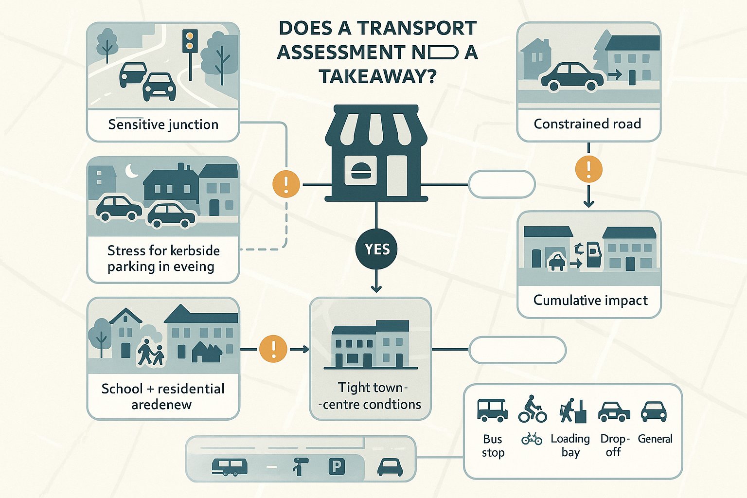
Whether a Transport Assessment is needed depends less on the brand or label of the use and more on material transport impact. A small takeaway unit on a highly walkable high street may not need a full TA. A similar-sized proposal on a constrained road, close to a busy junction or in a location with parking stress, often will.
In the UK, local planning authorities and highway authorities usually set validation expectations through local lists, parking standards, transport guidance and development management practice. Floorspace thresholds can trigger a TA or a lighter Transport Statement, but those thresholds are only the start. A no-drive-through scheme may still require formal assessment where:
- the site sits on or near a sensitive junction:
- the road network already experiences queueing or unsafe manoeuvres:
- there is likely to be evening parking pressure:
- the use changes from a lower-trip former use to hot food takeaway:
- schools, residential frontages or heavy pedestrian flows are nearby: or
- cumulative impact with neighbouring uses is a realistic concern.
We also find that a proposal in a conservation area, district centre or tightly managed town centre often attracts more scrutiny because the kerbside is already doing too many jobs at once: loading, blue badge parking, buses, cycling movement, drop-offs and general parking.
So the sensible question is not “does no drive-through mean no TA?” It’s “can we evidence that this use can operate safely and acceptably on this street?” If the answer is not obvious, a transport assessment is usually the right tool.
How Trip Generation Differs From Drive-Through And Dine-In Formats
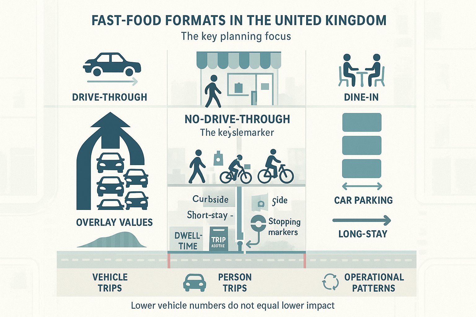
This distinction matters because applicants sometimes borrow assumptions from the wrong format. A drive-through restaurant typically creates a stronger vehicle-led peak, shorter customer dwell times, higher turnover of cars and a greater risk of on-site or off-site queueing. That model is traffic-intensive by design.
A no-drive-through fast food unit behaves differently. Even where there is seating, the trip profile often includes a broader mix of:
- walk-in customers:
- app-based collections:
- staff arrivals by public transport or car:
- cycle or motorcycle delivery riders:
- short-stay pick-up activity on nearby streets.
That usually means fewer car trips than a drive-through equivalent, but not necessarily fewer transport issues. The pressure simply shifts. Instead of a lane stacking problem, the key issue may be kerbside churn, informal stopping, repeated rider arrivals, or customers parking “just for two minutes” on a narrow frontage.
Dine-in formats can also have longer average dwell times than pure collection uses, which affects parking accumulation. Collection-led units may have shorter stays but sharper surges around lunch and evening delivery periods. And if third-party delivery platforms are involved, trading intensity can rise quite quickly after opening.
For planning purposes, we hence need to distinguish between vehicle trip numbers, person trip numbers, and operational patterns. A lower-vehicle format is not automatically a low-impact format. Officers generally respond well when that nuance is recognised rather than glossed over.
Key Planning And Highway Issues For Hot Food Takeaway Schemes
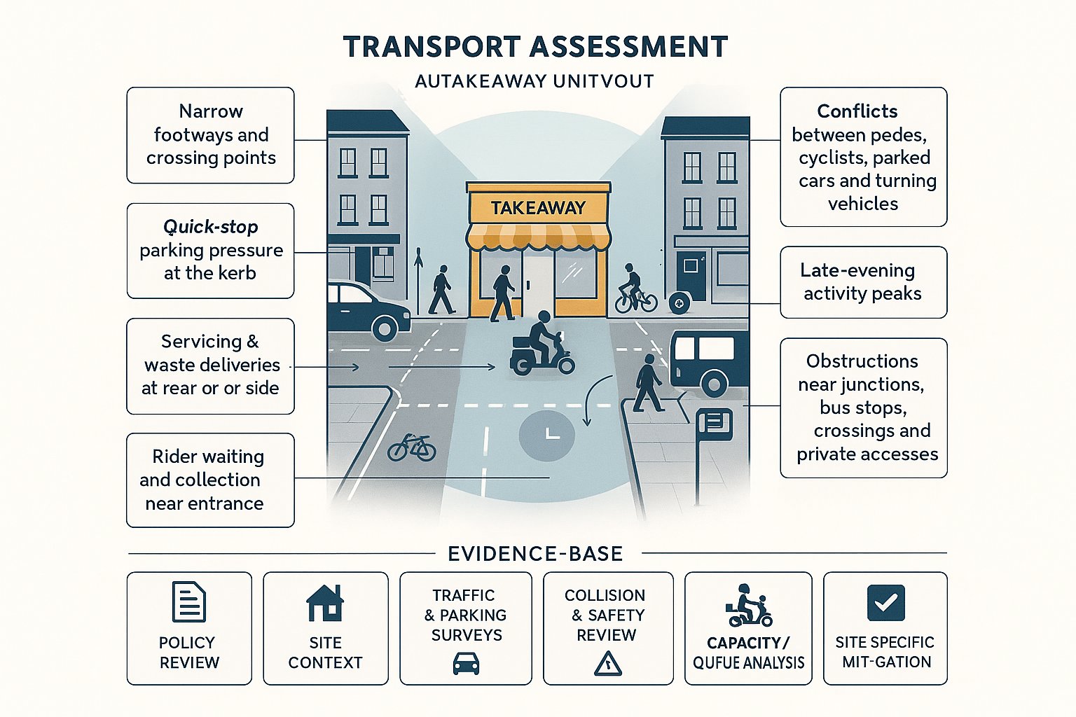
Hot food takeaway proposals tend to raise a recognisable set of transport concerns, even where the premises has no drive-through. Some are classic highways points: others sit on the boundary between transport, amenity and day-to-day street management.
The recurring issues include:
- safe access for all users, especially on streets with narrow footways or frequent crossing movements:
- parking stress caused by quick-stop customer activity:
- servicing arrangements for food, waste and consumables:
- rider waiting and collection space:
- conflicts between pedestrians, cyclists, parked vehicles and turning traffic:
- late evening peaks that do not align neatly with standard commuter traffic periods:
- obstruction near junctions, crossings, bus stops or private accesses.
Officers also look closely at whether the proposal changes the rhythm of the street. A former retail unit might have generated dispersed daytime visits. A takeaway can compress activity into lunch and evening windows, with a different noise and parking profile. On mixed-use streets, that can become a planning issue very quickly.
Another point that is often missed: the highway authority is not only interested in the site access itself. It will consider the zone of influence around the site, particularly where customers are likely to stop on surrounding streets rather than in formal bays. If those conditions lead to blocking visibility splays, awkward reversing, or pressure on vulnerable road users, transport objections become much more likely.
What Local Authorities Usually Want To See In The Evidence Base
At minimum, local authorities usually expect a clear and proportionate evidence base rather than generic text copied from another application. In most cases that means:
- a review of national and local policy relevant to trip impact, parking, accessibility and safety:
- a site description covering frontages, access points, surrounding roads and nearby sensitive receptors:
- baseline traffic, parking beat surveys or kerbside observations, where relevant:
- personal injury collision data and a short safety review:
- trip generation and modal split assumptions from credible comparable evidence:
- capacity or queueing analysis where local conditions indicate a potential issue:
- a servicing, delivery and rider management strategy:
- mitigation measures tied directly to identified impacts.
The stronger submissions are selective and specific. They show what matters on that particular site and why. The weaker ones dump standard paragraphs into a report and hope no one notices. They usually do.
Defining The Site, Catchment, And Local Transport Context
A robust assessment starts by defining the site properly. That sounds basic, but it is where many weak reports drift off course. If the red line boundary, frontage conditions, nearby restrictions and realistic customer catchment are not clearly set out, the rest of the analysis becomes shaky.
We normally begin with three layers.
First, the site boundary and immediate frontage: access points, nearby junctions, footway widths, crossing points, loading opportunities, parking controls, bus stops and any physical constraints such as bollards, trees or guardrailing.
Second, the functional catchment: where customers, staff and riders are realistically coming from. In urban areas, that should usually include walk-time and cycle-time isochrones, as well as public transport accessibility. A town-centre takeaway may draw heavily from a 5 to 10 minute walk catchment. An edge-of-centre unit might rely more on short car trips and app-based collections.
Third, the wider network context: nearby strategic junctions, one-way systems, school streets, controlled parking zones, bus corridors and any known congestion points.
The point is to avoid abstract assumptions. If the surrounding area is highly walkable with frequent bus services, that should shape modal split expectations. If the site sits on a narrow road with limited lawful stopping opportunities, that should shape the kerbside and mitigation strategy.
Planning officers tend to trust assessments that show a grounded understanding of place. It tells them we are analysing the scheme that is actually being proposed, not a generic fast food unit in theory.
Assessing Existing Access, Servicing, And Street Constraints
Even without a drive-through lane, access and servicing can become the make-or-break issue. That is especially true where the unit occupies an existing parade with no rear service yard, limited frontage depth and a street already cluttered with competing demands.
A good assessment should examine the practical realities of operation:
- how staff enter and leave the site:
- where food and stock deliveries will stop:
- whether refuse collection creates temporary obstruction:
- whether any vehicle can turn, unload and depart lawfully:
- how riders wait and collect orders:
- whether customer stopping is likely to occur in formal bays or informally on-street.
Visibility is still relevant, but for these sites the bigger question is often operational fit. Can the surrounding street absorb the pattern of activity the use will create?
We would usually review frontage width, carriageway width, parking restrictions, loading bans, bus stop clearways, nearby side roads and pedestrian desire lines. If there is no on-site servicing, the report should not pretend otherwise. It should explain the workable arrangement and demonstrate why it is acceptable.
Street constraints matter because a seemingly minor issue can trigger objection. One delivery van stopping across a cycle lane every evening is not minor to the highway authority. Nor is repeated customer stopping within a junction taper.
The most persuasive reports are honest about constraints and then show how those constraints will be managed through timed deliveries, loading practice, rider protocols or formal kerbside changes where needed.
Trip Generation, Modal Split, And Peak Period Assessment
Trip generation is the core of the case. If the assumptions are weak, everything built on them is vulnerable. For a fast food restaurant with no drive through transport assessment, officers will expect a reasoned estimate of person trips and vehicle trips by time period, not a broad assertion that impacts will be low.
Comparable survey data remains important, whether drawn from TRICS-style evidence, local surveys, operator information or a carefully justified blend of sources. But raw comparables are rarely enough on their own. They need adjustment for location, format, seating, opening hours, delivery reliance and local accessibility.
Modal split should reflect the catchment and the street, not national averages lifted out of context. A city-centre site near multiple bus routes may have a high walk-in share. A suburban roadside site may not. Staff travel patterns should also be considered separately from customer patterns.
Peak periods need thought. Standard weekday AM peak analysis may be irrelevant for a takeaway that trades most heavily in the evening. We usually align the assessment with both network peak conditions and operational peak trading periods, because the authority may care about each for different reasons.
Where there is a material reassignment from a former lawful use, it may also be necessary to consider net impact rather than gross trips alone. That can help, but only if the benchmark use is realistic and properly evidenced.
How To Consider Delivery Riders, Collection Activity, And Short-Stay Parking
This is where many reports fall short. App-led food operations can generate a steady stream of rider arrivals and customer collections that do not show up neatly in conventional trip tables.
A sound assessment should address:
- rider mode split: cycle, e-bike, motorcycle or car:
- likely waiting locations and dwell times:
- collection surges during lunch and evening periods:
- customer short-stay parking accumulation rather than just arrivals:
- interaction with existing parking controls and nearby private forecourts:
- whether third-party delivery platforms could intensify demand after opening.
Short-stay activity is especially important. Five cars arriving over fifteen minutes is one thing. Five cars overlapping because each waits four to six minutes is another. The kerbside feels the second scenario much more sharply.
Where there is no dedicated pick-up space, the TA should explain exactly where collection activity is expected to occur and whether that is lawful, safe and realistic. If that cannot be shown, mitigation will be needed.
Junction Capacity, Queueing, And Highway Safety Impacts
Not every no-drive-through proposal requires modelling. But where a site sits close to a sensitive junction, on a congested corridor, or in a location with an existing collision pattern, capacity and safety analysis can become essential.
The first step is judgment. Will the likely vehicle trips materially affect operation at a nearby priority junction, signal junction, roundabout or access? If yes, the authority may expect modelling or at least a robust capacity review. For smaller impacts, a qualitative assessment backed by turning counts and observed queueing may be enough.
Queueing is not only about strategic delay. It is also about local blocking effects: right-turners pausing in the carriageway, vehicles stopping near crossings, or informal waiting that reduces effective road width. Around takeaway sites, these micro-effects can matter more than headline daily traffic totals.
Safety review should usually include recent personal injury collision data, site observations and an appraisal of vulnerable road users. We would look for patterns involving crossing pedestrians, cyclists filtered around parked vehicles, or shunt-type incidents near accesses and junctions.
A common mistake is to say there is “no significant highway safety issue” simply because no access changes are proposed. That misses the real point. A change of use can alter roadside behaviour even if the physical access remains untouched.
If there is a credible risk of unsafe stopping, turning conflict, obscured visibility or pedestrian pressure, the TA needs to confront it directly. Planning officers are much more receptive to a balanced report than to one that appears defensive.
Walking, Cycling, Public Transport, And Accessibility Expectations
By 2026, accessibility evidence is not an optional extra. Planning officers increasingly expect applicants to demonstrate that a site can be reached by sustainable modes and that the proposal does not undermine local walking and cycling conditions.
For takeaway and fast food uses, this matters in two ways. First, good accessibility can legitimately support lower car trip assumptions. Second, poor conditions for non-car users can become a planning issue in their own right, particularly where the frontage is cramped or rider activity spills onto footways.
A useful accessibility assessment will normally cover:
- footway continuity, width and crossing opportunities:
- pedestrian desire lines to nearby residential areas, schools and public transport stops:
- cycle routes, local cycling permeability and the quality of any nearby facilities:
- bus stop proximity, service frequency and realistic staff/customer access by public transport:
- accessibility for disabled users, including dropped kerbs and step-free routes where relevant.
This section should connect to design and operations, not sit in isolation. If the proposal relies on walk-in trade, the walking environment needs to support that claim. If riders are expected to arrive by cycle or e-bike, secure and non-obstructive cycle parking arrangements become relevant.
National policy and local plans increasingly push developments toward sustainable travel, but officers are generally pragmatic. They do not expect a small urban takeaway to transform travel behaviour. They do expect us to show that the proposal fits its location, supports realistic non-car access and does not create avoidable friction for people moving past the site.
Mitigation Measures That Can Support A Planning Application
Mitigation works best when it is tightly matched to the identified problem. Generic promises to “encourage sustainable travel” rarely carry much weight unless they are backed by something practical and enforceable.
Depending on the site, useful measures can include:
- revised access arrangements or localised frontage changes:
- improved visibility where geometry allows:
- formal short-stay parking or loading arrangements:
- changes to waiting restrictions or a Traffic Regulation Order, where justified:
- timed servicing to avoid sensitive periods:
- rider management protocols and designated collection/waiting space:
- staff travel measures, cycle parking and public transport information:
- contributions to junction or crossing improvements where impacts warrant them.
Sometimes the best mitigation is operational rather than physical. For example, restricting delivery windows, using smaller servicing vehicles, or managing app-based collections more actively can reduce pressure on the kerb. But operational mitigation needs to be credible. If compliance depends on perfect behaviour from customers, officers may not give it much weight.
We often find that early discussion with the highway authority helps narrow what is proportionate. Not every site needs expensive works. Some need a clear servicing plan and a realistic parking strategy. Others genuinely need kerbside changes or highway amendments to function acceptably.
The key is that mitigation should make the authority’s job easier: it should show not just that impacts exist, but that there is a workable route to keeping them within acceptable limits.
Common Reasons These Applications Are Delayed Or Refused
Most delays and refusals are not caused by the existence of a takeaway use alone. They usually arise because the transport case is too thin, too generic or too optimistic.
The common problems are familiar:
- trip rates taken from unsuitable comparables with no local adjustment:
- no proper treatment of delivery riders or app-based collection demand:
- failure to assess short-stay parking and kerbside effects:
- claiming no material impact near a junction without evidence:
- omitting collision review or safety appraisal where the location is clearly sensitive:
- relying on a former use comparison that is unrealistic in practice:
- proposing mitigation that is vague, unenforceable or outside the applicant’s control:
- limited or late engagement with the highway authority.
Another delay point is basic inconsistency between documents. If the TA assumes one level of seating, one set of opening hours and one delivery profile, while the planning statement or application form says something else, confidence in the submission drops fast.
We also see issues where applicants underplay evening activity because standard daytime surveys look acceptable. But many objections arise from how the site will work at 6pm to 10pm, not 8am to 9am.
A refusal can often be traced back to one simple concern left unanswered: where will people stop, and what happens when they do? If that question is not resolved with evidence, officers tend to take a cautious view.
Preparing A Robust Transport Assessment And Supporting Documents
A strong submission is concise, site-specific and proportionate. It does not try to bury weaknesses under volume. It identifies the real transport issues, analyses them properly and, where necessary, proposes mitigation that can actually be delivered.
For most no-drive-through fast food proposals, the supporting pack should be assembled as a joined-up set of documents rather than isolated reports. Depending on the site, that may include:
- a Transport Assessment or Transport Statement:
- a Framework Travel Plan where required:
- a Delivery and Servicing Plan:
- parking or kerbside survey evidence:
- swept path or access drawings if servicing is tight:
- road safety or collision analysis:
- supporting plans showing cycle parking, loading, rider space and frontage arrangements.
The TA itself should explain the proposal clearly, define the baseline, justify trip generation, test the relevant peak periods, assess access and safety, and set out mitigation in a way the authority can condition or secure if needed.
At ML Traffic, our experience is that speed matters, but clarity matters more. Planning officers and highway consultees respond best to reports that are tailored to local thresholds, local street conditions and the actual operation of the proposed use. That means fewer stock phrases, more observed evidence, and a realistic account of how customers, staff, riders and servicing vehicles will interact with the site.
If the report answers the authority’s likely questions before they have to ask them, the application is in a far stronger position.
For developers, architects, lawyers and planners, that is usually the difference between a transport document that merely accompanies an application and one that actively helps secure permission.
In short, a fast food restaurant with no drive through transport assessment should never be treated as a tick-box exercise. Done properly, it is the document that shows the proposal can function safely, fit its context and satisfy the transport concerns that matter most in 2026.
Frequently Asked Questions about Transport Assessment for Fast Food Restaurants without Drive-Throughs
When is a Transport Assessment required for a fast food restaurant without a drive-through?
A Transport Assessment is needed when the fast food restaurant is above local floorspace thresholds, located near sensitive junctions, in areas with cumulative impacts, or changes use to hot food takeaway in constrained zones, such as near schools or residential streets.
How does trip generation differ between drive-through and no-drive-through fast food restaurants?
Drive-through restaurants generate more vehicle trips, shorter dwell times, and higher peak hour congestion. No-drive-through formats have fewer car trips but involve more walk-in customers, app-based collections, staff trips, and short-stay parking, resulting in different transport and kerbside pressures.
What key transport and highway issues should be considered for no-drive-through hot food takeaways?
Important issues include safe site access, parking stress from short-stay customers, servicing and delivery arrangements, management of delivery riders, pedestrian and cyclist conflicts, evening traffic peaks, and obstruction near junctions and crossings.
How should delivery riders and customer collection activity be addressed in a Transport Assessment?
Transport Assessments must detail rider mode split (cycle, e-bike, motorcycle, car), waiting locations, collection peak surges, short-stay parking accumulation, interaction with parking controls, and potential intensification from third-party delivery platforms to ensure kerbside safety and capacity.
What mitigation measures can support planning approval for fast food restaurants with no drive-through?
Mitigation may include revised access, improved visibility, formal short-stay parking/loading arrangements, waiting restrictions or Traffic Regulation Orders, timed servicing, rider management protocols, travel plans, cycle parking, and contributions to junction improvements where justified.
Why do some applications for no-drive-through fast food restaurants get delayed or refused on transport grounds?
Delays or refusals often result from generic or inadequate trip data, ignoring delivery rider impacts, poor short-stay parking assessment, missing junction capacity or safety analysis, unrealistic former use comparisons, vague mitigation proposals, and lack of early engagement with highway authorities.