Planning applications in 2026 are being judged far more closely on how people will walk and cycle to, from and through a site. That shift isn’t cosmetic. Cycling and walking infrastructure now sits at the centre of transport strategy, placemaking, public health and carbon reduction across the UK. For architects, planners, developers and local authorities, it can influence everything from trip generation assumptions to scheme viability, committee risk and planning conditions.
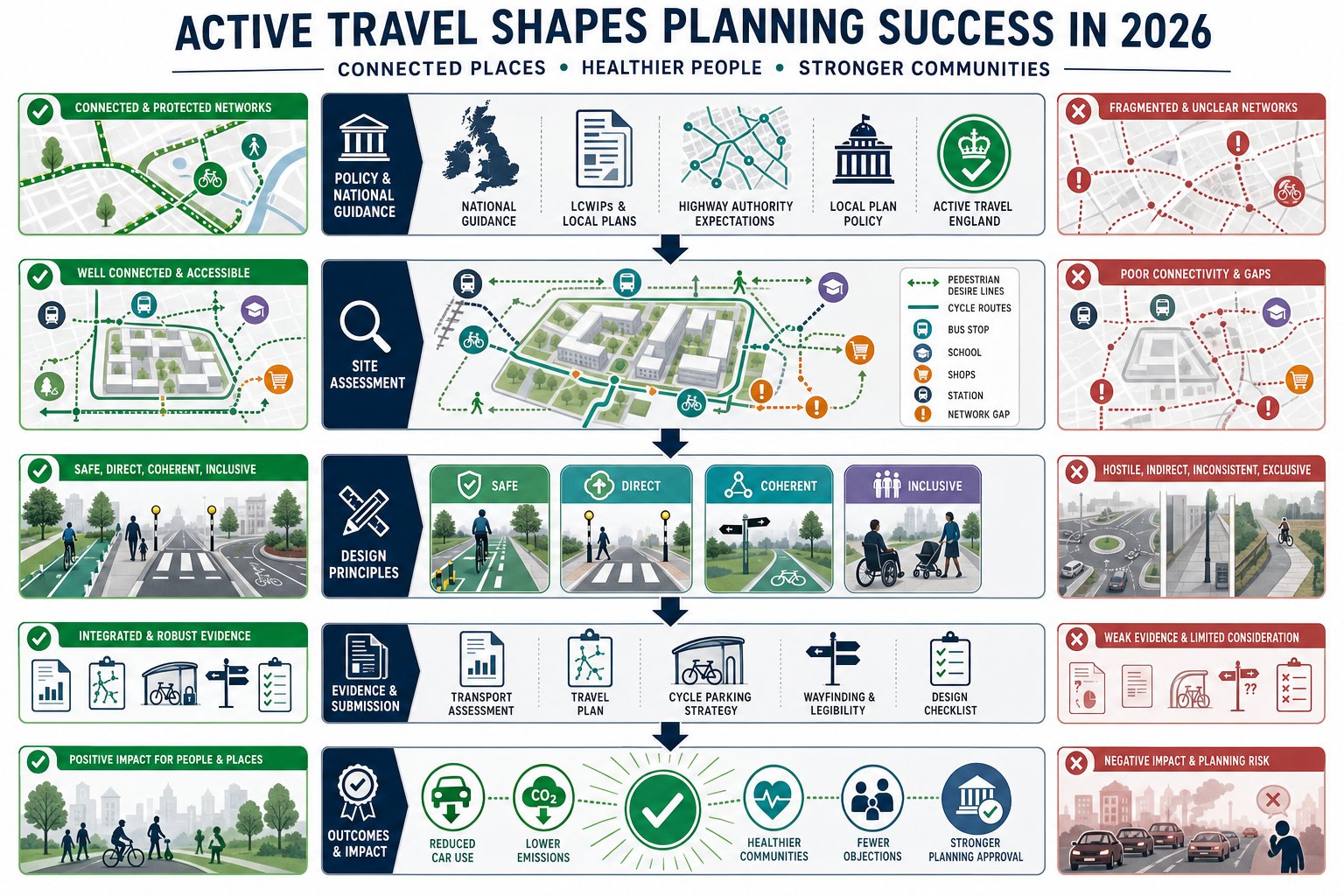
We’re seeing the same pattern across applications of very different sizes: proposals that treat active travel as a bolt-on tend to run into trouble, while schemes that design it in from the start are easier to justify and often easier to move through the planning process. National policy wants walking and cycling to become the natural choice for shorter journeys. Local plans, LCWIPs, highway authority expectations and Active Travel England’s growing influence are all pushing in the same direction.
That means the old approach, a narrow footway here, a shared path there, maybe a token cycle store in the corner, usually isn’t enough. Decision-makers increasingly want evidence that routes are safe, direct, coherent and inclusive, and that they actually connect to where people need to go.
In this guide, we’ll look at what good cycling and walking infrastructure really means in planning and development terms, how to assess a site properly, and where applications most often go wrong.
Why Cycling And Walking Infrastructure Matters In Planning Applications
In planning terms, active travel is no longer a nice extra. It is a core test of whether a development is accessible, sustainable and aligned with policy. If a site can only work comfortably by car, that weakness tends to surface quickly in transport reviews, consultee responses and committee discussions.
Good cycling and walking infrastructure matters because it helps reduce car dependency from day one. That has a knock-on effect on congestion, emissions, parking pressure and even the scale of highway mitigation a scheme may need. It also affects how trip generation is understood. Where a development has safe, legible and attractive walking and cycling connections to schools, shops, bus stops, employment areas and local centres, a stronger case can usually be made for lower car mode share.
There is also a social and economic dimension. Safe active travel routes improve access for people who do not drive, cannot drive, or simply do not want to drive for every short trip. That includes children, older people, disabled people, lower-income households and commuters making linked journeys by foot, cycle and public transport. In other words, the quality of access is often a question of inclusion, not just transport.
From a planning application perspective, this all translates into risk. Weak proposals attract objections because they can appear contrary to national guidance, local policy and adopted network strategies. Strong proposals, by contrast, show that the site has been planned around realistic movement patterns. That is exactly the sort of evidence we aim to set out in concise transport reports at ML Traffic, especially where local authority thresholds and expectations need careful handling.
The Policy And Regulatory Context Shaping Active Travel Schemes
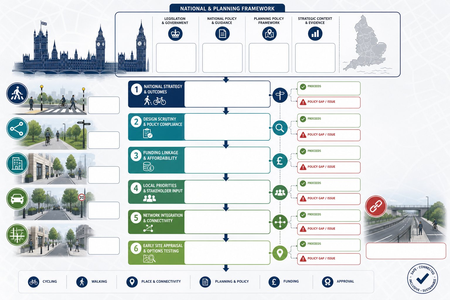
The policy backdrop has become much more demanding and much clearer. Across England, transport and planning policy increasingly expects walking and cycling to be integral to scheme design rather than treated as residual uses of leftover highway space.
At national level, the direction of travel is straightforward: make walking and cycling the natural choice for short journeys, support healthier communities, and reduce the environmental impact of transport. The Cycling and Walking Investment Strategy continues to shape funding priorities and local delivery expectations. At the same time, Active Travel England has changed the practical planning landscape by scrutinising certain schemes and linking design quality to both support and funding.
For applicants, that means the policy case cannot stop at broad statements about sustainability. We need to show how a proposal responds to actual standards, local priorities and likely authority concerns. A development may have excellent internal routes, but if those routes do not tie into the surrounding network or fail to address a known severance issue, officers may still see a policy gap.
This is why active travel should be tested early, at site appraisal and concept design stage, not patched in later once layouts are fixed. By then, the most important opportunities, direct connections, generous frontages, safer crossings, reduced vehicle dominance at key points, are often harder and more expensive to deliver.
National Guidance, Local Plan Policies, And Highway Authority Expectations
National guidance sets the broad design direction, but planning decisions are usually won or lost in the detail of local application. That means we have to read three layers together: national standards and guidance, development plan policy, and the practical expectations of the relevant highway authority.
Nationally, UK guidance increasingly emphasises routes that are safe, coherent, direct, comfortable and attractive for people of different ages and abilities. In practical terms, that affects width, segregation, crossing design, gradients, visibility, junction geometry and surface quality. It also pushes designers away from poor compromises such as awkward shared use beside fast traffic or indirect crossings that make walking and cycling the slowest option.
Locally, plans and supplementary guidance often go further. Many authorities now rely on Local Cycling and Walking Infrastructure Plans (LCWIPs) to identify priority corridors, strategic links, town centre improvements and future network gaps. If a site sits close to one of those corridors, the application should respond directly to it. Ignoring an LCWIP can look like ignoring adopted evidence.
Then there is the highway authority’s own review culture. Some authorities focus heavily on crossing safety, some on permeability through large sites, some on school access, and others on junction performance for cycles. We find that successful applications anticipate those priorities rather than waiting for consultation comments to reveal them.
What Counts As Effective Cycling And Walking Infrastructure
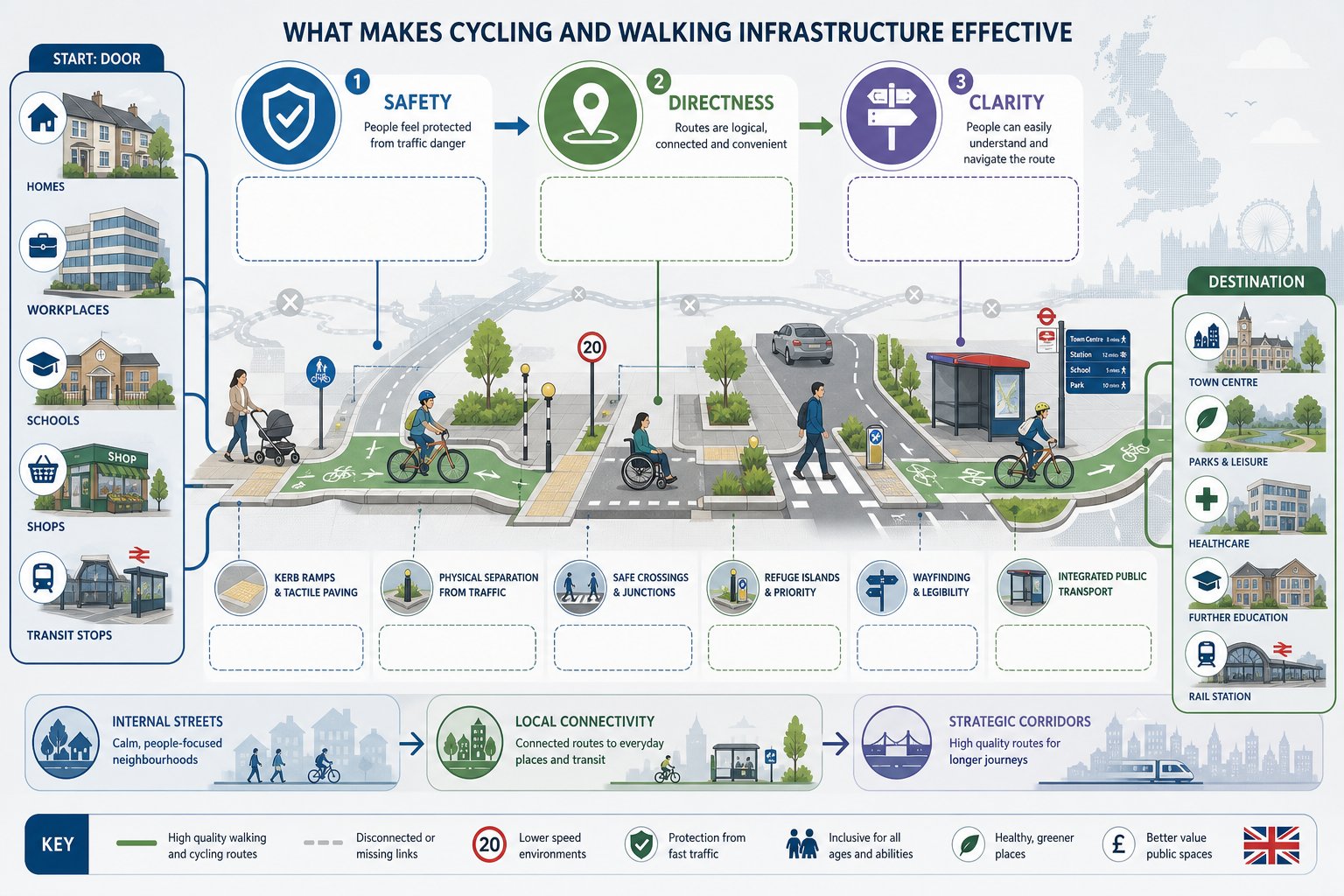
Effective cycling and walking infrastructure is not just infrastructure that exists. It is infrastructure that people will actually use because it feels safe, obvious and worthwhile.
That sounds simple, but poor schemes usually fail on one of those three tests. A route may be technically provided yet feel unsafe because it runs too close to fast traffic. It may be safe enough but so indirect that most people ignore it and walk along carriageways desire-line style. Or it may be direct but confusing, with inconsistent materials, missing signs, ambiguous priority and awkward crossing points.
In planning and development, effectiveness depends on how the whole journey works. Can someone leave a front door, employment building or retail unit and reach nearby destinations without needless detours? Can a parent walk with a pushchair comfortably? Can an older child cycle to school without mixing with heavy traffic at the worst junction? Can a wheelchair user pass without dropped kerbs that pool water or force repeated level changes? Those are the real-world questions officers, inspectors and consultees increasingly expect us to answer.
A strong scheme hence connects internal streets and paths to external routes, public transport stops, local facilities and wider strategic networks. It avoids isolated fragments. And it treats walking and cycling as normal everyday modes, not recreational afterthoughts. That distinction matters more than ever.
Core Design Principles For Safe, Direct, And Inclusive Routes
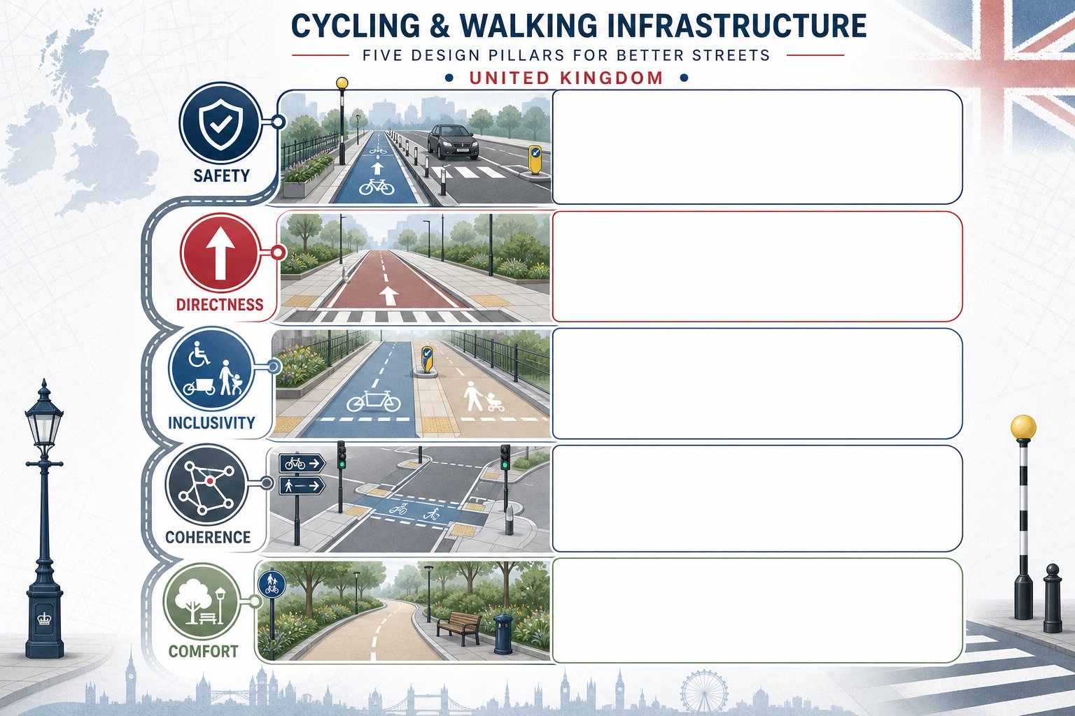
Good design principles are well established, but they need disciplined application.
Safety comes first. Where traffic speeds or volumes are high, separation is often necessary. That may mean protected cycle tracks, better side-road treatments, tighter junction geometry or lower-speed street design. Simply painting a lane beside fast-moving traffic rarely creates a comfortable environment for most users.
Directness is equally important. People usually choose the route that is quickest and easiest to understand. If cars get a straight line while pedestrians and cyclists are sent through dog-legs, staggered barriers or multi-stage crossings, the design is already telling us whose journey matters. Planning officers notice that.
Inclusivity means more than meeting a minimum width. Routes should account for mobility aids, non-standard cycles, child trailers, pushchairs, rest points, surfacing quality and manageable gradients. Crossing times and refuge widths matter too. So does lighting where routes are expected to serve regular daily trips.
Coherence and legibility tie the network together. Users should be able to follow a route naturally, with clear priority and consistent treatment. Sudden disappearances of cycle provision at junctions are a classic weak point.
And then there’s comfort. Smooth surfaces, reduced conflict, low delay and pleasant surroundings all influence whether active travel feels practical. Infrastructure does not need to be flashy, but it does need to work in ordinary weather, at ordinary times, for ordinary people.
Key Infrastructure Types Used In New Developments And Street Improvements
Most schemes use a mix of infrastructure types, and the right combination depends on context rather than fashion. Residential extensions, town centre upgrades, roadside redevelopment and employment sites all have different movement patterns and constraints.
The central point is that each element should support a complete route. A high-quality cycle track that ends at a hostile roundabout is only half a solution. A new footway that stops at the site boundary without a safe onward crossing leaves a gap exactly where objections tend to land.
For developments, internal street design is often just as important as off-site works. Low-speed, permeable layouts can enable walking and cycling naturally, reducing the need for more formal segregation in some areas. But on busier frontages and distributor roads, stronger protection and more deliberate crossing design are usually needed.
Specification also matters. Widths, kerb details, tactile paving, drainage, visibility, signing, turning radii, servicing arrangements and maintenance access can all affect whether infrastructure performs as intended. In our experience, planning submissions are stronger when drawings and transport evidence tell the same story: the proposed infrastructure is not only policy-compliant in principle, but workable in technical detail.
Footways, Shared Routes, Cycle Tracks, Crossings, And Junction Treatments
Footways remain fundamental. They should be continuous, appropriately wide, accessible and protected from obstruction. Narrow pavements squeezed beside carriageways or interrupted by excessive vehicle crossovers create exactly the sort of hostile environment that undermines a sustainability narrative.
Shared routes can work, but only in the right conditions: lower pedestrian and cycle flows, lower conflict potential, good visibility and clear space. They are often overused where separate provision would be better. If a shared path is proposed simply because there is not enough room for proper segregation, that usually deserves closer scrutiny.
Cycle tracks are increasingly expected on streets with higher traffic volumes or speeds. One-way or two-way arrangements can both be suitable, provided they connect logically and resolve priority clearly at side roads and access points. Kerb protection often improves comfort and uptake.
Crossings are where many schemes succeed or fail. Zebra, parallel and signal-controlled crossings all have a role, but the choice should follow route function and user need. Side-road entry treatments and continuous footway or cycleway treatments can dramatically improve priority and legibility if designed properly.
At junctions, protection matters. Protected junction layouts, cycle-friendly roundabouts, reduced corner radii and priority crossings can make the difference between theoretical access and realistic access. A route is only as good as its most stressful point.
How To Assess Existing Conditions Around A Site
A robust active travel assessment starts with honest observation. We need to understand how the area works today, where it fails, and what opportunities a development can realistically unlock.
That means going beyond desktop mapping. Site visits matter. So do audits at the times people actually travel: school drop-off, commuter peaks, evening periods, wet weather if possible. A route that looks adequate on a plan can feel entirely different when bins narrow the footway, parking overruns dropped kerbs or traffic speeds make an on-carriageway cycle connection feel unrealistic.
For pedestrians, we should review continuity, effective width, surfacing, lighting, gradients, crossing availability and personal security. For cycling, the key questions include traffic speed and volume, lane widths, existing cycle provision, pinch points, junction stress, parking conflict and whether less confident riders would reasonably use the route.
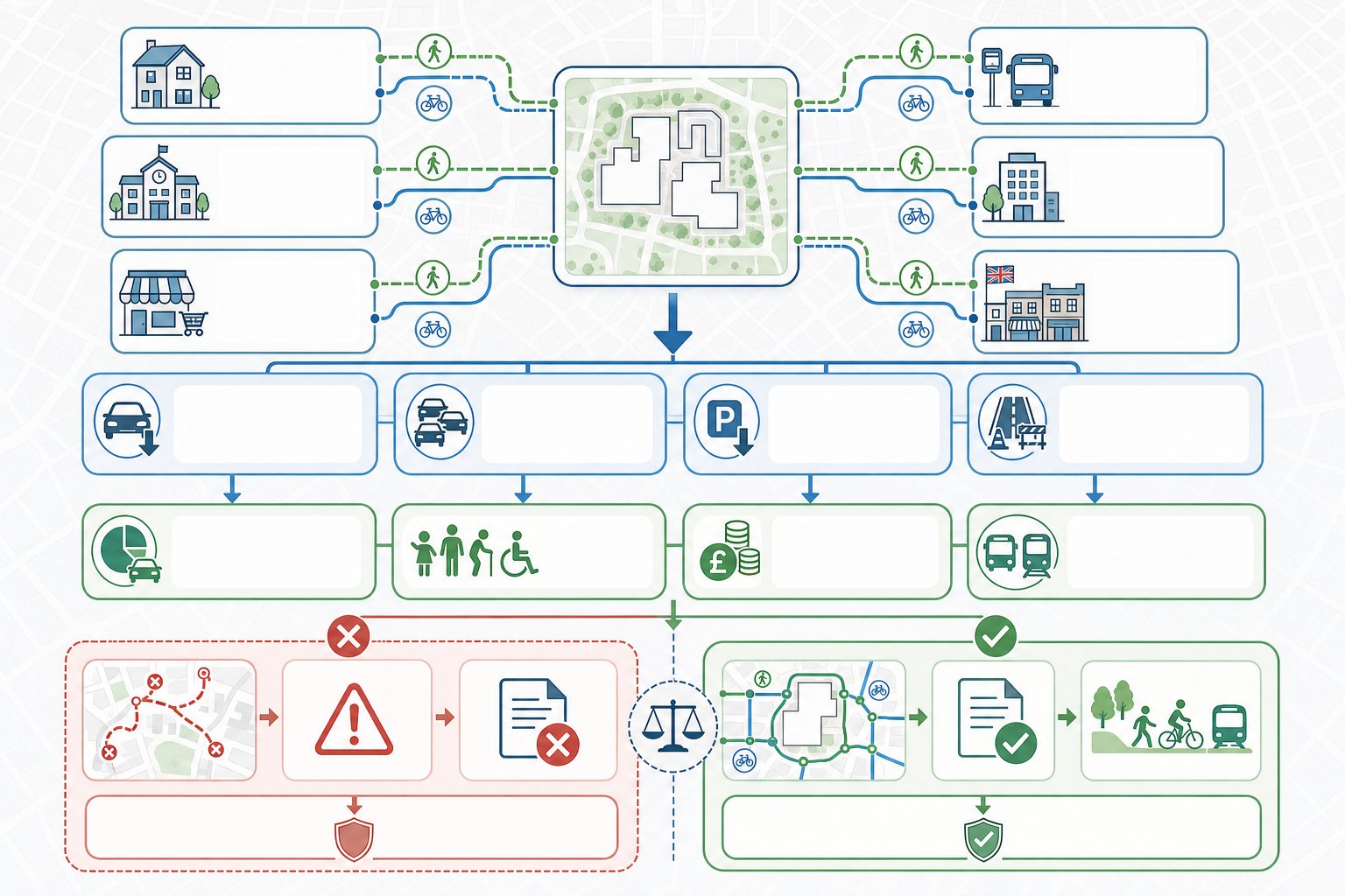
We also need to identify attractors: schools, local centres, healthcare, bus stops, rail stations, employment areas, parks and community facilities. If those destinations sit within realistic walking and cycling distance, the application should show how they can be reached safely and directly.
This assessment work often shapes the entire transport strategy. It informs trip assumptions, mitigation, off-site works, travel plan measures and the credibility of any claim that the development supports sustainable travel.
Connectivity, Accessibility, Desire Lines, And Network Gaps
Connectivity is about more than whether a line exists on a map. A connected network allows people to travel continuously between real origins and destinations without awkward breaks, unsafe crossings or confusing transitions.
We normally begin by mapping likely desire lines. Where will residents walk to buy milk? Which route will staff use to reach the nearest bus stop? Where are pupils likely to cycle? People do not move according to neat red lines on planning diagrams: they follow the simplest sensible route. Good design responds to that human instinct rather than trying to fight it.
Accessibility then tests whether those routes are usable by a broad range of people. Are gradients reasonable? Are dropped kerbs aligned? Is there enough width for side-by-side movement or passing? Can a non-standard cycle navigate barriers and corners? The answer must be practical, not theoretical.
Finally, we identify network gaps. These may be short but critical: a missing dropped kerb, no crossing near a desire line, a narrow bridge, an intimidating roundabout, a severed footway, a dead-end path. LCWIPs and local plans are useful here because they often highlight strategic deficiencies already recognised by the authority. If a development can help plug one of those gaps, the planning case becomes much stronger.
Sometimes the most valuable intervention is not inside the red line at all, but just beyond it.
Integrating Active Travel Into Transport Assessments And Travel Plans
If active travel is important to the design, it should also be visible throughout the evidence base. Too many transport assessments mention walking and cycling positively in the opening chapters, then quietly revert to a car-focused analysis everywhere else.
A better approach is to thread active travel through the whole submission. Existing conditions should include route audits and network mapping. Accessibility should be demonstrated to key destinations by walking and cycling time, not just by drive-time. Trip generation and mode share assumptions should reflect local and national policy aspirations where justified by site context and infrastructure quality. Proposed mitigation should explain how internal layout and off-site works support safer, more attractive active trips.
Travel plans are equally important. Secure and convenient cycle parking, changing facilities where relevant, wayfinding, welcome packs, personalised travel information, cycle training links, public transport integration, monitoring and review mechanisms all help turn infrastructure into actual behaviour change. But they only work if the underlying routes are credible.
For planning teams, this joined-up approach is often what gives an application resilience. It shows that active travel has been considered from first principles rather than inserted to satisfy a checklist. That is a big difference. And in practice, concise, locally tuned reporting can make that difference clearer for officers and consultees reviewing multiple complex documents under time pressure.
Common Design And Planning Mistakes That Lead To Objections
Some objections are highly site-specific. Others are painfully predictable.
One common mistake is providing short, disconnected pieces of infrastructure that look positive on a plan but fail as a usable route. Another is forcing pedestrians and cyclists into indirect, delayed movements while preserving vehicle priority at every key junction. If walking and cycling are supposedly encouraged, the geometry should show it.
Sub-standard widths also cause problems, particularly where designers rely on nominal dimensions without considering walls, columns, overhang, street furniture, drainage features or passing space. The same goes for poor surfacing, steep ramps, awkward tactile layouts and routes vulnerable to obstruction from parking, loading or refuse storage.
Shared use is another regular weak point. It is often proposed as an easy compromise, yet in constrained or busy settings it can simply transfer conflict from vehicles to vulnerable users. Authorities are increasingly alert to that.
Perhaps the biggest strategic error is ignoring the wider network. Applications that fail to engage with LCWIPs, local plan priorities or known severance issues can appear detached from adopted policy evidence. That is avoidable.
In our experience, objections are less likely when the submission explains not only what is proposed, but why it is the right response to the site, the surrounding network and the authority’s policy framework. That extra layer of reasoning matters.
Conclusion
In 2026, good cycling and walking infrastructure is not a fringe design issue. It is a planning issue, a transport issue and, increasingly, a viability issue. The strongest schemes are the ones that start with movement patterns people will actually follow and then design safe, direct and inclusive routes around them.
For developers, consultants and local authorities, the message is fairly plain: active travel needs to be embedded early, tested honestly and evidenced clearly. That means understanding local policy, LCWIPs and highway authority expectations: auditing existing conditions properly: and making sure transport assessments and travel plans support the same story as the drawings.
Done well, this is not just about avoiding objections. It helps create places that are easier to access, healthier to live in and more resilient in policy terms. And when applications need concise, technically robust transport input shaped around those realities, that is exactly the kind of work we focus on at ML Traffic.
Cycling and Walking Infrastructure FAQs
Why is cycling and walking infrastructure crucial in planning applications?
Cycling and walking infrastructure reduces car dependency, lowers congestion and emissions, and supports inclusive access to jobs, education, and services. It is a core planning test ensuring developments are accessible, sustainable, and aligned with national and local policies.
How do national policy and local plans influence active travel infrastructure requirements?
National policies aim to make walking and cycling the natural choice for short journeys, guided by the Cycling and Walking Investment Strategy and Active Travel England standards. Local plans and LCWIPs identify priority routes and expect developments to provide safe, direct, and connected active travel infrastructure.
What are the key design principles for effective cycling and walking infrastructure?
Effective infrastructure prioritises safety through separation from fast traffic, direct and legible routes following desire lines, inclusivity with accessible gradients and widths, minimal junction delay, coherence, and comfort with smooth surfaces and pleasant surroundings suitable for all ages and abilities.
What types of infrastructure are typically used to support active travel in new developments?
Common infrastructure includes continuous footways separated from roads, shared routes where appropriate, protected cycle tracks (one-way or two-way), safe crossings (zebra, signal-controlled), and junction treatments like cycle-friendly roundabouts and protected side-road crossings, all integrated into connected networks.
How can planning applicants ensure their transport assessments and travel plans support active travel goals?
Applicants should demonstrate walking and cycling connectivity to key destinations, align trip generation and mode share with policy aspirations, include infrastructure details, and complement with travel plans offering secure cycle parking, wayfinding, personalised travel info, and monitoring to encourage mode shift to active travel.
What are common mistakes in cycling and walking infrastructure design that lead to planning objections?
Frequent issues include disconnected or short routes, indirect crossings favouring cars, sub-standard widths, poor surface quality, routes blocked by parking or servicing, overuse of shared paths in unsuitable locations, and failure to connect with adopted local networks or LCWIPs, all weakening policy compliance and user safety.