If a planning application lives or dies on access, movement, and network impact, then highway infrastructure design UK work is rarely a side note. It’s often the point where planning ambition meets engineering reality.
For architects, planners, developers, solicitors, surveyors, and local authorities, that reality is getting more demanding in 2026. Highway design now has to do more than fit kerbs, radii, and visibility splays onto a drawing. It must respond to national policy, local transport strategy, climate resilience, inclusive movement, technical approval routes, and increasingly tight scrutiny from highway authorities and consultees. A scheme can look straightforward on paper, then stall because drainage was treated too late, junction capacity was under-tested, or the access strategy wasn’t aligned with the local authority’s design guide.
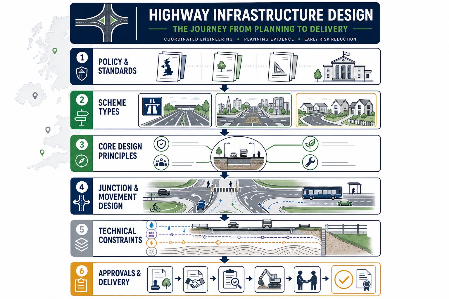
In practice, good highway infrastructure design in the UK is about joining up planning, transport evidence, and detailed engineering early enough to avoid expensive redesign. That means understanding what type of scheme you’re promoting, which standards actually apply, how the authority will review it, and what drawings and assessments need to accompany the planning case.
In this guide, we set out the core principles, approval pathways, and recurring pitfalls that shape successful project delivery across UK highway schemes, from development-led access works to wider highway improvements and adoptable estate roads.
What Highway Infrastructure Design Covers In The UK Planning Context
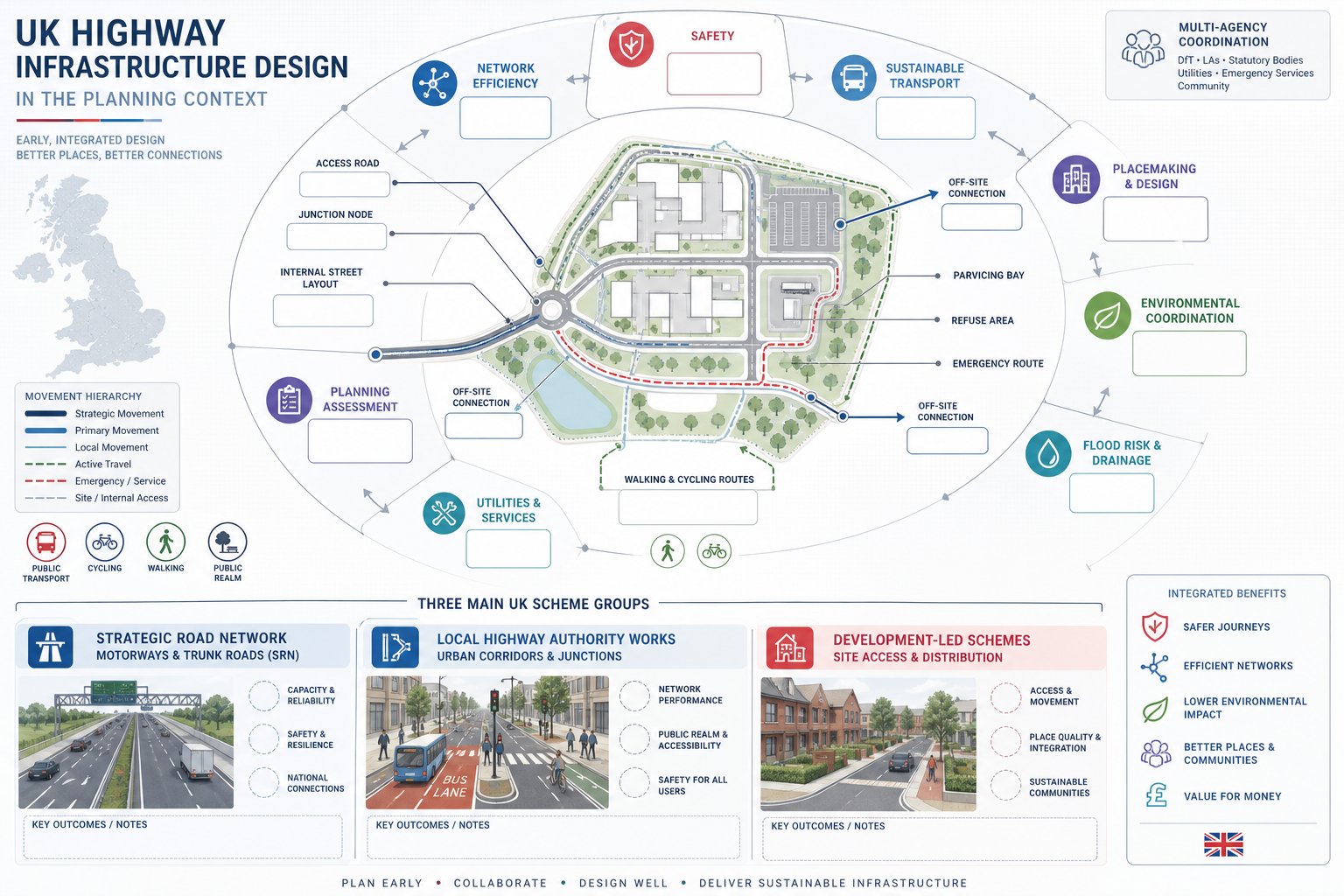
Highway infrastructure design in the UK planning system covers far more than the carriageway edge. In planning terms, it usually includes site access, junction alterations, internal road layouts, walking and cycling links, servicing strategy, car parking arrangement, refuse and emergency access, and any off-site works needed to make a development acceptable.
For development-led projects, the design must show that the proposal can be safely reached, can operate efficiently, and won’t create severe impacts on the surrounding network. That often links directly to the policy tests behind Transport Assessments, Transport Statements, and planning conditions. For larger schemes, it also has to sit alongside environmental work, flood risk strategy, utilities planning, and sometimes Environmental Impact Assessment.
The planning context matters because the highway solution is rarely judged in isolation. Authorities will look at whether it supports local plan objectives, sustainable transport priorities, road safety outcomes, and placemaking goals. A technically workable junction may still be challenged if it undermines walking routes, public realm quality, or bus access.
That’s why we usually advise treating highway design as part of the planning narrative from day one, not as a late-stage engineering add-on. When the access strategy, movement hierarchy, and technical constraints are understood early, the application tends to move faster and with fewer painful revisions.
The Main Types Of Highway Infrastructure Schemes
In broad terms, UK schemes tend to fall into three groups.
First, there are Strategic Road Network projects involving motorways and trunk roads, where National Highways standards, approvals, and operational concerns are central. These are typically the most procedurally demanding.
Second, there are local highway authority schemes: junction upgrades, corridor improvements, traffic management changes, bus priority measures, and public realm interventions on county, city, or borough roads.
Third, there are development-led schemes. These are the projects many planning teams deal with most often: new priority or signalised junctions, ghost islands, roundabout modifications, internal estate roads, adoptable streets, servicing yards, parking courts, and pedestrian/cycle links tied to housing, commercial, logistics, education, or mixed-use development.
Some schemes, of course, blur the edges. A housing site may require both local road works and interventions affecting the Strategic Road Network. And that’s exactly where early scoping pays off.
How Policy, Standards, And Local Authority Requirements Shape Design
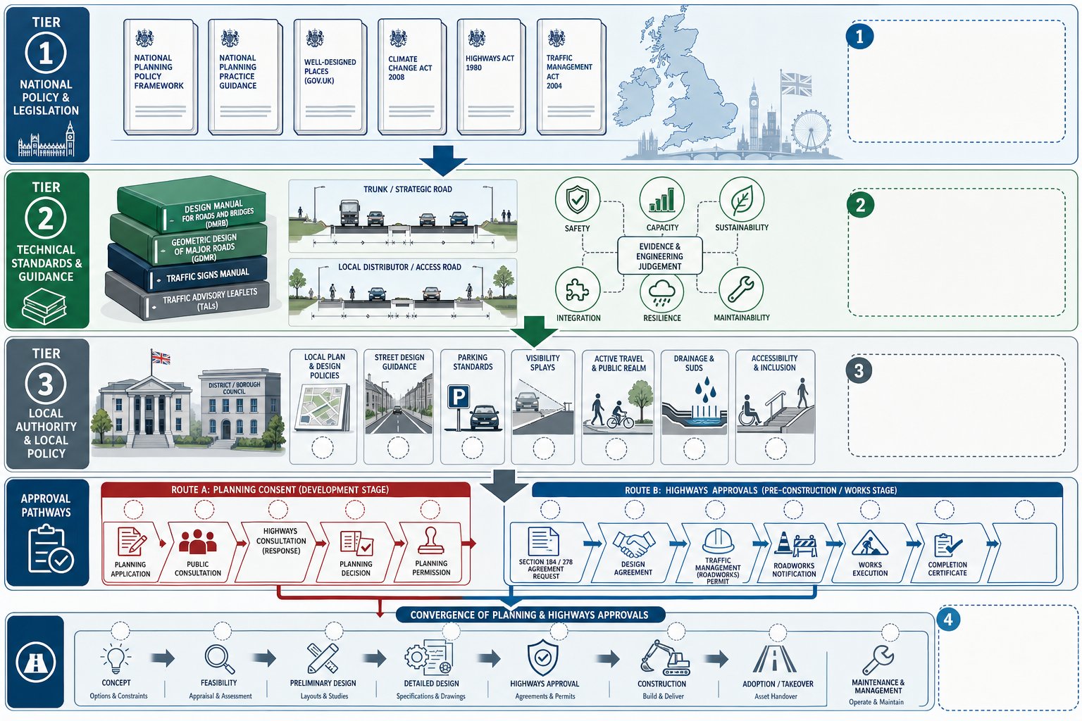
Every highway design decision sits inside a policy and standards framework. The trick is knowing which documents are genuinely determinative, which are advisory, and which local requirements will shape the authority’s expectations in practice.
At national level, relevant policy can include the National Planning Policy Framework, transport decarbonisation objectives, and, for nationally significant infrastructure, National Policy Statements and the Planning Act regime. On the technical side, National Highways’ DMRB remains the core reference point for the Strategic Road Network and often influences wider practice, even where it does not apply directly.
But many planning disputes happen at local level. Local Plans, Local Transport Plans, area action policies, parking standards, highways supplementary planning documents, and street design guides can be just as important as national guidance. One authority may support tighter urban geometry and place-led design: another may be more conservative on visibility, tracking, or adoptable street width. Designers who ignore that local culture usually discover it during consultation, which is the expensive moment to learn it.
For firms like ours, working across authorities means tailoring reports and drawings to local thresholds and approval habits, not just citing generic standards. That sounds obvious, but it’s often the difference between a smooth technical review and three rounds of avoidable comments.
National Guidance, Design Codes, And Approval Routes
The main guidance stack usually includes DMRB for trunk roads and motorway-related matters, Manual for Streets principles for lower-speed local environments where adopted or accepted, local street design manuals, and specialist guidance on active travel, drainage, and accessibility. National Highways’ design principles, including the emphasis on good design rather than purely engineered minimums, also shape expectations around context-sensitive solutions.
Approval routes depend on scheme type. Nationally Significant Infrastructure Projects typically proceed through the Development Consent Order process under the Planning Act 2008. More routine development generally sits under the Town and Country Planning Act, often with parallel or subsequent processes under the Highways Act 1980 for off-site works, stopping up, Section 278 works, Section 38 adoption, or other agreements.
That overlap matters. A planning permission may establish the principle of access, but detailed technical approval for construction or adoption often comes later. If the concept design has not been developed with those later stages in mind, delays are almost guaranteed.
Key Design Principles For Safe, Efficient, And Buildable Highway Layouts
The best highway layouts tend to look deceptively simple. Behind that simplicity is a balancing exercise between safety, capacity, usability, construction cost, maintainability, and long-term resilience.
Safety is the baseline, but it is not the only design objective. A layout also needs to function operationally across typical and stressed conditions, accommodate the right vehicles, allow intuitive movement, and be capable of being built without heroic retaining structures or endless utility diversions. We also need to think about maintenance access, drainage performance, future resurfacing, and how the network behaves in heavy rainfall or during incidents.
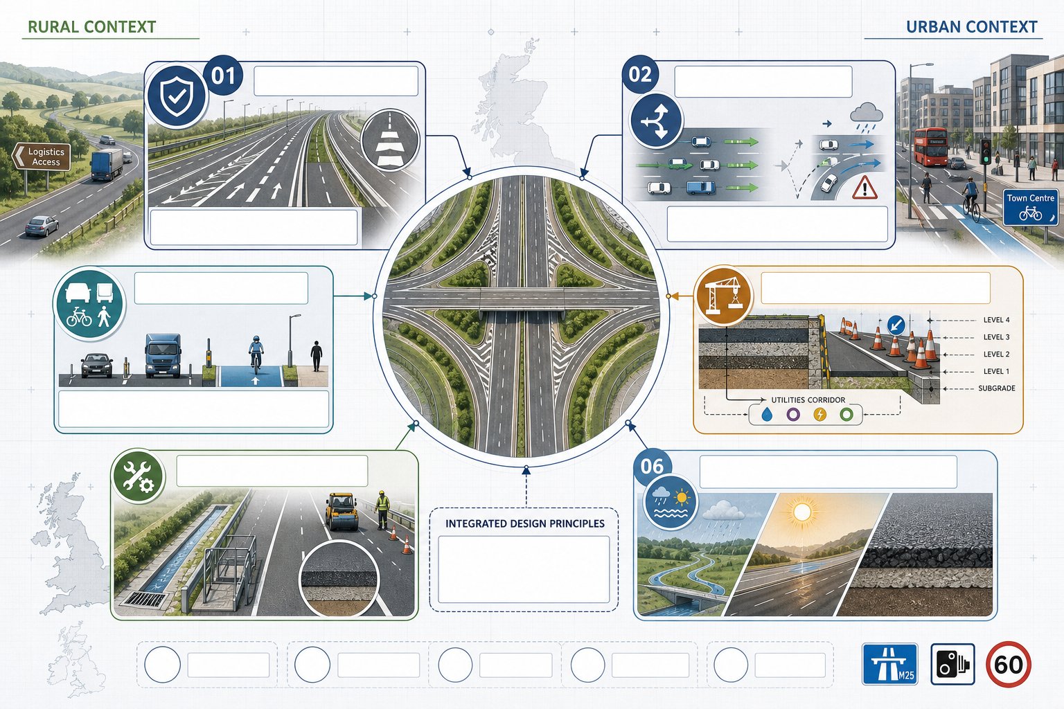
Context matters enormously. A rural access junction serving a logistics site has different priorities from an urban mixed-use street where pedestrian comfort and cycle permeability are front and centre. Good design responds to place, speed environment, land use, and likely user behaviour rather than applying geometry mechanically.
Buildability is another area that gets underestimated. A neat preliminary drawing can unravel once levels, tie-ins, statutory undertakers’ apparatus, retaining requirements, and temporary traffic management are understood. So practical design means asking awkward questions early: can we actually construct this within the land available, maintain traffic, drain it properly, and hand it over for adoption?
In 2026, climate resilience is no longer a nice extra either. Heat, intense rainfall, flood pathways, and maintenance burdens increasingly shape pavement choice, drainage strategy, and materials specification. In short, good highway infrastructure design UK work is not just compliant. It is workable, durable, and proportionate.
Junction Design, Access Strategy, And Network Capacity Considerations
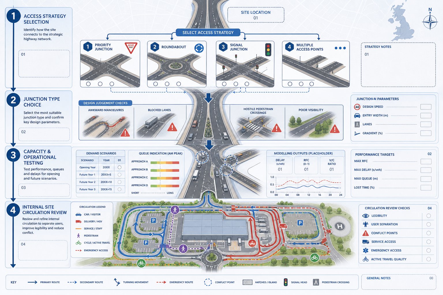
Junction design is usually where transport planning evidence and engineering detail meet most visibly. The chosen form of access has to be safe, legible, policy-compliant, and capable of handling expected traffic without creating unacceptable queues or blocking effects.
That starts with the access strategy itself. Should the development connect via a simple priority junction, a compact roundabout, signals, or multiple access points separating cars, service vehicles, and active travel users? The answer depends on traffic generation, road hierarchy, frontage constraints, speed environment, nearby junction spacing, right-turn demand, pedestrian flows, and the authority’s appetite for intervention.
Once a junction form is identified, capacity and operational testing usually follow. That may involve priority junction assessment, roundabout modelling, signal modelling, network simulation, queue analysis, and sensitivity testing for future year scenarios. The purpose is not just to prove theoretical capacity. It is to show that the proposed arrangement protects network performance and does not introduce knock-on problems nearby.
There is also a design judgement element that software alone cannot resolve. A model may say a layout operates within capacity, but if turning paths are awkward, pedestrian crossings feel hostile, or deliveries block the only lane, the real-world result can still be poor.
And then there is access hierarchy within the site. Internal roads, servicing loops, parking areas, and emergency access need to reinforce efficient circulation rather than create conflict. A successful access strategy feels obvious to users. When drivers hesitate, overshoot, reverse awkwardly, or compete for space with pedestrians, the layout is usually telling us something.
Walking, Cycling, Public Transport, And Inclusive Movement Requirements
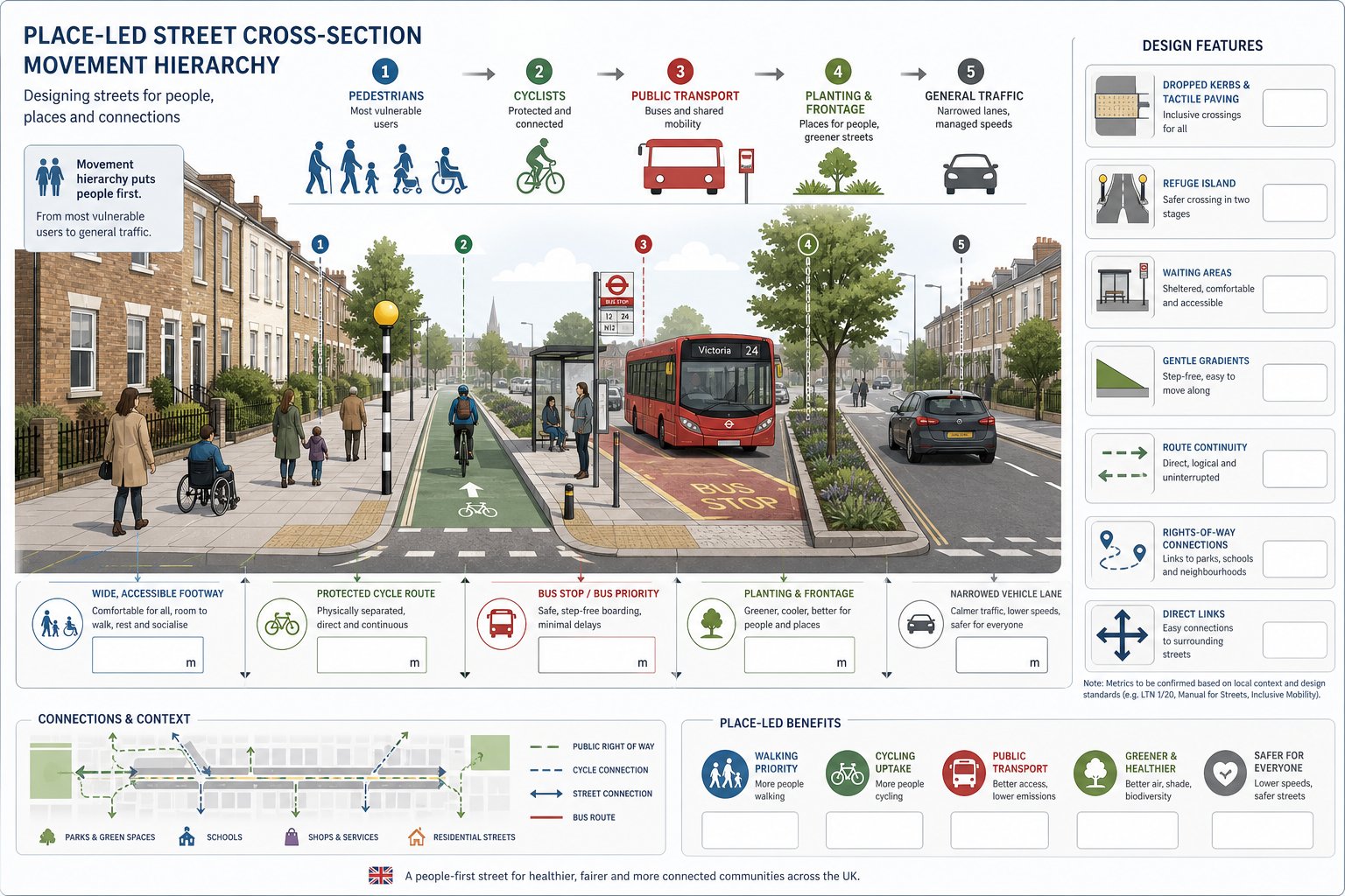
Highway design for planning applications is no longer judged mainly on car movement, if it ever really should have been. Authorities increasingly expect schemes to prioritise sustainable and inclusive movement from the outset.
That means safe, direct, and attractive walking routes: coherent cycle access: suitable crossing facilities: connections to existing rights of way or local desire lines: and, where relevant, infrastructure that supports bus penetration, bus stop upgrades, or priority measures. For many authorities, these are not bolt-ons to help a planning statement read better. They are core tests of whether the development is genuinely accessible.
Inclusive design broadens the conversation further. Kerb details, gradient, crossfall, tactile provision, dropped crossings, refuge width, waiting areas, and route continuity all affect whether older people, disabled users, parents with pushchairs, and less confident cyclists can use the scheme comfortably. A route that technically exists but feels awkward, indirect, or unsafe is unlikely to achieve its purpose.
The key is movement hierarchy. We need to ask who the street is for first, and only then decide how geometry, frontage, planting, parking, and crossing points support that hierarchy. In lower-speed development settings, that often means a place-led street design rather than a highway-first layout.
From a planning perspective, these choices also support Travel Plans and mode share assumptions. If a development claims sustainable trip patterns but provides poor walking and cycling links, decision-makers will notice the mismatch rather quickly.
Drainage, Utilities, Levels, And Other Technical Constraints
Some of the biggest design delays come from issues that are barely visible on early concept drawings. Drainage, utilities, levels, and ground conditions have a habit of doing that.
Highway drainage must deal with runoff safely and within the receiving system’s limits. Increasingly, schemes are expected to integrate sustainable drainage principles, attenuation, treatment stages, exceedance routes, and climate allowances rather than simply pipe water away. The highway layout affects all of that: kerb lines, gradients, low points, crossing locations, and available verge space all influence whether the drainage solution is realistic.
Utilities are another classic constraint. Existing apparatus can dictate carriageway width, restrict tree planting, complicate drainage runs, or make a seemingly modest widening prohibitively expensive. Early statutory undertaker searches and coordination are worth their weight in gold.
Levels and earthworks matter just as much. Tying a site access into an existing road, achieving workable gradients, avoiding excessive retaining walls, and coordinating finished floor levels with drainage and visibility can become a complex three-dimensional exercise. On sloping or constrained sites, this often drives the design more than plan geometry does.
Then there are structures, geotechnical considerations, pavement design, and construction phasing. Each can affect cost, programme, and adoptability. The lesson is simple: technical constraints should inform concept design, not arrive later as reasons why the concept no longer works.
Road Safety, Visibility, Speed Environment, And Audit Requirements
Road safety is threaded through every stage of highway design, but it becomes especially visible in discussions around access geometry, visibility, crossing provision, speed environment, and Road Safety Audit.
Visibility splays remain a recurring source of planning negotiation. The correct approach depends on road type, actual vehicle speeds, alignment, vertical profile, and the standard or guidance being applied. Designers need to be realistic about achievable visibility within land control and honest about whether mitigation is needed, whether through speed management, vegetation control, relocation of access, or a different junction form.
Speed environment is broader than posted speed limit. We need to consider what speeds drivers are likely to travel at, how the road reads visually, and whether the proposed layout encourages behaviour consistent with the intended function. A 30 mph sign does not automatically create a 30 mph environment. Geometry, frontage activity, crossing frequency, and carriageway character all play a part.
Formal Road Safety Audits are generally undertaken at key stages and should be treated as a valuable challenge process, not an irritating box-tick. A good audit can spot conflict points, non-motorised user issues, maintenance hazards, or driver expectancy problems before they become built-in defects.
That said, an audit is not a substitute for sound design judgement. If a layout is fundamentally strained, the audit will not rescue it. Better to resolve safety issues at concept stage than to defend them later under pressure from consultees, members, or, worse, after opening.
How Highway Infrastructure Design Supports Planning Applications
In planning terms, highway design is evidence. It demonstrates that the development can be accessed safely, integrated with the surrounding network, and mitigated where necessary. Without credible design work, transport statements tend to read as aspiration rather than proof.
A robust design package helps planning officers and highway consultees answer practical questions quickly. Where is the access? Can refuse vehicles turn? Are visibility splays available within control? Will the junction accommodate forecast demand? How do pedestrians reach nearby services? Can off-site works be delivered within highway land or third-party land constraints? Is there a workable route to adoption?
This is where coordinated reporting matters. Plans, swept path drawings, preliminary engineering layouts, and transport evidence should tell the same story. If the highway drawing shows one thing and the Transport Assessment assumes another, confidence in the whole application drops.
For many schemes, concise and authority-specific technical submissions are more persuasive than bloated generic reports. That is very much the approach we value at ML Traffic: clear transport engineering reports, prepared quickly, but shaped around the local authority’s thresholds, policy context, and review habits. Speed helps, of course. Accuracy and relevance help more.
Transport Assessments, Travel Plans, And Supporting Technical Evidence
Depending on scale and impact, the supporting package may include a Transport Assessment, Transport Statement, Framework or Full Travel Plan, junction capacity modelling, swept path analysis, speed surveys, collision review, access drawings, parking plans, delivery and servicing analysis, and construction traffic material.
Each piece should support a clear planning argument. The Transport Assessment explains baseline conditions, trip generation, distribution, assignment, impact, and mitigation. Travel Plans set out how sustainable travel will be encouraged and monitored. Design drawings show the physical solution is deliverable. Technical appendices give consultees confidence that assumptions have been tested rather than guessed.
The strongest submissions are proportionate. A small infill scheme does not need a strategic modelling epic. But a major allocation site cannot rely on a simplistic access sketch and broad promises. Matching evidence to impact is part of good planning strategy.
From Concept To Delivery: Design Stages, Approvals, And Adoption
Highway schemes usually move through concept, preliminary, and detailed design before construction, but the important point is not the labels. It is the increasing level of commitment and scrutiny at each stage.
Concept design tests feasibility: access options, land take, constraints, broad geometry, movement hierarchy, and planning fit. Preliminary design develops that into something capable of supporting planning, cost estimation, and consultation. Detailed design resolves construction information, specification, drainage details, pavement build-up, signs and lines, utilities interface, and technical approval requirements.
Approvals may run in parallel or sequence. Planning permission may establish the principle of development and associated access works. Separate agreements or approvals may then be needed for work in existing highway, new adoptable roads, structures, drainage outfalls, traffic regulation orders, or works affecting the Strategic Road Network.
Adoption is another area where early decisions matter. If roads are intended for adoption under Section 38, the authority’s specification, geometry standards, drainage expectations, lighting requirements, and commuted sums approach can shape the layout from the start. Retrofitting adoptability later is usually awkward and expensive.
Construction and handover complete the picture. Temporary traffic management, phasing, quality control, as-built information, and maintenance responsibilities all need planning well before boots hit site. The schemes that deliver most smoothly are usually the ones where planning, engineering, and legal processes were aligned early rather than managed in silos.
Common Design Challenges And How To Avoid Delays
Most highway design delays are predictable. They tend to arise not from obscure technical surprises, but from ordinary issues left too late.
One common problem is late engagement with the highway authority or National Highways. Designers make reasonable assumptions, progress the scheme, and then discover a local policy nuance, modelling requirement, or adoption expectation that changes everything. Early dialogue is almost always cheaper than redesign.
Another is weak baseline data. Out-of-date traffic surveys, poor speed data, limited collision review, or sketchy topographical information can undermine otherwise competent design work. If the starting point is wrong, every later conclusion becomes harder to defend.
Coordination failures are just as damaging. Highway geometry may look fine until flood risk consultants, landscape architects, utilities teams, and masterplanners reveal conflicting assumptions. We have seen accesses shifted by retaining needs, cycle routes squeezed by service corridors, and drainage features land exactly where visibility needs to be kept clear. None of that is unusual. It just needs integrating early.
A final challenge is narrative. Even a technically sound scheme can stall if the application does not explain why the chosen design is appropriate, proportionate, and policy-led. Decision-makers need a coherent story, not just separate drawings and calculations.
The practical fix is straightforward: engage early, survey properly, test options honestly, coordinate disciplines, and produce evidence that fits the authority reviewing it. Do that, and highway infrastructure design UK work becomes far more predictable.
Highway design is rarely the easiest part of a planning application, but it is often one of the most influential. Done well, it reduces objection risk, supports a stronger planning case, and creates infrastructure that can actually be delivered, adopted, and used safely. In 2026, that means designing with policy, people, and technical reality in view at the same time.
For architects, planners, developers, and councils, the winning approach is practical rather than flashy: establish the right standards early, understand local authority expectations, coordinate drainage and utility constraints before layouts harden, and make sure transport evidence and engineering drawings say the same thing.
That’s the real value of good highway infrastructure design in the UK. It turns an access idea into a consentable, buildable, defensible scheme, and saves a lot of pain along the way.
Frequently Asked Questions on Highway Infrastructure Design in the UK
What does highway infrastructure design include in the UK planning system?
In the UK, highway infrastructure design covers site access, junction alterations, internal road layouts, walking and cycling links, servicing strategies, car parking arrangements, refuse and emergency access, plus any off-site works needed to support a development’s safe and efficient operation within planning policies.
How do national and local policies influence highway infrastructure design in the UK?
Design must comply with national frameworks like the National Planning Policy Framework and standards such as National Highways’ DMRB, while also aligning with local plans, transport strategies, street design guides, and parking standards, which shape authority expectations and practical approvals.
What are the main types of highway infrastructure schemes in the UK?
UK schemes typically include Strategic Road Network projects involving motorways and trunk roads, local highway authority schemes like junction upgrades and bus priority, and development-led schemes such as housing estate roads, priority junctions, and pedestrian/cycle links associated with new developments.
Why is early coordination between planning, transport evidence, and highway engineering important?
Early integration avoids costly redesign by ensuring that access strategies and technical constraints are aligned with local authority requirements and design guides, leading to smoother planning approval and construction phases with fewer revisions or objections.
How are walking, cycling, and inclusive movement addressed in UK highway design?
Highway design prioritises safe, direct, and attractive pedestrian and cycle routes, accessible crossings, and bus infrastructure, ensuring inclusive access for disabled users, older people, and families, in line with sustainable transport policies and travel plan commitments.
What common challenges cause delays in highway infrastructure design projects and how can they be avoided?
Delays often stem from late engagement with authorities, insufficient baseline data, poor coordination of utilities and drainage, and unclear design rationale. Early stakeholder communication, thorough surveys, integrated multidisciplinary design, and clear, proportionate reporting help prevent these issues.