Planning authorities are asking tougher questions. Not just whether a site can be accessed, but whether a scheme will work over time, support policy objectives, reduce transport impacts, and help create a place people can actually live in well. That is where a well-structured masterplan transport strategy becomes essential.
For architects, planners, developers, legal teams and local authorities, the challenge is rarely just technical modelling in isolation. It is joining up land use, movement, infrastructure, phasing and policy into one planning-ready narrative. If that chain is weak, even a promising development can stall in pre-app, attract extensive objections, or end up burdened with avoidable redesign and delay.
In our experience, the strongest strategies do two things at once. They satisfy the evidence requirements behind planning applications, local plan promotions and hybrid schemes, while also setting a realistic long-term framework for delivery. That means understanding existing conditions, forecasting demand properly, prioritising sustainable travel, and proving that infrastructure can be phased and funded.
This guide explains how to build that framework in 2026. We will look at what a masterplan transport strategy is, what it needs to achieve, how its evidence base should be assembled, and how a multi-modal movement plan can be tested for deliverability. The aim is simple: a strategy that is robust enough for planners, practical enough for delivery teams, and clear enough to support confident decision-making.
What A Masterplan Transport Strategy Is And Why It Matters
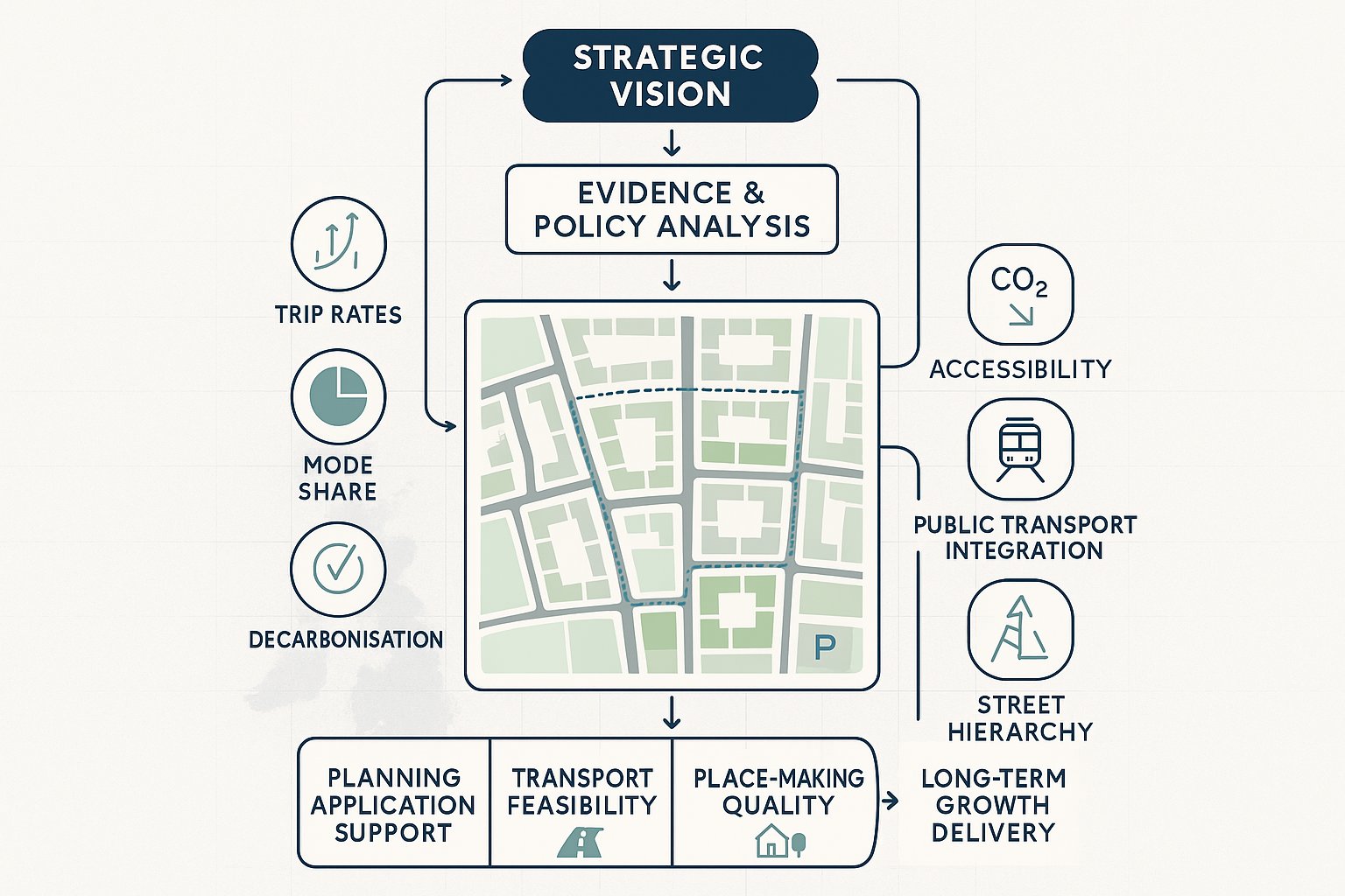
A masterplan transport strategy is a long-term, evidence-led framework showing how people and goods will move to, from and within a site or wider growth area. It sits above the narrow scope of a single junction drawing or standalone transport statement. Instead, it links movement with land use, design, infrastructure investment and delivery over the life of a development.
That distinction matters. Major schemes are rarely assessed on immediate highway effects alone now. Decision-makers want to know whether the proposal aligns with local and regional transport ambitions, whether it supports decarbonisation, whether it improves accessibility, and whether the transport approach is realistic at each stage of build-out.
A strong strategy gives that structure. It translates policy into measurable assumptions about trip rates, mode share, parking, street hierarchy, public transport integration and mitigation. It also helps project teams speak the same language early. Architects can test block layout against movement corridors. Planners can tie mobility principles to policy. Developers can understand what infrastructure is likely to be needed, when, and why.
For planning applications, it becomes the backbone behind transport assessments, travel plans and delivery schedules. For local authorities and promoters, it helps show that growth is not just aspirational but transport-feasible.
How It Supports Planning Applications And Long-Term Place Making
At application stage, the strategy provides a clear audit trail. It shows how assumptions were reached, what evidence has been considered, and how the transport solution responds to site context rather than relying on generic mitigation. That is often crucial when dealing with outline applications, parameter plans, allocation sites or phased developments where exact details will evolve.
Just as importantly, it supports place-making. A development that simply accommodates vehicle access is not necessarily a successful place. We need to think about whether residents can walk to schools safely, whether bus services can operate efficiently, whether cycle routes are coherent, and whether servicing arrangements undermine public realm.
In practice, the transport strategy helps shape the masterplan itself. It influences frontage design, density, parking distribution, junction form, bus routing and the quality of streets and spaces. Done properly, it avoids the common trap of designing the place first and trying to “fit” transport later.
For firms like ours at ML Traffic, this is often where value is created early: producing concise, authority-aware transport evidence that supports consent while keeping the wider vision deliverable over the long term.
The Core Objectives Of A Strong Transport Strategy
Every credible transport strategy needs clear objectives. Without them, the work becomes a collection of drawings, traffic figures and aspirations that do not quite connect. Objectives provide the logic for later decisions on access, modelling, mitigation and phasing.
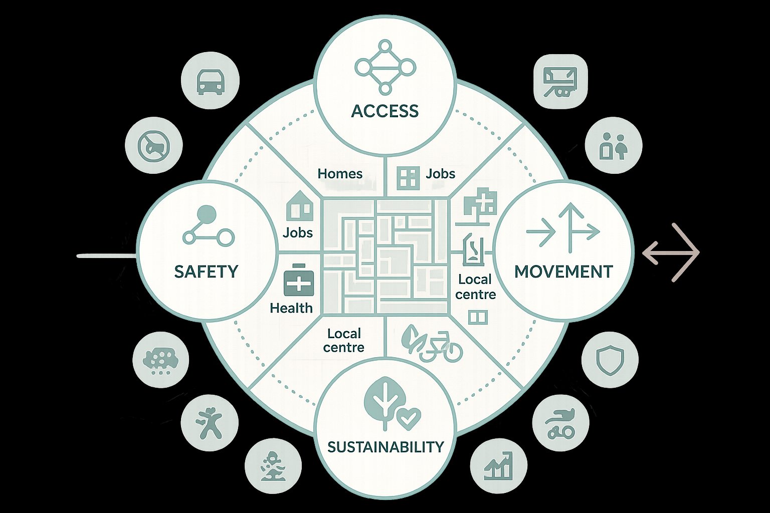
In 2026, those objectives normally extend well beyond traffic capacity. A planning-ready framework should support sustainable growth, improve access to homes, jobs and services, reduce environmental harm, and create a network that is safe and resilient. Economic performance matters, yes, but so do inclusion, public health, air quality and the quality of place.
That means we should be asking broader questions from the outset. Will the development enable a realistic shift away from car dependence? Does the proposed layout reduce severance or reinforce it? Are the most vulnerable users properly considered? Can freight and servicing be handled without undermining streets intended for people?
The best strategies set out a concise hierarchy of aims and then carry those through every technical choice. For example, if reducing car mode share is a stated objective, parking levels, bus accessibility, walking links and modelling assumptions all need to reflect that. If safety is central, design speeds, crossing provision and street geometry cannot be treated as an afterthought.
Good transport strategy is disciplined in that sense. The objectives are not decorative. They become the test against which each component of the masterplan is judged.
Balancing Access, Movement, Safety, And Sustainability
This is where many schemes become difficult, because the objectives can pull in different directions. We want access, but not at the cost of excessive traffic intrusion. We want efficient movement, but not if it creates hostile streets. We want development viability, but not by locking in poor sustainability outcomes for decades.
Balancing those tensions requires a place-led approach. Access should begin with the needs of people reaching key destinations such as homes, employment areas, schools, healthcare and local centres. Movement should then be organised in a way that supports that access without encouraging unnecessary car trips through the heart of the development.
Safety has to be embedded, not appended. A Vision Zero or road danger reduction mindset is increasingly expected in policy and design review. That means lower speeds where people mix, protected crossings where desire lines exist, and layouts that are understandable to children, older people and disabled users, not only confident drivers.
Sustainability is the wider frame around all of this. A robust strategy should respond to net zero commitments, air quality obligations and healthy streets principles. In practical terms, that often means prioritising walking, wheeling, cycling and public transport in the movement hierarchy, while managing parking and general traffic in a controlled, policy-led way.
Get the balance right and transport stops being a planning risk. It becomes one of the clearest arguments in favour of the scheme.
Understanding The Site, Policy Context, And Development Assumptions
Before we forecast a single trip, we need to be clear about what is actually being proposed and what policy environment it sits within. That sounds obvious, but it is one of the most common weak points in transport work. Assumptions get imported from a previous iteration, a standard trip-rate exercise is run, and only later does the team realise the numbers do not match the actual masterplan or the authority’s policy direction.
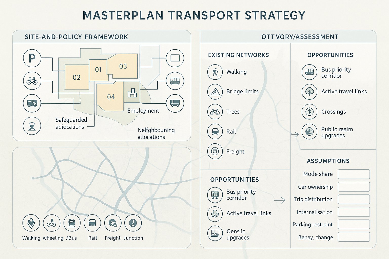
A strong starting point is to map the development properly: land-use mix, floorspace or unit numbers, likely population and employment, access points, parcel structure and phasing. If the site is strategic, we also need to understand neighbouring allocations, safeguarded corridors, utility constraints and any wider infrastructure commitments that may alter the transport picture over time.
Then comes policy. National policy sets broad expectations around sustainable transport, safety and severe impact tests, but regional and local policy usually shapes the practical response. Parking standards, cycling design guidance, bus service expectations, low-traffic objectives, freight restrictions and accessibility requirements can all vary. So can local authority thresholds for when a transport statement, transport assessment, travel plan or wider masterplan evidence is expected.
That is why local planning context matters so much. At ML Traffic, a big part of our work is tailoring reporting to the authority and planning route involved rather than relying on one-size-fits-all technical notes.
Once the policy framework is clear, we can define assumptions that are realistic and defensible: car ownership, mode share, trip distribution, internalisation, parking restraint and behavioural change measures.
Assessing Existing Networks, Constraints, And Opportunities
A site does not exist on a blank sheet. The existing network often determines whether a strategy is merely compliant or genuinely persuasive.
The assessment should cover walking and wheeling routes, cycle infrastructure, bus services, rail access where relevant, highway conditions, freight routes and junction performance. But quality matters as much as presence. A bus stop 400 metres away is not especially useful if access is via an unlit, indirect footway with poor crossings. A cycle corridor on a plan may not function if it disappears at the first busy roundabout.
We should also identify hard and soft constraints. Hard constraints include limited bridge capacity, protected trees, topography, flood risk, air quality management areas, safety records, or environmental designations that affect new links. Soft constraints can be political sensitivity, known local objections, school peak pressure, or an authority’s concern about rat-running and overspill parking.
And then there are opportunities, which are easy to underplay. Perhaps a nearby corridor is earmarked for bus priority. Perhaps an adjacent development is already funding an active travel route. Perhaps a local centre is close enough to support genuine walkability if the right crossing and public realm interventions are made. These things can materially change both trip generation and planning acceptability.
A useful audit does more than list conditions. It explains what the existing network enables, what it limits, and where targeted interventions could unlock a better development pattern.
Forecasting Travel Demand And Trip Generation
Trip generation is still central to transport strategy, but in 2026 it needs to be handled with more care than simply pulling a set of database rates and applying them to a land-use schedule. For masterplanning, we are usually dealing with a dynamic picture: changing phases, mixed uses, internal trip capture, public transport enhancements and policy-led mode shift over time.
So the first principle is proportional realism. The forecasting method must reflect the scale and complexity of the scheme. A modest site may justify a relatively straightforward approach. A strategic urban extension, town centre regeneration area or mixed-use allocation almost certainly needs a broader demand framework tied to phasing and scenario testing.
Recognised tools remain important, including TRICS-style trip-rate analysis where appropriate, census journey data, local surveys and authority datasets. But those inputs should be interpreted, not copied mechanically. Density, tenure, parking restraint, local accessibility and mixed-use interaction can materially alter outcomes.
We also need to distinguish between person trips and vehicle trips. A strategy focused solely on cars will miss the wider question of how demand can be redistributed by mode. That is especially important where the planning case depends on stronger bus use, active travel uptake or reduced peak-hour car dependency.
Scenario testing is often the difference between a fragile and robust strategy. Base case, committed development case, future year case and sensitivity tests should all reflect plausible outcomes, including delayed infrastructure or slower mode shift where relevant.
Selecting The Right Evidence Base, Surveys, And Modelling Approach
The evidence base needs to be broad enough to withstand scrutiny and targeted enough to remain proportionate. We usually start with observed conditions: traffic counts, turning counts, queue observations, journey time information, active travel flows and public transport frequency and load data where available. For larger sites, household or intercept survey evidence can help explain existing travel behaviour and likely demand patterns more credibly than assumptions alone.
Census data still has value, though it should be used carefully and updated with current context. Mobile data, ticketing datasets and other big-data sources can help reveal movement patterns, especially across larger catchments. But none of these should replace grounded site knowledge.
The modelling approach should follow the planning question. If the issue is the operation of a handful of junctions, microsimulation or junction modelling may be enough. If the scheme could redistribute demand across a wider corridor or interact with strategic growth locations, network assignment or a strategic model may be necessary. The key is consistency with local or regional tools where those exist.
Over-modelling can be as problematic as under-modelling. A highly complex model built on weak assumptions is not persuasive. Equally, a simplistic exercise for a major site will not survive review. The right approach is the one that answers the authority’s likely questions, supports design iteration and remains transparent enough to explain in plain English.
That last point matters. Decision-makers do not approve models. They approve developments based on evidence they can understand and trust.
Designing A Multi-Modal Movement Framework
Once demand and context are understood, the strategy needs to turn evidence into a movement framework. This is the stage where transport becomes spatial. We are no longer just asking how many trips occur, but how different users move through the site, which streets carry which functions, and how the development connects into its surroundings.
A strong framework starts with hierarchy. Not every street should do everything. Some routes should prioritise place and social activity. Others should provide bus penetration, servicing access or strategic connection. The hierarchy should be legible, tied to the masterplan structure, and aligned with the intended character of each part of the development.
This is also where integration matters most. Walking routes need to connect naturally to front doors, schools, open spaces and local centres. Cycle infrastructure should be continuous rather than symbolic. Public transport should be planned into the site form, not squeezed in later through awkward turning heads and compromised stop locations. Servicing should work operationally without undermining amenity.
For mixed-use and strategic sites, we should think about movement at more than one scale: internal circulation, edge connections, corridor links and interchange opportunities. The best schemes are often the ones where those layers reinforce each other.
In policy terms, this supports compact, accessible development rather than expansion that simply adds trip length and car dependence. In design terms, it creates a framework that can evolve through reserved matters and later phases without losing coherence.
Prioritising Walking, Cycling, Public Transport, Servicing, And Cars
Mode priority should be explicit. If a strategy says sustainable travel comes first, the design must prove it.
For walking and wheeling, that means direct routes, overlooked streets, frequent crossing opportunities, generous footways where activity is highest, and layouts that reflect real desire lines rather than idealised diagrams. For cycling, continuity is everything. Routes need to feel safe for ordinary users, not just the highly confident minority. Junction treatment, secure parking and links beyond the site boundary are often decisive.
Public transport needs equal seriousness. Can buses move through or around the site efficiently? Are stop locations convenient and accessible? Is there enough density and street structure to support viable services? On larger schemes, public transport corridors, priority measures and safeguarded interchange space may need to be designed in from day one.
Servicing and freight should not be left to the final appendix. Designated routes, loading strategy, refuse collection access and, where relevant, consolidation or delivery management can prevent later conflict with public realm ambitions.
As for cars, the question is management rather than default priority. Vehicle access will still matter on most sites, but parking levels, location, control and pricing all shape travel behaviour. A planning-ready strategy treats the car as one part of the system, not the organising principle for the whole place.
Testing Deliverability, Phasing, And Infrastructure Requirements
A transport strategy is only useful if it can be delivered. This is the point where attractive diagrams and sound principles meet funding, timing, statutory process and buildability.
First, we need to identify the infrastructure package clearly. That may include access junctions, signal upgrades, bridge works, bus service enhancements, pedestrian crossings, cycle links, travel plan measures, parking controls or wider off-site interventions. For larger developments, some elements will be essential to early occupation, while others can be phased as demand grows.
Phasing is critical. Occupation thresholds should align with transport triggers in a way that is practical and evidence-based. Too little early infrastructure and the development risks operational failure or planning resistance. Too much too early and viability can become strained. The strategy should hence set out what is needed at each phase, what assumptions underpin those triggers, and how later stages remain adaptable if conditions change.
Funding and governance then have to be addressed honestly. Which interventions are site-specific and developer-funded? Which rely on local authority capital programmes, combined authority investment, public transport operators or third-party land agreements? If a key mitigation item sits outside the applicant’s control, the planning case needs to explain the delivery route, not bury the risk.
Testing should also cover resilience. What happens if background traffic growth differs from forecast, if bus service uplift arrives later than hoped, or if build-out accelerates? A robust strategy anticipates those questions.
In our experience, concise reporting helps here. Planning teams, legal advisers and officers need a document trail that is technically credible but also easy to follow. That is often where focused, authority-aware transport reporting makes the difference between a strategy that exists on paper and one that genuinely supports consent.
Conclusion
A robust masterplan transport strategy does far more than estimate traffic impact. It provides the evidence, structure and delivery logic that links development ambition to planning reality. When done properly, it shows how a scheme can function across its full life cycle, align with policy, support sustainable travel, and create a place that works for people as well as vehicles.
For architects, planners, developers, lawyers and councils, that matters because transport is often where strategic proposals either gain credibility or lose momentum. The strongest frameworks are grounded in site evidence, realistic assumptions, multi-modal design and clear phasing. They answer not just “can this be accessed?” but “will this place succeed?”
In 2026, that is the standard we should be working to. And if the strategy is prepared early, coordinated properly, and tailored to the authority and scheme in front of us, it becomes one of the most powerful tools in the planning process.
Masterplan Transport Strategy FAQs
What is a masterplan transport strategy and why is it important?
A masterplan transport strategy is a long-term, evidence-based plan that sets out how people and goods will move within and around a development. It is important because it aligns transport investment with land use, supports planning approvals, sustainability goals, and helps create accessible, liveable places.
How does a masterplan transport strategy support planning applications?
It provides an objective evidence base that demonstrates a development’s transport feasibility, aligns with local and regional policies, and sets realistic delivery frameworks. This helps planners, developers, and authorities assess the long-term viability and sustainability of proposed growth.
What are the key objectives of an effective masterplan transport strategy?
Core objectives include decarbonising transport, promoting sustainable travel modes, enhancing social inclusion and health, improving safety and network resilience, supporting economic performance, and protecting environmental quality and place characteristics.
How does a masterplan transport strategy prioritise different transport modes?
It explicitly prioritises walking, cycling, and public transport by designing continuous, safe, and accessible networks, while managing car use through parking controls and demand management. Servicing and freight routes are also designated to minimise conflict with public spaces.
What is involved in assessing the site and policy context for a transport strategy?
This involves mapping land use, development mix and phasing, reviewing national to local transport policies, setting realistic mode share and parking assumptions, and understanding existing transport networks, constraints, and opportunities surrounding the site.
How is deliverability and phasing addressed in a masterplan transport strategy?
The strategy identifies required infrastructure improvements, phases these interventions aligned with development build-out, and tests funding, governance, and risk to ensure each stage of growth remains accessible and sustainable with clear delivery mechanisms.