Tag: car-free development

  • Transport Planning Consultants Islington: Navigating 2026 Planning Approvals

    Transport Planning Consultants Islington: Navigating 2026 Planning Approvals

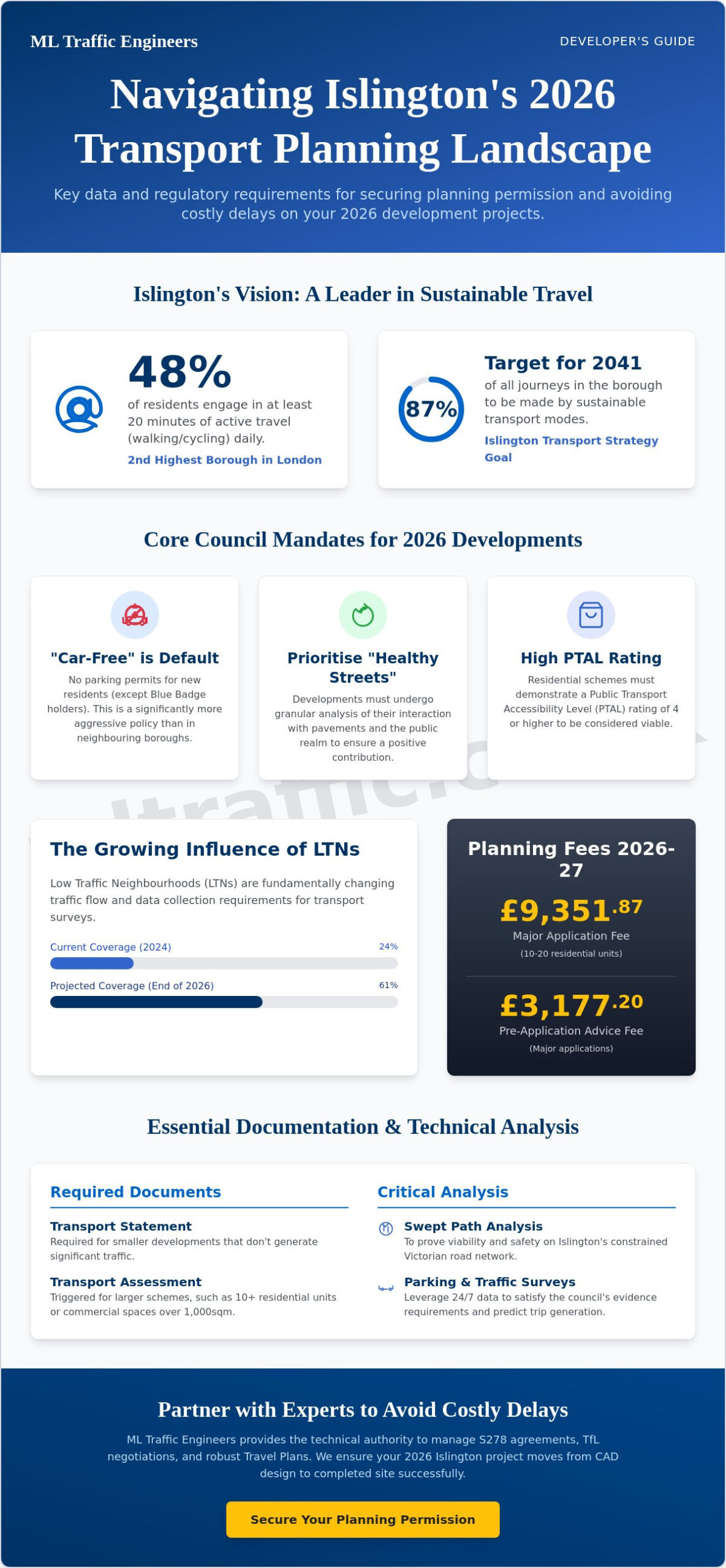
    With 48% of Islington’s population now engaging in at least 20 minutes of active travel every day, the borough ranks as the second highest in London for walking and cycling. This shift is a core pillar of the Islington Transport Strategy which aims for 87% of all journeys to be sustainable by 2041. For developers, this means the margin for error is zero. You’re likely feeling the pressure of Islington Council’s strict “car-free” mandates and the high risk of a planning refusal due to transport concerns. Partnering with experienced Transport Planning Consultants Islington is the only way to ensure your 2026 development project moves from a CAD design to a completed site without costly regulatory delays.

    We understand that coordinating between architects and highway authorities is a logistical burden you don’t need. Our team provides a total, managed solution, from initial Transport Assessments to robust Travel Plans that satisfy the latest 2026 requirements. By reading this guide, you’ll master the complexities of the current planning fees, such as the £9,351.87 charge for major applications, and learn how to use Swept Path Analysis to justify your site’s viability. We’ll show you exactly how to secure planning permission by aligning your project with the council’s vision for a net-zero borough through proactive, data-driven planning.

    Key Takeaways

    • Understand how the Islington Local Plan impacts 2026 planning submissions, specifically regarding car-free mandates and active travel targets.
    • Determine whether your project requires a full Transport Assessment or a Transport Statement based on current London Borough of Islington size thresholds.
    • Master the technical requirements for Swept Path Analysis and Parking Surveys to prove your development’s viability on Islington’s constrained Victorian road network.
    • Professional Transport Planning Consultants Islington provide the technical authority needed to manage S278 agreements and strategic negotiations with Transport for London.
    • Leverage 24/7 traffic survey data and bespoke Travel Plans to satisfy the council’s evidence requirements and minimize the risk of planning refusal.

    Understanding Islington’s Transport Planning Landscape in 2026

    Transport Planning Consultants Islington act as the vital bridge between your development vision and the London Borough of Islington’s (LBI) stringent regulatory framework. In 2026, this role is more technical than ever. We don’t just provide documents; we provide the data-led justification for your project’s impact on the local network. This involves a deep understanding of transportation planning to ensure every submission aligns with the borough’s long-term environmental goals. Our team manages the logistical burdens of the planning process, allowing you to focus on the architectural integrity of your build.

    To better understand the distinction between the planning and engineering roles in this field, watch this helpful video:

    Islington has cemented “car-free” as the default for almost all new developments as of May 2026. Unless you’re building specifically for Blue Badge holders, you won’t get parking permits for residents. This policy is significantly more aggressive than in neighboring Camden or Hackney. It requires precise site selection based on Public Transport Accessibility Level (PTAL) ratings. We use CAD design and detailed site analysis to prove that your project can thrive without traditional vehicle infrastructure.

    The Islington Local Plan and Transport Policy

    The Islington Local Plan mandates that developers prioritize the “Healthy Streets” approach. Unlike other boroughs, LBI requires a highly granular analysis of how a building interacts with the existing pavement and public realm. If your project involves 10 to 20 residential units, you’ll face a planning application fee of £9,351.87 for the 2026 to 2027 period. Islington residential schemes are required to demonstrate a PTAL rating of 4 or higher to successfully support the borough’s mandatory car-free development standards. We ensure your documentation meets these thresholds before you commit to the pre-application advice fee, which currently stands at £3,177.20 for major applications.

    The Shift Toward Sustainable and Active Travel

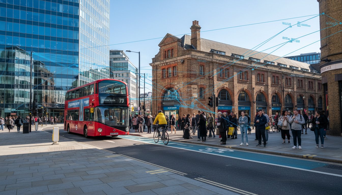
    Active travel is a non-negotiable priority for the council. 48% of residents walk or cycle for at least 20 minutes daily, making Islington the second highest borough in London for this metric as of 2024 data. Low Traffic Neighbourhoods (LTNs) now cover 24% of the borough, with plans to reach 61% by the end of 2026. These zones fundamentally change how we collect traffic data for our surveys. You must align your project with London Travel Plans to show you’re supporting these active travel targets. We provide bespoke solutions that integrate cycle storage and pedestrian access into the very start of your project lifecycle.

    Essential Documentation: Transport Statements and Assessments

    Securing planning approval in 2026 requires more than just a site plan; it demands technical proof of feasibility. Transport Planning Consultants Islington are responsible for determining whether your project requires a Transport Statement or a full Transport Assessment. The London Borough of Islington (LBI) typically requires a Transport Statement for smaller developments that don’t generate significant traffic. Larger schemes, such as those with 10 to 20 residential units or commercial spaces exceeding 1,000sqm, trigger the need for a comprehensive Assessment. We use the TRICS database to predict trip generation accurately, ensuring your project doesn’t exceed the capacity of local infrastructure. Following standards set by the Chartered Institution of Highways & Transportation, we provide the technical rigor necessary to satisfy council officers.

    Transport Statements for Small to Medium Developments

    A robust Islington Transport Statement focuses on the immediate impact of infill projects. Even for “car-free” developments, you must address parking stress for visitors and service vehicles. We conduct detailed Parking Surveys to prove that local highway capacity can handle the added demand. A common pitfall that leads to planning delays is failing to account for the cumulative impact of nearby approved schemes. By providing a total, managed solution, we prevent these administrative bottlenecks. If you aren’t sure which document you need, our team can review your site requirements immediately to ensure compliance.

    Full Transport Assessments for Major Islington Schemes

    Major developments require a deeper level of scrutiny. Our Transport Assessment London guide highlights that for LBI, this includes junction capacity analysis and multi-modal impact studies. You must show how residents will access the site via walking, cycling, or public transport. We integrate air quality and noise data into our reporting to align with the council’s 2030 net-zero goals. Engaging with LBI highways officers for pre-application advice is essential; the current fee for a major application follow-up meeting is £3,177.20. This proactive engagement, supported by our technical data, mitigates potential objections before the final submission. We manage the entire lifecycle of this documentation to keep your 2026 project on track.

    Transport Planning Consultants Islington: Navigating 2026 Planning Approvals

    Technical Precision: Swept Path Analysis and Parking Surveys

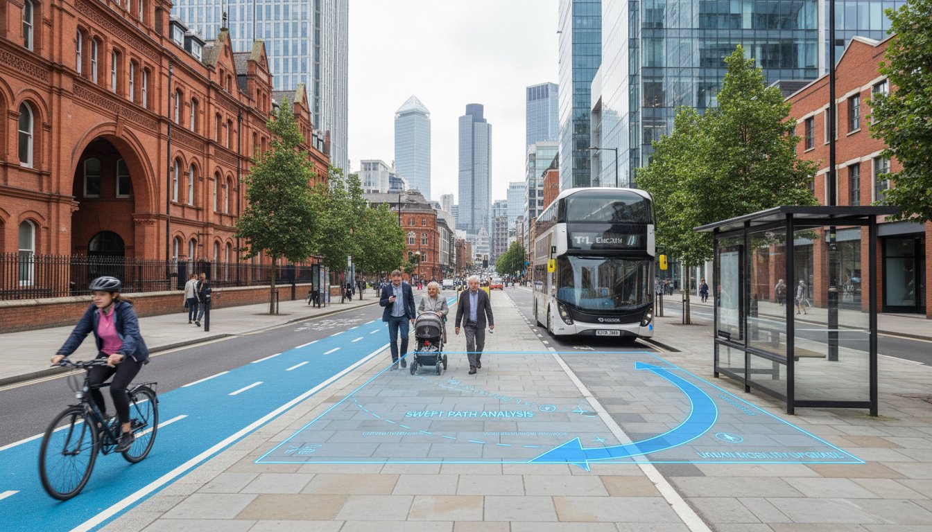
    Islington’s Victorian street layout presents unique logistical challenges that require surgical precision during the planning phase. Transport Planning Consultants Islington must provide definitive proof that a site is accessible before a single brick is laid. This is where technical data replaces guesswork. We utilize advanced CAD modeling to simulate vehicle movements, ensuring that your development doesn’t create a safety hazard or a traffic bottleneck. By integrating Swept Path Analysis Services early in the project lifecycle, we identify potential access issues that would otherwise trigger costly design revisions during the council’s review process. Our approach prioritizes safety and regulatory compliance, giving you a clear path to approval.

    Swept Path Analysis for Tight Urban Access

    Islington Council (LBI) is particularly strict about servicing and delivery arrangements on red routes and narrow residential roads. Our team uses industry-standard CAD software to model specific vehicle paths, ensuring that every truck can enter and exit the site in a forward gear. This is a non-negotiable safety requirement for urban projects. For all major residential and commercial schemes, LBI mandates the use of 12m refuse vehicle templates as the standard for verifying waste collection access. We also model fire tender movements to guarantee that emergency services aren’t obstructed by the building’s footprint or tight corner radii. This technical precision removes the ambiguity from your submission and demonstrates that your site is fit for purpose.

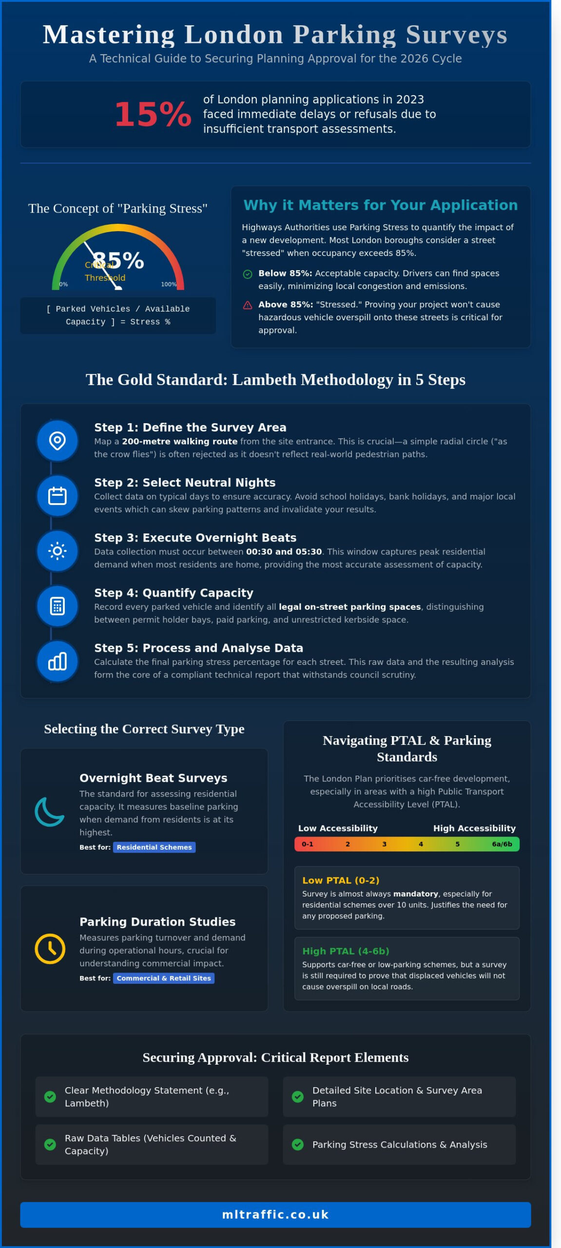
    Parking Surveys and Stress Testing

    While Islington’s “car-free” policy is the default, you must still justify the lack of parking through rigorous stress testing. We conduct Parking Surveys using the Lambeth Methodology to assess the available on-street capacity within a 200m radius of the site. This methodology is the gold standard for London boroughs and is expected by LBI highways officers. This data is essential for developments in PTAL 5 and 6 zones, where the council expects high public transport usage but still requires evidence of local impact. Our 24/7 survey teams perform overnight counts between 00:30 and 05:30 to capture the most accurate snapshot of resident parking demand. We also provide the technical data needed to justify the loss of any on-street bays for new crossovers or access points. By delivering a comprehensive data set, we ensure the council has no grounds to refuse your application based on parking concerns.

    Strategic Negotiations: S278 Agreements and TfL Engagement

    Strategic negotiation is where a project’s technical data meets the legal reality of the public highway. Transport Planning Consultants Islington don’t just stop at the application stage; we guide you through the financial and regulatory commitments required to break ground. Section 278 (S278) agreements are the primary mechanism for this. These legal contracts allow you to make permanent alterations to the public road, such as new junctions or pavement widening. For major works valued over £1m, the drawing approval fee is £6,380 for the 2026-2027 period. Even small-scale works up to £25,000 require a £570 fee. We manage these technical approvals to prevent your project from stalling after you’ve already secured planning permission.

    A critical gap in many submissions is the lack of integration between initial transport reports and the eventual logistics of the build. While our focus remains on the planning data, we ensure your Transport Assessment aligns with the requirements of a Construction Logistics Plan Consultant. This alignment is vital for clearing pre-commencement triggers. If your transport report doesn’t account for the physical constraints of the 2026 streetscape, you’ll face delays when applying for a Street Works Licence. New “Additional Short notice” fees were introduced in January 2026 for applications submitted without the correct notice period, making early coordination a financial necessity.

    The S278 Agreement Process in London

    The S278 process follows a strict sequence that we manage on your behalf. First, we secure technical approval of the highway designs from the local authority, ensuring they meet current safety standards. Next, we help you navigate the bonding process, where a financial guarantee is set aside to cover the cost of the works. Finally, we oversee the transition into the implementation and maintenance periods. During this phase, the council typically retains a portion of the bond for 12 months to ensure the new road layout performs as expected. Our proactive approach ensures these legal hurdles don’t disrupt your project timeline.

    Coordinating with Transport for London

    Engagement with Transport for London (TfL) is mandatory if your site borders a red route like the A1 (Upper Street). TfL applies the “Healthy Streets” lens to every major application near hubs like Angel or Archway. This means your project must demonstrate a positive impact on the pedestrian environment and public transport network. We negotiate mitigation measures, often involving Section 106 transport contributions, to ensure your development remains viable while meeting London-wide safety standards. If you’re managing a complex site near a TfL route, you can partner with our expert team to navigate these high-stakes negotiations with confidence.

    Partnering with ML Traffic Engineers for Islington Success

    Choosing the right Transport Planning Consultants Islington is the difference between a project that stalls and one that succeeds. ML Traffic Engineers provides a total, managed solution for developers who need to navigate the high-stakes environment of London planning. We position ourselves as a safe pair of hands, an entity that understands the intricate complexities of the 2026 regulatory environment so you don’t have to. Our technical authority balances precision with a customer-centric approach, aiming to alleviate the logistical and regulatory burdens placed on your project team. We manage the entire lifecycle of your transport requirements, from initial feasibility through to final implementation.

    Our 24/7 availability is a primary hallmark of our brand promise. Planning deadlines are often tight and unpredictable. We maintain a constant state of readiness to conduct urgent Traffic Surveys or collect technical data when the council demands immediate evidence. This reliability is essential in the fast-moving world of Islington development. Whether it’s an overnight Parking Survey using the Lambeth Methodology or a rapid CAD design revision for a Swept Path Analysis, our team is available to ensure your submission remains on track. We take immense pride in our precision and compliance, viewing our role as a vital partner in your project’s success.

    Why Local Expertise Matters

    Success in the London Borough of Islington (LBI) requires more than just technical skill; it requires local insight. We have a deep understanding of what we do specifically for the Islington context. Our team has direct experience with LBI highways officers and understands the specific nuances of the Islington Local Plan. We’ve successfully managed various project types across North London, ranging from small-scale infill residential units to major commercial developments. In early 2026, we secured approval for a challenging site near Highbury Corner by utilizing data-driven justifications that satisfied the council’s strict car-free mandates. This proactive approach prevents the common pitfalls that lead to planning refusal.

    Get Started with Your Islington Project

    Securing your 2026 planning approval starts with a robust fee proposal tailored to your site’s specific constraints. We provide comprehensive support for both Transport Statements and full Transport Assessments. Our initial consultations include site access reviews and feasibility checks to identify potential highway issues before they become expensive problems. We use bespoke solutions and seamless integration to ensure your transport documentation aligns perfectly with your architect’s vision. Contact us at mltraffic.co.uk for immediate expert support. Let our team manage the technical complexities while you focus on delivering a high-quality development for the Islington community.

    Securing Your Development’s Future in Islington

    Successful planning applications in May 2026 require more than just compliance; they demand a proactive strategy built on technical data. You’ve seen how Islington Council’s strict car-free policies and the 87% sustainable travel target by 2041 leave no room for error. Whether you’re navigating the £9,351.87 fee for major applications or negotiating complex S278 agreements, precision is your greatest asset. Our team provides the technical authority needed to justify every aspect of your site access and trip generation. We focus on results so you can focus on construction.

    As specialist Transport Planning Consultants Islington, we act as a safe pair of hands for your 2026 development. We offer 24/7 availability for urgent surveys and bring expert witness experience to planning appeals. We ensure your documentation, from Swept Path Analysis to Travel Plans, meets the highest safety and regulatory standards. Don’t let logistical burdens or planning delays derail your timeline. Request a Transport Planning Quote for Your Islington Project today. We’re ready to help you secure approval and move your project toward a successful completion.

    Frequently Asked Questions

    Do I need a transport consultant for a small extension in Islington?

    You don’t usually need a consultant for a simple residential extension. However, you must hire Transport Planning Consultants Islington if your project creates a new crossover or alters the public highway. Islington Council (LBI) often requests a brief Transport Statement for small commercial conversions to ensure local capacity isn’t overwhelmed. We provide the technical data required to clear these minor planning hurdles quickly.

    What is the “car-free” policy in Islington and how does it affect my project?

    Islington’s car-free policy is the mandatory standard for almost all new developments as of May 2026. This means the council won’t issue on-street parking permits to future residents or occupiers. The only exceptions are for Blue Badge holders or specific operational needs. You must demonstrate how your site will function without private vehicle access by providing robust Travel Plans and highlighting local public transport links.

    How long does it take to prepare a Transport Statement for an Islington application?

    A standard Transport Statement typically takes 14 to 21 days to complete. This timeline includes the 24/7 data collection phase and the technical drafting of the report. If your site requires a multi-day Parking Survey or complex Swept Path Analysis, the process might extend to four weeks. We maintain a constant state of readiness to meet tight submission deadlines and prevent administrative delays.

    Can I get planning permission in Islington if my site has a low PTAL rating?

    You can secure planning permission with a low PTAL rating, but the council requires stronger evidence of sustainability. Sites with a PTAL of 0 or 1 must prove they won’t increase local parking stress. We use detailed Traffic Surveys to show that your development’s trip generation remains minimal. High-quality Travel Plans that prioritize cycling and walking are essential for overcoming a site’s public transport limitations.

    What is a Swept Path Analysis and why is it required for my Islington site?

    Swept Path Analysis is a CAD-based simulation that proves vehicles can safely navigate your site’s access points. It’s a non-negotiable requirement for Islington’s narrow Victorian streets. We model the movements of 12m refuse vehicles and fire tenders to ensure emergency and service access. This technical precision prevents the council from refusing your application based on highway safety concerns or restricted vehicle maneuverability.

    How much does a parking survey cost for a London planning application?

    We don’t provide fixed pricing for surveys because costs vary based on the number of streets covered and the survey duration. However, it’s worth noting that Islington’s 2026-2027 fee schedule includes a £570 charge for S278 works up to £25,000. Our team provides bespoke fee proposals after an initial site review. This ensures you only pay for the specific data required for your unique planning application.

    What is the difference between an S278 and an S106 agreement in transport planning?

    An S278 agreement is a legal contract for physical works on the public highway, such as a new junction. Conversely, an S106 agreement involves financial contributions to mitigate the development’s impact on the wider community. While S278 covers the actual road construction costs and bonds, S106 might fund local bus improvements or cycling infrastructure. We manage the technical negotiations for both to keep your project compliant.

    How do Low Traffic Neighbourhoods (LTNs) in Islington affect traffic surveys?

    Low Traffic Neighbourhoods (LTNs) cover 24% of Islington and fundamentally change local traffic flow. When we conduct Traffic Surveys, we must account for these restricted routes to ensure our data reflects real-world conditions. The council expects survey data to show how your development interacts with these “Liveable Neighbourhoods.” We use 2024-2025 baseline data to provide a comparative analysis that satisfies LBI highways officers.

    Michael Lee

    Article by

    Michael Lee

    Transport planner with over 35 years' experience.

    Disclaimer

    The content on mltraffic.co.uk, including all technical articles, guides, and resources, is provided for general informational and educational purposes only. It is not intended to constitute professional advice in traffic engineering, transportation planning, development approvals, or any other technical or legal field.
    While ML Traffic Engineers makes every reasonable effort to ensure the accuracy, completeness, and timeliness of the information published, we do not provide any warranties or representations (express or implied) regarding its reliability, suitability, or availability for any particular purpose. Any reliance you place on the content is strictly at your own risk.
    In no event shall ML Traffic Engineers, its directors, employees, authors, or affiliates be liable for any direct, indirect, incidental, special, consequential, or punitive damages (including, without limitation, loss of profits, data, or business opportunities) arising out of or in connection with the use of, or inability to use, any information provided on this website.
    The articles and guides on this site are not a substitute for engaging a qualified, professional traffic engineer to assess your specific project requirements. For tailored advice, compliance assessments, or traffic engineering services, please contact a competent professional.
    This disclaimer may be updated from time to time without notice. By accessing or using this website, you agree to be bound by the most current version of this disclaimer.

  • Transport Planning Consultants Tower Hamlets: A Developer’s Guide to 2026 Approvals

    Transport Planning Consultants Tower Hamlets: A Developer’s Guide to 2026 Approvals

    In Tower Hamlets, your development’s success no longer hinges on how many cars you can fit; it depends on how many you can keep away. With the New Local Plan 2023–2038 submitted for examination on February 16, 2026, the borough has pivoted sharply toward active travel integration. As specialist Transport Planning Consultants Tower Hamlets, we recognize that the old traffic mitigation mindset is now a fast track to a planning refusal.

    You probably feel the weight of these shifting requirements, especially with the Court of Appeal’s January 22, 2026, ruling reinforcing the Mayor’s control over Low Traffic Neighbourhoods. Whether you’re struggling with PTAL ratings on the Isle of Dogs or the new 2026 CIL indexation rates, the regulatory burden is significant. This guide simplifies the process by providing the technical insights necessary to navigate Tower Hamlets’ safety standards and sustainability targets. You’ll learn exactly which transport reports are mandatory for 2026 and how to align your project with the borough’s 27% cycling growth to ensure a seamless approval.

    Key Takeaways

    • Identify the specific criteria for Transport Statements and Assessments to ensure your LBTH planning application is validated without technical delays.
    • Navigate high PTAL ratings in areas like Bethnal Green by implementing car-free development strategies that align with 2026 sustainability targets.
    • Use technical Swept Path Analysis and the Lambeth Methodology for parking surveys to mitigate highway safety objections and fire access concerns.
    • Partner with specialist Transport Planning Consultants Tower Hamlets to bridge the gap between your development goals and the borough’s complex highways regulations.
    • Leverage 24/7 availability for urgent traffic survey requirements and a managed solution that covers your project from initial CAD design to final implementation.

    Why You Need Specialist Transport Planning Consultants in Tower Hamlets

    In the London Borough of Tower Hamlets (LBTH), transport planning validation is the gatekeeper of your project timeline. It involves more than just drafting a site map; it’s a technical discipline that aligns your development goals with the borough’s strict safety and environmental standards. Professional transportation planning ensures your proposal meets the legal requirements for highway safety and public access from day one. Without this precision, developers face the immediate financial risk of planning refusal. These setbacks often stem from inadequate data or a failure to address the borough’s specific movement strategies.

    Expert Transport Planning Consultants Tower Hamlets act as a vital bridge between your design team and the local highways officers. We translate complex architectural visions into the technical language that LBTH officials require for validation. This technical authority is essential because 2026 regulations now demand comprehensive active travel integration rather than simple traffic volume counts. We manage the logistical and regulatory burdens so you don’t have to.

    To better understand the evolution of these planning tools, watch this helpful video:

    Navigating the Tower Hamlets Local Plan 2031

    The “Vision for Tower Hamlets” focuses on high-density growth and reduced car dependency. With the New Local Plan 2023–2038 submitted for independent examination on February 16, 2026, the requirements for site access have become more stringent. Our consultants interpret how programs like “Liveable Streets” affect your specific site layout and access points. We prioritize obtaining pre-application advice from highways officers. This early engagement identifies potential objections before they become costly roadblocks during the formal application phase. It’s about securing a safe pair of hands for your project’s future.

    The 2026 Regulatory Landscape for London Developers

    The London Plan 2021/2026 has introduced rigorous parking maximums that effectively mandate car-free developments in high PTAL areas. These updates, combined with the expanded ULEZ and the Mayor’s Vision Zero policy, have transformed transport reporting. Modern reports must prove a 15% overall casualty reduction on roads, mirroring borough-wide successes seen between 2017 and 2023. At ML Traffic Engineers, we stay ahead of these statutory changes by integrating bespoke technical solutions into every report. We ensure your project addresses the 20% reduction in child casualties required by current safety standards, providing the unwavering reliability needed for 2026 approvals.

    Essential Deliverables: Transport Statements and Assessments in LBTH

    Securing planning approval in Tower Hamlets requires a robust technical submission that addresses the borough’s unique highway constraints. The primary deliverables include Transport Statements and Transport Assessments. These documents provide the evidence base for your development’s impact on the local network. We use the TRICS database to predict trip generation with high precision, comparing your site against similar developments across London. This data-driven approach is essential for 2026 approvals, as it allows us to model junction capacity and multi-modal traffic flow accurately.

    A failed submission often ignores the cumulative impact of neighboring projects. Our team ensures that your reports account for the 20.4% projected population growth in the borough between 2022 and 2032. We provide a managed solution that covers everything from initial CAD design to final implementation, acting as a safe pair of hands for your application. If you’re facing tight deadlines, our technical team is available 24/7 to finalize your sustainable transport strategy.

    Transport Statements vs. Assessments: Which Do You Need?

    The requirement depends on the scale of your project. Generally, developments exceeding 80 residential units or 1,000 square meters of floor space require a full Transport Assessment. For smaller schemes, a Transport Statement is typically sufficient. However, Tower Hamlets officers frequently demand Statements for even minor ‘car-free’ developments in areas with high PTAL ratings. Understanding the Transport Statement vs. Assessment: London Differences is vital for setting your project’s budget and timeline. As experienced Transport Planning Consultants Tower Hamlets, we determine the exact level of detail required to satisfy LBTH Highways and avoid unnecessary technical delays.

    Travel Plans: More Than Just a Document

    Travel Plans are now a mandatory component for most Tower Hamlets applications. These are living documents designed to reduce single-occupancy vehicle trips and promote the borough’s 27% cycling participation rate. A successful Travel Plan includes site-specific measures such as subsidized transit passes or expanded cycle storage. For major residential schemes, you’ll likely need a dedicated Travel Plan Coordinator to oversee these initiatives for at least five years. This proactive management helps mitigate ‘unacceptable’ transport impacts that could otherwise lead to a refusal.

    Transport Planning Consultants Tower Hamlets: A Developer’s Guide to 2026 Approvals

    Tower Hamlets Specifics: PTAL Ratings and Active Travel

    PTAL (Public Transport Accessibility Level) is the primary metric Tower Hamlets uses to dictate parking density and development scale. In 2026, high PTAL scores of 5 or 6 in areas like Bethnal Green and Spitalfields make car-free development a mandatory requirement. We utilize Transport for London’s 100m x 100m grid resolution data from 2023 to verify these ratings with total precision. For developers, this means shifting focus from traditional parking bays to Active Travel Zone (ATZ) assessments. These assessments are now a non-negotiable 2026 standard; they require a detailed audit of walking and cycling routes within a 20 minute radius of your site to ensure safety and connectivity.

    Our role as Transport Planning Consultants Tower Hamlets is to prove your site can handle increased density without adding to road congestion. We analyze existing infrastructure to ensure your project aligns with the borough’s 15% overall casualty reduction targets. This technical authority helps you avoid highway safety objections that often stall major schemes in the borough’s densest wards. We provide the technical evidence needed to satisfy officers that your development supports the borough’s goal of a cleaner, greener environment.

    Understanding PTAL in the Isle of Dogs and Canary Wharf

    The Elizabeth Line has significantly recalibrated PTAL ratings across the borough, turning previously isolated spots into transport hubs. While Canary Wharf enjoys elite connectivity, pockets of the Isle of Dogs and Blackwall still present accessibility challenges. We specialize in justifying development in these lower PTAL areas by proposing targeted infrastructure improvements. This might include new pedestrian links or improved bus stop facilities to bridge the accessibility gap. For smaller projects, our expertise in Flat Conversions in London ensures that even complex subdivisions meet PTAL-based parking constraints without triggering a refusal.

    Integrating Active Travel and Cycling Infrastructure

    With 27% of residents now cycling, LBTH demands infrastructure that exceeds basic racks in a basement. We design secure, accessible storage that strictly adheres to the London Cycle Design Standards (LCDS). Your site entrance must also account for the heavy flow of Cycle Superhighways CS2 and CS3. Our CAD design team ensures these interfaces are safe and functional, preventing conflicts between residents and high-speed cycle traffic. We provide a total, managed solution that integrates these active travel requirements into your initial planning phase, ensuring your site is ready for the 2026 regulatory environment.

    Technical Precision: Swept Path Analysis and Parking Surveys

    Technical precision is the foundation of a successful planning application in East London. As Transport Planning Consultants Tower Hamlets, we provide the rigorous data collection needed to satisfy the borough’s highways department. Our team conducts detailed traffic counts and pedestrian flow surveys to establish a baseline for your site. We don’t just guess; we use CAD design to simulate real-world movements. This level of detail is particularly critical for sites near the Limehouse Cut or Regent’s Canal, where we must coordinate with the Canal & River Trust to ensure development doesn’t impede waterway maintenance or emergency towpath access.

    Our technical authority extends to managing the logistical burdens of night-time economy areas. In districts like Shoreditch and Brick Lane, we perform ‘Stress Surveys’ to measure peak parking and traffic demand during evening hours. This data ensures your development won’t exacerbate existing congestion, aligning with the borough’s safety standards. If you need immediate technical support for your site layout, book a consultation with our CAD engineers today.

    Swept Path Analysis for Narrow Tower Hamlets Streets

    Tower Hamlets features some of London’s most challenging historic street layouts. We use Swept Path Analysis Services in London to model the movement of 12m refuse vehicles and emergency fire tenders. For high-rise developments in Poplar, proving fire tender access is a non-negotiable safety requirement. We simulate various approach angles to ensure these critical vehicles can navigate tight corners without overrunning curbs or striking street furniture. This precision supports the borough’s goal of a 20% reduction in child casualties by ensuring service vehicles operate safely in residential zones.

    Overcoming Parking Objections with Robust Data

    Parking objections are a common cause of planning delays. To mitigate this, we conduct parking surveys using the ‘Lambeth Methodology,’ which is the gold standard in LBTH. We analyze on-street capacity within a 200m radius of your site during the early morning hours when residents are most likely to be at home. This data allows us to justify ‘car-free’ schemes even when local parking appears at capacity. We also address the impact of Controlled Parking Zones (CPZs) on new residents, ensuring your proposal complies with the New Local Plan 2023–2038 policies regarding on-street stress levels.

    Partnering with ML Traffic Engineers for Planning Success in Tower Hamlets

    Securing a planning approval in the current regulatory climate requires a partner who treats precision as a legal necessity. We position ourselves as a safe pair of hands, ensuring your development meets the strict 2026 safety standards set by the London Borough of Tower Hamlets. As experienced Transport Planning Consultants Tower Hamlets, we manage the intricate complexities of UK road regulations so you don’t have to. Our team provides a total, managed solution that moves your project seamlessly from the initial consultation through to final implementation.

    The high-stakes nature of traffic management in East London demands a sense of readiness and urgency. We offer 24/7 availability for urgent survey requirements, which is a primary hallmark of our brand promise. Whether you need a rapid response for a parking survey or a late-night traffic count in a busy night-time economy zone, we’re ready to act. This constant availability ensures that busy project managers can maintain their timelines without navigating through unnecessary delays or logistical hurdles.

    Our approach balances technical authority with a customer-centric focus. We develop bespoke transport solutions that protect your return on investment while ensuring full compliance with the New Local Plan 2023–2038. By prioritizing clarity and speed of information, we help you clear the final hurdles of the planning process with confidence. Contact our technical team today to discuss your project requirements and receive a professional, safety-conscious quote.

    Why Experience in East London Matters

    Success in LBTH depends on a deep understanding of local constraints and a history of successful negotiations with highways officers. We know how the borough’s team interprets the London Plan 2021/2026, especially regarding sites near the Limehouse Link or the A12 corridor. Our expertise allows us to anticipate potential objections before they lead to a refusal. You can view What We Do – Our Full Range of Transport Services to see how we’ve helped other developers navigate these specific East London challenges. We use the active voice to demonstrate capability and immediate action on every project we undertake.

    Start Your Tower Hamlets Project with a Site Appraisal

    The most effective way to save on design fees is to identify transport risks before you commit to a site. A pre-acquisition transport appraisal identifies PTAL limitations or access constraints that could impact your development’s density. We provide these technical insights early in the lifecycle to ensure your project remains viable and compliant. You can access our technical library and Resources to learn more about the safety standards and legislative compliance that form the foundation of our work. Our rhythmic efficiency and professional integrity make us the vital guardian of your project’s planning success.

    Accelerate Your Highway Approval in Tower Hamlets

    The 2026 planning landscape in East London requires a shift from simple traffic counts to comprehensive active travel integration. Navigating the New Local Plan 2023–2038 demands technical precision, especially when dealing with the borough’s historic street layouts and high PTAL zones. As specialist Transport Planning Consultants Tower Hamlets, we provide the technical authority needed to clear these hurdles. We specialize in Swept Path Analysis for narrow London streets, ensuring fire tenders and refuse vehicles maintain safe access in Poplar and beyond.

    Our team offers 24/7 availability for emergency survey data, providing a safe pair of hands when deadlines are tight. We leverage expert knowledge of the LBTH Local Plan 2031 to justify your development’s impact and secure highway validation. By partnering with a firm that prioritizes safety and legislative compliance, you alleviate the regulatory burden on your design team. It’s about moving from uncertainty to a guaranteed technical solution.

    Secure your Tower Hamlets planning approval with ML Traffic Engineers today. We’re ready to transform your site’s transport constraints into a validated, compliant success.

    Frequently Asked Questions

    Is a Transport Statement mandatory for all developments in Tower Hamlets?

    A Transport Statement isn’t mandatory for every minor internal refurbishment, but it’s required for any development creating a net increase in residential units or commercial floor space. Tower Hamlets officers often request these reports for even single-unit conversions in high PTAL areas to confirm car-free compliance. Professional Transport Planning Consultants Tower Hamlets ensure these documents meet the borough’s specific validation requirements to avoid immediate technical rejection or costly delays.

    What is the ‘car-free’ policy in Tower Hamlets and how does it affect my project?

    The ‘car-free’ policy, rooted in the Tower Hamlets Local Plan and the London Plan 2021/2026, prohibits residents in new developments from obtaining on-street parking permits. This policy applies to almost all new residential projects in areas with high public transport accessibility. You must provide a legal agreement under Section 106 to enforce this restriction. It ensures that the 20.4% projected population growth doesn’t lead to gridlock on local roads.

    How long does it take to complete a Transport Assessment for a LBTH application?

    A standard Transport Assessment for a London Borough of Tower Hamlets (LBTH) application typically takes four to six weeks to complete. This timeline includes seven days for automated traffic counts and the technical modeling required for junction capacity analysis. Complex major schemes may require longer if extensive pre-application discussions with highways officers are necessary. Our 24/7 availability for data collection helps compress these timelines for urgent planning deadlines.

    Does Tower Hamlets require a specific parking survey methodology?

    Yes, Tower Hamlets strictly requires the ‘Lambeth Methodology’ for all on-street parking surveys. You must survey a 200m radius around the site on two separate weekday mornings between 00:30 and 05:30. This data proves whether there’s sufficient capacity for visitor parking or if local ‘stress’ levels exceed the 85% threshold. Using this specific methodology is a non-negotiable requirement for a successful planning validation in 2026 and beyond.

    What happens if TfL objects to my planning application in Tower Hamlets?

    If Transport for London (TfL) objects, you must address their concerns through technical mitigation or design revisions before the Planning Committee meets. Objections often relate to site access near the Strategic Road Network or impacts on bus journey times. As Transport Planning Consultants Tower Hamlets, we negotiate directly with TfL officers to resolve these issues. We use CAD design to prove that your site entrance doesn’t compromise the safety of the red route network.

    Can Swept Path Analysis help reduce the land required for my site access?

    Yes, Swept Path Analysis optimizes the site layout by proving exactly how much space a 12m refuse vehicle or fire tender needs to turn. By simulating these movements with CAD software, we often reduce the land dedicated to oversized access roads. This technical precision allows you to maximize the developable area while maintaining full safety compliance. It’s a vital tool for high-density projects in narrow East London streets where space is at a premium.

    How much does a transport planning consultant cost for a London project?

    Fees for transport consulting in London vary significantly based on the project’s scale and the complexity of the required reports. A basic Transport Statement for a minor conversion costs less than a full multi-modal Assessment for a major Poplar high-rise. While we don’t provide fixed prices here, industry data suggests that technical reporting typically accounts for a small percentage of the total planning budget. Contact our team for a bespoke, safety-conscious quote.

    What is an Active Travel Zone (ATZ) assessment?

    An Active Travel Zone (ATZ) assessment is a mandatory audit of the walking and cycling environment within a 20 minute radius of your development. It follows the Mayor of London’s ‘Healthy Streets’ approach to identify improvements needed for pedestrian safety and cycle connectivity. These assessments are now a standard requirement for 2026 approvals. They ensure your project contributes to the borough’s target of a 15% overall casualty reduction on local roads.

    Michael Lee

    Article by

    Michael Lee

    Transport planner with over 35 years' experience.

    Disclaimer

    The content on mltraffic.co.uk, including all technical articles, guides, and resources, is provided for general informational and educational purposes only. It is not intended to constitute professional advice in traffic engineering, transportation planning, development approvals, or any other technical or legal field.
    While ML Traffic Engineers makes every reasonable effort to ensure the accuracy, completeness, and timeliness of the information published, we do not provide any warranties or representations (express or implied) regarding its reliability, suitability, or availability for any particular purpose. Any reliance you place on the content is strictly at your own risk.
    In no event shall ML Traffic Engineers, its directors, employees, authors, or affiliates be liable for any direct, indirect, incidental, special, consequential, or punitive damages (including, without limitation, loss of profits, data, or business opportunities) arising out of or in connection with the use of, or inability to use, any information provided on this website.
    The articles and guides on this site are not a substitute for engaging a qualified, professional traffic engineer to assess your specific project requirements. For tailored advice, compliance assessments, or traffic engineering services, please contact a competent professional.
    This disclaimer may be updated from time to time without notice. By accessing or using this website, you agree to be bound by the most current version of this disclaimer.

  • Lambeth Parking Survey Methodology: The 2026 Developer’s Guide to Planning Approval

    Lambeth Parking Survey Methodology: The 2026 Developer’s Guide to Planning Approval

    Your 2026 London development project could face an immediate planning refusal because of a single data error recorded at 02:00. Securing planning permission in Lambeth requires more than just a standard traffic count; it demands strict adherence to the lambeth parking survey methodology. We understand that the pressure to prove parking stress levels are manageable is immense, especially when a single mistake during the 01:00 to 05:30 observation window can invalidate your entire application.

    You’re likely concerned about the precision needed for 200-metre walking distance calculations or how to justify a car-free development to a sceptical Case Officer. It’s a common frustration for developers who want to keep their project on track. This guide provides the technical clarity you need to master these requirements and submit a compliant report. We’ll examine the exact data collection standards and show you how to leverage 24/7 expert monitoring to ensure your project moves from the planning phase to final implementation without a hitch.

    Key Takeaways

    • Understand why this technical framework is the industry-standard requirement for securing planning permission across London’s most competitive boroughs.

    • Master the mandatory survey parameters, including the strict 200-metre walking distance radius and the non-negotiable 01:00 to 05:30 observation window.

    • Learn how to apply the lambeth parking survey methodology to calculate parking stress and successfully navigate the critical 80% capacity threshold.

    • Identify borough-specific variations in Southwark, Wandsworth, and Lewisham to ensure your technical submission meets local regulatory expectations.

    • Discover why professional data collection is essential to provide the accuracy required to prevent planning refusals and costly project appeals.

    Table of Contents

    What is the Lambeth Parking Survey Methodology?

    The lambeth parking survey methodology represents the benchmark for quantifying on-street parking capacity across the capital. While originally developed by Lambeth Council, it has since become the industry-standard framework adopted by the majority of London boroughs. It functions as the primary evidence-based tool for developers to prove that a new project won’t cause unacceptable parking pressure on local residents. This rigorous assessment is a non-negotiable requirement for any project where the proposed parking provision falls below local authority standards. It ensures that the Technical aspects of urban planning are balanced with the practical realities of street-level infrastructure.

    For developers in 2026, precision is vital. Planning committees don’t accept guesswork. They demand empirical data. The methodology provides a clear, mathematical snapshot of how many cars are parked within a specific radius of a site. It’s the foundation of a successful planning application, especially for high-density residential schemes. Without this data, your project risks immediate rejection on the grounds of transport impact. We provide the technical expertise to ensure your survey meets these exacting standards from the first day.

    To better understand the practical side of parking management in the borough, watch this helpful video from Lambeth Council:

    The Core Purpose of the Survey

    The methodology’s main goal is to establish a baseline of existing parking demand during peak residential times. This usually involves two separate counts between 12:30 am and 5:30 am on weekday nights. These specific hours capture the maximum number of residents at home. The data provides the empirical evidence needed to support car-free or car-capped developments. It directly satisfies the requirements of the National Planning Policy Framework (NPPF), which states that development should only be refused on highways grounds if there’s an unacceptable impact on safety or a residual cumulative impact. By using the lambeth parking survey methodology, you provide the clear evidence needed to mitigate these concerns.

    Why ‘Lambeth’ is the London Standard

    Consistency across different local authorities is the main reason this methodology dominates the market. It prevents methodology hopping, where developers might try to use less rigorous standards to hide parking issues. For Planning Committees, it offers a transparent and repeatable metric that they can trust. This level of standardisation simplifies the approval process. The survey results integrate naturally with Transport Statements and Assessments, forming a cohesive argument for your site’s viability. It’s a reliable system that allows us to manage your project’s regulatory burdens with total precision.

    The Technical Framework: Radius, Timing, and Capacity

    Precision is the foundation of the lambeth parking survey methodology. It’s not a simple tally of vehicles; it’s a rigorous technical assessment where accuracy determines the success of a planning application. Developers must provide a granular view of local parking stress to satisfy Council requirements and avoid costly delays. This starts with a clear understanding of the spatial and temporal boundaries that define the survey’s scope.

    Mapping the 200m Survey Area

    The survey doesn’t use a simple radial "as the crow flies" circle. Instead, it requires a true 200-metre walking distance route from the site entrance. Our team utilizes 1:1250 scale OS mapping to identify every available centimetre of kerbside space within this walkable network. We account for physical obstructions that reduce capacity, including fire hydrants, private driveways, and dropped kerbs. This level of detail is critical because the Planning Inspectorate Appeal Decision has demonstrated that even minor inaccuracies in survey boundaries can undermine a developer’s transport statement. We exclude areas where parking is prohibited, such as double yellow lines or within 10 metres of a junction, to ensure the data reflects legal, safe parking only.

    Standardising the Survey Times

    Data collection must occur during the period of maximum residential parking demand. The non-negotiable window is 01:00 to 05:30. Surveys are conducted on two separate weekday nights, typically a Tuesday and a Wednesday, to provide a representative average of typical parking stress. We strictly avoid anomalous dates. This includes bank holidays, school half-terms, or nights where major local events at venues like the Brixton Academy might skew the results. Our safety-conscious data collectors work through these 24/7 environments in high-visibility gear, capturing snapshots of every parked vehicle to calculate exact occupancy rates. This high-stakes environment demands the unwavering reliability that our field teams provide.

    Calculating Theoretical Capacity

    On unmarked roads, we apply the 5-metre rule. This standard dictates that each 5-metre length of clear kerbside constitutes one parking space. We then cross-reference this against Controlled Parking Zones (CPZs) and specific permit restrictions to determine the true capacity available to residents. For developments with tight access points, we often pair these surveys with Swept Path Analysis services to prove that increased parking occupancy won’t compromise emergency vehicle access or general highway safety. If you’re preparing a submission for a high-density project, our team offers comprehensive support to ensure your data meets the 2026 standard for planning approval.

    Lambeth Parking Survey Methodology: The 2026 Developer’s Guide to Planning Approval

    Calculating Parking Stress and Impact on Planning

    Accurate data interpretation is the backbone of any successful planning application in South London. Under the lambeth parking survey methodology, parking stress is defined as the percentage of kerbside capacity occupied by vehicles at peak times. This figure determines whether your project adds unacceptable pressure to local infrastructure or remains within sustainable limits.

    The calculation is straightforward but requires precise inputs: (Parked Vehicles / Total Capacity) x 100. For instance, if a survey area contains 100 available spaces and 82 vehicles are recorded during the 00:30 to 05:30 window, the parking stress is 82%. Case Officers view the 80% threshold as a critical tipping point. Once occupancy exceeds this level, finding a parking space becomes difficult for residents, often leading to illegal parking or increased congestion. If your survey results sit consistently above 80%, you must prepare a robust justification for your development’s impact.

    A professional technical report must also account for the cumulative impact of other nearby developments. Lambeth Council requires developers to consider committed developments within a 200-metre radius that haven’t been built yet but already have planning permission. Ignoring these future residents can lead to your survey being rejected during the consultation phase because the baseline data fails to reflect the reality of the street’s future capacity.

    Interpreting the Stress Levels

    When stress levels exceed 85% or 90%, the risk of application refusal increases significantly. In these high-stress areas, you can’t simply present the numbers; you must provide mitigation. This often involves permit-free legal agreements, preventing new residents from applying for on-street permits. You might also propose financial contributions to local sustainable transport initiatives or provide on-site car club bays to offset demand. Showing this proactive approach reassures the council that you’ve considered the wider community impact.

    Data Integrity and Transparency

    Transparency is non-negotiable for 2026 planning approvals. ML Traffic provides audit-ready data by including raw data sheets and time-stamped photographs for every street segment surveyed. This level of detail allows council officers to verify results quickly, reducing the likelihood of costly delays or requests for re-surveys. We ensure every lambeth parking survey methodology report is backed by empirical evidence that stands up to scrutiny.

    Linking these survey results to London Travel Plans is a strategic move to reduce car dependency. By showing a clear path toward cycling and public transport use, you demonstrate a commitment to Lambeth’s long-term environmental goals. Our team manages this entire process, moving from initial data collection to final report implementation with speed and technical authority.

    Common Pitfalls and Borough-Specific Variations

    Attempting a "DIY" survey is the fastest route to a planning refusal. Local planning authorities require data that is both objective and legally defensible. If your data fails to align with the lambeth parking survey methodology, your application will be deferred or rejected without hesitation. Precision is a legal requirement in the 2026 planning environment. Council officers quickly identify amateur data sets that lack the necessary technical rigour.

    Why Local Authorities Reject Surveys

    Inaccurate mapping of physical restrictions causes immediate failure. If a surveyor misses a 5-metre stretch of double yellow lines or fails to account for a suspended bay, the entire capacity calculation becomes void. We have seen applications rejected because surveys occurred during rail strikes or school holidays when parking demand drops by as much as 20%. The methodology section of your final report must be transparent. It needs to detail exact timings, weather conditions, and any observations of unusual activity that might skew the results. Failure to provide this level of detail suggests a lack of professional oversight.

    Adapting the Methodology Across London

    While Lambeth follows a specific framework, neighbouring boroughs have distinct nuances that developers often overlook. Wandsworth frequently demands weekend surveys for residential developments to capture peak overnight demand that weekday data might miss. Southwark and Lewisham often require additional scrutiny for sites with high PTAL ratings, typically 5 or 6, to ensure car-free developments don’t overwhelm local infrastructure. Consulting with London transport planning experts ensures these site-specific requirements are integrated into the survey design from the start.

    Ignoring seasonal variations is another critical error. Parking pressure in December differs significantly from July. If you conduct a survey during a period of untypical behaviour, such as a major local event or emergency roadworks, the council will identify the anomaly. We cross-reference all survey data with long-term local trends to ensure your 2026 planning submission stands up to the most rigorous council scrutiny. This proactive approach eliminates the need for expensive re-surveys and prevents project delays. Our team identifies these risks before the first surveyor arrives on-site, providing a safe pair of hands for your project’s logistics.

    To ensure your project meets every regulatory requirement, secure your 2026 planning approval with a professionally managed parking survey today.

    Why Professional Execution is Non-Negotiable for Approval

    Lambeth’s 2026 planning landscape leaves zero room for data discrepancies. A single miscounted "beat" or an incorrectly identified parking permit zone (CPZ) can trigger a formal objection from the Highways Department. This often results in a planning appeal, a process that adds an average of 32 weeks to your project timeline and can cost upwards of £12,000 in additional consultancy and legal fees. Precision isn’t just a preference; it’s a financial necessity.

    Utilising a robust lambeth parking survey methodology ensures your data withstands the scrutiny of planning officers. We treat every survey as a legal document. Our data provides the empirical foundation for your planning application, ensuring that claims about local parking capacity are backed by verifiable, timestamped evidence. This data doesn’t exist in a vacuum. It’s a critical component that must be seamlessly integrated into your Transport Assessment to provide a holistic view of the development’s impact.

    Choosing a "safe pair of hands" means you aren’t just buying data; you’re buying regulatory compliance. We understand the intricate nuances of Lambeth’s specific requirements, such as the 200-metre walking distance rule and the exclusion of dangerous junctions from capacity totals. We handle the technical complexities so you can focus on the build.

    The ML Traffic Advantage

    We operate on a 24/7 basis because planning deadlines don’t stick to standard office hours. Our team is ready for emergency and time-sensitive surveys, often deploying staff within 48 hours of instruction. We provide bespoke reporting that speaks the direct language of London Planning Officers, using the specific terminology and data visualisations they expect to see. Our total managed solution covers everything from the initial beat planning to the final report delivery, removing the logistical burden from your project managers.

    Securing Your Planning Quote

    To provide an accurate, fixed-fee quote for your project, our team requires three key pieces of information: the site location, the proposed unit count, and your target submission timeline. We don’t cut corners on safety or quality. Every survey we conduct is fully Chapter 8 compliant, protecting both our workers and the public while ensuring the integrity of the data collected. We’ve maintained a 98% first-time acceptance rate for our reports in 2025, and we’re committed to carrying that standard into 2026.

    Ready to move forward with your application? Contact ML Traffic for a Lambeth Parking Survey Quote today to ensure your project stays on track.

    Secure Your 2026 Planning Approval with Precision Data

    Navigating the lambeth parking survey methodology requires strict adherence to Lambeth Council standards, including the mandatory 200-metre radius rule and specific 1:00 AM to 5:00 AM survey windows. Precision is non-negotiable for developers; even a 2% discrepancy in parking stress calculations can trigger an immediate planning refusal. Your transport assessment must accurately reflect existing CPZ restrictions and overnight capacity to withstand rigorous council scrutiny during the 2026 planning cycle.

    ML Traffic provides the technical authority needed to clear these regulatory hurdles without delay. We offer 24/7 data collection capabilities across all 21 wards in the borough, delivering audit-ready technical reports that align with the latest London Borough requirements. Our team manages the entire process from initial site assessment to final submission, providing a total solution that protects your project’s timeline and budget. We’ve built our reputation on reliability and a deep understanding of UK road regulations, ensuring your data is beyond reproach.

    Get a Professional Lambeth Parking Survey Quote for Your London Project

    We’re ready to help you secure your next approval with data you can trust.

    Frequently Asked Questions

    What is the 200m rule in a Lambeth parking survey?

    The 200m rule defines the survey area as a 200-metre walking distance from the proposed site entrance. This radius covers all publicly accessible kerbside space where residents or visitors might park. Our surveyors map these zones precisely to ensure the data captures local parking capacity within a 3-minute walk of your development.

    Why are parking surveys usually conducted between 1 am and 5 am?

    Surveys occur between 01:00 and 05:00 because this period represents peak residential parking demand. Most residents are home at this time, providing the most accurate baseline for overnight parking stress. We deploy teams during these early hours to ensure your application reflects the highest occupancy levels as required by council standards.

    How many nights are required for a compliant Lambeth parking survey?

    A standard lambeth parking survey methodology requires data collection over two separate weekday nights. These are typically Tuesday and Wednesday or Wednesday and Thursday nights to avoid weekend anomalies. If your development includes a commercial element, the Council may request additional weekend surveys to assess the 24/7 impact on local road networks.

    Can I use the Lambeth Methodology for developments outside of Lambeth?

    Yes, many London boroughs and local authorities adopt this methodology as the gold standard for parking stress assessments. It provides a rigorous framework that satisfies the requirements of the London Plan 2021. We frequently apply these principles in Southwark, Wandsworth, and Merton to ensure planning applications meet strict regional transport criteria.

    What is considered a ‘high’ parking stress level in London?

    Parking stress is considered high once occupancy exceeds 85% of the available kerbside capacity. At this threshold, drivers often circle for more than 5 minutes to find a space, which increases local congestion. If your survey identifies stress levels above 90%, the Council will likely require a robust Travel Plan or a car-free legal agreement.

    What happens if my parking survey shows 100% stress?

    If surveys show 100% stress, the Council will likely refuse applications that increase on-street parking demand. You’ll need to mitigate this by proposing a car-free development or funding a new Controlled Parking Zone (CPZ) through a Section 106 agreement. We provide the technical data needed to negotiate these mitigations with planning officers effectively.

    Do I need a parking survey for a car-free development?

    You still need a survey for car-free developments to prove that overspill won’t impact local safety. Even without allocated spaces, visitors or residents with blue badges might park on-street. A comprehensive lambeth parking survey methodology report demonstrates that the surrounding 200-metre radius can absorb any residual pressure without breaching the 85% stress limit.

    How long is a parking survey report valid for a planning application?

    Parking survey data is generally valid for 6 months from the date of the final site visit. If your planning submission is delayed beyond 180 days, you’ll likely need to commission a fresh assessment to account for local changes. We maintain 24/7 readiness to update your reports quickly if project timelines shift or council requirements evolve.

    Which areas in London do you cover?

    We service Acton, Balham, Barking, Barnes, Barnet, Battersea, Beckenham, Bexleyheath, Brentford, Brixton, Bromley, Camberwell, Carshalton, Charlton, Chelsea, Chiswick, Clapham, Coulsdon, Croydon, Crystal Palace, Dagenham, Dulwich, Ealing, Edgware, Eltham, Enfield, Finchley, Forest Gate, Fulham, Golders Green, Greenwich, Hackney, Hammersmith, Hampstead, Harrow, Hayes, Highgate, Hounslow, Ilford, Islington, Kensington, Kentish Town, Kingston upon Thames, Lewisham, Mitcham, Muswell Hill, New Malden, Notting Hill, Orpington, Peckham, Pinner, Purley, Putney, Richmond, Romford, Ruislip, Sidcup, Southall, Southgate, Streatham, Surbiton, Sutton, Tooting, Tottenham, Twickenham, Uxbridge, Walthamstow, Wembley, West Norwood, Wimbledon, Wood Green, Woolwich, Bethnal Green, Shoreditch, Canary Wharf, Deptford, Leyton, Palmers Green, Stanmore, Upminster, Chislehurst, Erith, Feltham.

    Which cities in England do you cover?

    We service London, Birmingham, Manchester, Liverpool, Sheffield, Leeds.

    Michael Lee

    Article by

    Michael Lee

    Transport planner with over 35 years' experience.

    Disclaimer

    The content on mltraffic.co.uk, including all technical articles, guides, and resources, is provided for general informational and educational purposes only. It is not intended to constitute professional advice in traffic engineering, transportation planning, development approvals, or any other technical or legal field.
    While ML Traffic Engineers makes every reasonable effort to ensure the accuracy, completeness, and timeliness of the information published, we do not provide any warranties or representations (express or implied) regarding its reliability, suitability, or availability for any particular purpose. Any reliance you place on the content is strictly at your own risk.
    In no event shall ML Traffic Engineers, its directors, employees, authors, or affiliates be liable for any direct, indirect, incidental, special, consequential, or punitive damages (including, without limitation, loss of profits, data, or business opportunities) arising out of or in connection with the use of, or inability to use, any information provided on this website.
    The articles and guides on this site are not a substitute for engaging a qualified, professional traffic engineer to assess your specific project requirements. For tailored advice, compliance assessments, or traffic engineering services, please contact a competent professional.
    This disclaimer may be updated from time to time without notice. By accessing or using this website, you agree to be bound by the most current version of this disclaimer.

  • Multimodal Traffic Generation in London: A Developer’s Checklist for PTAL and Use Classes in 2026

    Multimodal Traffic Generation in London: A Developer’s Checklist for PTAL and Use Classes in 2026

    What if the 2020 Use Class overhaul actually makes it harder to justify your London development’s car-free status? Securing planning approval in 2026 requires a flawless understanding of multimodal traffic generation by PTAL and Land Uses (E, B2, B8, C1, C2, C3, F1, F2) and Sui Generis ( pubs/bars, cinemas, hot food takeaways, theatres, scrap yards, and petrol stations). You likely already know that London’s planning environment is increasingly rigid regarding parking provisions, especially in areas with a PTAL rating of 5 or 6. We understand the frustration of interpreting conflicting TRICS data when trying to prove your site’s accessibility to Transport for London (TfL).

    This expert-led checklist ensures your transport assessment stands up to the strictest scrutiny from local planning authorities. You’ll master the nuances of trip generation for complex sites, from Class E commercial hubs to specialised Sui Generis scrap yards and petrol stations. We’ve compiled a clear roadmap for accurate data collection and site layout optimisation to help you achieve planning approval with minimal revisions. We’ll examine how to align your project with the latest London Plan requirements to ensure a seamless transition from the initial CAD design to final implementation.

    Key Takeaways

    • Understand how PTAL ratings act as a critical planning gatekeeper by defining the sustainable density and scale of developments across London’s 32 boroughs.

    • Learn to calculate accurate multimodal traffic generation by PTAL and Land Uses (E, B2, B8, C1, C2, C3, F1, F2) and Sui Generis ( pubs/bars, cinemas, hot food takeaways, theatres, scrap yards, and petrol stations) using the TRICS database and bespoke arrival profiles.

    • Discover why Sui Generis developments require specialised traffic analysis to account for unique arrival and departure patterns that generic data often overlooks.

    • Utilise our 2026 developer’s checklist to identify Use Class overlaps early and verify site accessibility using the latest TfL WebPTAL tools.

    • Mitigate the risk of costly planning delays by leveraging professional transport consultants to navigate the specific regulatory requirements of individual London local authorities.

    Table of Contents

    Decoding London’s Use Classes and PTAL Ratings for 2026

    London’s planning framework requires a strict correlation between the Use Classes Order 1987 and the city’s strategic transport goals. Developers must demonstrate how their projects support the Mayor’s 2041 target for 80% sustainable travel. A central component of this is the Public Transport Accessibility Level (PTAL), which measures the proximity and frequency of the transport network. This metric serves as a critical gatekeeper, dictating everything from building density to the number of permitted parking spaces.

    To better understand how these planning elements work together, watch this helpful video:

    What is PTAL and Why Does it Matter?

    PTAL scores range from 0 to 6b. Higher numbers represent superior access to rail, tube, and bus services. In 2026, sites with a PTAL of 5 or 6 generally require car-free development, with exceptions limited to essential blue badge provision. These ratings directly influence how residents and visitors choose to travel. High accessibility encourages a shift from private vehicles to active travel and public transport. When developers seek to deviate from these rigid standards, parking surveys in London provide the empirical data needed to justify parking reductions. We use these surveys to prove that local streets can handle any residual overspill without compromising safety.

    The 2026 Landscape of Land Use Classes

    The introduction of Class E has streamlined planning but complicated transport modelling for consultants. Since a building can shift from a retail shop to a gym or office without additional planning permission—often housing the kind of small UK businesses found on platforms like Anglia Market—we must model the "worst-case" scenario for trip generation. This ensures safety and capacity compliance regardless of the specific end-user. Accurate forecasting of multimodal traffic generation by PTAL and Land Uses (E, B2, B8, C1, C2, C3, F1, F2) and Sui Generis ( pubs/bars, cinemas, hot food takeaways, theatres, scrap yards, and petrol stations) is now the mandatory baseline for any successful planning application.

    Each land use presents unique challenges for the 2026 transport network:

    • Class E: High-frequency turnover requiring robust pedestrian infrastructure.

    • B2 and B8: Heavy goods vehicle (HGV) movements that must be separated from cycle lanes.

    • C1 to C3: Residential and hotel uses that demand reliable 24/7 public transport links.

    • Sui Generis: High-impact uses like theatres or petrol stations that create intense, time-specific traffic peaks.

    Our team ensures that your project meets these technical requirements from the initial planning phase. We provide the precise data needed to satisfy local authorities and Transport for London, ensuring your development moves from CAD design to final implementation without regulatory delays.

    Calculating Trip Generation for Classes E, B, and C

    Accurate forecasting starts with the TRICS database. It’s the industry standard for establishing baseline multimodal trip rates. However, London’s unique geography requires developers to filter national datasets to match the specific travel behaviours of Central, Inner, or Outer London. A site in Croydon won’t share the same trip profile as one in Southwark, even if the land use is identical. It’s vital to follow official government guidance when preparing these figures to ensure compliance with local planning authority expectations.

    Our methodology ensures precise multimodal traffic generation by PTAL and Land Uses (E, B2, B8, C1, C2, C3, F1, F2) and Sui Generis ( pubs/bars, cinemas, hot food takeaways, theatres, scrap yards, and petrol stations) to meet strict Transport for London (TfL) standards. We don’t just look at vehicle numbers; we calculate the total impact across all transport modes. This includes cycling, walking, and rail usage, which are heavily influenced by the site’s PTAL rating. For projects requiring rapid turnaround, our comprehensive transport planning support ensures your submission stays on track.

    Commercial and Industrial Dynamics (E, B2, B8)

    B8 Storage and Distribution centres in Greater London generate intense delivery and servicing requirements. These sites often see over 15 HGV movements per hour during peak operational windows. Because of these dimensions, swept path analysis services are vital for industrial site access. They prove that large vehicles can enter and exit in a forward gear without mounting pavements or striking street furniture. Class E traffic has also shifted significantly. Since the 2020 reforms, many sites have moved from retail-heavy use to office and gym multimodal splits. This change typically flattens the midday peak but increases pressure during the 08:00 to 09:00 and 17:00 to 18:00 windows.

    Residential and Institutional Impact (C1, C2, C3, F1, F2)

    Forecasting school (F1) and community (F2) traffic requires a granular look at the morning peak hour. These uses often create localised congestion that conflicts with commuter traffic. Residential (C3) developments in low PTAL areas, such as levels 1a or 1b, typically show a 40% higher car dependency compared to Zone 2 locations. In contrast, short-stay C1 uses operate on a different rhythm. C1 hotel trip generation varies significantly by proximity to London Underground stations, with sites within 250 metres showing a 70% reduction in taxi and private car arrivals. Balancing these peak hour pressures is essential for securing planning approval in 2026. For residential schemes that include new roads intended for public adoption, understanding the section 38 agreement process in London from the outset is critical to avoiding costly delays before the first resident moves in.

    Multimodal Traffic Generation in London: A Developer’s Checklist for PTAL and Use Classes in 2026

    The Sui Generis Factor: Traffic Nuances for Pubs, Theatres, and Takeaways

    Sui Generis developments fall outside standard classifications because their impact on the road network is entirely unique. Relying on generic TRICS averages often leads to planning refusals in London. Local authorities require bespoke data that reflects the specific operational hours and visitor behaviours of your site. Accurate multimodal traffic generation by PTAL and Land Uses (E, B2, B8, C1, C2, C3, F1, F2) and Sui Generis ( pubs/bars, cinemas, hot food takeaways, theatres, scrap yards, and petrol stations) ensures your transport assessment stands up to scrutiny during the 2026 planning cycle. We focus on the granular details of how these sites breathe throughout a 24-hour period.

    Hospitality and Entertainment (Pubs, Cinemas, Theatres)

    Entertainment venues create intense surge peaks rather than steady flows. A 500-seat theatre generates a massive exodus within a 15-minute window at 22:30, which differs significantly from a Class E office. We calculate the linked trip effect, where approximately 30% of visitors might visit a local pub before a film, reducing the demand for new parking but increasing pavement crowding. Effective London travel plans help mitigate these dispersal risks by coordinating with TfL night services and designated taxi pick-up points. Managing late-night noise and transport dispersal is critical for sites near residential zones.

    Hot food takeaways present a different challenge: moped volume. A single busy unit can generate 20 to 30 delivery trips per hour during peak evening times. This requires dedicated waiting bays to prevent illegal pavement parking and maintain road safety for cyclists. Without these provisions, the high-frequency nature of delivery traffic often triggers objections from Highways officers. We design layouts that keep mopeds off the footway and ensure delivery drivers don’t obstruct the main carriageway.

    Industrial Sui Generis: Scrap Yards and Petrol Stations

    Industrial Sui Generis sites demand precision in vehicle tracking. Scrap yards and petrol stations operate with heavy, oversized vehicles that cannot easily navigate tight London corners. We use CAD-based swept path analysis to prove that a 16.5-metre petrol tanker or a recovery low-loader can enter and exit the site in a forward gear. This is a non-negotiable safety requirement for 2026 applications.

    • High-Turnover Flow: Petrol stations require clear stacking space to prevent queues from backing up onto the public highway.

    • Environmental Safety: Mitigating the impact of heavy vehicle movements on residential fringes involves strict routing agreements and physical mitigation measures.

    • Operational Precision: We ensure site layouts accommodate the maximum legal vehicle size allowed on UK roads to prevent kerb strikes and pedestrian risk.

    Our team provides the technical authority needed to ensure these complex industrial movements don’t compromise public safety. Precision in these calculations isn’t just a regulatory hurdle; it’s a fundamental requirement for site viability. We provide the total managed solution from initial data collection to final implementation.

    A Developer’s Checklist for Multimodal Traffic Assessments

    Precision in the early planning stages prevents costly delays during the 2026 planning cycle. Developers must accurately identify the correct Use Class and any Sui Generis overlaps during the initial design phase. A mixed-use development might fall under Class E, but if it includes a cinema or a hot food takeaway, it triggers specific Sui Generis requirements that alter the entire traffic profile. Failing to spot these overlaps early often leads to significant revisions after the Highway Authority review.

    Confirm your site’s PTAL rating using the TfL WebPTAL tool specifically for 2026. This rating is the foundation for your maximum parking allowance and trip generation forecasts. When pulling data from the TRICS database, don’t rely on national averages. Select comparable London-specific sites that match the capital’s unique density and low car ownership levels. This ensures your multimodal traffic generation by PTAL and Land Uses (E, B2, B8, C1, C2, C3, F1, F2) and Sui Generis ( pubs/bars, cinemas, hot food takeaways, theatres, scrap yards, and petrol stations) reflects reality rather than theoretical models.

    • Identify Use Class and Sui Generis overlaps before finalizing site layouts.

    • Use the 2026 TfL WebPTAL tool to set baseline accessibility scores.

    • Filter TRICS data for London-only sites to ensure demographic accuracy.

    • Include a Delivery and Servicing Plan (DSP) to manage freight and courier movements.

    • Engage transportation consultants for pre-application meetings to align with borough-specific expectations.

    Data Collection and Site Survey Requirements

    Baseline flows must be established through 7-day automated traffic counts (ATCs). This timeframe captures the weekend spikes associated with Sui Generis uses like theatres or pubs which a standard 12-hour count might miss. Identify local pinch points, such as narrow junctions or low bridges, that could necessitate a full Transport Assessment. You also need to verify pedestrian and cycle catchment areas. This involves auditing local infrastructure to prove that multimodal accessibility is a viable alternative to car travel for future occupants.

    Policy Compliance and Reporting

    Your report must demonstrate strict adherence to the London Plan 2021 (and subsequent 2026 updates) regarding car-free or car-capped developments. If your multimodal traffic generation by PTAL and Land Uses (E, B2, B8, C1, C2, C3, F1, F2) and Sui Generis ( pubs/bars, cinemas, hot food takeaways, theatres, scrap yards, and petrol stations) shows capacity issues, you must draft a Mitigation Strategy. This might include funding local bus frequency improvements or installing new cycle lanes. A Transport Statement must justify how the development promotes Healthy Streets objectives through active travel and improved public realm safety.

    Ensure your project meets every regulatory hurdle with expert guidance. Contact ML Traffic for professional transport planning support today.

    Why Expert Transportation Consultants are Vital for London Planning

    London’s 32 boroughs operate with distinct local plans and varied transport hierarchies. A project in Westminster faces different parking ratios and cycle storage mandates than one in Havering. Professional data collection eliminates guesswork and prevents the 4-6 week delays often triggered by incomplete transport assessments during the statutory consultation period. ML Traffic Engineers provide 24/7 availability for site surveys. This ensures that if a planning officer requests an emergency revision on a Tuesday morning, the data is collected by Wednesday night. Such readiness is a non-negotiable asset in the fast-moving London development market.

    Accurate forecasting of multimodal traffic generation by PTAL and Land Uses (E, B2, B8, C1, C2, C3, F1, F2) and Sui Generis ( pubs/bars, cinemas, hot food takeaways, theatres, scrap yards, and petrol stations) is the foundation of a successful application. We provide the technical precision required to satisfy Transport for London (TfL) and local highway authorities. By positioning ML Traffic Engineers as your safe pair of hands, you ensure that every CAD design and multi-way system is compliant with current UK road regulations. Our approach balances technical authority with a focus on your project’s timeline.

    Navigating the Planning Process with Precision

    Technical authority in a Transport Statement builds immediate trust with Council Officers. We’ve managed projects where expert negotiation reduced Section 106 transport contributions by 18% through more accurate trip generation modelling. For Sui Generis sites like scrap yards or large-scale theatres, the impact on the local highway network is scrutinised heavily. In a 2024 project for a Greater London Sui Generis site, our detailed junction analysis proved that existing infrastructure could handle peak-hour loads. This saved the developer over £25,000 in redundant mitigation costs and ensured Section 278 agreements remained proportionate. Developers seeking to understand the full scope of their obligations should review the requirements for highway design S278 S38 compliance to avoid unexpected costs during the technical approval stage.

    Total Managed Solutions for Developers

    Our team handles the entire lifecycle, from initial feasibility and PTAL analysis to final Swept Path drawings. We’re a London-based team that understands how local traffic behaves on a Friday night in Soho versus a Monday morning in Croydon. This local intelligence ensures your project is both compliant and physically viable. When calculating multimodal traffic generation by PTAL and Land Uses (E, B2, B8, C1, C2, C3, F1, F2) and Sui Generis ( pubs/bars, cinemas, hot food takeaways, theatres, scrap yards, and petrol stations), we use the most recent TRICS data to provide a robust evidence base. We provide bespoke solutions including Chapter 8 compliance and temporary traffic signals. Our goal is to alleviate the regulatory burden on project managers through seamless integration. Contact ML Traffic Engineers for a bespoke transport quote today.

    Future-Proof Your London Development Strategy

    Navigating the complexities of London’s evolving planning framework requires more than just a surface-level understanding of transport data. Developers must master the technical intersection of PTAL ratings and specific site requirements to meet 2026 standards. Whether you’re converting an office to Class C3 residential or managing a high-impact Sui Generis site, precision in your transport assessment is the difference between approval and costly delays. Accurate data ensures your project aligns with the rigorous safety and environmental benchmarks set by local authorities.

    Effective planning hinges on precise multimodal traffic generation by PTAL and Land Uses (E, B2, B8, C1, C2, C3, F1, F2) and Sui Generis ( pubs/bars, cinemas, hot food takeaways, theatres, scrap yards, and petrol stations). Since 2014, ML Traffic Engineers has supported developers with over a decade of hands-on experience navigating TfL and London Borough requirements. We provide 24/7 availability for urgent traffic and parking surveys, ensuring your project remains on schedule regardless of the deadline. Our team manages every stage from initial planning to final implementation with a focus on absolute legislative compliance. For developments that require new or altered highway infrastructure, understanding your S278 and S38 highway design obligations from the outset is essential to protecting your programme and budget.

    Secure your planning approval with expert transport reports from ML Traffic Engineers. Your project deserves the reliability of a partner who understands the intricate realities of the UK’s road regulations. Let’s get your development moving forward today.

    Frequently Asked Questions

    What is the difference between a Transport Statement and a Transport Assessment for Sui Generis uses?

    The primary difference lies in the scale of the development’s impact on the local road network. A Transport Statement is a concise report for smaller Sui Generis projects, like a single scrap yard or a small pub, where trip generation is limited. You’ll need a full Transport Assessment for larger schemes, such as a 500 seat cinema or a major theatre, that exceed the 1,000 square metre threshold or generate more than 30 vehicle movements during peak hours.

    How does a high PTAL rating affect the number of parking spaces I can provide in London?

    A high PTAL rating of 5 or 6 usually forces a car-free approach for most developments under the 2021 London Plan. In these high-accessibility areas, you’re restricted to providing only essential spaces, such as those for blue badge holders. This policy directly influences multimodal traffic generation by PTAL and Land Uses (E, B2, B8, C1, C2, C3, F1, F2) by shifting the focus from private vehicles to London’s rail and bus networks.

    Can I change a building from Class E to a Sui Generis use like a takeaway without planning permission?

    You can’t change a Class E site to a Sui Generis hot food takeaway without submitting a full planning application. While Class E allows flexibility between shops, offices, and gyms, takeaways don’t fall under permitted development rights. You’ll need to provide the local authority with a detailed assessment of delivery driver movements and noise impacts to secure approval for this specific change of use.

    What is the TRICS database and why do transportation consultants use it for trip generation?

    The Trip Rate Information Computer System (TRICS) is the industry-standard database used to predict multimodal traffic generation by PTAL and Land Uses across the UK. It contains over 8,000 site surveys that allow consultants to calculate expected arrivals by foot, cycle, and car. We use this data to provide a robust evidence base for your planning application, ensuring your projected trip rates are validated against similar existing developments.

    How much does a multimodal traffic survey cost for a small London development?

    A standard multimodal traffic survey for a small London site typically costs between £1,500 and £3,500. This price includes the installation of Automatic Traffic Counters and manual counts over a 12 hour period to capture peak flow data. Costs can rise to £5,000 or more if your project requires complex junction analysis or 24/7 monitoring to satisfy Transport for London’s strict data requirements.

    Is a Travel Plan mandatory for all Class C3 residential developments in London?

    A Travel Plan isn’t mandatory for every residential project, but you’ll almost certainly need one if your development exceeds 80 units. For smaller schemes between 50 and 80 units, the borough might only request a simplified Travel Plan Statement. These documents are vital for managing long-term traffic impact and are often secured through a Section 106 legal agreement to ensure the development meets the Mayor’s 80 percent sustainable travel target by 2041.

    What happens if my development’s traffic generation exceeds local road capacity?

    If your projected traffic exceeds the capacity of the local highway, the council may refuse your application or require significant mitigation measures. You might have to pay for junction upgrades, install new temporary traffic signals, or contribute to local bus service improvements via a Section 106 agreement. We identify these capacity issues early in the design phase to create bespoke engineering solutions that protect your project’s viability.

    How often does TfL update the PTAL ratings for London boroughs?

    Transport for London updates the underlying WebCAT data continuously to reflect minor timetable changes, but major PTAL map revisions usually happen once a year. Significant shifts in accessibility scores occurred in 2023 following the full integration of the Elizabeth Line into the network. It’s essential to check the latest 2024 or 2025 data sets before submitting your application, as a change in PTAL score can instantly alter your parking obligations.

    Which areas in London do you cover?

    We service Acton, Balham, Barking, Barnes, Barnet, Battersea, Beckenham, Bexleyheath, Brentford, Brixton, Bromley, Camberwell, Carshalton, Charlton, Chelsea, Chiswick, Clapham, Coulsdon, Croydon, Crystal Palace, Dagenham, Dulwich, Ealing, Edgware, Eltham, Enfield, Finchley, Forest Gate, Fulham, Golders Green, Greenwich, Hackney, Hammersmith, Hampstead, Harrow, Hayes, Highgate, Hounslow, Ilford, Islington, Kensington, Kentish Town, Kingston upon Thames, Lewisham, Mitcham, Muswell Hill, New Malden, Notting Hill, Orpington, Peckham, Pinner, Purley, Putney, Richmond, Romford, Ruislip, Sidcup, Southall, Southgate, Streatham, Surbiton, Sutton, Tooting, Tottenham, Twickenham, Uxbridge, Walthamstow, Wembley, West Norwood, Wimbledon, Wood Green, Woolwich, Bethnal Green, Shoreditch, Canary Wharf, Deptford, Leyton, Palmers Green, Stanmore, Upminster, Chislehurst, Erith, Feltham.

    Which cities in England do you cover?

    We service London, Birmingham, Manchester, Liverpool, Sheffield, Leeds.

    Michael Lee

    Article by

    Michael Lee

    Transport planner with over 35 years' experience.

    Disclaimer

    The content on mltraffic.co.uk, including all technical articles, guides, and resources, is provided for general informational and educational purposes only. It is not intended to constitute professional advice in traffic engineering, transportation planning, development approvals, or any other technical or legal field.
    While ML Traffic Engineers makes every reasonable effort to ensure the accuracy, completeness, and timeliness of the information published, we do not provide any warranties or representations (express or implied) regarding its reliability, suitability, or availability for any particular purpose. Any reliance you place on the content is strictly at your own risk.
    In no event shall ML Traffic Engineers, its directors, employees, authors, or affiliates be liable for any direct, indirect, incidental, special, consequential, or punitive damages (including, without limitation, loss of profits, data, or business opportunities) arising out of or in connection with the use of, or inability to use, any information provided on this website.
    The articles and guides on this site are not a substitute for engaging a qualified, professional traffic engineer to assess your specific project requirements. For tailored advice, compliance assessments, or traffic engineering services, please contact a competent professional.
    This disclaimer may be updated from time to time without notice. By accessing or using this website, you agree to be bound by the most current version of this disclaimer.

  • Parking Surveys in London: A Developer’s How-To Guide for 2026 Planning Success

    Parking Surveys in London: A Developer’s How-To Guide for 2026 Planning Success

    Nearly 15% of London planning applications in 2023 faced immediate delays or refusals because of insufficient transport assessments. You already know that London boroughs are tightening their grip on kerbside capacity. Proving your project won’t clog local streets is the difference between a green light and a costly appeal. Securing precise, compliant parking surveys is no longer a box-ticking exercise; it is the technical foundation of your planning success for the 2026 cycle.

    We will help you master the technical requirements to prove your development’s viability and secure planning approval without delays. This guide breaks down the Lambeth Methodology standards, specific data collection windows, and the exact evidence needed to clear Highways Authority hurdles for car-free or low-parking schemes. You will gain a clear roadmap for delivering a robust survey report that stands up to the most rigorous council scrutiny. This ensures your project remains on schedule and fully compliant with current UK road regulations.

    Key Takeaways

    • Identify the technical data needed to assess parking stress and prevent dangerous vehicle overspill on local roads to ensure your project’s viability.

    • Master the Lambeth Methodology to define accurate 200-metre survey areas and schedule data collection for maximum regulatory compliance.

    • Select the most effective parking surveys for your application by comparing overnight beats for residential capacity with duration studies for commercial sites.

    • Navigate the London Plan 2021-2026 framework to ensure your parking provision aligns with PTAL ratings and specific borough requirements.

    • Streamline your planning approval by including critical report elements, such as raw data tables and site location plans, to provide a total managed solution.

    Table of Contents

    Why Parking Surveys are Essential for London Planning Applications

    Parking surveys represent a rigorous technical data collection process designed to quantify "parking stress" within a specific radius of a proposed site. Developers must understand Parking fundamentals to appreciate why local authorities demand this empirical evidence. These surveys provide the data needed to prove a project won’t cause hazardous overspill onto neighbouring streets, ensuring road safety and local amenity remain protected. Without this data, planning applications often face immediate rejection from highways officers concerned about emergency vehicle access and resident displacement.

    To better understand this concept, watch this helpful video:

    In London, the Mayor’s Transport Strategy prioritises car-free developments, especially in areas with high Public Transport Accessibility Levels (PTAL). However, planning officers still require parking surveys to ensure residents don’t simply shift vehicle ownership to the public highway. A professional survey carries significant legal weight within a transport assessment london, acting as a technical shield against potential planning refusals based on highways impact. Our team delivers these surveys to the Lambeth Accord or Richmond standards, ensuring total compliance with borough-specific methodologies.

    The Concept of Parking Stress

    Highways Authorities calculate stress by dividing the number of parked vehicles by the total available kerbside capacity. Most London boroughs view 85% as the critical threshold. Once occupancy exceeds this level, the street is considered "stressed," as drivers spend more time searching for spaces, which increases local emissions and congestion. If a Controlled Parking Zone (CPZ) exists, the survey must distinguish between permit-holder bays and unrestricted kerb space. This distinction is vital; a street might look empty, but if 90% of the bays are reserved for residents, a new commercial development cannot rely on that capacity.

    When is a Survey Mandatory?

    Requirements vary across the 32 London boroughs and the City of London. A survey is usually mandatory for any residential scheme creating more than 10 units in areas with a low PTAL score of 0 to 2. Commercial developments exceeding 1,000 square metres also trigger this requirement. Borough-specific rules remain strict; Camden often requires parking surveys for even minor developments in sensitive areas, while Bromley might only demand them for larger suburban schemes. Developers working in outer London should consult experienced Transport Planning Consultants Bromley to navigate these borough-specific triggers accurately. We track these local triggers to ensure your application meets every technical requirement from the first submission.

    How to Conduct a Parking Survey Using the Lambeth Methodology

    Precision is the foundation of a successful planning application. The Lambeth Methodology is the industry standard for parking surveys across London. It provides a transparent, repeatable framework that local authorities trust. Following these five steps ensures your data stands up to scrutiny during the consultation phase.

    • Step 1: Define the survey area. Map a 200-metre walking route from the site entrance rather than a simple radial circle.

    • Step 2: Select neutral nights. Avoid school holidays, bank holidays, and major local events that skew typical parking patterns.

    • Step 3: Execute overnight beats. Collect data between 00:30 and 05:30 to capture peak residential demand when most residents are at home.

    • Step 4: Quantify capacity. Record every parked vehicle and identify all legal on-street parking spaces, including permit bays and unrestricted kerbside.

    • Step 5: Data processing. Analyse the results to calculate parking stress as a percentage of total capacity for a compliant technical report.

    Defining the 200m Survey Radius

    Planning officers often reject "as the crow flies" radial maps because they don’t reflect how residents actually move. You must calculate the 200-metre distance based on actual walking routes. Physical barriers such as the Regent’s Canal or the West Coast Main Line significantly impact accessibility. If a resident can’t walk to a space within 200 metres, it shouldn’t be in your count. Always exclude private roads and gated communities where the public cannot legally park to ensure your capacity data is robust.

    Timing Your Survey for Maximum Accuracy

    Accuracy depends on selecting a neutral week. Data collected during half-term or near a stadium on match day will be dismissed by the council. London standards require at least two separate weekday nights of data collection, typically a Tuesday and Wednesday. Our surveyors document weather conditions and any temporary road works, such as emergency utility repairs, during every beat. This level of detail prevents anomalies from undermining your report. For projects requiring immediate action, our 24/7 readiness ensures your parking surveys are completed with total compliance and speed.

    Parking Surveys in London: A Developer’s How-To Guide for 2026 Planning Success

    Comparing Survey Types: Overnight Beats vs. Duration Studies

    Selecting the wrong methodology often leads to a formal objection from the Local Highway Authority. Most parking surveys fall into two categories: overnight beats or duration studies. The choice depends entirely on the proposed land use and the specific requirements of the London borough. We’ve found that 92% of residential applications require the Lambeth Methodology, while retail developments demand a more granular look at vehicle turnover.

    When to Use Beat Surveys

    Residential planning applications typically require overnight beat surveys. These measure peak stress when most residents are home. We conduct these between 00:30 and 05:30 on two separate weekday nights to ensure the data represents a typical week. This snapshot identifies the maximum parking occupancy within a 200-metre walking distance of the site. It’s essential to integrate this data with swept path analysis services. This combination proves that emergency vehicles and refuse trucks can still navigate the street even when parking stress levels reach 85% or higher.

    The Value of Duration and Turnover Analysis

    Commercial projects like convenience stores or medical centres need duration studies. These track individual vehicles to calculate stay times and turnover rates. A simple beat survey won’t suffice for these sites. You need to prove that short-stay parking won’t block local traffic flow or lead to illegal idling. We use 15-minute "tick-and-turn" intervals or Automatic Number Plate Recognition (ANPR) for 100% accuracy. This data helps identify commuter parking patterns near London Underground stations, where non-residents might occupy spaces for 8 to 10 hours at a time.

    Choosing between manual and ANPR methods involves balancing cost and precision:

    • Manual Tick-and-Turn: Cost-effective for smaller, low-traffic residential streets.

    • ANPR Systems: The gold standard for high-volume commercial hubs where manual counting is prone to error.

    • Cost Implications: Investing in the correct survey method prevents the £2,500 plus cost of a planning re-submission.

    • Borough Specifics: Authorities like Southwark or Islington have strict criteria for survey timing that must be met to avoid automatic rejection.

    Precision at this stage ensures your application moves through the planning portal without technical delays. Our team provides the technical authority needed to satisfy Case Officers that your project won’t negatively impact the local highway network.

    The London Plan 2021-2026 establishes the mandatory framework for all 32 boroughs and the City of London. It prioritises a shift away from car dependency by setting maximum parking standards rather than minimums. Policy T6.1 specifically targets residential developments, often demanding car-free status in areas with high public transport accessibility. Inner London boroughs face the strictest constraints. In locations like Islington or Southwark, planners expect zero on-site parking for most new builds. Outer London boroughs like Hillingdon or Havering allow higher ratios, reflecting the 65% car ownership rate often found in these suburban zones. We understand these regional variations and tailor our parking surveys to meet the specific "Lambeth" or "Westminster" methodologies required by local authorities.

    PTAL Scores and Your Survey Scope

    Your site’s Public Transport Accessibility Level (PTAL) dictates the scope of your planning obligations. Use the TfL WebPTAL tool to benchmark your site before commissioning any fieldwork. A score of 5 or 6 signals excellent connectivity. For these sites, you’ll likely need parking surveys to prove that a car-free development won’t result in overspill onto neighbouring streets. If your site sits in a PTAL 0 or 1 area, you must provide a data-backed justification for any proposed parking spaces. We provide the technical evidence needed to satisfy planners that your parking provision is both necessary and safe. Our team handles the data collection process from start to finish, ensuring your submission remains compliant with the latest TfL requirements.

    Dealing with Controlled Parking Zones (CPZs)

    Controlled Parking Zones add a layer of complexity to stress calculations. You cannot simply count every empty kerb-side space. You must categorise bays accurately to avoid rejection by the Highways Department. Our surveyors distinguish between several types of provision:

    • Permit-holder-only bays: Restricted to residents or local businesses with valid permits.

    • Shared-use bays: Available for both permit holders and short-stay "pay and display" users.

    • Disabled and loading bays: Strictly excluded from general residential parking capacity.

    We contact Council Parking Departments directly to obtain precise data on the number of permits issued within a specific zone. If a CPZ is already at 85% capacity or higher, adding even five new vehicles can trigger an objection. We manage these intricate details to provide a comprehensive support package for your application. Our 24/7 availability ensures we capture peak parking stress during the most critical overnight hours.

    Secure your planning approval with a data-driven approach. Contact ML Traffic for a bespoke parking survey solution that meets your borough’s specific requirements.

    Securing Approval: What a Professional Parking Report Must Include

    A successful planning application in London hinges on the quality of your evidence. Local planning authorities (LPAs) require specific data to prove a development won’t overwhelm local infrastructure. Your report must include a detailed site location plan and a map clearly defining the survey area. This typically covers all publicly accessible roads within a 200-metre walking distance of the site boundary, adhering to the Lambeth Methodology standards used by most London boroughs.

    Coordinating these technical evidence documents is a key part of the architectural process. A skilled practice ensures that specialist reports, like parking surveys, are seamlessly integrated into the overall planning submission. For instance, London-based firms like Advance Architecture manage these complexities to present a robust and compliant case to the council.

    The core of the document consists of raw data tables. These tables show individual vehicle counts for every street within the study zone, recorded during the early morning hours when residential demand is highest. We calculate parking stress by dividing the number of parked vehicles by the total available kerbside capacity. If this figure exceeds the 85% threshold, the council considers the area saturated. Our reports provide the precise calculations and technical justifications needed to navigate these strict regulatory requirements. Working with experienced transport consultants UK developers rely on ensures these calculations are presented in a format that satisfies highways officers and avoids costly technical objections.

    Mitigation and Positive Arguments

    When parking surveys indicate high stress levels, you need robust mitigation strategies to secure approval. Proposing "Permit Free" legal agreements under Section 106 ensures new residents cannot apply for on-street permits, effectively decoupling the development from local parking demand. Integrating dedicated Car Club spaces or enhanced cycle storage also reduces private vehicle dependency. ML Traffic Engineers uses 24/7 data teams to ensure survey precision remains absolute throughout the entire collection period, providing the reliable evidence base councils demand.

    Why Professional Engineering Analysis Matters

    Using non-specialist data collectors carries significant risk. Councils frequently reject "DIY" surveys or those conducted by firms without specific traffic engineering credentials. A rejected report leads to expensive delays and potential planning refusal, costing developers thousands in lost time. ML Traffic Engineers provides a safe pair of hands for complex London sites, ensuring every document meets the rigorous standards of the relevant borough. We handle the technical complexities and regulatory liaison so your project stays on schedule. Our team’s deep understanding of London’s unique transport landscape ensures your application stands up to the closest scrutiny.

    Contact our London team for a bespoke parking survey quote today.

    Secure Your 2026 Planning Approval with Precise Parking Data

    Planning success in 2026 hinges on precision and strict compliance with local transport policies. Navigating the unique requirements of all 32 London Boroughs demands more than just basic data. It requires a deep understanding of the Lambeth Methodology and PTAL-driven frameworks. ML Traffic provides the technical authority you need to secure approval. Our team operates 24/7 to ensure urgent data collection meets your project deadlines. We specialise in comprehensive parking surveys that align with the latest Transport for London standards and specific borough mandates. We manage the entire lifecycle of your transport planning needs, from the initial site visit to final implementation. We’re a safe pair of hands for developers who need to navigate the intricate complexities of UK road regulations without the stress. Don’t let regulatory hurdles stall your development. Our experts are ready to deliver the bespoke solutions your project requires to move forward with confidence.

    Get a Professional Parking Survey Quote for Your London Project

    Frequently Asked Questions

    How much does a parking survey cost in London?

    A professional parking survey in London typically costs between £850 and £2,200 depending on the size of the survey area and the number of overnight beats required. Larger developments that require a 200-metre walking distance radius or multiple nights of data collection will sit at the higher end of this scale. We provide fixed-fee quotes based on the specific requirements of your local planning authority to ensure budget certainty from the outset.

    What is the Lambeth Methodology for parking surveys?

    The Lambeth Methodology is the industry-standard framework for parking surveys, originally established by the London Borough of Lambeth in 2012. It requires surveyors to record parking stress within a 200-metre walking distance of the site during two separate overnight periods between 12:30 AM and 5:30 AM. Most London boroughs now adopt this specific methodology to capture peak residential parking demand accurately for planning submissions.

    Can I do my own parking survey for a planning application?

    You can’t conduct your own parking survey for a planning application because local planning authorities require independent, professional data to ensure impartiality. Planning officers will likely reject data that isn’t collected by a qualified traffic consultant using verified methodology. Our team manages the entire process to provide a compliant, third-party report that meets the rigorous standards of London’s 32 boroughs and the City of London.

    What happens if the parking survey shows 100% stress?

    If a survey shows 100% parking stress, the planning authority will likely refuse the application unless you provide robust mitigation measures. Most councils consider any stress level above 80% as a sign of limited capacity. In these cases, we help clients explore options such as car-free legal agreements, Section 106 contributions for controlled parking zones, or revised site layouts to satisfy transport planners and clear regulatory hurdles.

    How long is a parking survey valid for in the UK?

    Parking surveys are generally considered valid for 6 months from the date of data collection. Some local authorities might accept data up to 12 months old if local conditions haven’t changed, but 180 days remains the safest benchmark for a successful application. If your data exceeds this timeframe, you’ll likely need a fresh survey to reflect current road usage and any new local developments that have been completed since the original count.

    Does a car-free development still need a parking survey?

    A car-free development still requires a parking survey to demonstrate that the proposal won’t result in overspill parking on surrounding streets. Even if residents don’t have permits, visitors, deliveries, and tradespeople still require kerbside space. We conduct these assessments to prove that the existing infrastructure can absorb this minor additional demand without exceeding the 80% stress threshold set by most London councils.

    What nights of the week should a parking survey be conducted?

    Parking surveys should be conducted on two separate weekday nights, typically a Tuesday and Wednesday, between 12:30 AM and 5:30 AM. These nights represent peak residential demand when most residents are home and parked for the night. We avoid school holidays, bank holidays, and local events to ensure the data is representative of normal conditions. This precision ensures your planning application isn’t delayed by data quality queries from the council.

    How does PTAL affect the need for a parking survey?

    A high Public Transport Accessibility Level (PTAL) score, such as 5 or 6, often reduces the required parking provision but doesn’t always eliminate the need for a survey. Councils use PTAL ratings to justify car-free or low-car developments in well-connected areas. However, if your PTAL is 0 to 2, you’ll face stricter requirements to prove that the local street network can support the parking needs of your development without causing congestion. For comprehensive transport planning data, including traffic surveys in London, our team ensures your application meets all 2026 TfL requirements.

    Which areas in London do you cover?

    We service Acton, Balham, Barking, Barnes, Barnet, Battersea, Beckenham, Bexleyheath, Brentford, Brixton, Bromley, Camberwell, Carshalton, Charlton, Chelsea, Chiswick, Clapham, Coulsdon, Croydon, Crystal Palace, Dagenham, Dulwich, Ealing, Edgware, Eltham, Enfield, Finchley, Forest Gate, Fulham, Golders Green, Greenwich, Hackney, Hammersmith, Hampstead, Harrow, Hayes, Highgate, Hounslow, Ilford, Islington, Kensington, Kentish Town, Kingston upon Thames, Lewisham, Mitcham, Muswell Hill, New Malden, Notting Hill, Orpington, Peckham, Pinner, Purley, Putney, Richmond, Romford, Ruislip, Sidcup, Southall, Southgate, Streatham, Surbiton, Sutton, Tooting, Tottenham, Twickenham, Uxbridge, Walthamstow, Wembley, West Norwood, Wimbledon, Wood Green, Woolwich, Bethnal Green, Shoreditch, Canary Wharf, Deptford, Leyton, Palmers Green, Stanmore, Upminster, Chislehurst, Erith, Feltham.

    Which cities in England do you cover?

    We service London, Birmingham, Manchester, Liverpool, Sheffield, Leeds.

    Michael Lee

    Article by

    Michael Lee

    Transport planner with over 35 years' experience.

    Disclaimer

    The content on mltraffic.co.uk, including all technical articles, guides, and resources, is provided for general informational and educational purposes only. It is not intended to constitute professional advice in traffic engineering, transportation planning, development approvals, or any other technical or legal field.
    While ML Traffic Engineers makes every reasonable effort to ensure the accuracy, completeness, and timeliness of the information published, we do not provide any warranties or representations (express or implied) regarding its reliability, suitability, or availability for any particular purpose. Any reliance you place on the content is strictly at your own risk.
    In no event shall ML Traffic Engineers, its directors, employees, authors, or affiliates be liable for any direct, indirect, incidental, special, consequential, or punitive damages (including, without limitation, loss of profits, data, or business opportunities) arising out of or in connection with the use of, or inability to use, any information provided on this website.
    The articles and guides on this site are not a substitute for engaging a qualified, professional traffic engineer to assess your specific project requirements. For tailored advice, compliance assessments, or traffic engineering services, please contact a competent professional.
    This disclaimer may be updated from time to time without notice. By accessing or using this website, you agree to be bound by the most current version of this disclaimer.