Tag: Local Plan

  • Transport Assessments for Site Allocation: Building a Local Plan Evidence Base

    Transport Assessments for Site Allocation: Building a Local Plan Evidence Base

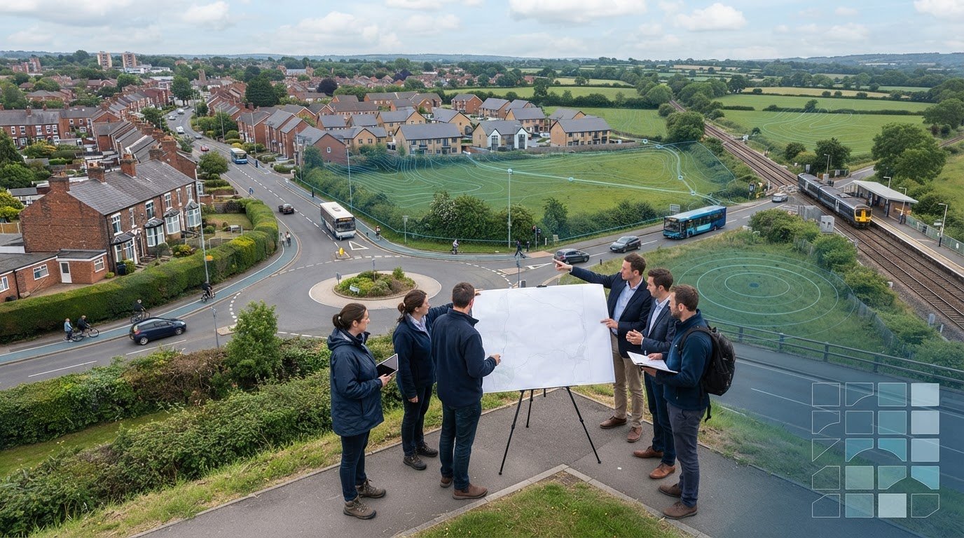
    A site can look deliverable on a map and still present transport constraints that only emerge later. A transport assessment for site allocation helps local planning authorities test whether a location could support planned growth. It is not simply a project-level Transport Assessment prepared early: its purpose is to compare potential locations and identify issues that may need further investigation.

    Before a site enters a Local Plan, decision-makers need a proportionate view of access, network capacity and sustainable travel opportunities. The evidence should be detailed enough to reveal key constraints, compare locations and consider whether realistic measures could help address issues. It should not imply that every detail of a future development is already known.

    In England, the NPPF published on 17 August 2026 introduced a vision-led approach to transport planning and requires the Department for Transport’s Connectivity Tool to inform site selection. These inputs can strengthen the evidence base, but they should be considered alongside local knowledge and the quality of walking, cycling and public transport connections.

    This article explains what transport evidence can establish, which questions to investigate when assessing a site, and how surveys and proportionate analysis can identify issues early. The aim is a clearer, more realistic basis for planning sustainable growth.

    Key Takeaways

    • A transport assessment for site allocation should answer a defined plan-making question. It is not a project-level Transport Assessment or a guarantee of permission.
    • Build a site baseline covering highway access, public transport, walking and cycling connections, and the evidence available for each.
    • Use consistent criteria to compare access, travel choices, network effects, deliverability and uncertainty across candidate sites.
    • Follow a clear sequence: define the plan questions, assemble evidence, assess sites, test implications and report findings.
    • Make assumptions and evidence gaps visible so decision-makers can identify where further investigation may be needed as plans progress.

    What does transport evidence for local plan site allocation actually assess?

    Transport evidence for potential Local Plan allocations tests the transport implications and opportunities of development at each location. A transport assessment for site allocation helps decision-makers consider whether growth could be accommodated accessibly and safely, and whether realistic transport measures could address identified constraints. It informs plan-making; it does not grant planning permission or guarantee that a site will be allocated.

    The practical question is whether a site could support the planned scale and type of growth in its local context. Answering it means looking beyond vehicle movements to access, connections and opportunities to support sustainable travel. This broader process sits within Transport planning, where transport choices and land use are considered together.

    The video below demonstrates a transport-zone allocation tutorial, offering a related illustration of how locations can be organised for planning analysis.

    How transport evidence informs local plan decisions

    Evidence gives the local planning authority a consistent basis for comparing candidate sites against the plan’s objectives and transport considerations. It can show how locations differ in access to the highway network, public transport and everyday destinations, and highlight where growth could put pressure on local networks. Findings inform professional judgement alongside other planning evidence and policy. Transport analysis is one part of the decision, not a verdict on its own.

    The local planning and highway authority context shapes the questions, information available and level of analysis. Local network conditions and planned transport improvements matter, so the evidence should state its assumptions and limits instead of implying certainty where development details are still emerging.

    Site allocation evidence versus a Transport Assessment

    Site allocation evidence is strategic and comparative. It helps establish whether a location appears suitable for planned growth and identifies matters that may need further work. A development-specific Transport Assessment examines a defined proposal in greater detail, using its particular land use, scale, access arrangements and expected travel patterns.

    The scope should match the plan stage, information available and characteristics of each site. Early analysis may identify a potential access constraint or a need to investigate sustainable connections, but it will not necessarily resolve detailed design or operational questions for a future application. For a closer look at project-level reporting, see this Transport Assessment London guide.

    Which transport issues should a local plan site assessment examine?

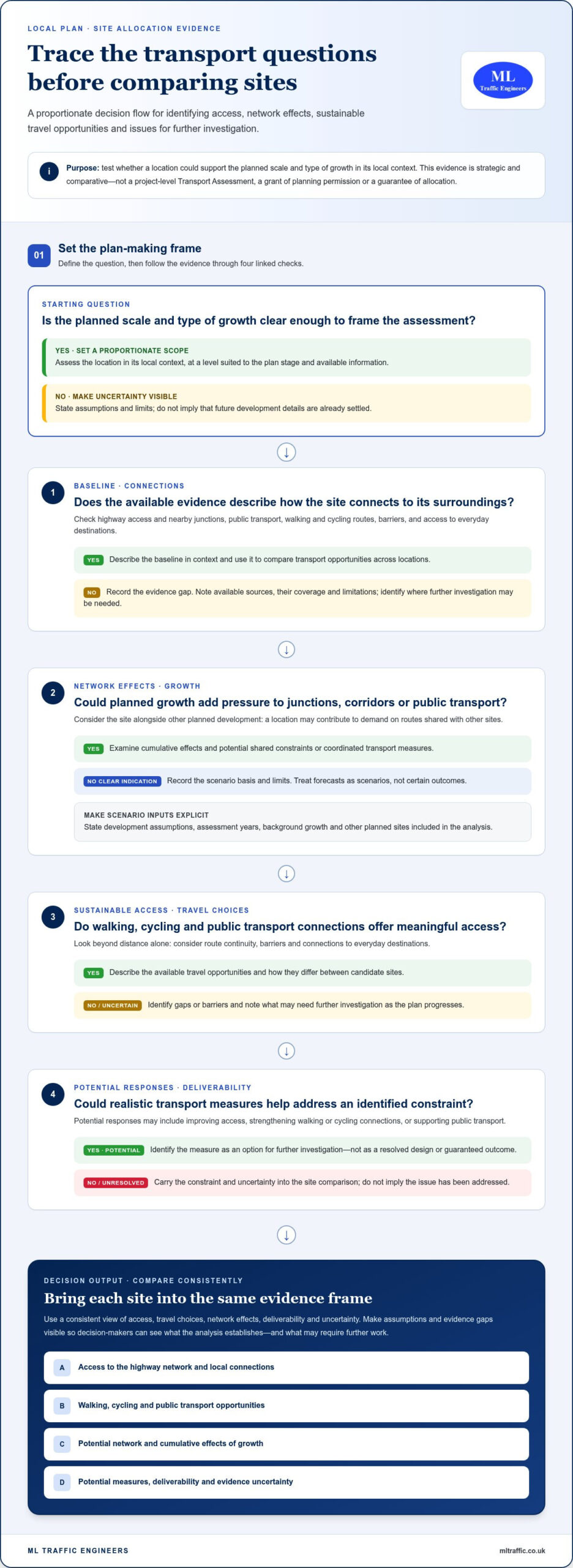
    A useful assessment connects a site’s existing transport conditions with the demands and opportunities that new development could bring. It should examine four linked questions: what networks are in place, how growth may affect them, how people could reach the site, and what potential responses warrant further investigation.

    The level of detail should fit the plan stage and the evidence available. The UK guidance on transport evidence provides a framework for building an evidence base to support Local Plan preparation. In practice, clearly stated assumptions and data limitations help decision-makers understand what the analysis can and cannot establish.

    Baseline conditions and sustainable access

    Start by mapping the site’s connections to its surroundings. Review access to the highway network, nearby junctions, public transport services, walking routes and cycling connections. Consider route continuity, barriers and access to everyday destinations rather than relying on distance alone. A rural site, an urban infill location and an edge-of-town allocation may have very different transport opportunities.

    Local transport strategies and available traffic or parking surveys can help establish the baseline. Record each source, its date and coverage, then identify gaps that may need further investigation. The aim is to describe how the network functions in context, not to assume every future resident or employee will travel in the same way.

    Capacity, forecast demand and cumulative impacts

    Consider how proposed growth could affect junctions, corridors and public transport over time. A site may appear manageable on its own but contribute to demand on routes that also serve other planned development. Assessing cumulative effects can reveal shared constraints and opportunities for coordinated transport measures.

    Forecasts are scenarios, not certain outcomes. State the development assumptions, assessment years, background growth and other planned sites included in the analysis. If the methodology uses TRICS, explain why the selected comparison data is suitable and ensure the inputs are current and applied appropriately. Avoid suggesting more precision than the evidence supports, particularly when the allocation’s scale or delivery details remain unsettled.

    Potential responses might include improving access, strengthening walking or cycling connections, or supporting public transport. At plan stage, identify these as options for investigation and make dependencies or uncertainties clear. This helps focus follow-up evidence as the plan develops. ML Traffic Engineers UK’s transport assessment and survey work can help present transport evidence clearly for planning decisions.

    How do planners compare transport evidence across candidate sites?

    A fair comparison needs common questions and consistent evidence, not a single headline measure such as predicted traffic. A transport assessment for site allocation should show how each candidate performs across access, travel choices, network effects, deliverability and uncertainty. This makes differences visible without suggesting that transport evidence alone determines which sites a Local Plan should allocate.

    Set the comparison criteria before reviewing individual sites. Apply the same framework to each location, while explaining material differences in context, scale or available evidence. A site with strong public transport access may face a different constraint from one that depends on a highway improvement. Consistency means asking the same questions, not forcing every location into identical conclusions.

    Build a proportionate site comparison framework

    Use shared questions to organise the evidence. Separate measurable findings, such as observed traffic conditions or proximity to transport services, from qualitative planning considerations, such as whether routes provide coherent connections. Explain the basis for each finding, and do not present a qualitative judgement as if it had the precision of a measured result.

    A concise matrix can help decision-makers review the evidence side by side:

    • Access: What routes connect the site to the network, and are there known constraints?
    • Mode choice: What practical opportunities exist for walking, cycling and public transport?
    • Network effects: Which junctions, corridors or services could be affected by planned growth?
    • Deliverability: What transport measures may be needed, and what dependencies could affect them?
    • Evidence and uncertainty: What information supports the assessment, and where are the gaps or assumptions?

    For each criterion, summarise strengths, constraints, evidence gaps and potential responses. This helps distinguish a known issue from a question that needs investigation, rather than reducing a complex assessment to a simple score or rank.

    Interpret uncertainty and mitigation fairly

    State assumptions consistently across sites. These may include the scale or timing of growth, background traffic conditions, planned development nearby and the availability of survey data. If information differs in age, coverage or reliability, explain how that affects the comparison. Do not use uncertainty to overstate a constraint or dismiss it because the evidence is incomplete.

    Describe potential mitigation carefully. An access change or public transport improvement may be an option for further consideration, but should not be presented as committed or funded unless that status is established. Record dependencies, such as coordination with another scheme, so decision-makers can distinguish a potential response from an unresolved requirement.

    The comparison informs wider planning judgement alongside policy and other evidence. Its value is in showing what is known, what remains uncertain and how those factors differ between sites, giving the local planning authority a clearer basis for its overall assessment.
    Transport Assessments for Site Allocation: Building a Local Plan Evidence Base

    How should transport evidence be developed for a local plan?

    A clear process keeps a transport assessment for site allocation focused on the decisions the plan needs to make. Scope the work to the plan stage, candidate sites and information available. Do not assume every location needs the same surveys or modelling.

    From plan questions to a transparent evidence base

    Begin by identifying the allocation options, policy questions and decision stage the evidence must support. Early engagement with the relevant local planning and highway authorities, where appropriate, can clarify local priorities, available network information and issues that need attention.

    Then work through the evidence in sequence:

    • 1. Define the questions. Set out what decision-makers need to understand about each site and the planned scale of growth.
    • 2. Assemble existing information. Review relevant local transport strategies, network data, authority material and available traffic or parking surveys.
    • 3. Assess each site. Examine its context and transport opportunities using a consistent, site-appropriate approach.
    • 4. Test implications. Consider whether further survey work, modelling or specialist analysis is needed to understand a particular constraint or uncertainty.
    • 5. Report findings. Present conclusions, assumptions, limitations and possible next steps in a format that supports plan-making.

    Not every allocation needs new traffic counts, parking surveys or modelling. Existing information may be sufficient for an early comparison, while a site with a complex access issue or possible cumulative effects may warrant further investigation. Record each dataset’s source and date, whether it needs updating, and why the chosen scope is suitable. This makes the evidence traceable and keeps the analysis proportionate to the plan stage.

    Reporting findings and next-stage requirements

    Summarise each site’s transport opportunities, constraints and evidence limitations in plain language. Separate observed conditions from assumptions and explain what the analysis can reasonably conclude. If information is incomplete, identify the gap rather than presenting an estimate as a settled outcome.

    Some matters may need more detailed assessment if a site progresses to a planning application, such as proposal-specific travel demand, access arrangements or junction operation. Explain what further evidence may be needed and why, while keeping plan-making conclusions distinct from project-level assessment.

    ML Traffic Engineers provides transport planning and assessment services, including technical reports, traffic surveys and parking surveys, to support development planning.

    Explore ML Traffic Engineers’ transport planning services.

    What makes transport evidence useful for site allocation decisions?

    Useful evidence is proportionate to the plan stage, transparent about its methods and limitations, grounded in local conditions, and tied to a clear planning question. A transport assessment for site allocation can inform decisions, but no single report replaces the wider Local Plan evidence base or the planning judgement needed to weigh transport alongside other considerations.

    A practical quality check for transport evidence

    Before relying on the findings, check that the assessment answers the question it was commissioned to address. Its methods should be explained, and its conclusions should not exceed what the evidence can support. A useful review covers:

    • Scope: Does the work match the plan stage, proposed allocation and decision required?
    • Baseline: Does it represent relevant local transport conditions and authority context accurately?
    • Assumptions: Are data sources, dates, growth scenarios and limitations clear?
    • Site comparison: Have candidate locations been assessed consistently, while recognising meaningful differences?
    • Follow-up: Are potential responses and matters for later, more detailed assessment identified?

    Look for a clear connection between an identified constraint, the evidence behind it and any possible mitigation. The report should distinguish an option for further investigation from an improvement that is committed or funded. It should also identify incomplete information, so uncertainty is not mistaken for proof of a problem or used to dismiss one.

    Where specialist transport planning support fits

    Specialist input can help define and address a specific evidence need. Depending on the site and question, a tailored Transport Assessment or traffic or parking survey may clarify existing conditions, assess a proposal or support development planning. The scope depends on the purpose, available information and local context. This work supports informed decisions but cannot guarantee site allocation or planning consent.

    For project-level assessment and reporting, read the transport assessment for development planning guide. ML Traffic Engineers prepares technical reports and undertakes traffic and parking analysis to make transport evidence clear and useful to planning decisions.

    If you’re developing evidence for a site or proposal, review ML Traffic Engineers’ transport assessment services.

    Build a clearer evidence base for your next development decision

    A sound transport assessment for site allocation is proportionate to the plan stage, grounded in local conditions and clear about its assumptions. Comparing sites across access, sustainable travel, network effects and deliverability gives decision-makers a more balanced view than relying on a single traffic measure. Transport evidence informs wider planning judgement; it does not decide allocation or guarantee consent.

    For development planning, ML Traffic Engineers prepares Transport Assessments, Transport Statements and Travel Plans, supported by traffic and parking surveys where relevant. The consultancy works across Greater London, Manchester, Birmingham, the West Midlands, Liverpool, Surrey, East Sussex, West Sussex, Hampshire, Berkshire and Buckinghamshire.

    Discuss transport evidence for your development project with ML Traffic Engineers. Clear, well-scoped analysis is a practical step towards informed planning decisions.

    Frequently Asked Questions

    What is a transport assessment for site allocation?

    A transport assessment for site allocation is proportionate evidence used to understand the transport implications and opportunities of a potential Local Plan site. It can examine access, public transport, walking and cycling connections, likely network effects and possible responses to constraints. The findings help the local planning authority compare sites and inform plan-making alongside other evidence. They do not grant planning permission or guarantee that a site will be allocated.

    Is a Transport Assessment required for every local plan site allocation?

    No single level of detailed Transport Assessment is automatically appropriate for every candidate site. The evidence needed depends on the plan stage, location, proposed scale of growth, known transport issues and available data. Some sites may be assessed using existing information, while others may need surveys or further analysis. The local planning and highway authority context helps shape the scope, which should be tied to the specific plan-making question.

    How does a Transport Assessment differ from a local plan transport evidence base?

    A local plan transport evidence base supports strategic decisions across potential allocations, often comparing several locations at a broad level. A development Transport Assessment examines a defined proposal in more detail, including its particular land use, scale, access and expected travel patterns. Plan evidence can identify constraints and topics for later investigation, but it does not replace project-specific assessment where that is needed to inform a planning application.

    What transport factors are considered when allocating a site?

    Assessment may consider access to the highway network, junction and corridor conditions, public transport provision, walking routes, cycling connections and access to everyday services. It can also examine the potential effects of planned growth, including cumulative demand from nearby development, and identify possible transport responses. The appropriate factors depend on the site and local context. Evidence should explain its assumptions and limitations so decision-makers can interpret findings fairly.

    Can a transport assessment guarantee that a site will be allocated?

    No. A Transport Assessment provides evidence to inform planning judgement; it cannot guarantee allocation or planning permission. Local planning authorities consider transport findings alongside other evidence, policy and plan objectives. A clear assessment can identify opportunities, constraints and further work that may be needed, helping decision-makers understand a site’s transport implications. Its conclusions should remain within the limits of the data and assumptions used.

    When should transport evidence be prepared for a local plan?

    Prepare transport evidence early enough to inform the consideration and comparison of potential sites, rather than waiting until transport constraints emerge late in plan preparation. Start by defining the questions the plan needs to answer, then review available strategies, network information and surveys. Where information is incomplete or a potential issue needs closer examination, proportionate additional data or analysis can help clarify it while options are still being considered.

    Does site allocation transport evidence replace a development Transport Assessment?

    No. Site allocation evidence considers a location strategically, while a development Transport Assessment addresses a specific proposal and its detailed characteristics. Later work may need to examine proposal-specific travel demand, access arrangements or network operation. ML Traffic Engineers prepares Transport Assessments, Transport Statements, Travel Plans, and traffic and parking surveys for development planning projects in Greater London, Manchester, Birmingham, the West Midlands, Liverpool, Surrey, East Sussex, West Sussex, Hampshire, Berkshire and Buckinghamshire.

    Michael Lee

    Article by

    Michael Lee

    Transport planner with over 35 years' experience.

    Disclaimer

    The content on mltraffic.co.uk, including all technical articles, guides, and resources, is provided for general informational and educational purposes only. It is not intended to constitute professional advice in traffic engineering, transportation planning, development approvals, or any other technical or legal field.
    While ML Traffic Engineers makes every reasonable effort to ensure the accuracy, completeness, and timeliness of the information published, we do not provide any warranties or representations (express or implied) regarding its reliability, suitability, or availability for any particular purpose. Any reliance you place on the content is strictly at your own risk.
    In no event shall ML Traffic Engineers, its directors, employees, authors, or affiliates be liable for any direct, indirect, incidental, special, consequential, or punitive damages (including, without limitation, loss of profits, data, or business opportunities) arising out of or in connection with the use of, or inability to use, any information provided on this website.
    The articles and guides on this site are not a substitute for engaging a qualified, professional traffic engineer to assess your specific project requirements. For tailored advice, compliance assessments, or traffic engineering services, please contact a competent professional.
    This disclaimer may be updated from time to time without notice. By accessing or using this website, you agree to be bound by the most current version of this disclaimer.

  • Transport Planning Consultants Wandsworth: The 2026 Developer’s Guide to Planning Approval

    Transport Planning Consultants Wandsworth: The 2026 Developer’s Guide to Planning Approval

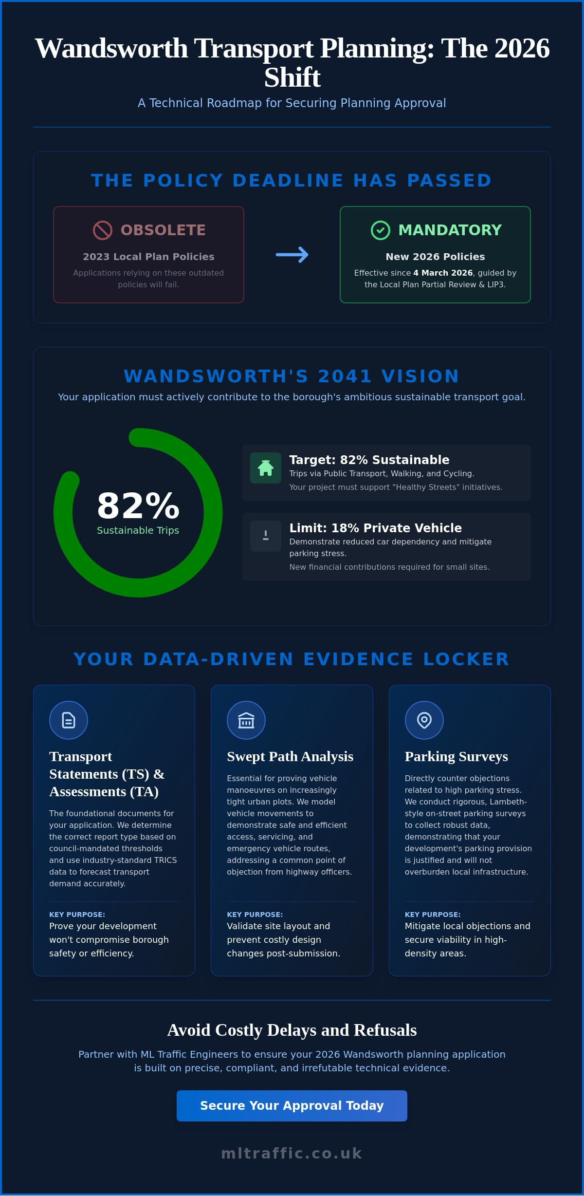
    Your 2026 planning application in Wandsworth will fail if it relies on the 2023 Local Plan policies that were superseded on 4 March 2026. Partnering with expert Transport Planning Consultants Wandsworth ensures your project aligns with the six new planning policies that now dictate borough development. With the council’s aggressive target of 82% sustainable trips by 2041 and the new financial contribution requirements for small sites, the margin for technical error has disappeared.

    You’re likely already feeling the pressure of high parking stress areas and the difficulty of proving vehicle manoeuvres on increasingly tight urban plots. It’s a high-stakes environment where a single oversight in a technical report can lead to costly delays or outright refusal. This guide provides the technical roadmap you need to navigate these complexities, focusing on data-driven reports that satisfy highway officers and accelerate your approval timeline. We’ll break down the specific roles of Transport Statements, Swept Path Analysis, and Parking Surveys in securing a successful decision under the latest 2026 regulations.

    Key Takeaways

    • Understand how the 2026 Wandsworth Local Plan Partial Review and LIP3 policies dictate the technical evidence required for your planning application.
    • Identify whether your project triggers the need for a Transport Statement or a full Transport Assessment based on specific council-mandated thresholds.
    • Secure your site’s viability by using Transport Planning Consultants Wandsworth to conduct Lambeth-style Parking Surveys and Swept Path Analysis to mitigate local parking stress objections.
    • Learn how to navigate the pre-application process to align your technical reports with the council’s 82% sustainable transport target for 2041.
    • Avoid common regulatory pitfalls by ensuring all technical documentation meets the latest legislative benchmarks and industry standards for precision.

    Wandsworth Transport Planning: Navigating Local Policy in 2026

    Wandsworth’s planning environment underwent a significant shift on 4 March 2026 with the adoption of the Local Plan Partial Review. For developers, this means that generic transport strategies are no longer sufficient. Transport Planning Consultants Wandsworth provide the technical rigour required to navigate the Third Local Implementation Plan (LIP3), which is the primary document setting the framework for all borough infrastructure. This transportation planning process ensures that new developments don’t just exist in isolation but actively contribute to the borough’s vision for “Healthy Streets.”

    The council now demands exhaustive transport evidence for even minor developments. This isn’t just bureaucratic red tape; it’s a direct response to the borough’s ambitious target to have 82% of all trips made via public transport or active travel by 2041. Whether you’re proposing a single dwellinghouse or a multi-unit scheme, your application must demonstrate how it supports walking, cycling, and reduced car dependency. A consultant acts as the vital bridge, translating your commercial development goals into technical reports that satisfy strict council criteria.

    For developers who require professional property valuations or building surveys to complement their transport strategy, check out South Surveyors for expert assistance in the South London area.

    To better understand the technical distinctions in this field, watch this helpful video:

    The Role of the Local Implementation Plan (LIP)

    The LIP3 is the primary tool Wandsworth uses to deliver the Mayor of London’s Transport Strategy at a local level. Planning decisions are heavily influenced by how well a project addresses specific LIP objectives, such as air quality improvements on Putney High Street or congestion relief around Clapham Junction. If your project doesn’t explicitly align with the council’s walking and cycling strategies, you risk an immediate objection from highway officers. We ensure your submission highlights these alignments through robust data and clear policy mapping, moving your project from initial assessment to execution without unnecessary delays.

    Why Local Expertise Matters in Wandsworth

    Wandsworth’s requirements often differ significantly from neighbouring boroughs like Lambeth or Merton. For instance, the high-density constraints in Battersea require a specific understanding of local highway network pressures that a generalist might overlook. ML Traffic Engineers bring over a decade of experience to Wandsworth projects, ensuring that every Transport Statement or Parking Survey is tailored to these hyper-local nuances. Our team manages the full project lifecycle, providing the technical authority needed to reduce regulatory pressure on your team. We understand the intricate regional regulations so that you don’t have to, maintaining a standard of formal excellence that aligns with the borough’s strict regulatory environment.

    Essential Technical Reports: Transport Statements & Assessments

    Securing planning approval in 2026 requires precise technical documentation that leaves no room for ambiguity. Transport Planning Consultants Wandsworth ensure that your data withstands the rigorous scrutiny of highway officers. The foundation of a successful application lies in choosing the correct report type, whether it’s a Transport Statement (TS) or a full Transport Assessment (TA). These documents must align with Wandsworth’s Local Implementation Plan to prove your development won’t compromise the borough’s safety or efficiency standards.

    Accuracy in these reports is driven by the TRICS database, the industry standard for trip generation analysis. We use this data-driven approach to predict how many people will enter and leave your site by various modes of travel. By comparing your site against similar established developments, we provide a realistic forecast of transport demand. This level of technical authority is essential for justifying your project’s impact on the local network. If your data is flawed, your application will likely face immediate pushback from the council.

    When Do You Need a Transport Statement?

    A Transport Statement is a simplified report for developments with limited transport impact. In Wandsworth, this typically applies to non-major applications that could still influence local traffic or parking. While the council doesn’t set a universal unit threshold, any development that changes the use of a site or introduces new residents often triggers this requirement. We focus on clarity and speed, ensuring these reports address local highway concerns without unnecessary complexity. If you’re unsure which report your site needs, our technical reporting services can provide immediate clarity.

    Full Transport Assessments for Major Developments

    Major developments require a comprehensive Transport Assessment. These reports go beyond simple trip counts to include detailed junction capacity modelling and multi-modal impact analysis. In high-growth areas like the Nine Elms regeneration zone, the council demands a focus on the cumulative impact of multiple projects. A TA must demonstrate how your site integrates with existing infrastructure while supporting the borough’s active travel goals. For a deeper look at these requirements, see our Transport Assessment London Guide. We manage this entire technical process, from initial scoping with highway officers to final submission, ensuring your project remains on track for approval.

    Transport Planning Consultants Wandsworth: The 2026 Developer’s Guide to Planning Approval

    Data-Driven Solutions: Parking Surveys and Swept Path Analysis

    Parking provision remains the most frequent point of contention for planning applications in South West London. In many cases, it’s the primary reason for a project’s refusal. To overcome local objections, Transport Planning Consultants Wandsworth must provide robust, empirical evidence that proves a development won’t saturate the local highway network. By utilizing precise data collection methods, we help you navigate the borough’s strict requirements and secure the necessary approvals for your site.

    The foundation of a successful parking strategy involves a comprehensive understanding of Wandsworth Council’s transport policy. This policy prioritizes active travel and public transport, meaning any proposal for on-site parking must be rigorously justified. We use high-precision data to demonstrate that your development aligns with the council’s vision for reduced car dependency while still meeting the functional needs of future residents or commercial tenants.

    Justifying Parking with PTAL and Stress Surveys

    The Public Transport Accessibility Level (PTAL) system is the primary tool used to determine how much parking a site is allowed. Areas with high PTAL ratings, such as Putney or Battersea, often require “car-free” or “car-capped” developments. If your site is in a high-stress area, we conduct Lambeth-style parking surveys. This methodology involves counting parked cars within a 200-metre walking distance of the site over two consecutive weekday nights. This data is essential for residential conversions where you need to prove that any overspill parking can be safely absorbed by the existing streets without creating a hazard.

    Swept Path Analysis: Ensuring Vehicle Maneuverability

    Swept Path Analysis (SPA) is a technical simulation used to track the path of a vehicle as it manoeuvres through a site. It’s a non-negotiable requirement for proving that refuse freighters and fire tenders can access your development safely, especially on narrow Wandsworth streets. By using advanced software, we simulate these movements during the design phase to prevent costly redesigns of site entrances or basement car park layouts. This precision ensures your site is functional from day one. For more information on how we manage these technical requirements, explore our Swept Path Analysis Services. We focus on providing the technical authority needed to satisfy highway officers and move your project forward.

    Securing Approval: Dealing with Wandsworth Council and TfL

    Dealing with Wandsworth Council requires a proactive and highly technical approach. In 2026, the local planning landscape is more stringent than ever following the adoption of the Local Plan Partial Review. Engaging Transport Planning Consultants Wandsworth early in the project lifecycle allows you to address potential highway objections before they crystallize into a formal refusal. For major residential developments exceeding 25 units, the council’s pre-application advice fee for the 2026/2027 period is £5,240.00. While this is an upfront cost, it’s a vital investment to secure an agreement on your transport strategy before the final submission.

    Common pitfalls often involve insufficient data regarding trip generation or failing to align with the borough’s 82% sustainable travel target. If your site sits near the Strategic Road Network (SRN), such as the A3 or A205 South Circular, Transport for London (TfL) will also act as a statutory consultee. We manage these dual-layered negotiations, ensuring that both borough and regional requirements are met. This prevents conflicting demands from stalling your progress and ensures your technical reports satisfy all regulatory bodies simultaneously.

    The Pre-Application Process

    Early engagement with Wandsworth highway engineers is the most effective way to mitigate risk. By agreeing on the scope of your Transport Assessment or Parking Survey during the pre-app stage, you avoid the cost of re-running surveys if the council later disputes your methodology. This stage also provides a formal platform to address community concerns regarding traffic volume. We present clear, data-driven evidence to reassure both officers and local residents that your project is viable and safe. We take pride in our precision, ensuring every report adheres to the latest legislative benchmarks.

    Navigating Section 278 and Section 38 Agreements

    Planning approval is only the first hurdle in the infrastructure lifecycle. If your development requires changes to the public highway, such as a new site entrance or pavement widening, you must enter into a Section 278 agreement. This legal contract ensures that all works meet the borough’s safety and engineering standards. Our team manages the technical audit process, providing the detailed drawings and specifications required for council approval. For a comprehensive breakdown of these requirements, read our Highway Design S278 & S38 Guide. If you’re ready to move from planning to implementation, contact our technical team to discuss your project’s specific highway requirements.

    Expert Transport Planning Consultants in Wandsworth: The ML Traffic Advantage

    ML Traffic Engineers provides the technical precision required for developers to navigate the 2026 Wandsworth Local Plan Partial Review. With over 10 years of experience in London transport planning, we understand that accuracy is a functional necessity in this high-stakes environment. Our team balances technical authority with a client-focused approach to reduce the regulatory pressure on your development team. We position ourselves as a dependable, highly organized partner that understands intricate regional regulations so you don’t have to. This expertise is vital for ensuring your project aligns with the borough’s latest safety and sustainability benchmarks.

    We maintain a sense of readiness and urgency that aligns with the fast-moving nature of infrastructure development. This constant availability ensures that your planning deadlines are met with professional integrity. Our commitment to precision and adherence to standards acts as a primary hallmark of our brand promise. We view our role not just as a service provider, but as a vital guardian of professional standards in the borough, ensuring every report we produce is robust and defensible.

    Our Comprehensive Service Offering

    Our team manages the full project lifecycle, from inception to completion. We deliver a suite of technical reports tailored to the unique constraints of South West London sites. Whether your project requires initial Traffic Surveys to establish a baseline or complex Travel Plans to meet sustainability targets, we provide the data-driven analysis needed for approval. We also specialize in technical documentation for residential and commercial developments, including:

    • Detailed Transport Statements and Transport Assessments.
    • Lambeth-style Parking Surveys to address local parking stress.
    • High-precision Swept Path Analysis for tight urban sites.

    For a full breakdown of our technical capabilities, visit What We Do. We provide an all-encompassing, fully-managed service that ensures consistency across all your planning documents, reducing the risk of conflicting data that could trigger a council objection.

    Partnering for Planning Success

    We recognize that the 2026 planning environment in Wandsworth is more demanding than ever. The council’s shift toward social rent and sustainable transport targets means your technical evidence must be beyond reproach. Partnering with expert Transport Planning Consultants Wandsworth gives you the technical authority needed to satisfy highway officers and local stakeholders alike. We provide reliable data collection that stands up to the most rigorous council scrutiny, ensuring your project moves forward without delay.

    Our all-encompassing approach means we handle the logistical complexities of data collection and report writing so your team can focus on the broader development goals. We take pride in our rapid response capabilities and our ability to manage unpredictable infrastructure requirements. If you need a partner that values time and precision, get a transport planning quote for your Wandsworth project today. We’re ready to provide the professional support your development requires to secure planning approval in 2026.

    Maximise Your Development Potential in Wandsworth

    Success in the 2026 planning cycle depends on aligning your project with the borough’s updated Local Plan and LIP3 targets. We’ve explored how data-driven reports, from Lambeth-style parking surveys to rigorous transport assessments, provide the technical foundation needed to satisfy highway officers. Precision in these documents is not optional; it’s a functional requirement for any developer looking to mitigate risk and avoid costly redesigns.

    Since 2014, ML Traffic Engineers has provided over a decade of London expertise to help clients navigate these intricate regional regulations. As specialist Transport Planning Consultants Wandsworth, we offer a comprehensive service that manages everything from initial traffic surveys to complex swept path analysis and TRICS-based reporting. We take pride in our precision and readiness to meet urgent planning deadlines.

    Don’t let regulatory complexity stall your progress. Contact ML Traffic Engineers for expert Wandsworth transport planning advice and ensure your technical evidence stands up to the highest standards of scrutiny. Your project’s approval is within reach with the right technical partner by your side.

    Frequently Asked Questions

    Do I need a Transport Statement for a small development in Wandsworth?

    Yes, Wandsworth Council often requires a Transport Statement for non-major developments that could impact local highway safety or parking. Even a small residential conversion must demonstrate how it aligns with the borough’s latest sustainable travel targets and LIP3 policies. We provide these simplified reports to ensure your project meets the necessary technical criteria without unnecessary complexity.

    What is a Lambeth Methodology parking survey and why is it used in Wandsworth?

    A Lambeth Methodology survey is the industry standard for measuring parking stress in London boroughs. It involves counting parked vehicles within a 200-metre radius of a site over two separate weekday nights between 00:30 and 05:30. Wandsworth highway officers require this data to prove that any overspill parking from your development won’t saturate the existing street network.

    How much does a transport planning consultant cost in London?

    Fees for transport planning services depend entirely on the scale of the project and the specific reports required by the council. A complex Transport Assessment for a major development involves more technical modelling than a standard Parking Survey for a single unit. You should contact a specialist firm directly to receive a tailored quote based on your site’s specific requirements.

    Can you help with Swept Path Analysis for fire tender access?

    Yes, we provide high-precision Swept Path Analysis to simulate the movement of emergency vehicles. This technical data is a non-negotiable requirement for proving that fire tenders and refuse freighters can safely manoeuvre through your site. By simulating these paths during the design phase, we help you avoid the risk of a planning refusal based on poor site accessibility.

    What is a PTAL rating and how does it affect my planning application?

    PTAL stands for Public Transport Accessibility Level and measures a site’s proximity to public transport networks. Ratings range from 0 to 6b, with higher scores indicating better access. Your PTAL rating directly dictates how much on-site parking the council will allow, with high-scoring areas like Putney or Battersea often requiring car-free or car-capped developments.

    How long does it take to prepare a Transport Assessment for Wandsworth Council?

    The timeline for a full Transport Assessment varies based on the level of data collection required, such as multi-modal traffic surveys or junction modelling. While we maintain a sense of urgency to meet planning deadlines, the process usually takes several weeks to ensure all technical evidence is robust. Early engagement during the pre-application stage helps streamline this process significantly.

    Does Wandsworth Council allow car-free developments?

    Wandsworth actively encourages car-free developments in areas with high public transport accessibility. This approach aligns with the council’s target for 82% of all trips to be made by public transport or active travel by 2041. To secure approval for a car-free scheme, you must provide a solid technical justification through a Travel Plan and a detailed Transport Statement.

    What happens if my planning application is refused on transport grounds?

    If your application is refused, you have the option to appeal the decision or resubmit with revised technical evidence. Expert Transport Planning Consultants Wandsworth can review the council’s decision notice and identify the specific data gaps that led to the refusal. We then produce the necessary Parking Surveys or technical reports to address the highway officer’s objections and improve your chances of success upon resubmission.

    Michael Lee

    Article by

    Michael Lee

    Transport planner with over 35 years’ experience.

    Disclaimer

    The content on mltraffic.co.uk, including all technical articles, guides, and resources, is provided for general informational and educational purposes only. It is not intended to constitute professional advice in traffic engineering, transportation planning, development approvals, or any other technical or legal field.
    While ML Traffic Engineers makes every reasonable effort to ensure the accuracy, completeness, and timeliness of the information published, we do not provide any warranties or representations (express or implied) regarding its reliability, suitability, or availability for any particular purpose. Any reliance you place on the content is strictly at your own risk.
    In no event shall ML Traffic Engineers, its directors, employees, authors, or affiliates be liable for any direct, indirect, incidental, special, consequential, or punitive damages (including, without limitation, loss of profits, data, or business opportunities) arising out of or in connection with the use of, or inability to use, any information provided on this website.
    The articles and guides on this site are not a substitute for engaging a qualified, professional traffic engineer to assess your specific project requirements. For tailored advice, compliance assessments, or traffic engineering services, please contact a competent professional.
    This disclaimer may be updated from time to time without notice. By accessing or using this website, you agree to be bound by the most current version of this disclaimer.