
A site can look deliverable on a map and still present transport constraints that only emerge later. A transport assessment for site allocation helps local planning authorities test whether a location could support planned growth. It is not simply a project-level Transport Assessment prepared early: its purpose is to compare potential locations and identify issues that may need further investigation.
Before a site enters a Local Plan, decision-makers need a proportionate view of access, network capacity and sustainable travel opportunities. The evidence should be detailed enough to reveal key constraints, compare locations and consider whether realistic measures could help address issues. It should not imply that every detail of a future development is already known.
In England, the NPPF published on 17 August 2026 introduced a vision-led approach to transport planning and requires the Department for Transport’s Connectivity Tool to inform site selection. These inputs can strengthen the evidence base, but they should be considered alongside local knowledge and the quality of walking, cycling and public transport connections.
This article explains what transport evidence can establish, which questions to investigate when assessing a site, and how surveys and proportionate analysis can identify issues early. The aim is a clearer, more realistic basis for planning sustainable growth.
Key Takeaways
- A transport assessment for site allocation should answer a defined plan-making question. It is not a project-level Transport Assessment or a guarantee of permission.
- Build a site baseline covering highway access, public transport, walking and cycling connections, and the evidence available for each.
- Use consistent criteria to compare access, travel choices, network effects, deliverability and uncertainty across candidate sites.
- Follow a clear sequence: define the plan questions, assemble evidence, assess sites, test implications and report findings.
- Make assumptions and evidence gaps visible so decision-makers can identify where further investigation may be needed as plans progress.
What does transport evidence for local plan site allocation actually assess?
Transport evidence for potential Local Plan allocations tests the transport implications and opportunities of development at each location. A transport assessment for site allocation helps decision-makers consider whether growth could be accommodated accessibly and safely, and whether realistic transport measures could address identified constraints. It informs plan-making; it does not grant planning permission or guarantee that a site will be allocated.
The practical question is whether a site could support the planned scale and type of growth in its local context. Answering it means looking beyond vehicle movements to access, connections and opportunities to support sustainable travel. This broader process sits within Transport planning, where transport choices and land use are considered together.
The video below demonstrates a transport-zone allocation tutorial, offering a related illustration of how locations can be organised for planning analysis.
How transport evidence informs local plan decisions
Evidence gives the local planning authority a consistent basis for comparing candidate sites against the plan’s objectives and transport considerations. It can show how locations differ in access to the highway network, public transport and everyday destinations, and highlight where growth could put pressure on local networks. Findings inform professional judgement alongside other planning evidence and policy. Transport analysis is one part of the decision, not a verdict on its own.
The local planning and highway authority context shapes the questions, information available and level of analysis. Local network conditions and planned transport improvements matter, so the evidence should state its assumptions and limits instead of implying certainty where development details are still emerging.
Site allocation evidence versus a Transport Assessment
Site allocation evidence is strategic and comparative. It helps establish whether a location appears suitable for planned growth and identifies matters that may need further work. A development-specific Transport Assessment examines a defined proposal in greater detail, using its particular land use, scale, access arrangements and expected travel patterns.
The scope should match the plan stage, information available and characteristics of each site. Early analysis may identify a potential access constraint or a need to investigate sustainable connections, but it will not necessarily resolve detailed design or operational questions for a future application. For a closer look at project-level reporting, see this Transport Assessment London guide.
Which transport issues should a local plan site assessment examine?
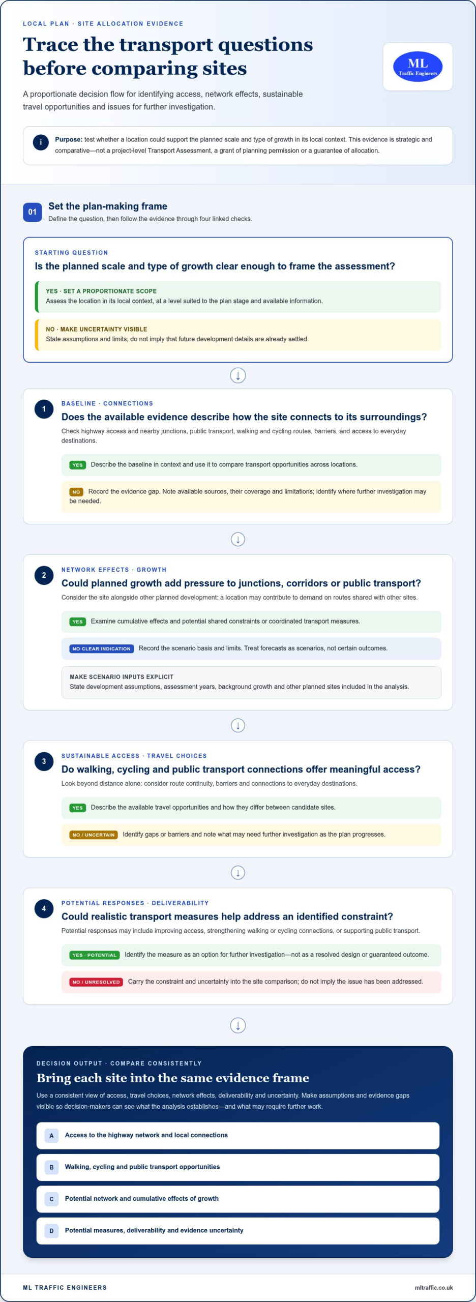
A useful assessment connects a site’s existing transport conditions with the demands and opportunities that new development could bring. It should examine four linked questions: what networks are in place, how growth may affect them, how people could reach the site, and what potential responses warrant further investigation.
The level of detail should fit the plan stage and the evidence available. The UK guidance on transport evidence provides a framework for building an evidence base to support Local Plan preparation. In practice, clearly stated assumptions and data limitations help decision-makers understand what the analysis can and cannot establish.
Baseline conditions and sustainable access
Start by mapping the site’s connections to its surroundings. Review access to the highway network, nearby junctions, public transport services, walking routes and cycling connections. Consider route continuity, barriers and access to everyday destinations rather than relying on distance alone. A rural site, an urban infill location and an edge-of-town allocation may have very different transport opportunities.
Local transport strategies and available traffic or parking surveys can help establish the baseline. Record each source, its date and coverage, then identify gaps that may need further investigation. The aim is to describe how the network functions in context, not to assume every future resident or employee will travel in the same way.
Capacity, forecast demand and cumulative impacts
Consider how proposed growth could affect junctions, corridors and public transport over time. A site may appear manageable on its own but contribute to demand on routes that also serve other planned development. Assessing cumulative effects can reveal shared constraints and opportunities for coordinated transport measures.
Forecasts are scenarios, not certain outcomes. State the development assumptions, assessment years, background growth and other planned sites included in the analysis. If the methodology uses TRICS, explain why the selected comparison data is suitable and ensure the inputs are current and applied appropriately. Avoid suggesting more precision than the evidence supports, particularly when the allocation’s scale or delivery details remain unsettled.
Potential responses might include improving access, strengthening walking or cycling connections, or supporting public transport. At plan stage, identify these as options for investigation and make dependencies or uncertainties clear. This helps focus follow-up evidence as the plan develops. ML Traffic Engineers UK’s transport assessment and survey work can help present transport evidence clearly for planning decisions.
How do planners compare transport evidence across candidate sites?
A fair comparison needs common questions and consistent evidence, not a single headline measure such as predicted traffic. A transport assessment for site allocation should show how each candidate performs across access, travel choices, network effects, deliverability and uncertainty. This makes differences visible without suggesting that transport evidence alone determines which sites a Local Plan should allocate.
Set the comparison criteria before reviewing individual sites. Apply the same framework to each location, while explaining material differences in context, scale or available evidence. A site with strong public transport access may face a different constraint from one that depends on a highway improvement. Consistency means asking the same questions, not forcing every location into identical conclusions.
Build a proportionate site comparison framework
Use shared questions to organise the evidence. Separate measurable findings, such as observed traffic conditions or proximity to transport services, from qualitative planning considerations, such as whether routes provide coherent connections. Explain the basis for each finding, and do not present a qualitative judgement as if it had the precision of a measured result.
A concise matrix can help decision-makers review the evidence side by side:
- Access: What routes connect the site to the network, and are there known constraints?
- Mode choice: What practical opportunities exist for walking, cycling and public transport?
- Network effects: Which junctions, corridors or services could be affected by planned growth?
- Deliverability: What transport measures may be needed, and what dependencies could affect them?
- Evidence and uncertainty: What information supports the assessment, and where are the gaps or assumptions?
For each criterion, summarise strengths, constraints, evidence gaps and potential responses. This helps distinguish a known issue from a question that needs investigation, rather than reducing a complex assessment to a simple score or rank.
Interpret uncertainty and mitigation fairly
State assumptions consistently across sites. These may include the scale or timing of growth, background traffic conditions, planned development nearby and the availability of survey data. If information differs in age, coverage or reliability, explain how that affects the comparison. Do not use uncertainty to overstate a constraint or dismiss it because the evidence is incomplete.
Describe potential mitigation carefully. An access change or public transport improvement may be an option for further consideration, but should not be presented as committed or funded unless that status is established. Record dependencies, such as coordination with another scheme, so decision-makers can distinguish a potential response from an unresolved requirement.
The comparison informs wider planning judgement alongside policy and other evidence. Its value is in showing what is known, what remains uncertain and how those factors differ between sites, giving the local planning authority a clearer basis for its overall assessment.
How should transport evidence be developed for a local plan?
A clear process keeps a transport assessment for site allocation focused on the decisions the plan needs to make. Scope the work to the plan stage, candidate sites and information available. Do not assume every location needs the same surveys or modelling.
From plan questions to a transparent evidence base
Begin by identifying the allocation options, policy questions and decision stage the evidence must support. Early engagement with the relevant local planning and highway authorities, where appropriate, can clarify local priorities, available network information and issues that need attention.
Then work through the evidence in sequence:
- 1. Define the questions. Set out what decision-makers need to understand about each site and the planned scale of growth.
- 2. Assemble existing information. Review relevant local transport strategies, network data, authority material and available traffic or parking surveys.
- 3. Assess each site. Examine its context and transport opportunities using a consistent, site-appropriate approach.
- 4. Test implications. Consider whether further survey work, modelling or specialist analysis is needed to understand a particular constraint or uncertainty.
- 5. Report findings. Present conclusions, assumptions, limitations and possible next steps in a format that supports plan-making.
Not every allocation needs new traffic counts, parking surveys or modelling. Existing information may be sufficient for an early comparison, while a site with a complex access issue or possible cumulative effects may warrant further investigation. Record each dataset’s source and date, whether it needs updating, and why the chosen scope is suitable. This makes the evidence traceable and keeps the analysis proportionate to the plan stage.
Reporting findings and next-stage requirements
Summarise each site’s transport opportunities, constraints and evidence limitations in plain language. Separate observed conditions from assumptions and explain what the analysis can reasonably conclude. If information is incomplete, identify the gap rather than presenting an estimate as a settled outcome.
Some matters may need more detailed assessment if a site progresses to a planning application, such as proposal-specific travel demand, access arrangements or junction operation. Explain what further evidence may be needed and why, while keeping plan-making conclusions distinct from project-level assessment.
ML Traffic Engineers provides transport planning and assessment services, including technical reports, traffic surveys and parking surveys, to support development planning.
Explore ML Traffic Engineers’ transport planning services.
What makes transport evidence useful for site allocation decisions?
Useful evidence is proportionate to the plan stage, transparent about its methods and limitations, grounded in local conditions, and tied to a clear planning question. A transport assessment for site allocation can inform decisions, but no single report replaces the wider Local Plan evidence base or the planning judgement needed to weigh transport alongside other considerations.
A practical quality check for transport evidence
Before relying on the findings, check that the assessment answers the question it was commissioned to address. Its methods should be explained, and its conclusions should not exceed what the evidence can support. A useful review covers:
- Scope: Does the work match the plan stage, proposed allocation and decision required?
- Baseline: Does it represent relevant local transport conditions and authority context accurately?
- Assumptions: Are data sources, dates, growth scenarios and limitations clear?
- Site comparison: Have candidate locations been assessed consistently, while recognising meaningful differences?
- Follow-up: Are potential responses and matters for later, more detailed assessment identified?
Look for a clear connection between an identified constraint, the evidence behind it and any possible mitigation. The report should distinguish an option for further investigation from an improvement that is committed or funded. It should also identify incomplete information, so uncertainty is not mistaken for proof of a problem or used to dismiss one.
Where specialist transport planning support fits
Specialist input can help define and address a specific evidence need. Depending on the site and question, a tailored Transport Assessment or traffic or parking survey may clarify existing conditions, assess a proposal or support development planning. The scope depends on the purpose, available information and local context. This work supports informed decisions but cannot guarantee site allocation or planning consent.
For project-level assessment and reporting, read the transport assessment for development planning guide. ML Traffic Engineers prepares technical reports and undertakes traffic and parking analysis to make transport evidence clear and useful to planning decisions.
If you’re developing evidence for a site or proposal, review ML Traffic Engineers’ transport assessment services.
Build a clearer evidence base for your next development decision
A sound transport assessment for site allocation is proportionate to the plan stage, grounded in local conditions and clear about its assumptions. Comparing sites across access, sustainable travel, network effects and deliverability gives decision-makers a more balanced view than relying on a single traffic measure. Transport evidence informs wider planning judgement; it does not decide allocation or guarantee consent.
For development planning, ML Traffic Engineers prepares Transport Assessments, Transport Statements and Travel Plans, supported by traffic and parking surveys where relevant. The consultancy works across Greater London, Manchester, Birmingham, the West Midlands, Liverpool, Surrey, East Sussex, West Sussex, Hampshire, Berkshire and Buckinghamshire.
Discuss transport evidence for your development project with ML Traffic Engineers. Clear, well-scoped analysis is a practical step towards informed planning decisions.
Frequently Asked Questions
What is a transport assessment for site allocation?
A transport assessment for site allocation is proportionate evidence used to understand the transport implications and opportunities of a potential Local Plan site. It can examine access, public transport, walking and cycling connections, likely network effects and possible responses to constraints. The findings help the local planning authority compare sites and inform plan-making alongside other evidence. They do not grant planning permission or guarantee that a site will be allocated.
Is a Transport Assessment required for every local plan site allocation?
No single level of detailed Transport Assessment is automatically appropriate for every candidate site. The evidence needed depends on the plan stage, location, proposed scale of growth, known transport issues and available data. Some sites may be assessed using existing information, while others may need surveys or further analysis. The local planning and highway authority context helps shape the scope, which should be tied to the specific plan-making question.
How does a Transport Assessment differ from a local plan transport evidence base?
A local plan transport evidence base supports strategic decisions across potential allocations, often comparing several locations at a broad level. A development Transport Assessment examines a defined proposal in more detail, including its particular land use, scale, access and expected travel patterns. Plan evidence can identify constraints and topics for later investigation, but it does not replace project-specific assessment where that is needed to inform a planning application.
What transport factors are considered when allocating a site?
Assessment may consider access to the highway network, junction and corridor conditions, public transport provision, walking routes, cycling connections and access to everyday services. It can also examine the potential effects of planned growth, including cumulative demand from nearby development, and identify possible transport responses. The appropriate factors depend on the site and local context. Evidence should explain its assumptions and limitations so decision-makers can interpret findings fairly.
Can a transport assessment guarantee that a site will be allocated?
No. A Transport Assessment provides evidence to inform planning judgement; it cannot guarantee allocation or planning permission. Local planning authorities consider transport findings alongside other evidence, policy and plan objectives. A clear assessment can identify opportunities, constraints and further work that may be needed, helping decision-makers understand a site’s transport implications. Its conclusions should remain within the limits of the data and assumptions used.
When should transport evidence be prepared for a local plan?
Prepare transport evidence early enough to inform the consideration and comparison of potential sites, rather than waiting until transport constraints emerge late in plan preparation. Start by defining the questions the plan needs to answer, then review available strategies, network information and surveys. Where information is incomplete or a potential issue needs closer examination, proportionate additional data or analysis can help clarify it while options are still being considered.
Does site allocation transport evidence replace a development Transport Assessment?
No. Site allocation evidence considers a location strategically, while a development Transport Assessment addresses a specific proposal and its detailed characteristics. Later work may need to examine proposal-specific travel demand, access arrangements or network operation. ML Traffic Engineers prepares Transport Assessments, Transport Statements, Travel Plans, and traffic and parking surveys for development planning projects in Greater London, Manchester, Birmingham, the West Midlands, Liverpool, Surrey, East Sussex, West Sussex, Hampshire, Berkshire and Buckinghamshire.

Disclaimer
The content on mltraffic.co.uk, including all technical articles, guides, and resources, is provided for general informational and educational purposes only. It is not intended to constitute professional advice in traffic engineering, transportation planning, development approvals, or any other technical or legal field.
While ML Traffic Engineers makes every reasonable effort to ensure the accuracy, completeness, and timeliness of the information published, we do not provide any warranties or representations (express or implied) regarding its reliability, suitability, or availability for any particular purpose. Any reliance you place on the content is strictly at your own risk.
In no event shall ML Traffic Engineers, its directors, employees, authors, or affiliates be liable for any direct, indirect, incidental, special, consequential, or punitive damages (including, without limitation, loss of profits, data, or business opportunities) arising out of or in connection with the use of, or inability to use, any information provided on this website.
The articles and guides on this site are not a substitute for engaging a qualified, professional traffic engineer to assess your specific project requirements. For tailored advice, compliance assessments, or traffic engineering services, please contact a competent professional.
This disclaimer may be updated from time to time without notice. By accessing or using this website, you agree to be bound by the most current version of this disclaimer.