
A trip-rate figure can look precise and still leave a planning submission exposed. Knowing how to calculate trip generation for a development means building a transparent evidence chain, from selecting comparable sites to explaining how the results translate into arrivals, departures and different travel modes.
Choosing the right data means being clear about what a figure represents: people, vehicles or total movements. The answer depends on the development, the survey evidence and the assumptions behind the calculation. Multiplying a rate in isolation won’t show whether those choices are appropriate.
This guide sets out a practical method for estimating trips, testing assumptions and presenting the results so another reader can reproduce the calculation. It explains how to assess comparable TRICS data, distinguish person trips from vehicle trips, and separate two-way totals from directional movements. It also shows how trip generation can inform a proportionate Transport Statement or Transport Assessment, helping you understand likely transport implications before submission.
Key Takeaways
- Learn how to calculate trip generation for a development by matching a suitable trip rate to the correct development size and assessment period.
- Compare TRICS outputs, observed surveys and local evidence by land use, location, time period and denominator.
- Keep a clear audit trail of data sources, units and assumptions so the calculation can be checked and reproduced.
- Test how changes to key assumptions could affect the estimated trip total and explain why your chosen inputs are appropriate.
- Understand how trip estimates can inform a proportionate Transport Statement or Transport Assessment, including access, travel modes and transport effects.
What does trip generation mean for a development proposal?
Trip generation estimates the movements associated with a particular land use over a defined period. For a development proposal, it describes how people may travel to and from the site and provides a starting point for considering potential transport effects. The Trip generation concept is also recognised as the first step in the traditional four-step transportation forecasting model.
The estimate depends on the proposed use, its scale, the site’s location and access, and the period being assessed. A residential scheme, for example, may produce a different pattern of movements from a workplace or retail use. A calculated rate supports planning analysis; it does not guarantee the traffic that will occur, since actual travel depends on the site context and people’s choices.
This lecture introduces trip generation and trip distribution in transport planning:
What counts as a trip, and which figures should you report?
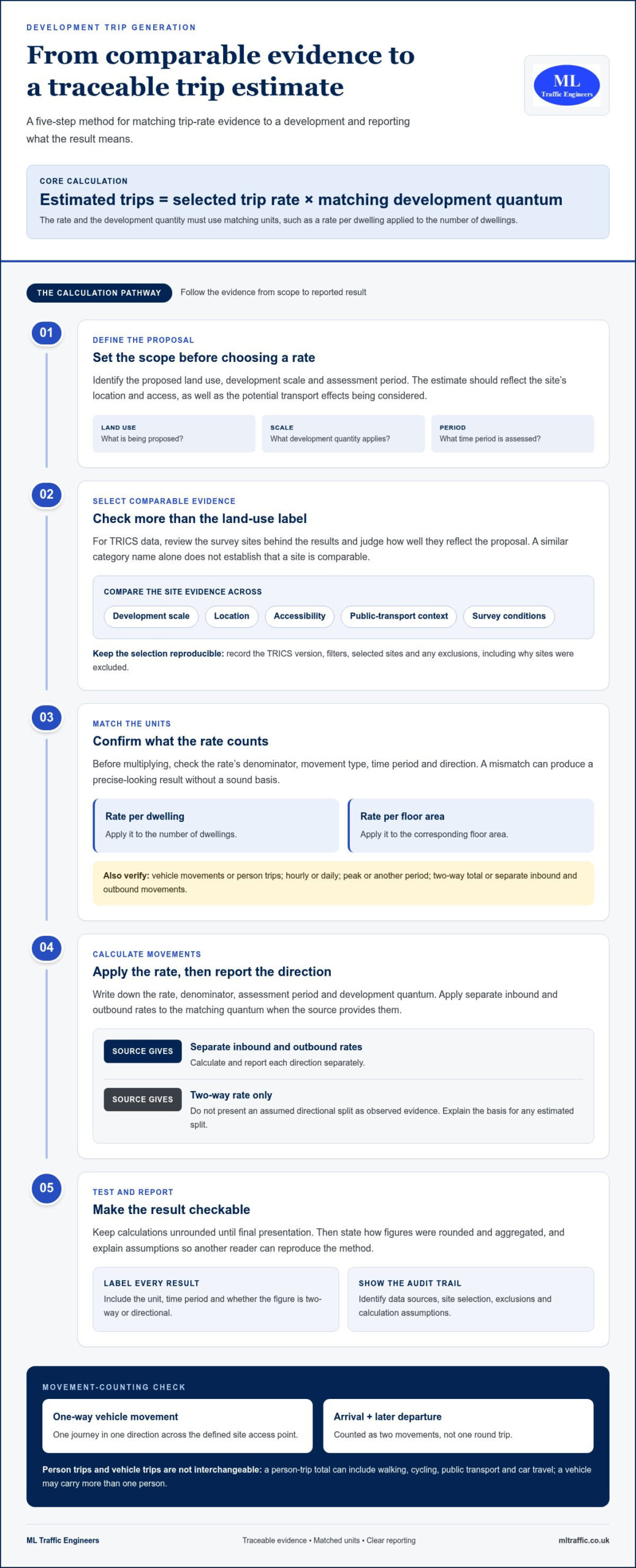
State exactly what the estimate counts. A one-way vehicle movement is one journey in one direction across the defined site access point. An arrival followed later by a departure is two movements, not one round trip. Person trips count people travelling and may include walking, cycling, public transport and car travel. Because a vehicle may carry more than one person, vehicle and person totals are not interchangeable.
Label every result with its unit and period. State whether it is hourly or daily, whether it covers a peak period, and whether it reports two-way movements or separate inbound and outbound movements. Without those details, figures can be misread or compared incorrectly.
When should a development assess trip generation?
Assessment scope should reflect the proposal’s scale, land use and potential transport effects. A smaller scheme with limited implications may need proportionate evidence, while a larger or more complex proposal may require fuller analysis. The local planning or highway authority can guide the appropriate level of evidence for the site and application.
Trip estimates help explain how a proposal relates to access arrangements, travel modes and transport effects. They may form part of a Transport Statement or a more detailed Transport Assessment. For further context, see our Transport Assessment guidance for developers. The next step is to select evidence that matches the development and the movements being assessed.
How to calculate trip generation using comparable evidence
A defensible calculation follows a clear sequence: define the proposed development, identify relevant evidence, apply a rate to the matching development quantum, test the assumptions, then report the method and results. The core relationship is:
Estimated trips = selected trip rate × matching development quantum
The units must match. A rate expressed per dwelling applies to the number of dwellings; a rate per square metre of floor area applies to the corresponding floor area. Before multiplying, check whether the rate represents vehicle movements or person trips, and confirm its time period and direction. A mismatch can produce a precise-looking result without a sound basis.
How do you select and use TRICS trip-rate evidence?
Start by identifying TRICS land-use categories that reflect the proposal, then review the survey sites behind the results. Compare their development scale, location, accessibility, public-transport context and survey conditions with the proposed site. A database result is not automatically comparable just because its land-use label looks similar.
For a reproducible analysis, record the TRICS version, filters, selected sites and any exclusions, including the reasons for excluding them. TRICS 8.26.2 was identified as the latest stable release in November 2025. Check the current database version and survey-selection guidance when preparing an assessment.
How do you calculate arrivals, departures and total movements?
Write down the rate, denominator, assessment period and development quantum before calculating. If the source provides separate inbound and outbound rates, apply each to the matching quantum and report the results separately. If it provides only a two-way rate, don’t present an assumed directional split as observed evidence. Explain the basis for any estimated split.
Keep calculations unrounded until the final presentation, then state how you rounded and aggregated them. Report units clearly, such as movements per hour or movements per day, and avoid implying greater certainty than the survey evidence supports.
- Define: land use, scale and assessment period.
- Select: comparable evidence and document exclusions.
- Calculate: apply the rate to its matching quantum.
- Test and report: explain assumptions, units and rounding.
Trip estimates can form part of the evidence in a proportionate Transport Statement or Transport Assessment. The official government guidance sets out the role of these planning documents. To calculate trip generation for a development, keep the working traceable from source data to reported totals, so the assumptions can be reviewed alongside the wider transport evidence.
Where a proposal needs project-specific analysis, trip-generation evidence can be considered within a Transport Assessment for a planning application.
How should you compare trip-rate data and account for site context?
A trip rate is useful only when its source reflects the proposal closely enough to support comparison. TRICS outputs, observed traffic surveys and local evidence can each inform an assessment, but they measure different things and should not be treated as interchangeable. Check what each source counts, how it was collected and whether its conditions match the site and assessment period.
A nearby development isn’t automatically a good comparator. Its land use, scale, access arrangements, public-transport options or surrounding uses may produce a different travel pattern. Record why you selected or excluded evidence rather than relying on proximity alone.
| Evidence source | Compare | Key limitations to record |
|---|---|---|
| TRICS output | Land-use category, site geography, survey period and rate denominator | Selection filters, chosen sites and differences from the proposed development |
| Observed survey | Site function, access, day type, peak period and movements counted | Survey date, unusual conditions and whether the period represents typical activity |
| Local evidence | Relevance to the proposal, location, land use and measurement units | Source, collection method, coverage and any assumptions used to apply it |
Which factors make a comparable survey site credible?
Check whether the comparator has a similar land-use function, scale, occupancy or operating pattern. Then consider the local context, including access to public transport, nearby homes and services, and how people can reach the site. Review the survey date, season, day type and peak period. If conditions were unusual or the match is imperfect, state the limitation and explain why it matters.
Keep mode share separate from vehicle trip rates. A vehicle rate does not describe all journeys made by walking, cycling or public transport. Don’t apply a mode-share adjustment simply because a site appears accessible. Use project-specific evidence or a clear, justified method.
When should you adjust gross trips to estimate net change?
Where a site has an existing lawful use, first establish whether its trips are supported by evidence and relevant to the same assessment period. Show the proposed development’s gross trips, then any existing-use deduction as a separate step. Explain the evidence and calculation for each. Treat pass-by, diverted and linked trips cautiously, and include an adjustment only when the method and supporting evidence justify it.
These comparisons make how to calculate trip generation for a development transparent and defensible. They also support a proportionate Transport Statement or Transport Assessment, as outlined in official government guidance. For London planning context, see the London transport assessment guide. Project-specific Transport Assessment support can bring evidence and assumptions together in a clear planning submission. See ML Traffic Engineers UK transport planning information.
How do you test assumptions and present a robust calculation?
A calculation is useful only if another reviewer can follow how you reached it. Keep a clear audit trail from the development inputs to the reported trip totals, and state where evidence is limited. This makes it easier to consider the estimate alongside access arrangements, sustainable travel options and the likely effects on the surrounding highway network.
What should a sensitivity check include?
Identify assumptions that could materially influence the result, such as development quantum, occupancy or the selected trip rate. Test a reasonable alternative only when its basis is stated and supportable. For example, compare the chosen rate with another relevant evidence-based rate and explain why it provides a credible alternative. Report how each scenario affects the total and whether it changes the assessment’s conclusions. There is no universal sensitivity threshold to apply.
What should the calculation report show?
Include enough information to reproduce the calculation and understand its limits. A practical checklist is:
- Proposal: land use, scale and development quantum.
- Evidence: source, selected rate and reasons for its use.
- Definitions: calculation unit, movement type and assessment period.
- Working: formula, inputs, directional totals and any gross-to-net steps.
- Qualifications: assumptions, limitations, rounding and matters that may need agreement with the relevant planning or highway authority.
Keep arrivals and departures visible where the evidence supports a directional split. Show gross proposed trips separately from any deduction for an existing use, and explain the basis for each figure. Round consistently, but don’t present a modelled estimate as a precise prediction of future traffic.
Use the results to frame the transport questions that follow. Consider whether access arrangements can accommodate the movements, how walking, cycling and public transport relate to the proposal, and whether further analysis of highway effects is warranted. This makes trip-generation calculations part of a proportionate planning assessment rather than an isolated number.
For related planning context, read the Transport Statement for a planning application. If your project needs its assumptions and evidence brought together for submission, discuss your trip-generation analysis with ML Traffic Engineers.
How trip generation informs a Transport Statement or Transport Assessment
A trip-generation estimate gives a planning submission a starting point for describing the movements a development may produce. Within a Transport Statement or Transport Assessment, it helps explain how the proposal relates to site access, travel by different modes and potential effects on the surrounding transport network. The estimate should support the wider evidence, not stand alone as a prediction of exactly what will happen.
The appropriate level of detail depends on the development’s scale, land use, location and likely transport effects, as well as the planning and highway authority context. A smaller proposal may need a concise, proportionate account; a more complex scheme may call for fuller analysis. Neither report type nor calculation method is automatically necessary for every application. Consider the relevant authority’s requirements and the project’s circumstances.
Trip generation also helps frame practical questions: can the proposed access accommodate expected movements, what proportion may use sustainable modes, and where could further assessment of transport effects be needed? Clear assumptions make these connections easier to review.
When is project-specific transport analysis valuable?
Project-specific analysis is useful when a site’s context differs from standard comparators, key inputs remain uncertain or authority feedback raises questions about the evidence. Traffic surveys can help test assumptions about existing conditions or local movement patterns where appropriate. Select and interpret surveys for the question being assessed, rather than treating them as a substitute for development trip-rate evidence.
This scrutiny strengthens the link between calculating trip generation for a development and the planning decisions the calculation is intended to inform. ML Traffic Engineers prepares Transport Statements and Transport Assessments for planning applications, using traffic surveys and technical analysis where relevant. Explore development transport planning projects for related project context.
What are the next steps for a developer?
Bring the core project information together before settling the assessment scope. This gives the trip-generation analysis a clear basis and helps identify gaps early.
- Site: location, proposed land use and development quantum.
- Access: existing and proposed access arrangements.
- Evidence: available surveys, transport data and assumptions already used.
- Planning context: relevant discussions or feedback from the local planning or highway authority.
With these details in hand, the estimate can be considered alongside the wider transport evidence and tailored to the proposal. To discuss project-specific analysis for your development, discuss transport planning support for your development with ML Traffic Engineers.
Build a trip estimate your planning submission can stand behind
A credible trip-generation calculation is more than a rate multiplied by a development size. It depends on comparable evidence, matched units and assessment periods, and assumptions that are clearly stated and tested. Keep the result reproducible, distinguish vehicle movements from person trips, and present uncertainty honestly.
Use the estimate as part of the wider transport case. Its role is to explain how the development relates to site access, travel choices and potential transport effects, with the level of assessment proportionate to the proposal and its planning context. Understanding how to calculate trip generation for a development gives you a firmer basis for that evidence, while project-specific analysis can help address site conditions or inputs that need closer review.
ML Traffic Engineers prepares Transport Statements and Transport Assessments for planning applications. Traffic surveys and technical analysis can support evidence tailored to the project. Discuss transport planning support for your development and take the next step with a clearer evidence base.
With transparent assumptions and relevant transport evidence, you can move your proposal forward with greater confidence.
Frequently Asked Questions
How do you calculate trip generation for a development?
Multiply a suitable trip rate by the matching development quantum, then check that the rate’s units, denominator and assessment period fit the proposal. For example, apply a rate per dwelling to the number of dwellings, not the floor area. Record the evidence source and explain any assumptions. Where the data supports it, report arrivals and departures separately, and test how reasonable changes to key inputs affect the estimate.
What is a trip rate in development planning?
A trip rate expresses the number of movements associated with a defined land use and unit of development over a stated period. It might be reported per dwelling, per floor area or another relevant measure. Check whether it refers to vehicle movements or person trips, and whether it covers an hour, a day or a peak period. The rate’s definition determines how it can be used in a calculation.
Can I use TRICS to calculate trips for any development?
TRICS can provide trip-rate evidence when its recorded land-use and survey data are relevant to the proposal, but it won’t automatically provide a suitable comparator for every development. Assess selected sites for function, scale, location, access, travel context and survey period. Document the database version, filters and exclusions, and explain any limitations. If available TRICS evidence is a poor fit, use other justified evidence rather than forcing an unsuitable comparison.
How do I calculate vehicle trips from person trips?
You can’t reliably convert person trips into vehicle trips without evidence about travel mode and, for car travel, vehicle occupancy. First establish how many person trips are made by each mode, then apply a supported mode-share assumption and occupancy factor to estimate vehicle movements. Keep those inputs visible and relevant to the project. Don’t treat person trips and vehicle trips as equivalent or assume every person travelling by car creates a separate vehicle.
Should existing site trips be deducted from development trip generation?
Deduct existing trips only when the site has an existing lawful use and its trip generation is supported by relevant evidence. Check that the existing-use figures relate to a comparable time period and movement type. Present the proposed development’s gross trips first, then show the existing-use deduction separately to calculate net change. Explain the evidence and assumptions behind both stages so reviewers can follow how the net estimate was derived.
What is the difference between gross and net trip generation?
Gross trip generation is the estimated movement total for the proposed development before deducting trips associated with an existing use. Net trip generation is the resulting change after any justified existing-use trips are subtracted. For example, a redevelopment may have fewer net trips than gross trips if a previous lawful use generated movements. Report both figures and show the calculation rather than presenting a net total without its supporting steps.
Does every development need a Transport Assessment to calculate trip generation?
No. The appropriate transport evidence depends on the proposal’s scale, land use, location and likely transport effects, as well as the planning and highway authority context. A proportionate Transport Statement may suit some schemes; others may need a fuller Transport Assessment. Requirements can vary by project and authority. This applies to developments across Greater London, Manchester, Birmingham, the West Midlands, Liverpool and southern counties, including Surrey, East Sussex, West Sussex, Hampshire, Berkshire and Buckinghamshire.

Disclaimer
The content on mltraffic.co.uk, including all technical articles, guides, and resources, is provided for general informational and educational purposes only. It is not intended to constitute professional advice in traffic engineering, transportation planning, development approvals, or any other technical or legal field.
While ML Traffic Engineers makes every reasonable effort to ensure the accuracy, completeness, and timeliness of the information published, we do not provide any warranties or representations (express or implied) regarding its reliability, suitability, or availability for any particular purpose. Any reliance you place on the content is strictly at your own risk.
In no event shall ML Traffic Engineers, its directors, employees, authors, or affiliates be liable for any direct, indirect, incidental, special, consequential, or punitive damages (including, without limitation, loss of profits, data, or business opportunities) arising out of or in connection with the use of, or inability to use, any information provided on this website.
The articles and guides on this site are not a substitute for engaging a qualified, professional traffic engineer to assess your specific project requirements. For tailored advice, compliance assessments, or traffic engineering services, please contact a competent professional.
This disclaimer may be updated from time to time without notice. By accessing or using this website, you agree to be bound by the most current version of this disclaimer.