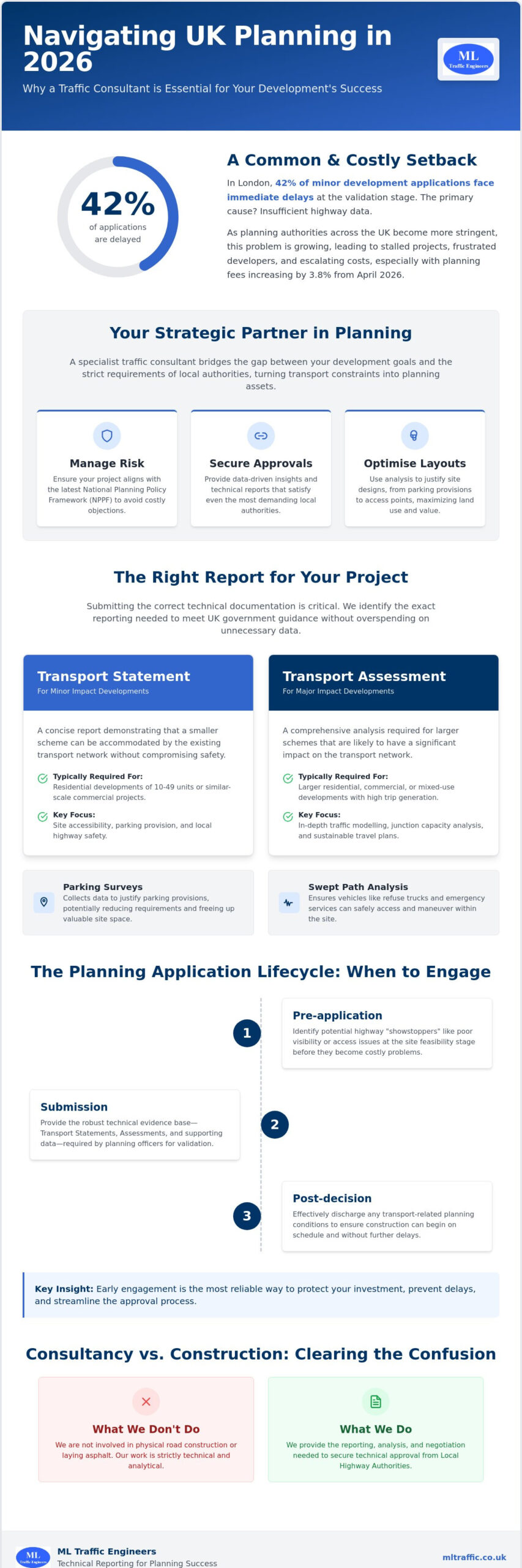
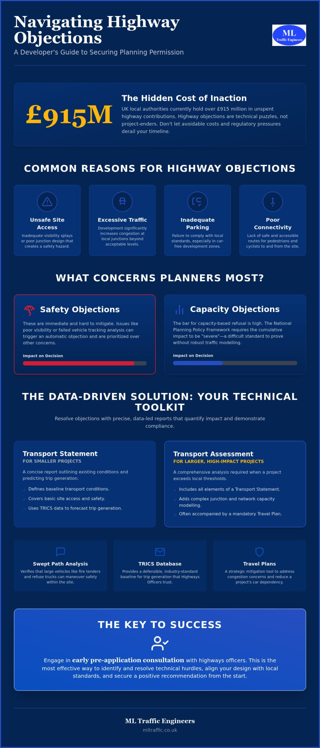
A Highways Authority objection shouldn’t be the end of your development project. Many developers view planning permission traffic issues as insurmountable hurdles; however, they’re actually technical puzzles that you can solve with precise data. It’s frustrating to face unexpected costs for off-site works, especially when local authorities are already holding over £915 million in unspent highway contributions as of 2026. You need a reliable way to move past these regulatory pressures and keep your project timeline on track.
This guide provides a clear strategy to identify, mitigate, and resolve highway objections to secure your approvals. You’ll learn how to produce technical reports that satisfy the Local Planning Authority while reducing unnecessary mitigation expenses. We’ll examine the updated 2026 Transport Analysis Guidance and show you how specialized tools like Swept Path Analysis and Transport Statements provide the technical authority required to clear your path to planning permission. Outside of the planning sphere, other industries also rely on precision technology to manage complex vehicle data; for example, you can learn more about Carcode Mileage Blockers and their specialized applications.
Key Takeaways
- Identify common highway objections, such as inadequate visibility splays, before they lead to formal application delays.
- Differentiate between Transport Statements and Assessments to ensure you submit the correct documentation for planning permission traffic issues.
- Utilize Swept Path Analysis to verify that fire tenders and refuse vehicles can maneuver safely within your proposed development.
- Deploy strategic mitigation tools like Travel Plans to address local congestion concerns and reduce a project’s car dependency.
- Engage in early pre-application consultation to resolve technical hurdles and avoid the high costs of planning appeals.
Common Highway and Traffic Issues in Planning Permission
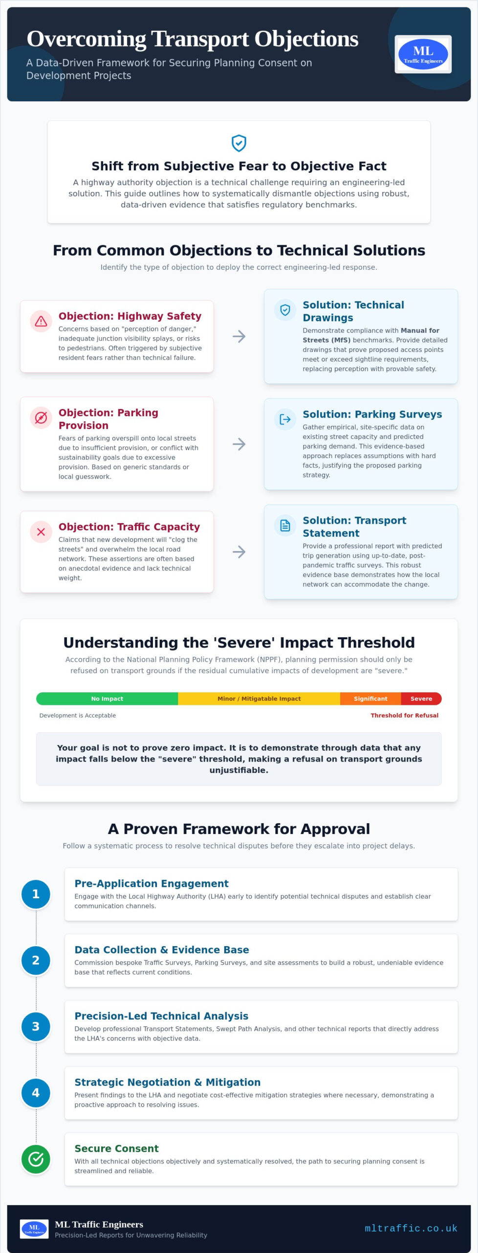
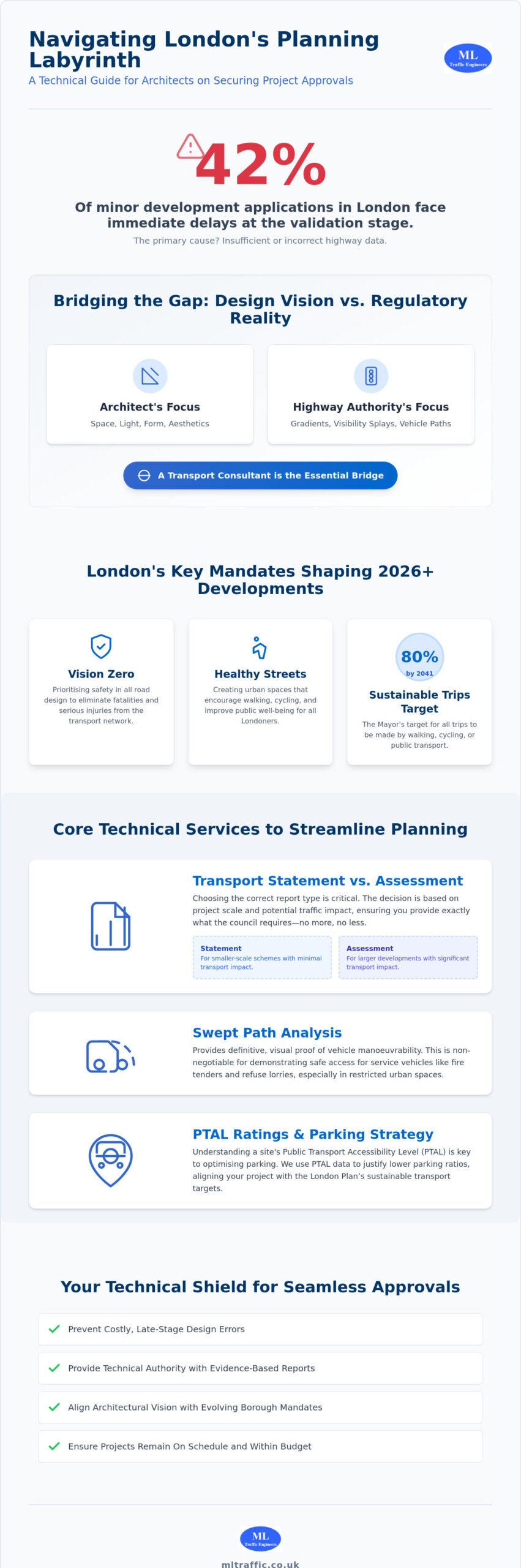
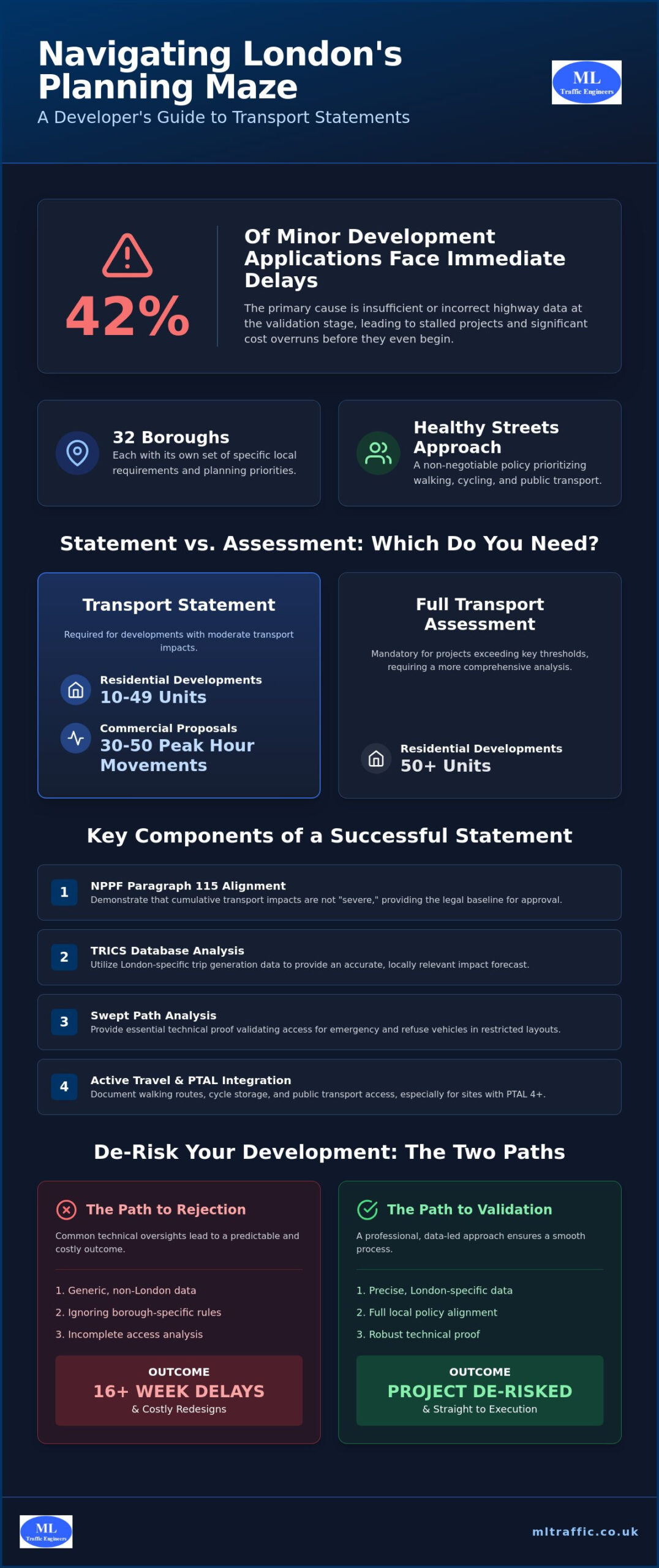
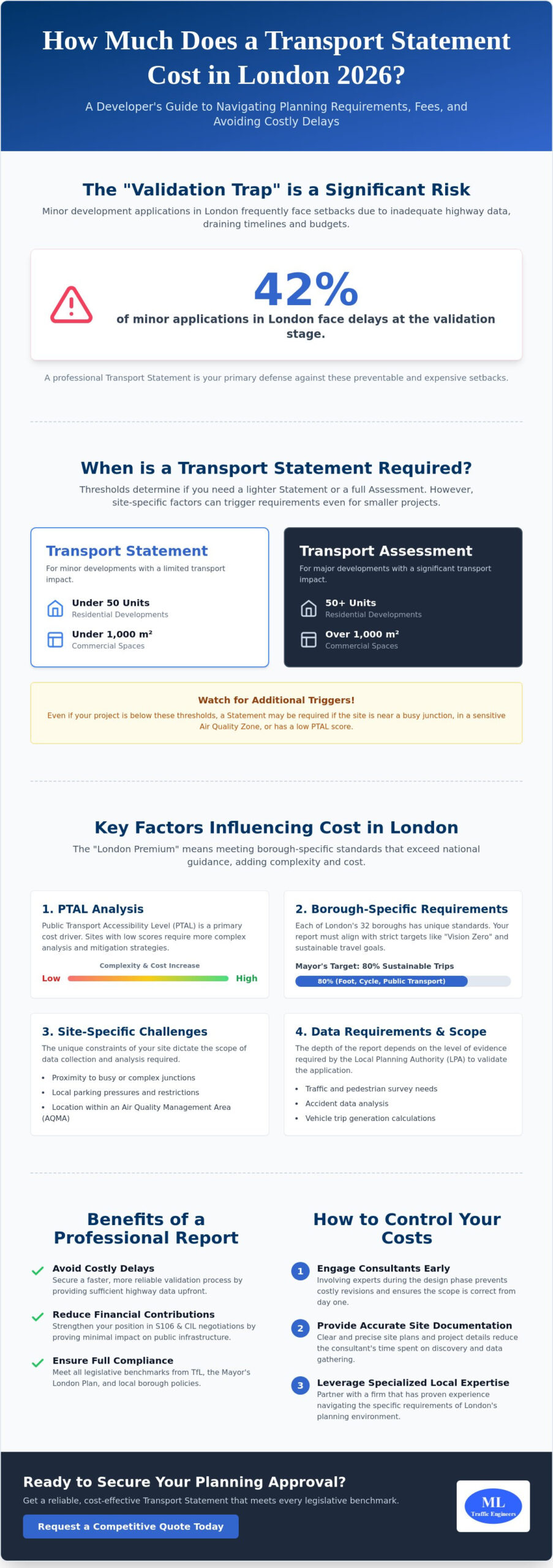
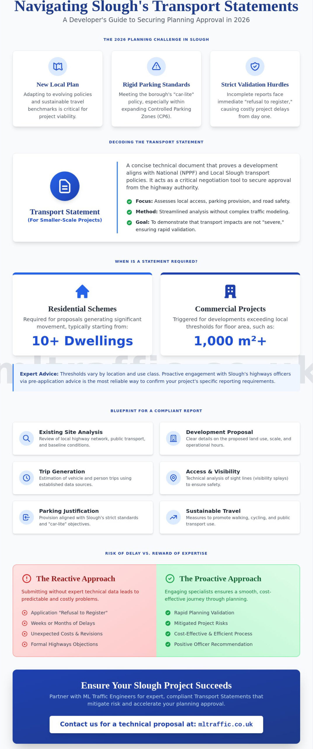
Securing project approval requires a proactive approach to planning permission traffic issues. Most refusals stem from four core technical failures: unsafe site access, excessive traffic volume, inadequate parking, and poor pedestrian connectivity. If your site entrance lacks the required visibility splays, it creates a safety hazard that planners cannot ignore. Similarly, if a development significantly increases congestion at a local junction, the impact may be deemed unacceptable. In urban centers, the 2026 London Plan now mandates car-free developments in areas with high public transport accessibility, making parking provision a critical compliance hurdle.
To better understand how these objections manifest during the planning process, watch this helpful video:
The Role of the Local Highway Authority (LHA)
The LHA serves as a statutory consultee, providing expert technical advice to the planning officer. While they don’t issue the final decision, their recommendation for refusal is often a project-killer. Local authorities are currently holding approximately £915 million in unspent Section 106 funds for highways, yet they remain under pressure to ensure new developments don’t degrade the existing network. Early engagement with highways officers is the most effective way to prevent 2026 application delays. By addressing planning permission traffic issues during the pre-application stage, you can align your design with local standards and secure a positive recommendation from the start.
Safety vs. Capacity: What Concerns Planners Most?
The National Planning Policy Framework (NPPF) sets a high bar for capacity-based refusals, stating that development should only be prevented if the residual cumulative impacts on the road network are “severe.” Proving a “severe” impact is difficult and requires robust traffic modelling. In contrast, safety objections are immediate and harder to mitigate. A lack of adequate visibility or a failure to demonstrate safe vehicle tracking through Swept Path Analysis will trigger an automatic objection. These safety concerns are often documented within a wider Environmental Impact Assessment (EIA) for large-scale projects. While resident objections are often based on anecdotal fears of congestion, the LPA prioritizes technical data and safety standards over public opinion. Precision in your technical submission is the only way to neutralize these concerns.
The Technical Reports Required to Resolve Traffic Objections
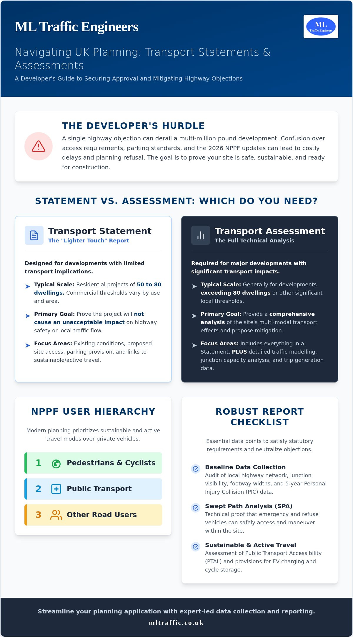
Resolving planning permission traffic issues requires a data-led approach that prioritizes technical precision over general assumptions. Developers must provide technical reports that quantify the impact of their proposal and demonstrate safety compliance. For smaller projects, a Transport Statement is the standard requirement. This document outlines existing transport conditions and predicts how many trips the new site will generate. To ensure these predictions are robust, engineers use the TRICS database. This industry-standard tool compares your site to similar developments across the UK, providing a defensible baseline for trip generation that Highways Officers trust.
Transport Statement vs. Transport Assessment
The choice between a statement and an assessment depends on the scale of the development and the local context. Local authorities set specific thresholds for these reports based on official government guidance. While a statement covers basic site access and safety, a Transport Assessment is a comprehensive report required for larger, high-impact projects. It often includes complex junction modelling and a detailed analysis of the wider network capacity. If your project exceeds the local threshold, a simple statement will not satisfy the Highways Authority. In these cases, you must also submit Travel Plans to demonstrate how you will encourage sustainable transport use and reduce the overall carbon footprint of the site.
The Importance of Accurate Traffic Data
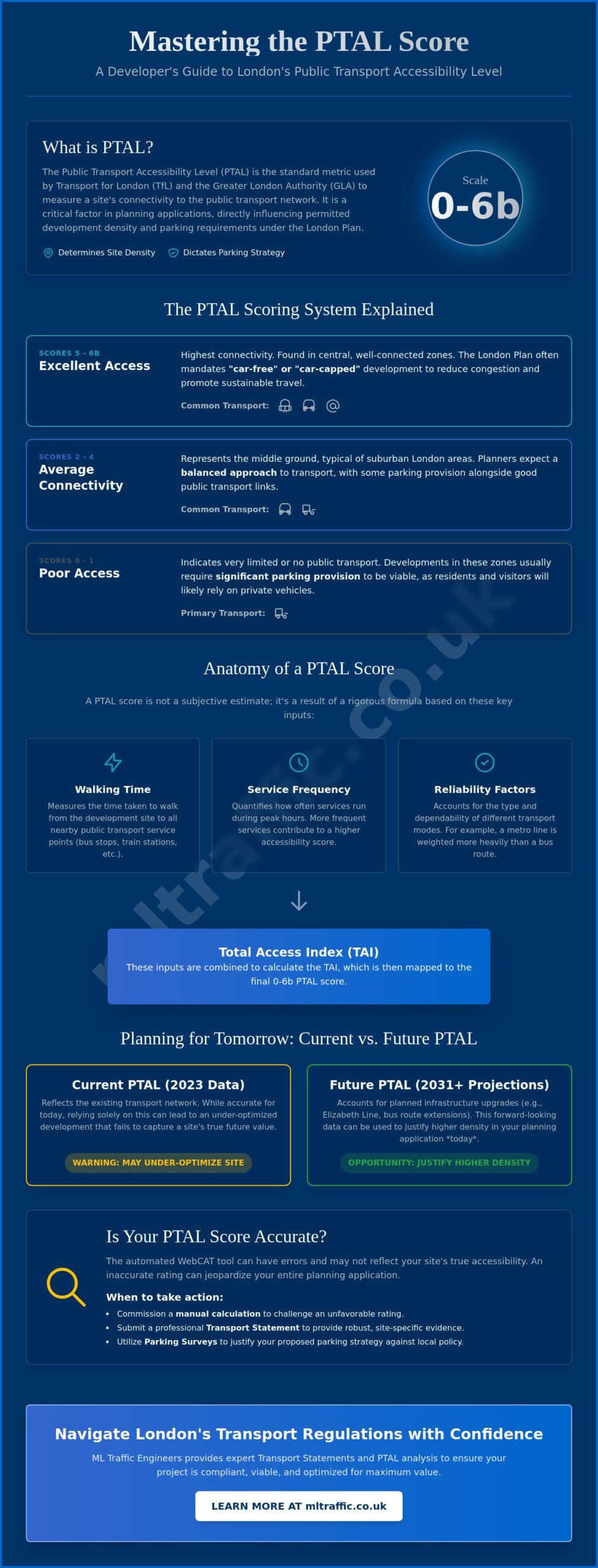
Technical authority relies entirely on the quality of the underlying data. Automatic Traffic Counts (ATC) provide 24-hour volume and speed data over several days, offering a more reliable picture than manual snapshots. When parking is a major concern, we conduct Parking Surveys using the Lambeth Methodology. This standardized approach measures parking stress within a 200-meter radius of the site, providing the empirical evidence needed to prove that a development won’t overwhelm local street capacity. Utilizing high-resolution 2026 traffic data ensures your application reflects current road conditions, effectively neutralizing objections based on outdated or anecdotal traffic figures.
Precision in these reports reduces the risk of costly delays or requests for further information. If you are unsure which technical report your site requires, reviewing our comprehensive service list can help you identify the necessary documentation for a successful submission. Providing the right data early in the process establishes your project as a well-planned, safety-conscious development.
Overcoming Specific Hurdles: Access, Visibility, and Maneuverability
Physical constraints often create the most difficult planning permission traffic issues for developers. While a site might be perfectly located for residential use, it’s the geometry of the access point that determines its viability. You must prove that the site can accommodate the necessary vehicle movements without compromising the safety of the existing highway. This involves balancing high-density development goals with the rigid spatial requirements for parking and emergency vehicle access. Failing to address these spatial needs early often leads to costly redesigns or application refusals.
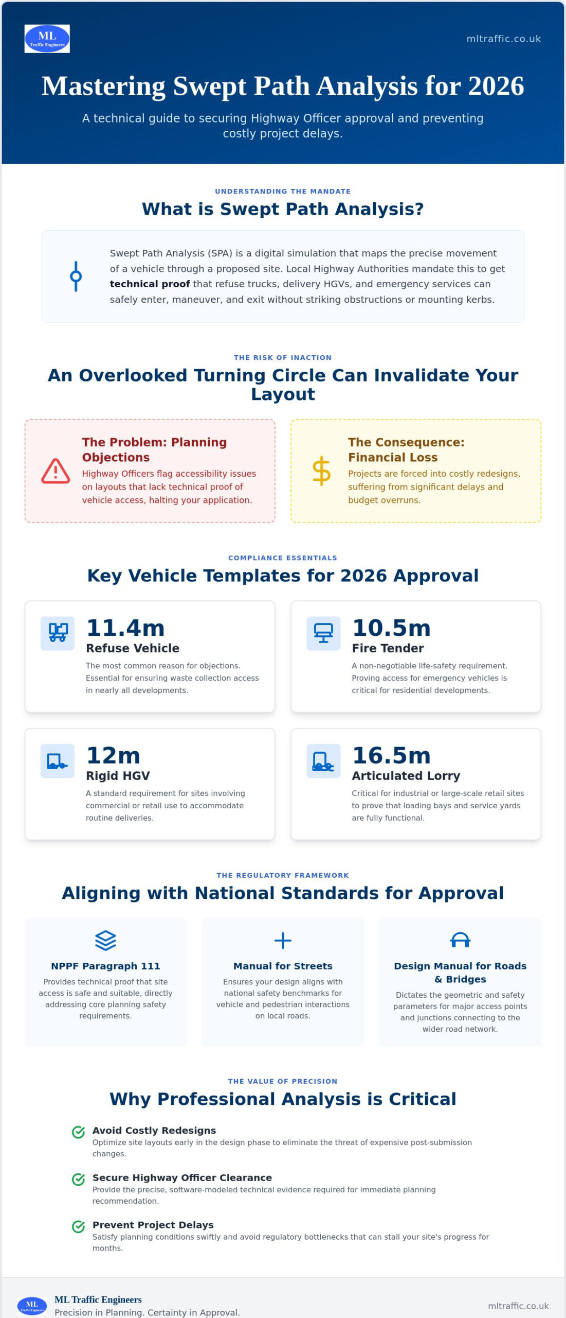
Applying Swept Path Analysis (SPA)
Planners require definitive proof that large vehicles can maneuver within your site. We use Swept Path Analysis to model these movements digitally. By utilizing AutoCAD and AutoTurn software, we simulate the exact path of fire tenders, refuse vehicles, and HGVs. This is particularly vital for tight urban developments or sites with narrow access roads where there’s zero margin for error. A successful SPA demonstration prevents the Highways Authority from objecting on the grounds of poor internal maneuverability. It allows you to maximize the developable area while ensuring the site remains fully functional for essential services.
Visibility Splays and Highway Safety
Safe site access depends on achieving correct visibility splays. These are the triangular areas that must be kept clear of obstructions so that drivers can see approaching traffic. We calculate the “X” distance (the distance back from the junction) and “Y” distance (the distance along the main road) based on local road speeds and the standards set out in Manual for Streets. With the updated “Manual for Streets 3” expected by the end of 2026, staying current with these evolving design standards is crucial for project success.
Achieving these splays is often difficult on curved roads or near existing junctions. In these scenarios, we provide Expert Traffic Engineering Guidance to identify alternative mitigation options. This might include traffic calming measures or speed surveys to justify shorter splay lengths based on actual vehicle speeds rather than the speed limit. Resolving these hurdles early also prevents “ransom strip” issues where you might otherwise need third-party land to achieve the required visibility. Precision in these calculations ensures your site entrance meets safety benchmarks without requiring excessive land take.
Strategic Mitigation: How to Turn a Refusal into an Approval
Proactive mitigation transforms planning permission traffic issues from roadblocks into manageable project components. When a Local Planning Authority (LPA) identifies a potential “severe impact” on the network, you must propose tangible solutions to offset that pressure. This often involves a combination of behavioral changes through Travel Plans and physical infrastructure upgrades via statutory agreements. By offering these solutions upfront, you demonstrate a commitment to highway safety and network efficiency. This professional approach makes it significantly harder for planners to justify a refusal on traffic grounds.
Developing an Effective Travel Plan
A well-crafted Travel Plan is a powerful tool for reducing a site’s car dependency. In 2026, the shift toward “Active Travel” means planners prioritize developments that incentivize walking, cycling, and public transport use. We design these strategy documents to include practical measures like car-sharing schemes or cycle-to-work subsidies for future residents. Successfully implementing these measures can often lower the required parking ratio, which allows for higher site density. The LPA expects these plans to be living documents with clear monitoring and enforcement mechanisms to ensure long-term carbon reduction targets are met.
Statutory Agreements: S278 and S38 Explained
Physical road modifications require formal legal frameworks. A Section 278 (S278) agreement allows you to make permanent alterations to the existing public highway, such as creating a new junction or installing a pedestrian crossing. In contrast, a Section 38 (S38) agreement deals with the adoption of new roads built within the development itself. Managing the technical approval process for these works requires constant coordination with the Highways Authority to meet their strict design standards. You’ll need to account for technical audit fees, inspection costs, and the provision of a bond in your 2026 project budget. These agreements ensure that all works meet industry benchmarks for public and worker safety, and organizations like Acquired Awareness Traffic Management help set the standard for operational safety in traffic control.
Financial contributions through Section 106 (S106) agreements also play a vital role. While local authorities currently hold £915 million in unspent highways funds, targeted contributions for public transport links can often resolve capacity concerns at local junctions. Planners don’t accept vague promises; they require binding commitments to infrastructure improvements. If your project faces a potential refusal due to highway capacity, contact our expert engineers to develop a robust mitigation strategy that secures your planning approval.
Securing Permission with Expert Traffic Engineering
A proactive technical strategy is the most effective way to resolve planning permission traffic issues before they escalate into costly legal battles. While some developers wait for a refusal to hire an expert witness, this approach is financially inefficient. An expensive planning appeal often takes months to resolve and offers no guarantee of success. In contrast, submitting a robust Transport Statement or Assessment at the start of the process establishes technical authority and builds trust with the Local Planning Authority. We focus on getting the application right the first time by providing defensible data that addresses the Highways Authority’s concerns directly.
Effective project management requires a seamless relationship between architects, planners, and highways officers. We act as the vital technical partner in this triangle. Architects often prioritize site density and aesthetics, which can inadvertently lead to highway safety conflicts. We review these designs through a safety-conscious lens, ensuring that access points and internal layouts meet all legislative requirements. By seeking pre-application advice and involving traffic consultants early, you can identify potential hurdles while the site layout is still flexible. This collaborative approach reduces regulatory pressure and ensures your project remains viable from inception to completion.
The ML Traffic Engineers Approach
Founded in 2014, ML Traffic Engineers specializes in navigating the intricate landscape of UK planning policy. We provide tailored reporting that speaks the language of local highways officers, addressing specific borough concerns with precision. Our team understands that time is a critical factor in development; therefore, we maintain a constant readiness to deliver rapid data collection and technical analysis. Whether it’s a complex urban site or a rural residential scheme, our proven track record in securing approvals stems from an unwavering commitment to industry benchmarks and professional integrity. We don’t just provide reports; we provide the technical solutions required to move your project forward.
Next Steps for Your Application
The earliest stages of the design phase offer the greatest opportunity to mitigate risk. We recommend a professional feasibility review of your site layout to catch potential planning permission traffic issues before they’re submitted for formal consultation. Commissioning a Transport Assessment or Statement early allows our engineers to integrate safety and maneuverability requirements into your master plan. This prevents the need for expensive redesigns later in the process. Contact ML Traffic Engineers today to discuss your project requirements and secure a clear path to planning approval for your 2026 development.
Streamline Your 2026 Planning Approvals
Navigating the complexities of 2026 highway regulations requires more than just compliance; it demands a strategic, data-led approach. By addressing visibility splays and maneuverability through precise Swept Path Analysis and providing robust Transport Statements early, you eliminate the ambiguity that often leads to refusal. These proactive steps ensure that your project meets safety standards while maximizing developable space on even the most constrained urban sites—an engineering feat that reflects the same attention to detail found in the narrow gauge model kits from Narrow Minded Railworks.
Successfully managing planning permission traffic issues is about translating technical requirements into a clear path for approval. We’ve been specialist consultants in UK transport planning since 2014, providing comprehensive support from initial pre-application advice to final S278 agreements. Our expertise ensures that your technical reports satisfy the Local Planning Authority without incurring unnecessary mitigation costs. Contact ML Traffic Engineers today for a bespoke quote on your Transport Statement or Assessment. Let us handle the regulatory pressures so you can focus on delivering your development. Your project’s success is within reach when backed by technical precision and expert engineering.
Frequently Asked Questions
What are the most common traffic issues that lead to planning refusal?
Inadequate visibility splays and “severe” impacts on local junction capacity are the primary reasons for refusal. Planners also frequently cite a lack of safe pedestrian connectivity or insufficient parking provision that exceeds local standards. These planning permission traffic issues often stem from a failure to provide technical data that justifies the proposed development’s impact on the existing road network.
Can I get planning permission if my site has poor visibility?
You can secure planning permission with restricted visibility by implementing physical mitigation or justifying shorter splay lengths with empirical speed data. If a speed survey proves that actual vehicle speeds are lower than the posted limit, the required “Y” distance can often be reduced. Other solutions include relocating the site access point or installing traffic calming measures to ensure safe exit and entry for all users. While developers focus on the physical infrastructure, individual driver proficiency is also essential for safe roads; for those looking to schedule a driving exam in the Canadian province, you can learn more about the booking process.
How much does a Transport Statement cost for a small development?
The cost of a Transport Statement varies based on the site’s location, the complexity of the access point, and the specific requirements of the local authority. Every project has unique technical hurdles that influence the amount of data collection and engineering analysis required. We recommend requesting a bespoke quote to ensure the reporting matches the exact scale and risk profile of your development without paying for unnecessary modelling.
What is the difference between a Transport Statement and a Transport Assessment?
The primary difference lies in the scale of the development and the depth of the required network analysis. Transport Statements are for smaller projects with limited traffic impact, focusing mainly on site access and local safety. Transport Assessments are comprehensive reports for larger developments that require detailed junction modelling and a multi-modal evaluation of the wider transport network’s capacity and environmental impact.
How does Swept Path Analysis help with fire brigade access requirements?
Swept Path Analysis provides digital proof that a fire tender can enter, turn, and exit your site without striking curbs or parked cars. Building Regulations Part B requires specific access for emergency vehicles, and planners use these simulations to verify compliance. By modelling the exact dimensions of a standard fire appliance, we ensure your site layout is safe and functional for emergency services from the earliest design stage. While ensuring road access for these vehicles is vital, you can also explore Stage 1 Performance Remap to optimize the engine performance and fuel efficiency of your own vehicle fleet.
What happens if the Highways Authority objects to my planning application?
A Highways Authority objection is a technical recommendation for refusal, but it’s not a final decision by the planning officer. You should immediately review the technical grounds for the objection and provide updated data or mitigation strategies to address their concerns. Engaging in a professional technical dialogue often leads to a compromise or a revised design that satisfies safety and capacity requirements while avoiding an appeal.
Do I need a Travel Plan for a residential development of 10 units?
Requirements for Travel Plans vary between local authorities, but they’re increasingly common for developments of 10 units or more in urban areas. In 2026, many planners demand these documents to prove how you’ll reduce car dependency and support active travel. Even for smaller sites, a proactive Travel Plan can help resolve planning permission traffic issues by justifying a lower parking ratio and demonstrating environmental commitment.
What is a Section 278 agreement and why do I need one?
A Section 278 agreement is a legal contract between a developer and the Highway Authority for permanent alterations to the public road. You need one whenever your project requires a new junction, a modified pavement, or improved street lighting on land owned by the council. This agreement ensures that the works meet strict safety standards and are completed at the developer’s expense under the supervision of the local authority.

Disclaimer
The content on mltraffic.co.uk, including all technical articles, guides, and resources, is provided for general informational and educational purposes only. It is not intended to constitute professional advice in traffic engineering, transportation planning, development approvals, or any other technical or legal field.
While ML Traffic Engineers makes every reasonable effort to ensure the accuracy, completeness, and timeliness of the information published, we do not provide any warranties or representations (express or implied) regarding its reliability, suitability, or availability for any particular purpose. Any reliance you place on the content is strictly at your own risk.
In no event shall ML Traffic Engineers, its directors, employees, authors, or affiliates be liable for any direct, indirect, incidental, special, consequential, or punitive damages (including, without limitation, loss of profits, data, or business opportunities) arising out of or in connection with the use of, or inability to use, any information provided on this website.
The articles and guides on this site are not a substitute for engaging a qualified, professional traffic engineer to assess your specific project requirements. For tailored advice, compliance assessments, or traffic engineering services, please contact a competent professional.
This disclaimer may be updated from time to time without notice. By accessing or using this website, you agree to be bound by the most current version of this disclaimer.