Tag: traffic impact

  • Transport Assessment Scope for Redbridge Housing Developments

    Transport Assessment Scope for Redbridge Housing Developments

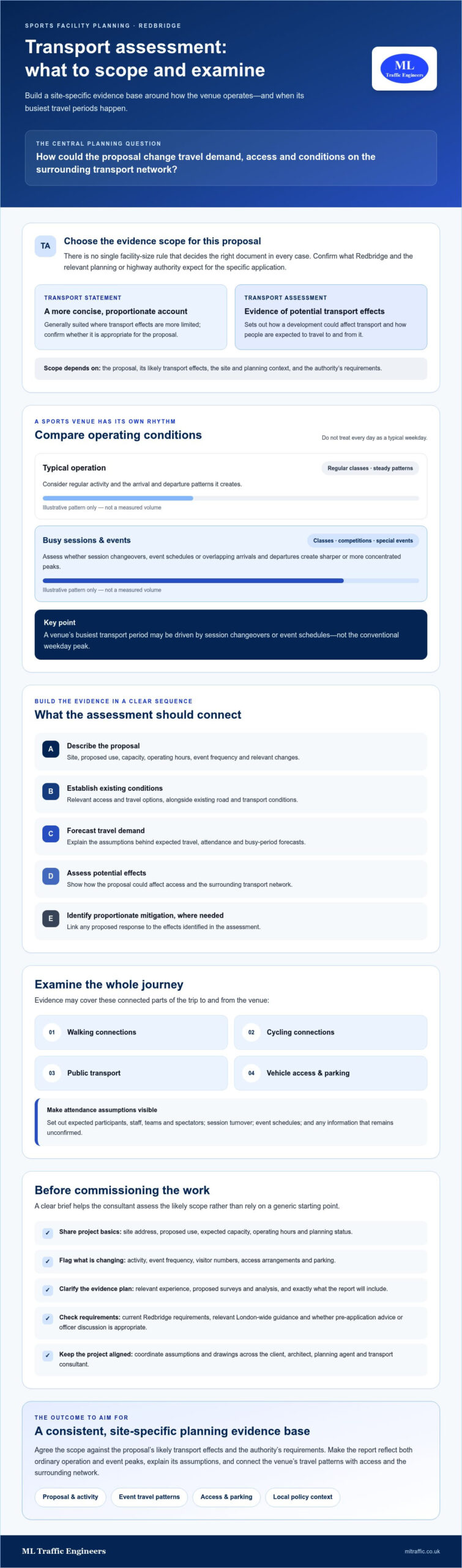
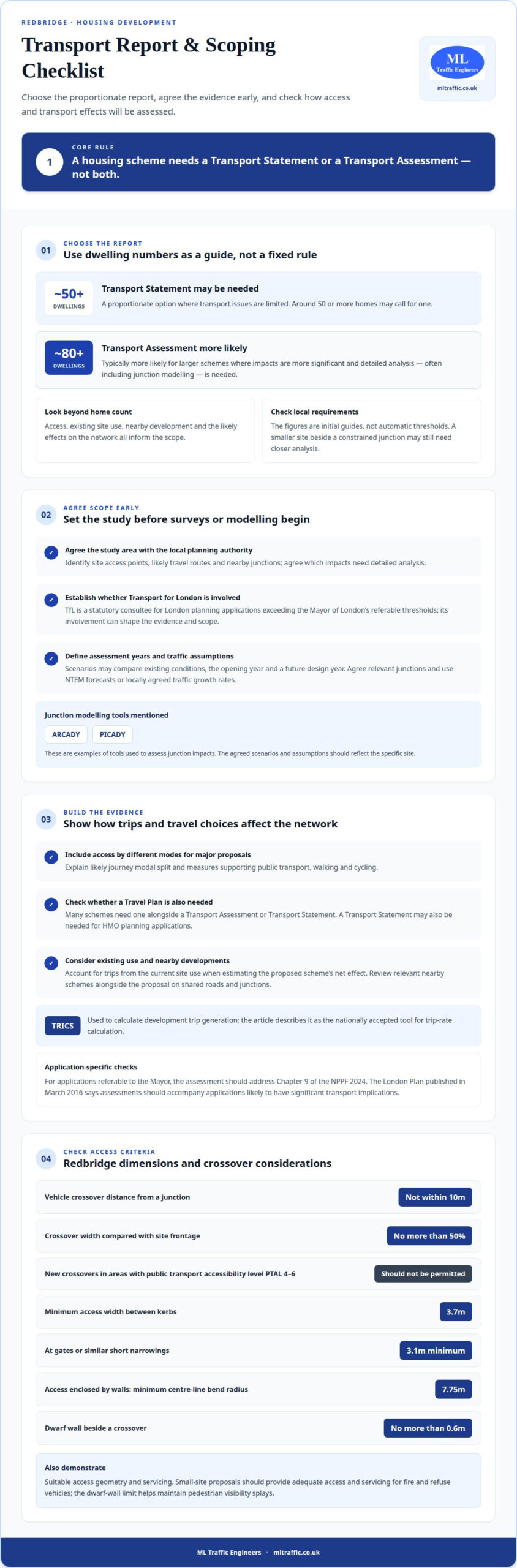
    The number of homes matters, but it isn’t the only factor. A transport assessment for a housing development in Redbridge may be needed where transport impacts are significant and detailed analysis is required. Around 50 or more homes may call for a Transport Statement, while developments of typically 80 or more are more likely to need a Transport Assessment; the local authority’s requirements and the proposal’s likely effects also matter.

    Before committing time to a planning application, establish which report is appropriate. A Transport Statement covers proposals with limited transport issues, while a Transport Assessment examines more substantial impacts, often including junction modelling. A development needs one or the other, not both.

    This guide explains how to identify the right report, what scoping with the local planning authority and Transport for London involves, and how a review considers traffic, access and highway safety. It also covers what affects preparation and what information helps tailor a report to the development and its surroundings.

    Key Takeaways

    • Scope the transport work early so the study reflects the development, its likely impacts and the planning authorities involved.
    • Choose the report based on the scale and nature of transport effects, not dwelling numbers alone.
    • Use a review of personal injury accident records to identify existing highway safety issues near the site.
    • Account for Redbridge-specific planning considerations, including the transport statement requirement for HMO applications.
    • Bring together evidence on access, traffic, parking and sustainable travel to show how the proposal may affect the local network.

    Scoping with the local planning authority and Transport for London

    Agree the assessment scope early, before surveys or modelling begin. Redbridge’s access conditions and Transport for London’s role can affect the evidence a housing proposal needs.

    Planning Authority Scoping

    Scoping defines the study area, evidence, assessment years and methods for the application. Identify site access points, likely travel routes and nearby junctions, then agree with the local planning authority which impacts need detailed analysis. Transport for London is a statutory consultee for London planning applications exceeding the Mayor of London’s referable thresholds, so its involvement can shape the scope.

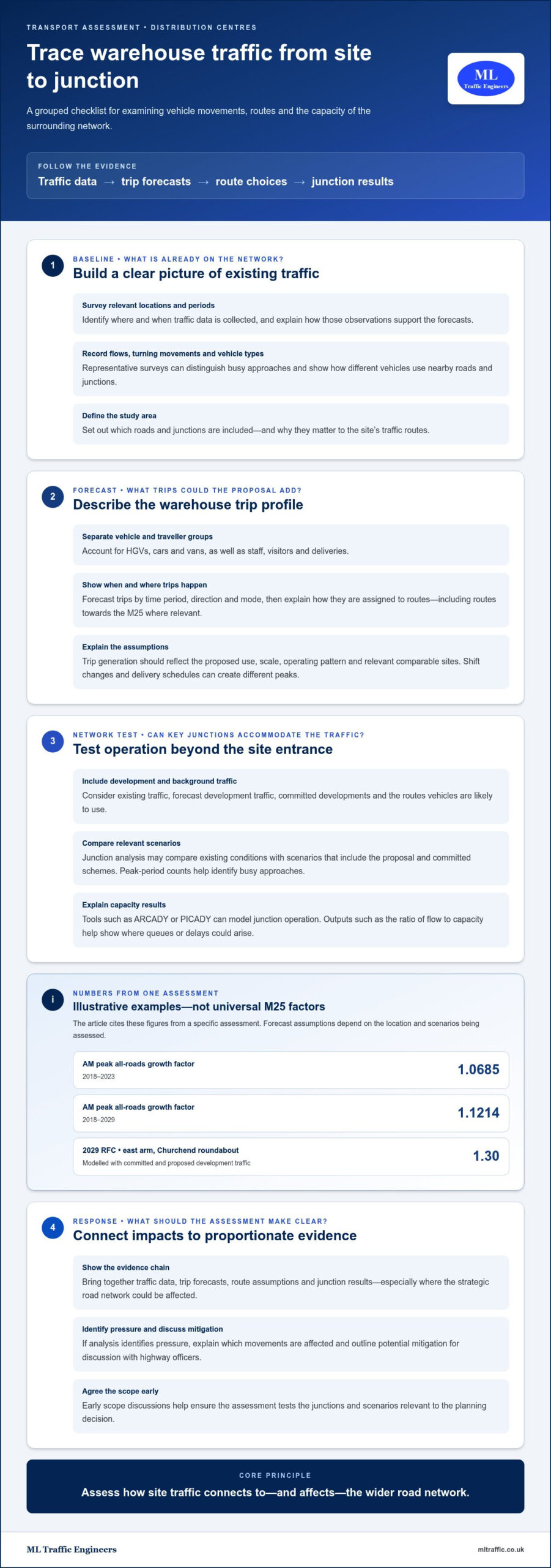
    ARCADY and PICADY are examples of tools used to assess junction impacts. Assessments may compare existing conditions, the opening year and a future design year, using NTEM forecasts or locally agreed traffic growth rates. Establish the relevant junctions, scenarios and growth assumptions during scoping, rather than treating them as a standard package for every Redbridge site.

    Assessment and Travel Plan Guidance

    Redbridge’s planning approach considers the transport effects of the proposed homes and the evidence needed to assess them. The London Plan published in March 2016 says transport assessments should accompany applications likely to have significant transport implications. For major proposals, the assessment should explain access by different modes, likely journey modal split and measures supporting public transport, walking and cycling.

    Many schemes need a Travel Plan alongside a Transport Assessment or Transport Statement. A transport statement may be needed for HMO planning applications. Scoping should therefore identify the application type and whether a separate Travel Plan is needed. For applications referable to the Mayor, transport assessments should address Chapter 9 of the NPPF 2024.

    Highway and Transport Mitigation

    Mitigation should respond to the transport effects identified in the assessment. Redbridge access guidance states that proposed vehicle crossovers should not be within 10m of junctions, and their width should not exceed 50% of the site frontage. New crossovers should not be permitted in areas with a public transport accessibility level of PTAL 4-6. These criteria can influence the layout before submission.

    Access design also needs to demonstrate suitable geometry and servicing. Redbridge specifies a minimum width of 3.7m between kerbs, or 3.1m at gates or similar short narrowings; access enclosed by walls needs a minimum centre-line bend radius of 7.75m. Small-site proposals should provide adequate access and servicing for fire and refuse vehicles. A dwarf wall beside a crossover should not exceed 0.6m, helping maintain pedestrian visibility splays.

    Requests for changes commonly arise when traffic assumptions are unclear, junction impacts have not been tested, access arrangements conflict with the relevant criteria, or mitigation does not address identified effects. Redbridge’s assessment may also need to explain how walking, cycling and public transport access will improve. Clear scope, transparent assumptions and proportionate mitigation help address these issues directly.

    When a housing development needs a Transport Assessment or Transport Statement

    The right report depends on the proposal’s likely transport effects, not dwelling numbers alone. In Redbridge, the scale, access, existing site use and nearby development all inform the assessment scope.

    Assessment or Statement Requirements

    A Transport Statement is proportionate where a proposal has limited transport issues. A Transport Assessment is appropriate where impacts are more significant and detailed analysis, often including junction modelling, is needed. A housing scheme needs one report or the other, not both.

    As an initial guide, UK residential developments of around 50 or more dwellings may require a Transport Statement. Larger schemes of typically 80 or more dwellings are more likely to need a Transport Assessment. These are not automatic thresholds: local authority requirements and the proposal’s effects remain relevant.

    Consider the whole scheme, not just its home count. A smaller site beside a constrained junction may need closer analysis than its scale suggests. Existing use matters too: the assessment can account for trips generated by the current use and subtract them from proposed trips. This helps show the development’s net effect on the road network.

    Cumulative Development Impacts

    A transport assessment for a housing development in Redbridge should consider how nearby schemes could combine with the proposal’s traffic. Identify relevant developments in the same network area, then assess their trips alongside those from the proposed housing against shared roads and junctions.

    The cumulative review should distinguish existing traffic from trips associated with the current site use, the proposed homes and other developments. This gives decision-makers a clearer picture of combined effects, rather than treating each application in isolation. Scoping can establish which nearby schemes and network locations need consideration.

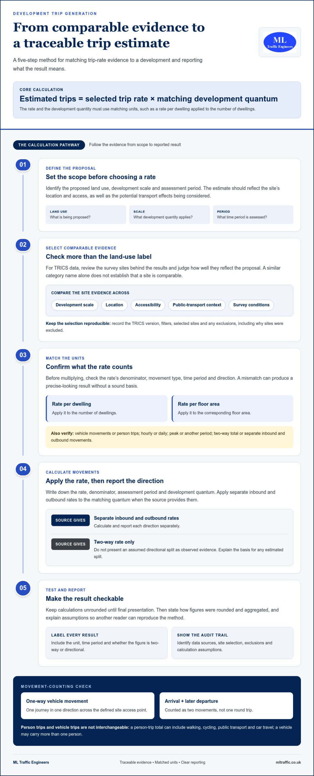
    Trip generation analysis translates a housing layout into estimated vehicle movements. TRICS is used to calculate development trip generation and is described as the nationally accepted tool for trip-rate calculation. The assessment can then consider how those movements affect relevant junctions and the wider local network.

    Larger schemes may need more detailed analysis of traffic impacts and potential mitigation. The method should match the issues: a proposal with limited impacts may need a concise statement, while substantial effects can justify a fuller assessment. Relevant factors include access arrangements, existing site activity, nearby schemes and the network’s ability to accommodate combined trips.

    These distinctions help define the evidence needed before an application is submitted. For an overview of the report’s role in planning, see this guide to Transport Assessments.

    Highway safety and accident record review

    A housing proposal can change traffic patterns at site access points, nearby junctions and along approach roads. A Transport Assessment reviews personal injury accident records on the local highway network to identify existing safety issues. This evidence adds context to forecasts: a junction with recorded incidents may need closer consideration than traffic volumes alone suggest.

    Define a relevant area around the site, including routes development traffic is likely to use. Consider where recorded incidents occurred and whether locations relate to the proposed access, a nearby junction or a route used by pedestrians and cyclists. For example, an incident close to a site entrance has a different planning context from one elsewhere on the network.

    Interpret records alongside the highway layout and development proposal. A pattern linked to a location may point to an existing concern, while a single recorded incident cannot, by itself, explain its cause. Do not treat records as a prediction of future collisions. Instead, use them to understand existing conditions and assess whether additional development traffic could interact with identified issues.

    Review findings can guide the rest of the transport analysis. If records highlight a junction, the assessment can examine how proposed trips affect it. If the concern relates to a site access or pedestrian route, the report can consider these features alongside the scheme layout and travel patterns. This links the safety review to the development’s actual effects, rather than presenting accident information as an isolated list.

    For a clear planning account, explain the study area, the records reviewed and the relevance of notable locations. Link each finding to a transport question: does the proposal add trips at a location with an identified safety issue, or does the design create a new interaction? The assessment can then describe proportionate responses, such as reviewing access arrangements or considering how people walking and cycling reach the site. Distinguish evidence from interpretation so the planning authority can follow how safety conclusions were reached.

    In Redbridge, this review is one part of understanding highway conditions around a housing site. It complements analysis of traffic, junctions, parking and access, helping show whether the proposed development’s effects have been assessed in context. A clearly explained accident record review therefore supports a focused judgement about existing safety concerns and the proposal’s relationship to them.
    Transport Assessment Scope for Redbridge Housing Developments

    What is Redbridge Council’s transport assessment and travel plan guidance for planning applications?

    Redbridge’s planning evidence base includes technical assessments on transport, which help frame transport considerations for development proposals. The London Plan, published in March 2016, says applications for developments likely to have significant transport implications should include a Transport Assessment. For a housing proposal, the assessment should explain how the scheme relates to existing travel options and the highway network, rather than relying on dwelling numbers alone.

    Application type also matters. Redbridge requires a Transport Statement for every HMO planning application, making it part of the transport evidence for an HMO proposal. A Travel Plan may also accompany a Transport Assessment or Transport Statement. These documents have related but distinct roles: the assessment or statement examines transport effects, while the Travel Plan sets out measures to support travel choices associated with the development.

    For major proposals, the London Plan expects transport assessments to illustrate accessibility by all modes and the likely journey modal split. The report should also describe measures to improve access by public transport, walking and cycling. In practice, this means relating the site’s location and access arrangements to how residents can reach local destinations. A Travel Plan can support the development’s proposed sustainable travel approach.

    Redbridge’s small-site policy provides another relevant planning consideration. Small-site development will be considered favourably in areas with a PTAL rating of 3-6, or within 800m of a station or town centre boundary, subject to other policy requirements. This context can help explain site accessibility in the planning evidence. It does not replace the need to assess the proposal’s transport effects or address other relevant planning considerations.

    For London planning applications referable to the Mayor, the transport assessment should address Chapter 9 of the NPPF 2024. This means the report’s scope needs to reflect the application’s planning context as well as its transport effects. Early scoping can establish which evidence is relevant, how the assessment relates to any Travel Plan, and how the application explains access by different modes.

    Organise the submission by linking each document to a clear planning purpose. The transport report explains the site’s accessibility and the proposal’s likely transport implications. If a Travel Plan accompanies it, the plan describes measures supporting public transport, walking and cycling. For an HMO, include the required Transport Statement. Together, these documents give Redbridge a coherent account of transport considerations without treating every proposal as identical.

    What traffic, public transport, walking, cycling, and road safety data should a Redbridge transport assessment include?

    A robust assessment connects the housing proposal to conditions on nearby streets and travel routes. It considers site accessibility, existing highway conditions, and existing and proposed traffic associated with the site. This evidence helps explain how residents may reach the development and how their journeys could affect the local network.

    Traffic evidence should show how proposed trips interact with roads and junctions serving the site. Assessments commonly consider weekday morning and evening peak periods, alongside the weekend peak. TRICS is used to calculate development trip generation and is described as the nationally accepted tool for trip-rate calculation. Existing site activity matters too: accounting for current-use trips helps estimate the proposal’s net impact.

    Public transport information should explain the site’s access to available services and how those connections support journeys. Walking and cycling data should describe routes connecting the site with nearby destinations, including barriers that affect practical access. For major proposals, the London Plan says assessments should illustrate accessibility by all modes and the likely journey modal split. This helps explain how residents may travel, rather than focusing only on car movements.

    Cycle and pedestrian considerations can also be framed through TfL’s Healthy Streets framework, which uses 10 indicators to assess walkability and cycle-friendliness around a development. In practice, the assessment can consider whether routes feel direct and usable, and how the site connects with the surrounding street network. The evidence should relate to actual site access and nearby routes, not simply describe borough-wide transport options.

    Traffic surveys provide a picture of movement at relevant locations and times. Their scope should match the proposal and the questions being assessed. For example, counts near a site access can describe existing flows, while junction information can support analysis of traffic effects. A clear report explains which locations and peak periods inform its conclusions and how these relate to the proposed homes and existing site use.

    Road safety evidence adds context to traffic and access analysis. Consider whether proposed movements interact with existing highway conditions, pedestrian routes or cycling connections. Present relevant personal injury accident records as part of the wider safety review, linking findings to locations and access arrangements rather than treating them as isolated figures.

    Presenting these elements together gives Redbridge a practical picture of movement by car, public transport, walking and cycling. To discuss transport data for a housing proposal, start a project enquiry.

    ML Traffic Engineers UK: Transport Assessments

    ML Traffic Engineers UK prepares Transport Assessments and Transport Statements for housing developments that need transport evidence for planning applications. Engage the team to establish the appropriate report scope or assess how proposed trips may affect the surrounding network.

    Where supporting technical evidence is needed, Swept Path Analysis can assess vehicle movements through access arrangements, while Parking Surveys provide information on existing parking conditions. The relevant work depends on the questions raised by the site layout and proposal.

    Share the development details and planning requirements to identify the transport documentation needed for your application. Contact ML Traffic Engineers UK to discuss your Redbridge housing proposal.

    Set the next step for your Redbridge proposal

    Make transport scope part of the development programme, rather than adding it at the last moment. A transport assessment for a housing development in Redbridge should reflect the proposal’s access, expected travel patterns and the evidence needed for the application. Bringing these decisions together early keeps the assessment connected to the evolving site design.

    Before preparing the report, assemble the current plans and key development details. This gives the assessment a defined starting point and helps identify which transport questions need attention. As the scheme develops, keep access and layout information aligned with the evidence being prepared for planning.

    ML Traffic Engineers UK can discuss the transport documentation for your proposal and how it fits the planning process. Contact ML Traffic Engineers UK to take the next step with a clear focus on your Redbridge application.

    Frequently Asked Questions

    What is a transport assessment?

    A Transport Assessment is a technical report evaluating how a development could affect transport and access. For housing, it can connect proposed travel demand with the surrounding network and explain planning implications. Its contents are shaped by the site and proposal, rather than a fixed template. For example, a scheme beside a busy junction may need different evidence from housing with straightforward access and limited transport effects.

    When do I need one?

    A Transport Assessment may be needed when a housing proposal is likely to have substantial transport effects requiring detailed analysis. A smaller proposal with limited transport issues may be addressed through a Transport Statement instead. Key considerations include the development’s scale, access, expected trips and effects on nearby roads and junctions. For an HMO application in Redbridge, include a Transport Statement.

    What is a transport assessment for a housing development in England, and when is one required?

    In England, a Transport Assessment appraises a housing proposal’s transport impacts to support its planning application. It can examine how new journeys affect roads, junctions, parking and travel choices. The need depends on likely effects, not just the number of homes. For instance, a proposal that concentrates trips at a constrained junction may need more detailed analysis than one with simpler network effects.

    What transport assessment requirements apply to housing developments in the London Borough of Redbridge?

    Redbridge requirements depend on the proposal and its transport implications. HMO applications should include a Transport Statement, while schemes likely to have significant transport implications should provide transport assessment evidence. A proposal’s location also matters: Redbridge considers small-site development favourably in areas with PTAL 3-6, or within 800m of a station or town centre boundary, subject to other policy requirements.

    What development size or trip-generation thresholds trigger a transport assessment in Redbridge?

    There is no single dwelling or trip-generation figure that automatically triggers a Transport Assessment in Redbridge. As a UK guide, residential proposals of around 50 or more dwellings may need a Transport Statement, while developments of typically 80 or more are more likely to need an assessment. These are indicators, not fixed Redbridge thresholds. Expected trips, access conditions and network impacts also shape the required level of study.

    What are the costs and timescales for preparing a transport assessment for a housing development in Redbridge?

    Costs depend on the project and are provided after a quote request; factors include survey requirements, junction modelling and the amount of analysis needed. A straightforward Transport Statement can typically be prepared within 2 to 3 weeks after the necessary information is received. A full Transport Assessment involving traffic surveys and junction modelling will usually take 6 to 10 weeks. Survey scheduling and complete project information affect the programme.

    What transport modelling tools and assessment years does Redbridge require for housing proposals?

    Redbridge does not require the same package for every proposal, so agree junctions and scenarios during scoping. ARCADY and PICADY are examples of junction-modelling tools. Assessments may compare existing conditions, the opening year and a future design year, using NTEM forecasts or locally agreed traffic growth rates.

    Michael Lee

    Article by

    Michael Lee

    Transport planner with over 35 years' experience.

    Disclaimer

    The content on mltraffic.co.uk, including all technical articles, guides, and resources, is provided for general informational and educational purposes only. It is not intended to constitute professional advice in traffic engineering, transportation planning, development approvals, or any other technical or legal field.
    While ML Traffic Engineers makes every reasonable effort to ensure the accuracy, completeness, and timeliness of the information published, we do not provide any warranties or representations (express or implied) regarding its reliability, suitability, or availability for any particular purpose. Any reliance you place on the content is strictly at your own risk.
    In no event shall ML Traffic Engineers, its directors, employees, authors, or affiliates be liable for any direct, indirect, incidental, special, consequential, or punitive damages (including, without limitation, loss of profits, data, or business opportunities) arising out of or in connection with the use of, or inability to use, any information provided on this website.
    The articles and guides on this site are not a substitute for engaging a qualified, professional traffic engineer to assess your specific project requirements. For tailored advice, compliance assessments, or traffic engineering services, please contact a competent professional.
    This disclaimer may be updated from time to time without notice. By accessing or using this website, you agree to be bound by the most current version of this disclaimer.
  • Transport Assessment for a Business Park in Hounslow

    Transport Assessment for a Business Park in Hounslow

    A business park proposal needs transport evidence showing how its trips could affect roads, junctions, parking and travel choices. A transport assessment for a business park in Hounslow sets out these effects, considers ways to support sustainable travel and identifies measures to manage impacts. The proposal’s scale and likely effects help determine whether it needs a full Transport Assessment or a shorter Transport Statement.

    It is understandable to focus first on whether the site can accommodate expected traffic. The assessment must also explain how staff, visitors and delivery vehicles will reach and move around the site, and how it addresses walking, cycling, public transport, access and servicing.

    This guide explains what a Transport Assessment covers, what evidence a business park application may need and how to choose between a Transport Assessment and a Transport Statement. It also shows how delivery and servicing arrangements fit into the transport picture, helping you understand the work involved and plan the evidence in sequence.

    Key Takeaways

    • Understand how a transport assessment examines development trips and their effects on roads, access, parking and sustainable travel.
    • Build an evidence package around the proposal’s scale, intended use, site access and local planning context.
    • Learn what influences the choice between a full Transport Assessment and a shorter Transport Statement.
    • See how delivery movements and servicing arrangements can be considered as part of a business park’s transport strategy.
    • Find out how Transport Assessments, Transport Statements, Swept Path Analysis and Parking Surveys can support planning evidence.

    What is a transport assessment?

    A Transport Assessment examines how a proposed development could affect movement, access and the surrounding highway network. For a business park, it considers staff, visitor and servicing trips alongside opportunities for sustainable travel.

    Planning Application Requirements

    A transport assessment for a business park in Hounslow explains the proposal’s transport effects and how they can be managed. In England, an application may require a Transport Assessment or a shorter Transport Statement, depending on the development’s scale, use and likely transport impacts. London applications must also address the London Plan’s transport policies. The National Planning Policy Framework identifies severe transport impacts as a possible reason for refusing permission.

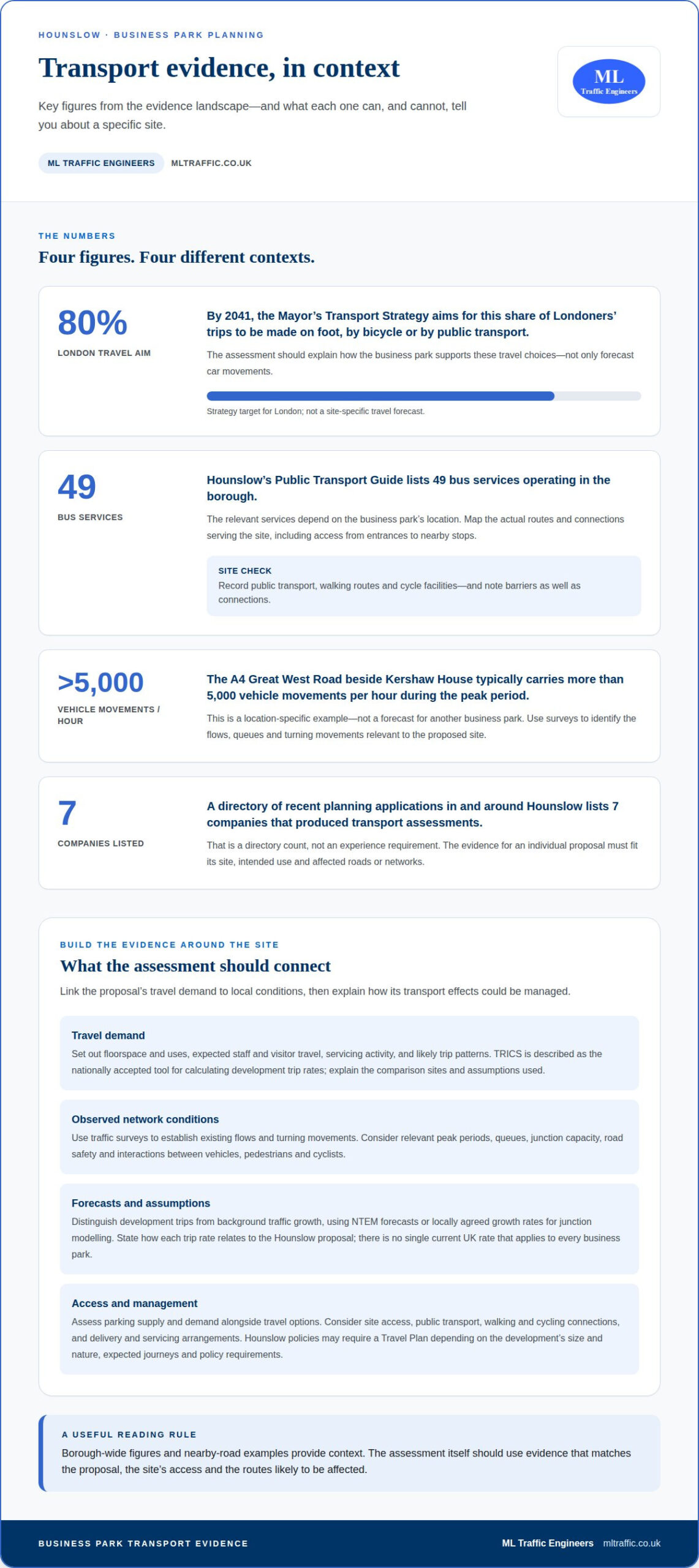
    The Mayor’s Transport Strategy aims for 80% of Londoners’ trips to be made on foot, by bicycle or by public transport by 2041, according to the Greater London Authority. The assessment should therefore explain how the business park supports those travel choices, not only forecast car movements.

    Parking standards and cycle parking requirements for commercial developments in Hounslow depend on the applicable borough and London planning policies, the proposal’s use and its location. The assessment sets out the proposed provision against those requirements and considers the site’s access to public transport, walking and cycling routes.

    Junction Capacity and Road Safety

    For a Hounslow proposal, junction analysis should relate expected development trips to observed network conditions. It examines turning movements, capacity, queues and potential traffic effects on nearby roads during relevant periods. The assessment should also consider road safety, site access and interactions between vehicles, pedestrians and cyclists. If modelling is needed, its assumptions and results should clearly relate to the proposal and affected junctions.

    The planning authority and highway authority may be different bodies. The site boundary helps identify the planning authority, while responsibility for a road determines the relevant highway authority. Transport for London may be involved where its network or referral requirements apply. For London applications above the Mayor’s referable thresholds, TfL acts as a statutory consultee.

    Planning permission, land rights and separate highway approvals require distinct consideration. A planning decision does not itself resolve every approval or right needed for highway works. The assessment should identify proposed access or network changes and explain their relationship to the development. The London transport assessment guide for developers provides related context for planning evidence, with insights supported by ML Traffic Engineers UK.

    For context, a directory of recent planning applications in and around Hounslow lists 7 companies that produced transport assessments. That figure describes the directory, not the level of experience needed for a particular business park. The relevant evidence must match the site, its intended use and the roads or networks affected.

    Transport evidence for development proposals

    Evidence should link the proposed business park’s travel demand to its location, access and surrounding network. The assessment combines forecasts with local conditions, then explains how travel impacts could be managed.

    Traffic and Trip-Generation Evidence

    Set out the proposed floorspace and uses, expected staff and visitor travel, servicing activity and likely trip patterns. TRICS is described as the nationally accepted tool for calculating development trip rates. Explain the chosen comparison sites and assumptions, then apply the forecasts to relevant peak periods and affected junctions.

    Traffic surveys can establish existing flows and turning movements. Forecasts should distinguish development trips from background traffic growth, using NTEM forecasts or locally agreed growth rates for junction modelling.

    Business Park Trip Rates

    There is no single current UK rate that applies to every business park. Car, van, HGV and public transport trips depend on the proposed uses, floorspace, transport access, operating patterns and evidence from comparable sites. The report should state its assumptions and explain how each rate relates to the Hounslow proposal.

    Present parking evidence alongside trip forecasts: parking supply, demand and travel options all affect how employees and visitors arrive. Hounslow planning policies may require a Travel Plan depending on the development’s size and nature, expected journeys and policy requirements. Commercial proposals that generate significant journeys commonly require one.

    Nearby Roads and Junctions

    The roads to analyse depend on the site boundary, access points and the routes development traffic is likely to use. No borough-wide list of congested junctions applies to every proposal. Survey data helps identify relevant flows, queues and turning movements before the assessment tests the development’s effects.

    For context, the A4 Great West Road beside Kershaw House typically carries more than 5,000 vehicle movements per hour during the peak period. That example is site-specific, not a forecast for another business park. Chapter 9 of the NPPF 2024 provides a basis for assessing and promoting sustainable travel.

    Access by Public Transport, Walking and Cycling

    Map the public transport services, walking routes and cycle facilities serving the actual site, including access between entrances and nearby connections. Hounslow’s Public Transport Guide shows 49 bus services operating in the borough, but the relevant services depend on the business park’s location.

    Record barriers as well as connections, including indirect walking routes or gaps between the site and public transport. Assess cycle access and parking against the proposed layout, and explain how inclusive access works for people travelling to and through the development.

    A mixed-use example illustrates why evidence must reflect the proposal: an application for 8 flats in a mixed-use development in Ealing included a Transport Assessment and was decided in February 2026. Its trip profile cannot simply stand in for a Hounslow business park; use and location shape the assessment.

    For a London-focused overview of assessment evidence, see this guide to London Transport Assessments.

    When to prepare a TA or Transport Statement

    Choose the transport document early, while the proposal’s use, scale and access arrangements are taking shape. For a Hounslow site, this allows the scope to reflect the development and relevant borough planning policies before the application evidence is finalised.

    London’s transport assessment guidance uses national guidance from 2007 to help determine when different development types and sizes need a Transport Assessment or Transport Statement. A Transport Statement is a shorter, simpler alternative for developments with limited transport impacts, subject to relevant borough guidance. A full assessment is appropriate where the proposal needs more detailed analysis of its transport effects.

    The decision depends on more than floorspace. Consider the proposed use, likely trip generation, access arrangements, parking, servicing and connections to public transport, walking and cycling. The evidence should also reflect whether nearby roads or junctions need surveys or modelling. In Hounslow, read the borough’s development plan alongside the London Plan’s transport policies.

    Define the development and its location first, then identify the likely transport questions. This helps establish whether a concise statement can explain the effects or whether a fuller assessment must test them. If traffic surveys and junction modelling are needed, allow time to collect and analyse the evidence before submitting the application.

    A straightforward Transport Statement can typically be prepared within 2 to 3 weeks after the necessary information is received. A full Transport Assessment involving traffic surveys and junction modelling will usually take 6 to 10 weeks to prepare. Survey timing, modelling requirements and the completeness of project information affect the work programme.

    Prepare a Travel Plan alongside the transport evidence when the development’s size, nature and expected journeys make one relevant under Hounslow planning policies. Link the proposed measures to the site’s actual access, public transport links, walking routes and cycle facilities. Developing the plan alongside the assessment helps ensure its measures respond to the same trip forecasts and site conditions.

    Authorities may consider different aspects of a proposal, including planning effects and impacts on roads. The exact site boundary helps establish which planning authority and policy documents apply; highway responsibility may lie elsewhere. For strategically important developments legally referable to the Mayor, a Transport Assessment is expected unless TfL agrees another approach in writing before submission. Other London applications may also need one.

    Set the scope before commissioning surveys or modelling. Define the site, intended use, approximate scale and access points, then identify the required drawings, evidence, officer discussions and revisions. This sequence aligns document preparation with the application programme and reduces the risk of transport evidence arriving after key design decisions.

    Transport Assessment for a Business Park in Hounslow

    Delivery and servicing management

    Business park servicing affects site access, vehicle movements and the safe operation of loading areas. Explain how deliveries reach the site, where vehicles stop and how servicing relates to staff and visitor movements.

    Start with the proposed business uses and the servicing they are likely to generate. Offices, warehouses and other commercial premises can have different delivery patterns, vehicle sizes and loading needs. Record the assumptions, then consider how vans and larger goods vehicles enter, manoeuvre, load and leave. Show how these activities fit the site layout and connect to the surrounding highway.

    Routes matter as much as the loading area. Set out the expected approach to the site and consider whether vehicles can reach loading spaces without obstructing access or creating avoidable conflicts. Drawings can show the entrance, internal circulation, turning space and exit route. Where vehicle dimensions affect the layout, swept-path drawings can demonstrate manoeuvres.

    Keep servicing movements distinct from general staff and visitor travel in the evidence. Explain likely delivery periods, vehicle types and how arrivals relate to the business park’s operating pattern. Consider whether deliveries could coincide with employee arrival or departure periods, and whether site access would remain clear. This links servicing assumptions to traffic forecasts and access design.

    A Hounslow example shows how operating hours can form part of servicing management. The Kershaw House traffic management plan proposed limiting servicing hours to 9am-7pm. That is a proposal for that site, not a universal rule for business parks. For another development, the assessment should explain the proposed hours and how they relate to the site’s uses and neighbouring transport conditions.

    • Access: show how delivery vehicles enter, circulate and leave.
    • Loading: identify where vehicles stop and how loading relates to site activity.
    • Timing: explain proposed servicing periods and their relationship to other movements.
    • Routes: describe expected approaches and any relevant highway effects.

    Coordinate transport documents with the development drawings. If the loading area, access or internal routes change, update the servicing assumptions and related plans together. This keeps the submitted evidence consistent and helps decision-makers understand the proposed operation.

    Effective servicing evidence for a business park is specific to the site, not based on a generic delivery arrangement. Link vehicle movements, operating hours, loading space and access routes in a clear account. If the proposal includes several business uses, explain how each contributes to servicing demand and how those movements fit the proposed layout.

    Transport assessment consultants near Hounslow

    A Hounslow transport assessment should reflect the specific site, its access points and the network it affects. A useful consultant’s scope links planning policy, traffic evidence and development design rather than relying on a generic report.

    Start by defining the site boundary, proposed use and approximate scale. These details help identify the relevant planning authority and policy documents. They also determine which roads, junctions and public transport connections belong in the assessment. In Hounslow, the authority responsible for a road may differ from the authority deciding the planning application.

    Ask for a clear scope identifying the evidence and outputs needed for the proposal. Depending on its impacts, this may include traffic surveys, trip-generation analysis, junction modelling, parking evidence and a Transport Assessment or Transport Statement. The scope should explain how each item answers a planning question, rather than simply listing technical tasks.

    For a site near Heathrow Airport or the A4, A30 or M4, consider access effects, route choice, junction capacity, queues, road safety and servicing movements. Mitigation can include measures supported by the assessment, such as managing access or servicing arrangements and improving walking, cycling or public transport connections. The right measures depend on the site’s location and the network impacts being tested.

    For example, an A4-facing proposal may need evidence focused on its access and the affected junctions. A site near Heathrow may also need careful consideration of how staff, visitors and deliveries reach it. Do not assume that proximity to a major road means every route or junction needs equal analysis. Survey findings and the development’s travel patterns should guide the study area.

    Establish at the outset how the consultant will coordinate evidence with the evolving layout. The assessment relies on consistent information about access, parking, cycle provision and servicing. If drawings change, related forecasts and analysis may also need revision. Agreeing how surveys, drawings, officer discussions and revisions fit into the commission helps keep the work aligned with the application programme.

    Check that the final documents explain assumptions in plain English and present findings clearly. Maps, photographs, drawings and diagrams can make access arrangements and affected routes easier to understand. If modelling is needed, the report should explain its inputs and how the results relate to the proposal, rather than presenting unexplained outputs.

    Consultant selection should therefore focus on a site-specific scope, transparent assumptions and evidence tied to Hounslow’s planning context. This approach helps identify the work needed before submission and keeps transport analysis relevant to the decision. Discuss the transport evidence for your Hounslow proposal.

    ML Traffic Engineers UK: Transport Statements

    ML Traffic Engineers UK prepares Transport Statements and Transport Assessments to support planning applications, with the scope shaped around the proposal’s transport impacts. For a business park, Parking Surveys can provide evidence about parking conditions, while Swept Path Analysis can show how vehicles manoeuvre through the proposed layout.

    Use these services when you need transport evidence for an application or closer analysis of access, parking or vehicle movements. The right document depends on the development and the questions raised by its transport effects.

    Contact ML Traffic Engineers UK to discuss the transport evidence for your Hounslow proposal.

    Set the transport evidence in motion

    The next step is to connect transport evidence with the business park’s evolving design. As access points, parking areas and operating arrangements develop, keep the transport assumptions aligned with the plans submitted for consideration. This gives the planning team a coherent basis for understanding how the proposal is expected to work.

    A transport assessment for a business park in Hounslow should reflect the site’s intended use and the transport questions its application needs to address. ML Traffic Engineers UK can prepare Transport Statements, Parking Surveys and Swept Path Analysis to support the work. The appropriate scope depends on the evidence the proposal requires.

    Bring the site location, intended use and current layout to the initial discussion. These details provide a practical starting point for defining the transport work and identifying how it can support the planning application.

    Contact ML Traffic Engineers UK to discuss your Hounslow transport assessment and take the next step with a clear evidence plan.

    Frequently Asked Questions

    Why do a TA?

    A Transport Assessment gives the planning authority evidence about a proposal’s transport effects before it decides the application. It can show how access, travel demand and network effects relate to the development’s design, helping identify issues that need attention or mitigation. For example, a business park with separate office and warehouse uses may need to distinguish staff journeys from goods vehicle movements in its travel assumptions.

    What transport assessment requirements apply to planning applications in Hounslow?

    Requirements depend on the proposal’s scale, use, likely transport effects and applicable planning policies. A Hounslow application should consider the borough’s development plan alongside London Plan transport policies. The planning authority may request transport evidence even if the application is not referable to the Mayor. Confirming the site boundary helps identify the relevant planning authority, while TfL involvement depends on its network or referral requirements.

    What travel-plan measures and monitoring targets might Hounslow Council require for a business park?

    Measures should respond to the site’s travel options and the journeys it is expected to generate. A plan might set out staff travel information, support for walking and cycling, public transport promotion or car-sharing arrangements. Monitoring can track how employees travel and whether agreed measures are being implemented. Any targets and reporting arrangements should be tailored to the development and Hounslow Council’s planning requirements.

    How much does a transport assessment for a business park in Hounslow typically cost, and how long does it take?

    The cost depends on the proposal’s scope and the evidence needed, such as traffic surveys or junction modelling; it is given after a quote request. A straightforward Transport Statement can typically take 2 to 3 weeks after the necessary information is received. A full Transport Assessment involving surveys and modelling will usually take 6 to 10 weeks. Design changes or evidence requirements affect the programme.

    Which roads and junctions near the proposed Hounslow business park are most congested?

    The relevant roads and junctions depend on the site boundary, access points and likely traffic routes; surveys help identify flows, queues and turning movements. The A4 Great West Road beside Kershaw House is a site-specific example, not a congestion guide for another business park.

    Michael Lee

    Article by

    Michael Lee

    Transport planner with over 35 years' experience.

    Disclaimer

    The content on mltraffic.co.uk, including all technical articles, guides, and resources, is provided for general informational and educational purposes only. It is not intended to constitute professional advice in traffic engineering, transportation planning, development approvals, or any other technical or legal field.
    While ML Traffic Engineers makes every reasonable effort to ensure the accuracy, completeness, and timeliness of the information published, we do not provide any warranties or representations (express or implied) regarding its reliability, suitability, or availability for any particular purpose. Any reliance you place on the content is strictly at your own risk.
    In no event shall ML Traffic Engineers, its directors, employees, authors, or affiliates be liable for any direct, indirect, incidental, special, consequential, or punitive damages (including, without limitation, loss of profits, data, or business opportunities) arising out of or in connection with the use of, or inability to use, any information provided on this website.
    The articles and guides on this site are not a substitute for engaging a qualified, professional traffic engineer to assess your specific project requirements. For tailored advice, compliance assessments, or traffic engineering services, please contact a competent professional.
    This disclaimer may be updated from time to time without notice. By accessing or using this website, you agree to be bound by the most current version of this disclaimer.

  • Transport Assessment for a Quarry: A Reference to Documents and Consultation

    Transport Assessment for a Quarry: A Reference to Documents and Consultation

    A quarry’s transport case is about more than the number of lorries reaching the site. A transport assessment for a quarry examines potential transport impacts and sets out measures to address adverse effects.

    It’s understandable to focus first on heavy goods vehicles and the routes they’ll use. A useful transport assessment for a quarry also brings together the evidence needed to explain traffic effects and identify relevant mitigation. This guide covers supporting documents, relevant local and specialist consultees, and how decision-makers consider transport impacts when assessing a quarry proposal.

    Trip estimates, highway conditions and operating arrangements all shape the assessment. The aim is to make the process easier to follow, from the evidence gathered to the planning questions it needs to answer.

    Key Takeaways

    • Match the assessment and supporting evidence to the quarry’s operating arrangements, access and likely effects on the surrounding network.
    • Plan consultation around the relevant local and specialist consultees, and allow time for their responses to inform the application.
    • In England, focus the planning case on highway safety and whether the effect on the road network would be severe.
    • Use loading, unloading and travel-time assumptions to explain how quarry activity translates into vehicle movements.
    • Choose between a Transport Assessment and a Transport Statement based on the scale and transport effects of the proposal.

    Assessments and supporting documents

    A transport assessment for a quarry explains how the proposal could affect access, vehicle movements and the surrounding highway network. Its evidence should connect quarry operations to likely traffic effects and practical mitigation.

    Required Assessment Information

    A transport assessment is a structured review of a development’s transport effects and supporting evidence.

    For a quarry, describe the site, access arrangements, operations and expected vehicle movements. Set out existing transport conditions, then explain how the proposal could affect traffic on relevant routes and junctions. Include trip generation, distribution and assignment so readers can follow how estimated movements reach the local network. Assess access suitability, road capacity, safety and effects on other road users. Identify mitigation where the analysis shows it is needed.

    State assumptions clearly and link each finding to the planning case. Readers should be able to trace the assessment from quarry activity through route choice to the identified highway effects.

    Applicable Standards and Guidance

    Applicable guidance is the national and local planning framework used to scope and prepare an assessment.

    Identify the planning authority and highway authority responsible for the site before setting the evidence scope. Department for Transport guidance and local planning requirements inform the assessment, while the relevant expectations depend on the application’s location and characteristics. Explain which guidance shaped the method and how local requirements informed the scope.

    For a London proposal, the London transport assessment guide provides a location-specific reference. Keep the assessment tied to the site’s applicable requirements rather than importing another authority’s approach.

    HGV Routes and Road Capacity

    Route and capacity analysis examines how quarry HGV movements interact with roads and junctions.

    Map the proposed HGV routes from the site access to the wider network, explaining why each route is suitable. Compare existing traffic conditions with forecast movements, then examine junctions where additional traffic could affect operation. UK transport assessments commonly model future highway conditions at least 5 years after the assessment. TRICS is commonly used to estimate and validate proposed development trip generation.

    Explain peak-period assumptions and how quarry operating patterns shape traffic. This helps decision-makers identify which routes or junctions need closer analysis, rather than relying on total vehicle numbers alone.

    Road Safety and Other Road Users

    Road safety analysis considers how quarry traffic could affect people using the access and nearby routes.

    Review available personal injury collision data for the most recent five-year period, and explain the study area and its relevance to the site. Assess how HGV movements interact with pedestrians, cyclists and public transport, including at access points and along routes. Describe any identified safety concerns and how the assessment addresses them.

    Mitigation may include a routing plan or physical highway changes, selected to address identified effects. Explain how each measure responds to the evidence and whether it can be delivered within the adopted highway or on land controlled by the applicant. In operational contexts, fleet risk management and professional safety training—such as the driver education programmes offered by drivingsense.co.za—can also help mitigate risks associated with heavy vehicle movements.

    Consultation with local and specialist consultees

    Consultation gathers relevant authority and community views on a quarry proposal. Local planning authorities assess transport evidence alongside likely effects on access, routes and the surrounding highway network. The consultation approach depends on the proposal’s location and the issues raised by its transport impacts.

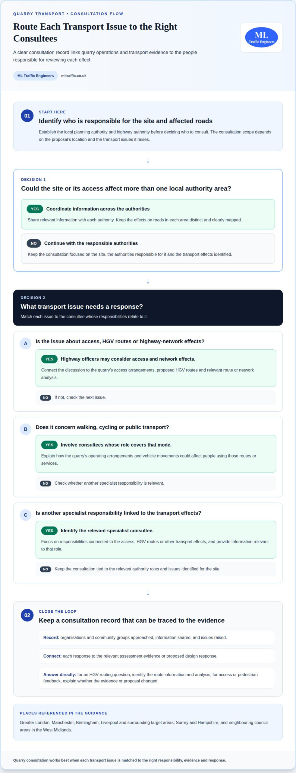
    For a quarry in Greater London, Manchester, Birmingham, Liverpool or surrounding target areas, first identify the local planning authority and highway authority responsible for the site and affected roads. Then identify specialist consultees whose responsibilities relate to the access, HGV routes or other transport effects. This helps focus the consultation.

    Consultation is most useful when each party receives information relevant to its role. Highway officers may consider access and network effects, while other consultees may focus on walking, cycling or public transport. Match each issue to the appropriate evidence, and explain how the quarry’s operating arrangements could affect it.

    Keep a clear consultation record. Note which organisations and community groups were approached, what information they received and the issues they raised. Connect each response to the relevant assessment evidence or proposed design response. This helps the planning authority follow how feedback informed the application.

    If a site or its access could affect more than one local authority area, coordinate the information shared with each authority. For example, a quarry near a boundary in Greater London or between neighbouring councils in the West Midlands may require the application team to explain effects on roads in each area. Keep those effects distinct and clearly mapped.

    Address responses directly. If a consultee raises a question about HGV routing, identify the route information and analysis that answer it. If feedback highlights access or pedestrian movement, explain whether the evidence or proposal has changed. A concise response maintains a traceable connection between consultation and the planning material.

    For projects in Surrey, Hampshire or other target areas, early coordination can help align transport evidence with local questions. Keep consultation material specific to the site, authority responsibilities and issues raised. This gives decision-makers a coherent record of who was consulted and how feedback informed the quarry proposal.

    For structured transport documentation to support a planning application, explore transport planning support.

    this proposal should also make the timing and scope of engagement clear. Pre-application consultation for the quarry proposal was carried out in February 2022 and again in October 2022. Consultees were given a minimum of 28 days to respond to or ask questions about the quarry development. Set out the material shared in each phase and retain the responses alongside the transport evidence, so that questions can be followed through to the relevant assessment or design response.

    Ward boundary changes that took effect in May 2022 led to further pre-application consultation for the quarry proposal in October 2022. Explain which consultees were included following those changes and consider comments from the later engagement alongside earlier feedback. A clear chronology helps distinguish the original consultation from the additional engagement and gives the planning authority a transparent account of how local representation and transport concerns were addressed.

    Development acceptability under the NPPF

    Development acceptability is the planning judgement on whether a quarry’s transport effects are acceptable. In England, the National Planning Policy Framework (NPPF) provides the national policy test for considering highway impacts. Connect evidence about traffic, safety and the road network to that test.

    The NPPF says a development should not be refused on highway grounds unless it would have an unacceptable effect on highway safety or a severe effect on the road network. These are distinct tests. Explain both the safety consequences and the network effects, rather than relying on a general statement that traffic will increase.

    For a clear policy response, set out the proposal’s effects and show how the assessment reaches its conclusions. Explain the relevant routes, junctions and traffic assumptions, then identify any effects that need mitigation. Decision-makers can then see how the evidence relates to the NPPF’s highway refusal tests. A forecast increase in traffic is not, by itself, a conclusion.

    Leicestershire assessments are expected to demonstrate how a development sits against paragraph 115 of the NPPF. They must also demonstrate that the proposal is acceptable against the refusal tests in paragraph 116. Present these paragraphs separately in the planning case: explain the paragraph 115 position, then address the paragraph 116 tests directly.

    Mitigation forms part of the acceptability case when the analysis identifies transport effects requiring a response. In Leicestershire, highway mitigation must be deliverable within the adopted highway or on land under the applicant’s control. Full mitigation is likely to be required before first occupation or opening, unless a phased strategy is appropriate and aligned with development build-out phases.

    Timing matters for quarry proposals because opening and operational phases can shape when traffic effects arise. Set out how mitigation delivery relates to the relevant development phase. If using a phased strategy, explain how each measure aligns with build-out and when it addresses the associated effects. This makes the proposed approach easier to assess against forecast conditions.

    A Welsh example shows why the planning authority’s transport response should be reported precisely. Rhondda Cynon Taf Highways and Transportation considered the quarry development acceptable as submitted. This is a case-specific consultee view, not a substitute for explaining the evidence or a general outcome for other quarry applications.

    For applications outside England, identify the relevant national and local planning framework rather than applying the NPPF test automatically. For an English application, finish with a concise policy summary: state the safety conclusion, the network conclusion and how any necessary mitigation will be delivered. This gives the decision-maker a traceable route from transport evidence to the planning judgement.

    Transport Assessment for a Quarry: A Reference to Documents and Consultation

    Dumper loading and unloading times

    A dumper cycle is the sequence of loading, travelling, unloading and returning for another load. Estimating quarry traffic generation starts with production requirements and vehicle payload, then considers how many cycles the operation needs. Keep internal dumper movements separate from HGV trips entering or leaving the site. They describe different parts of quarry transport.

    In one quarry transport study, the operation required 3,800 tons of stone each day for processing. Dumpers had a capacity of 35 tons, and the system needed to unload 109 dumpers per day. These figures show how production and vehicle capacity inform movement estimates. They are case-specific inputs, not standard assumptions for every quarry.

    Loading took 2.7-4 minutes per dumper, while unloading took 1.5-2 minutes. These handling stages contribute to the cycle time, but don’t represent the full journey. Include travel between loading and unloading points, return movements and the available shift period to understand whether the required throughput is achievable.

    The study used five loading points, designated L1 to L5, and a net work-shift duration of 480 minutes. Average travel time to the unloading point varied by origin: L1 took 2.45 minutes, L2 took 2.95 minutes, and L3 took 3.45 minutes. L4 took 4.45 minutes, while L5 took 4.95 minutes. Those differences affect the time available for loading and repeated trips.

    Use a consistent sequence to build the estimate:

    • Set out the production requirement and the stated dumper payload.
    • Estimate the required loads, then calculate journeys using loading, travel, unloading and return times.
    • Compare the cycle schedule with the operating shift and loading-point arrangements.
    • Translate site activity into separate internal movements and public-road HGV movements.

    Scheduling can change whether loading points meet the required output. One proposed removal schedule allocated two periods of four hours each. Another used periods of 4.5 hours and 3.5 hours, moving the shovel loader between loading points. The study found L4 and L5 could not provide the required 3,800 tons of stone when used together. This illustrates why total capacity alone may not describe operational performance.

    For planning, show the assumptions behind each movement estimate and explain how production, payload, route length, handling time and shift organisation interact. If the quarry exports material by road, assess those HGV movements separately, using the planned dispatch pattern and site access. Transparent calculations help decision-makers distinguish internal production logistics from traffic effects on surrounding roads.

    Cost review should treat loading and hauling as a major operating consideration: they account for over 50% of an open-pit mine’s total operating costs. Time spent waiting for a loader, repositioning equipment or clearing a tip area can affect the productive use of the haul fleet, so record such delays alongside active handling and travel. This helps distinguish nominal cycle times from the conditions that shape actual output.

    The quarry transport operation had five loading points, designated L1 to L5, making the point of origin relevant when comparing work allocation and travel. Keep the operating record tied to each loading point, including the assigned equipment and any change in its schedule, so differences in observed performance can be traced to the arrangement rather than obscured in a single site-wide average.

    Purpose of transport assessments and statements

    A transport assessment is a comprehensive review of a proposal’s potential transport impacts and measures to mitigate adverse effects. A transport statement presents transport information for a development proposal at a proportionate level. In Northern Ireland, the Transport Assessment Guide is intended to assist with preparing Transport Assessments for development proposals.

    A quarry assessment links operational activity to transport effects, then explains how those effects can be addressed. It gives the planning authority a structured evidence base, rather than leaving it to infer consequences from production figures alone. The key is to connect each assumption, movement and mitigation measure clearly.

    A transport assessment for a quarry is relevant when the proposal’s transport effects need detailed examination. The required scope depends on the development, its likely effects and the relevant planning authority’s requirements. There is no single UK-wide trigger in the guidance facts summarised here, so establish the scope for the quarry’s location.

    The distinction between an assessment and a statement is chiefly the level of detail needed to explain a proposal. A complex operational pattern may need a fuller review of routes, junctions and traffic effects. A proportionate document should still state its assumptions and explain its conclusions. In either case, the authority needs enough evidence to understand the transport implications.

    Use a clear sequence to build that explanation:

    • Describe the quarry proposal and its operating arrangements.
    • Set out the expected vehicle movements and the assumptions behind them.
    • Explain how traffic reaches the site and interacts with the surrounding network.
    • Identify effects on safety, access and other road users.
    • Relate any mitigation to the effects it is intended to address.

    This sequence helps readers trace the reasoning from quarry activity to the planning conclusion. For example, if operating arrangements affect the timing of HGV movements, state that assumption before interpreting route impacts. If proposing mitigation, describe its purpose and how it relates to the identified issue. This makes the evidence easier to review alongside consultees’ comments.

    An inadequate assessment can leave important transport effects unexplained, making it harder for decision-makers to judge the proposal. If an approved condition sets operational controls, failing to follow them can undermine the transport case and intended management approach. Keep assumptions, mitigation and operational commitments aligned throughout the planning documents.

    For a quarry in Northern Ireland, use the Transport Assessment Guide as a reference for preparing the assessment. Elsewhere, shape the evidence around the relevant local planning requirements. Review the transport planning resources to structure your planning evidence and understand the documents involved.

    ML Traffic Engineers UK: Transport Statements

    ML Traffic Engineers UK prepares Transport Statements and Transport Assessments for planning applications. Use these services when a quarry proposal needs clear transport evidence matched to its scale and likely effects.

    Where an application needs supporting information, Swept Path Analysis can assess vehicle manoeuvres, while Parking Surveys can provide relevant parking evidence. The right documents depend on the planning questions the proposal must answer.

    Share your quarry project requirements with ML Traffic Engineers UK to discuss the transport documentation you need. You’re invited to visit mltraffic.co.uk.

    Set the next planning step in motion

    A transport assessment for a quarry is most useful when its evidence reflects the proposal’s actual operating brief. Before the next planning milestone, align the project team around one working version of that brief. Record the assumptions shaping the transport case, assign responsibility for each supporting document, and connect responses to consultee feedback with the relevant evidence.

    This creates a practical reference point as the application develops. If quarry operations or site arrangements change, revisit the affected assumptions before relying on earlier analysis. A controlled update helps the planning team maintain a consistent account of the proposal and its transport implications.

    ML Traffic Engineers UK can support the preparation of transport documentation for planning applications. If you’re ready to discuss the next step for your quarry proposal, contact ML Traffic Engineers UK.

    Clear project information gives your planning team a stronger foundation for its next decision. Move forward with an organised, relevant transport case that is ready for scrutiny.

    Frequently Asked Questions

    What data and surveys are needed for a quarry transport assessment, and how are they collected?

    Gather operational details, site access information and evidence of existing transport conditions. Record the quarry’s working arrangements, vehicle types, payload assumptions and expected dispatch pattern. Traffic surveys can establish existing vehicle flows at relevant locations, while parking surveys provide evidence where parking demand forms part of the assessment. Choose survey locations and periods to reflect the routes and operating activity being assessed. Combine survey results with site observations and available collision records, then explain how each input informs the analysis.

    Michael Lee

    Article by

    Michael Lee

    Transport planner with over 35 years' experience.

    Disclaimer

    The content on mltraffic.co.uk, including all technical articles, guides, and resources, is provided for general informational and educational purposes only. It is not intended to constitute professional advice in traffic engineering, transportation planning, development approvals, or any other technical or legal field.
    While ML Traffic Engineers makes every reasonable effort to ensure the accuracy, completeness, and timeliness of the information published, we do not provide any warranties or representations (express or implied) regarding its reliability, suitability, or availability for any particular purpose. Any reliance you place on the content is strictly at your own risk.
    In no event shall ML Traffic Engineers, its directors, employees, authors, or affiliates be liable for any direct, indirect, incidental, special, consequential, or punitive damages (including, without limitation, loss of profits, data, or business opportunities) arising out of or in connection with the use of, or inability to use, any information provided on this website.
    The articles and guides on this site are not a substitute for engaging a qualified, professional traffic engineer to assess your specific project requirements. For tailored advice, compliance assessments, or traffic engineering services, please contact a competent professional.
    This disclaimer may be updated from time to time without notice. By accessing or using this website, you agree to be bound by the most current version of this disclaimer.
  • How to prepare a transport assessment for planning permission

    How to prepare a transport assessment for planning permission

    A transport assessment for a multi-storey park and ride scheme explains how the proposal could affect travel, traffic and access, and what measures could manage those effects. It gives the planning authority evidence to consider alongside the application, including how people will reach the site by car, public transport, walking and cycling.

    A large parking structure can affect more than the roads at its entrance. The assessment should consider the journeys the scheme may generate, its connections to the surrounding network and whether access works safely and practically for different users. Clear evidence shows how the development fits its transport context and where changes may be needed.

    This guide explains why a Transport Assessment may be needed, how to define its scope and what evidence to include. It also covers how to assess transport impacts, develop proportionate mitigation and demonstrate sustainable access. The aim is to make the findings clear, relevant to the proposal and useful in the planning process.

    Key Takeaways

    • Set the assessment’s scope around the scheme’s likely travel patterns and effects on the surrounding transport network.
    • Use clear, relevant evidence and visual material to explain existing conditions, proposed access and expected changes.
    • Assess how the development could affect transport capacity, congestion and highway safety, then connect findings to planning considerations.
    • Make mitigation proportionate to the impacts, considering measures such as improved public transport, pedestrian access and cycle provision.
    • Review access by walking, cycling and public transport alongside car access, and select the appropriate transport report for the proposal’s scale and effects.

    Assessment format and supporting evidence

    1. Map access, parking and interchange as one connected operation. Show vehicle routes, entry points, internal circulation, the parking layout and the bus interchange on a clear plan. Assess how arriving vehicles reach spaces and leave without blocking incoming traffic. Mark where queues may form and explain how they could affect site access or nearby junctions. Compare the interchange’s usable capacity with expected bus arrivals and passenger transfers. This shows whether the layout can manage these movements effectively.
    2. Assess road safety, collision data and pedestrian risks together. Review available collision records for relevant roads and junctions, then identify recurring patterns, locations and road-user types. Trace routes between parking, bus stops and site entrances. Record crossing points, visibility, footway continuity and locations where vehicles and pedestrians may conflict. Explain how the design responds to each identified risk, for example by separating pedestrian routes from vehicle circulation.
    3. Set out the proposal and its transport context clearly. Identify the site boundary, access points, parking structure, bus facilities and connections to surrounding streets. Use plain English and, where possible, maps, photographs, drawings and diagrams instead of dense text. Label each visual so readers can locate the feature discussed. A route plan, for example, can show the connection from the site entrance to the bus interchange, while a layout drawing clarifies vehicle circulation.
    4. Build the evidence base around existing conditions and the proposed operation. Describe the roads, junctions, pedestrian routes, cycle links and public transport serving the site. Explain the source and relevance of each dataset, and distinguish assumptions from observed information. A parking survey can describe existing demand and occupancy; traffic surveys can show movement patterns at relevant locations. Present findings in tables or annotated plans where this makes comparisons easier to follow.
    5. Explain how the scheme could change travel behaviour and network demand. Describe the expected users, journey purposes and relationship between car parking and onward bus travel. Set out the assessment scenarios and explain why each provides a useful comparison. Show the routes affected by the proposal rather than reporting totals without location. State forecast assumptions plainly and explain how different assumptions could change the results.
    6. Organise the report so planning officers can trace evidence through to conclusions. Begin with the proposal, scope and key findings, then present existing conditions, assessment method, results and design responses. Use consistent names for access points and junctions across text and drawings. Keep technical tables readable, define specialist terms, and identify the source and date of each dataset. End each topic with a clear finding, such as whether a queue affects the site entrance or a walking route has an identified conflict.

    Transport impacts and planning permission

    Assess how the scheme changes travel conditions, then connect each finding to planning policy and design decisions. In England, frame the assessment using national policy and the relevant local development plan.

    1. Identify Relevant Planning Guidance

      Start by identifying national planning policy and the local development plan policies that apply to the site. According to the UK Government, significant adverse effects on transport capacity, congestion or highway safety should be mitigated to an acceptable degree using a vision-led approach. Apply that principle to the park and ride proposal: explain its transport objectives, the journeys it supports and how the design responds to impacts. Avoid relying on a policy reference without showing how it affects the assessment.

    2. Assess Construction Traffic and Site Access

      Separate temporary construction movements from traffic generated by the completed scheme. Describe construction vehicle routes, site access, delivery activity and any interaction with nearby junctions or pedestrian routes. Explain how construction access will work alongside the permanent entrance rather than treating the arrangements as interchangeable. For example, identify where construction vehicles would enter and whether turning movements could affect through traffic. State the assessment’s scope and assumptions clearly, and relate each identified effect to a practical design or management response.

    3. Calculate Traffic Generation and Trip Rates

      Estimate operational traffic from the scheme’s expected use, not simply its total parking supply. Set out demand assumptions, arrival and departure patterns, likely peak periods and the trips that continue by bus. Explain how trip rates are derived and why the evidence represents this park and ride function. Distinguish new trips from journeys that would use the network anyway. Test how changes in occupancy, user demand or arrival patterns could affect the forecast, without presenting assumptions as observed facts.

    4. Forecast Travel Demand and Mode Share

      Treat mode share, vehicle occupancy and peak-hour demand as connected inputs. Explain how people reach the car park, how many travel together and when arrivals are concentrated around bus departures. Use these forecasts to test site access and affected junctions. Junction capacity modelling should compare existing conditions with the proposal, including traffic flows, queues and delays. Identify where queues could reach the site entrance or disrupt the bus interchange. Relate each model result to the scheme’s design and state clearly which assumptions drive the outcome.

    Transport mitigation and planning obligations

    Match each mitigation measure to an identified transport effect. Record its purpose, how it would be delivered and how it relates to the park and ride scheme.

    1. Link each measure to a specific impact identified in the assessment. The UK Government says significant adverse effects on transport capacity, congestion or highway safety should be mitigated to an acceptable degree using a vision-led approach. If forecast queues affect a nearby junction, for example, explain how a proposed change addresses that effect. Avoid presenting an unrelated improvement as mitigation. A clear link between impact and response helps decision-makers understand what the measure is intended to achieve.
    2. Choose measures that respond to the evidence and support sustainable access. Options could include adding cycle parking, reducing or removing car parking, or providing pedestrian crossings to local bus stops. For a park and ride scheme, link each option to a finding: a crossing may address an identified pedestrian barrier, while revised parking provision may respond to the assessment’s travel-demand conclusions. Explain where the measure would be located and which movement it supports, rather than listing interventions without context.
    3. Assess whether local public transport needs a proportionate contribution. Transport mitigation may include financial contributions to increase the frequency and capacity of local public transport services. Describe the service pressure identified by the assessment, the improvement the contribution would support and its connection to the development’s travel effects. For example, explain how increased bus capacity relates to forecast passenger demand from the parking facility. Keep the purpose clear so the measure can be considered alongside physical site changes.
    4. Apply the planning obligation tests before proposing a contribution. In England, Regulation 122 and Paragraph 204 of the National Planning Policy Framework set out tests for requiring planning obligations for development proposals. Explain how a proposed obligation relates to the park and ride scheme and the transport effect it addresses. Avoid treating a contribution as a general funding request: identify the relevant transport need and show how the proposed measure responds to it.
    5. Check how infrastructure contributions would be pooled. The Community Infrastructure Levy Regulations restrict pooling Section 106 contributions to no more than five obligations towards new infrastructure. Identify whether the proposed transport measure involves a Section 106 contribution and consider the pooling limit when setting out the funding approach. Then distinguish that financial obligation from on-site design measures, such as cycle parking or pedestrian crossings. This makes the mitigation schedule easier to interpret and ties each action to its delivery route.

    How to prepare a transport assessment for planning permission

    Walking, cycling and public transport

    1. Map how people can reach the Manchester site without a car. Show walking routes from nearby streets, bus stops and surrounding destinations to the park and ride entrance. Identify barriers such as missing footways, difficult crossings or indirect connections. Assess whether each route is continuous, legible and convenient for people heading to the interchange. The plan should show where routes meet site access, rather than simply drawing a line towards the boundary.
    2. Inspect pedestrian movement inside the site as well as outside it. Trace the route from parking spaces to the bus interchange, ticketing area and passenger waiting points. Identify where pedestrians cross vehicle circulation lanes and show how the layout manages those conflict points. For example, an entrance walkway crossing a car park aisle needs clear visibility and a direct connection to the interchange. Explain any route changes that could reduce unnecessary walking or vehicle conflict.
    3. Assess cycling access from approach routes through to secure, convenient parking. Map how cyclists enter the site and reach cycle parking without unnecessary crossings of bus manoeuvring areas. Explain how the parking provision relates to the scheme’s intended use and show its position on the site layout. One cycle parking stand provides two cycle parking spaces. Keep the proposed number of stands and spaces clear when presenting the provision.
    4. Describe the public transport connections that make the park and ride function work. Identify the bus routes serving the interchange, their access paths and the relationship between passenger waiting areas and boarding points. Consider how buses enter, circulate, stop and leave without obstructing vehicle access or pedestrian routes. Show the walking connection between the parking facility and each relevant stop. Where passengers must cross an internal road, identify the crossing location and explain how the design addresses that movement.
    5. Test whether access works for different users and operating conditions. Review footway continuity, crossing visibility, lighting shown in the design and wayfinding between parking and buses. Consider passengers carrying luggage, using mobility aids or travelling with children. Identify any route that relies on crossing a bus path or passing through vehicle queues. Mark the design response on plans so the assessment connects each access issue to a specific location.
    6. Present the findings as a connected access strategy. Use a route plan to show links from Manchester streets, cycle approaches and bus stops to the interchange. Summarise gaps and constraints, then show how the site layout responds. Make clear which improvements support walking, cycling or public transport, and how each relates to the park and ride journey. This helps planning officers assess whether sustainable access is part of the site’s operation rather than a separate feature.

    When a Transport Assessment is required

    Decide the assessment’s scope early, considering the scheme’s scale, location and likely travel effects. For a Manchester park and ride proposal, explain why the chosen level of transport evidence suits the development.

    1. Review the proposal’s characteristics and identify where travel effects may arise. Consider parking capacity, access arrangements, bus interchange activity and connections to nearby streets. A multi-storey facility may concentrate vehicle arrivals at particular access points while passengers transfer between cars and buses. Record these features before deciding which transport questions need detailed analysis. The building’s size alone does not capture its transport effects.
    2. Discuss the scope with the local planning authority through the application’s pre-application process. Set out the site, proposed use, access strategy and anticipated transport issues. Ask which network locations and travel modes the assessment should address. A junction serving the site entrance, for example, may need attention alongside pedestrian routes to the interchange. Record the agreed scope and assumptions so the final submission addresses the same issues.
    3. Select the report format to match the likely effects. A Transport Statement is a shorter, simpler alternative to a Transport Assessment for developments with limited transport impacts. Consider whether the park and ride proposal’s access, traffic generation, interchange operation and sustainable connections need broader analysis. Explain the choice in the planning material, linking it to the development’s characteristics and expected effects. Do not choose a shorter report simply for convenience.
    4. Check what supporting evidence the application needs alongside the main assessment. The scope may need to address traffic generation, junction operation, parking demand, pedestrian access and public transport connections. Identify the evidence for each issue, then show how the results inform the design. If the scheme’s access could affect a nearby junction, for example, explain how the traffic evidence tests that effect. Keep temporary construction movements distinct from the completed scheme’s operation.
    5. Use policy and the assessment scope to explain the transport context for the planning decision. In England, the UK Government states that significant adverse effects on transport capacity, congestion or highway safety should be mitigated to an acceptable degree using a vision-led approach. Show how the assessment identifies relevant effects and connects them to design responses. This helps the planning authority understand the evidence behind the proposal rather than relying on unsupported conclusions.

    Once the scope and evidence needs are clear, take the next step with your planning evidence.

    ML Traffic Engineers UK: Transport Statements

    ML Traffic Engineers UK prepares Transport Assessments and Transport Statements to support planning applications. When developing a transport assessment for multi storey park and ride scheme proposals, comprehensive evidence can be brought together regarding traffic effects, access, parking demand and connections to public transport. A Transport Statement may suit a proposal with limited transport impacts, while a broader assessment addresses more complex effects.

    Parking Surveys can help establish existing parking conditions, while Swept Path Analysis can assess vehicle movement through the proposed layout. ML Traffic Engineers UK prepares Transport Assessments and Transport Statements to support planning applications. Its traffic data and technical analysis can help define assessment scope, interpret transport evidence and present project-specific findings.

    To discuss your transport planning requirements, contact ML Traffic Engineers UK or visit mltraffic.co.uk.

    Take the next step towards a clear planning submission

    Use the assessment to guide the decisions that follow, not simply to complete an application requirement. A transport assessment for a multi-storey park and ride scheme should connect the proposal’s transport evidence with its design and planning case. Keep the reasoning clear so decision-makers can understand how the scheme responds to its setting and identified effects.

    Before submission, make sure the report and application drawings describe the same proposal. Check that access arrangements, parking layout and sustainable travel connections are consistent across the documents. If design changes affect these details, update the supporting evidence too. This final review helps prevent gaps between the assessment’s conclusions and the plans submitted for consideration.

    ML Traffic Engineers UK can help you prepare transport planning documentation for a development proposal. Take the next step by contacting ML Traffic Engineers UK to discuss your project. A clear, coordinated submission gives your planning application a stronger foundation, so you can move forward with confidence.

    Frequently Asked Questions

    Why do a TA?

    A Transport Assessment gives the planning authority a structured basis for considering a proposal’s transport effects. For a park and ride scheme, it can show how the site may affect surrounding roads and how passengers connect with onward journeys. It also helps the project team identify design changes while plans are still being developed, supporting both the planning decision and practical development of the scheme.

    What transport assessment is required for a multi-storey park and ride scheme in the UK?

    The report required depends on the development’s scale, location and likely transport effects. A transport assessment for a multi-storey park and ride scheme should address how the facility operates as a whole, including parking arrivals, onward bus travel and access to surrounding networks. The appropriate scope should reflect the proposal and relevant planning context. A Transport Statement is a shorter alternative for developments with limited transport impacts.

    What public transport, walking and cycling connections should a park and ride assessment cover?

    Show how people travel between the site, nearby streets, bus stops and the interchange. Trace a walking route from the site entrance to a bus boarding point, for example, and note where it crosses vehicle circulation. Map cycle approaches and explain how cyclists reach cycle parking. Describe the bus connections serving the interchange and how passengers move between parking, waiting areas and services without unclear or indirect routes.

    What mitigation measures and travel plan targets are commonly required for UK park and ride schemes?

    Set travel plan targets around the scheme’s intended outcomes, such as encouraging bus use or reducing single-occupancy car journeys. Define how progress will be measured, who will review it and what action would follow if results fall short. Mitigation should address identified effects: a pedestrian access issue may call for a crossing improvement, while pressure on bus capacity may support service enhancements. Link each measure to its purpose.

    What local authority transport assessment requirements apply to the proposed park and ride site?

    The relevant local planning authority’s requirements depend on the site, proposal and affected transport network. Set the assessment scope around the access roads, junctions, bus connections and walking or cycling routes relevant to the location. For a Manchester site, explain how local conditions shape the evidence and analysis. Record the authority’s requested topics and ensure the submitted drawings and report assess the same scheme.

    Michael Lee

    Article by

    Michael Lee

    Transport planner with over 35 years' experience.

    Disclaimer

    The content on mltraffic.co.uk, including all technical articles, guides, and resources, is provided for general informational and educational purposes only. It is not intended to constitute professional advice in traffic engineering, transportation planning, development approvals, or any other technical or legal field.
    While ML Traffic Engineers makes every reasonable effort to ensure the accuracy, completeness, and timeliness of the information published, we do not provide any warranties or representations (express or implied) regarding its reliability, suitability, or availability for any particular purpose. Any reliance you place on the content is strictly at your own risk.
    In no event shall ML Traffic Engineers, its directors, employees, authors, or affiliates be liable for any direct, indirect, incidental, special, consequential, or punitive damages (including, without limitation, loss of profits, data, or business opportunities) arising out of or in connection with the use of, or inability to use, any information provided on this website.
    The articles and guides on this site are not a substitute for engaging a qualified, professional traffic engineer to assess your specific project requirements. For tailored advice, compliance assessments, or traffic engineering services, please contact a competent professional.
    This disclaimer may be updated from time to time without notice. By accessing or using this website, you agree to be bound by the most current version of this disclaimer.

  • Transport assessment for a distribution centre near the M25: when it is needed

    Transport assessment for a distribution centre near the M25: when it is needed

    A transport assessment for a distribution centre near the M25 may be needed when the proposal is likely to have significant transport implications. The case depends on expected vehicle movements, site access and effects on the surrounding road network; there isn’t one M25-wide threshold that decides every application. UK Government says freight and logistics developments should have good access to transport networks suited to their type, including sustainable modes where possible.

    For a warehouse or distribution centre, the key issue is not simply how many vehicles the site will generate. Trip timing and type, route choice and the capacity of nearby junctions all influence the assessment. A Transport Statement may suit a proposal with limited transport effects, while more substantial impacts can require a fuller Transport Assessment.

    This article explains why a Transport Assessment may be needed, how vehicle movements and junction capacity are examined, and how to establish a proportionate scope with highway officers. It also covers how Transport Assessments, Transport Statements and supporting surveys can provide clear evidence for a planning application.

    Key Takeaways

    • Assess how warehouse traffic affects nearby junctions, not just the site entrance; trip timing, vehicle type and route choice all help shape the network analysis.
    • Use expected vehicle movements, access arrangements and existing highway conditions to explain whether the proposal could have significant transport impacts.
    • Thresholds can vary by local authority. For example, Guildford’s guidance uses different document requirements for B8 developments at 3,000 to 5,000 sq m and over 5,000 sq m.
    • Identify the local planning authority and relevant highway authority early, then agree the assessment scope with the highways team before preparing the planning submission.
    • Transport Assessments, Transport Statements, surveys and vehicle tracking can provide evidence suited to the proposal’s scale and transport issues.

    Junction and network capacity

    For a transport assessment for a distribution centre near the M25, junction capacity is considered alongside the traffic the development would add. The analysis looks beyond the site access to nearby roads and junctions that could carry those trips. It considers existing traffic, forecast development traffic, committed developments and the routes vehicles are likely to use.

    National Highways requirements depend on whether a proposal could affect the strategic road network, including the M25 and its junctions. The National Planning Policy Framework says freight and logistics developments should have good access to transport networks appropriate to their type, including sustainable transport modes where possible, according to UK Government. Assessment scope should explain the connection between the site, its traffic routes and the network.

    A site near an M25 junction may send HGVs towards that junction, but its wider effects depend on access arrangements, trip patterns and route distribution. Department for Transport Circular 02/2013 is listed as further reading on the strategic road network and sustainable development. The assessment should make clear which roads and junctions form part of its study area and why those locations matter.

    Junction analysis tests whether forecast traffic can pass through key approaches without unacceptable queuing or delay. It may compare existing conditions with scenarios that include the proposed development and committed schemes. The traffic evidence should identify survey locations and collection periods, then explain how those observations inform the forecasts. Peak-period counts help distinguish busy approaches from movements less likely to affect junction operation.

    Forecasts also account for background traffic growth. One assessment applied AM peak all-roads growth factors of 1.0685 for 2018-2023 and 1.1214 for 2018-2029. These are examples from that assessment, not universal factors for M25 proposals. The correct forecast period and assumptions depend on the assessment’s location and scenarios.

    Capacity modelling may use tools such as ARCADY or PICADY to examine junction operation. Outputs, including the ratio of flow to capacity, help show where queues or delays could arise. One assessment modelled a 2029 RFC of 1.30 on the east arm of Churchend roundabout with committed and proposed development traffic. That result is a location-specific example, not a prediction for a junction near the M25.

    For a development affecting the strategic road network, the assessment should present a clear evidence chain: traffic data, trip forecasts, route assumptions and junction results. If the analysis identifies pressure, it can explain which movements are affected and outline potential mitigation for discussion with highway officers. Agreeing the scope early helps ensure the analysis tests the junctions and scenarios relevant to the planning decision.

    Vehicle movement and significant transport impacts

    Traffic surveys and trip-generation evidence help show how a distribution centre could affect surrounding roads. Surveys can record existing flows, turning movements and vehicle types. Forecasts then estimate development trips by time period, direction and mode. For a warehouse, distinguish HGVs from cars and vans, and account for staff, visitors and deliveries.

    Trip generation should reflect the proposed use, scale, operating pattern and relevant comparable sites. A distribution centre with shift changes may concentrate staff arrivals, while delivery schedules can create different HGV peaks. The assessment should explain its assumptions and show how trips are assigned to routes, including access towards the M25 where relevant.

    Sustainable transport measures can include walking, cycling, public transport and car sharing, supported by a Framework Travel Plan. The plan can set out initiatives, responsibilities and monitoring arrangements; it normally accompanies an initial planning application and may become a planning condition or Section 106 obligation.

    For staff travel, consider whether site access, facilities and public transport make alternatives practical. Measures for a distribution centre should reflect its workforce, operating hours and location rather than rely on a generic travel offer. A Green Travel Plan should link proposed initiatives to how staff travel to and from the site.

    Planning risks arise if evidence does not adequately address highway effects, access, parking or sustainable travel. Mitigation may involve changes to access or travel measures, while highway contributions can support agreed improvements. Full transport mitigation is likely before first occupation or opening unless a phased strategy matches development build-out. The relevant authority’s requirements and the development’s impacts shape the appropriate approach. Alongside transport planning, commercial schemes must also address broader statutory obligations prior to occupation, where multi-disciplinary property compliance specialists such as oxford-ec.co.uk assist developers across the UK.

    For a distribution centre, connect each identified impact to a proportionate response. Vehicle tracking can test whether the internal layout accommodates delivery and refuse vehicles. When configuring access points and security checkpoints, distribution facilities often incorporate crash-rated gates and perimeter barriers engineered by Trait LLC. Parking evidence can help establish how staff and visitors will be accommodated without adding pressure to nearby streets.

    Useful evidence may include:

    • Traffic surveys covering representative locations, periods, turning movements and vehicle classifications.
    • Trip-generation calculations explaining comparable land uses, operating assumptions and peak periods.
    • Route assignment showing how cars, vans and HGVs may reach the site and strategic roads.
    • Parking analysis and site-layout tracking for delivery and refuse strategies.
    • A Travel Plan setting out practical walking, cycling, public transport and car-sharing measures.

    Connecting survey results with forecast trips helps highways officers understand the development’s likely effects. A Framework Travel Plan can document proposed travel measures alongside the transport evidence.

    When transport assessments or transport statements are required

    A transport assessment for a distribution centre near the M25 may be required when a proposal is likely to have significant transport implications. The deciding factors include the site’s scale, expected vehicle movements, access arrangements and effects on surrounding roads. There isn’t one threshold that applies to every authority or development. Local planning policy and the highway authority’s requirements shape the evidence needed.

    A Transport Statement is a concise assessment for proposals with limited transport issues where a full assessment is not required. A Transport Assessment examines more substantial effects, including existing highway conditions, accessibility and forecast traffic. The distinction depends on the scale and complexity of transport impacts, not simply whether the proposal is a warehouse or distribution centre.

    Local thresholds illustrate why applicants need to consider the relevant authority’s policy. For B8 storage or distribution developments in Guildford, a Transport Statement applies at sizes from 3,000 to 5,000 sq m. A Transport Assessment applies when the development is over 5,000 sq m. Those Guildford size bands are local criteria, not a blanket rule for every M25-area site.

    Movement and parking thresholds also appear in requirements for specified buildings. These state that a Transport Assessment and Travel Plan are required where a site will experience over 30 two-way vehicle movements per hour, over 100 two-way vehicle movements per day, or contains over 100 parking spaces. Apply these figures only within the scope of the relevant requirements; they do not establish a universal M25 trigger.

    The likely transport effects can matter more than a single site measurement. A smaller proposal may still need assessment if its access or traffic affects a sensitive junction. A proposal with limited effects may need neither a Transport Assessment nor a Transport Statement, depending on the relevant authorities’ requirements. The evidence should explain trip generation, routes, access and sustainable travel measures.

    Guildford Borough Council directs applicants to National Planning Policy Framework paragraphs 109 to 111 for further information on Transport Assessments and Travel Plans. In London, a Transport Assessment should accompany an application where a development is likely to have significant transport implications. These examples show why an M25 location alone doesn’t settle the requirement.

    For a distribution proposal, consider these factors together:

    • Use and scale: the B8 floorspace and the authority’s local thresholds.
    • Vehicle movements: expected HGV, van and staff trips, including peak periods.
    • Network effects: access, route choice and impacts on nearby junctions.
    • Travel and parking: site accessibility, parking demand and practical alternatives to car travel.

    A proportionate document should reflect the proposal’s likely effects and the authority’s stated requirements, rather than rely on a threshold from another council area.

    Transport assessment for a distribution centre near the M25: when it is needed

    Agreeing assessment scope with the highways team

    Agree the assessment scope before fixing survey work or modelling assumptions. For a distribution centre near the M25, identify the local planning authority and highway authority first. Then establish whether the site’s access or forecast routes could affect the strategic road network. The scope should reflect those connections, not simply the site boundary.

    Discuss the proposed development with the relevant highway officers before submitting the planning application, and agree the scope and contents of the required transport documents. Early discussion can establish what evidence the authority expects. Tailor the approach to the site and its likely effects instead of copying another council’s checklist.

    Prepare a concise scope proposal that describes the development, access points, operating assumptions and likely vehicle types. Identify the roads and junctions to assess, explaining how distribution traffic may reach the M25. Include proposed survey locations and periods, existing traffic evidence, the trip-generation method, forecast scenarios and any junction modelling. These details give officers a clear basis for agreeing what the assessment must cover.

    For an M25-area site, explain how the proposal relates to the National Planning Policy Framework and the strategic road network. The Framework says freight and logistics developments should have good access to transport networks appropriate to their type, including sustainable transport modes where possible, according to UK Government. Set out how the scope will address access, likely routes and practical sustainable travel options.

    Define the collision review area in relation to the proposed access and the roads included in the assessment. Explain which available Personal Injury Collision data will be reviewed and why the selected area relates to the development’s traffic effects. If forecast routes extend beyond roads adjoining the site, include those links in the proposed study area for discussion with highway officers.

    Use the discussion to settle the evidence needed for each transport issue. A written scope can record:

    • Which access points, local roads and M25 connections the assessment will examine.
    • Where traffic surveys will take place and which periods they will cover.
    • How trip generation, route assignment and committed development will be treated.
    • Which junctions need modelling and what forecast scenarios will be tested.
    • Whether collision review, parking evidence, sustainable travel measures or mitigation require further detail.

    Agree which junctions and assumptions need detailed modelling before the analysis begins. Record the agreed scope, evidence requirements and any changes raised during the discussion. If the access, site boundary or distribution routes change, revisit the scope with the relevant authority so the final assessment addresses the proposal’s actual transport effects.

    Which local planning authority and highway authority cover the proposed site?

    Start by locating the site boundary, proposed access and roads used by distribution traffic. The local planning authority (LPA) determines the planning application, while the relevant highway authority provides transport advice on roads within its responsibility. A site near the M25 may involve more than one authority, especially where access roads and forecast routes cross administrative boundaries.

    Identify the LPA from the site’s exact location, rather than relying on a nearby town or postal address. Then identify the highway authority for the site access and each road included in the assessment. If forecast HGV routes reach the strategic road network, establish which authority needs to consider those connections. The M25 is not itself a local boundary marker for deciding every transport responsibility.

    Use the proposed development plan to define the area that needs checking. Mark the red-line boundary, access points, nearby junctions and likely routes towards the M25. Then compare that area with the relevant council boundaries and highway responsibilities. Where a route crosses into another authority’s area, include the affected roads in the scope discussion rather than assuming the site authority covers the whole network.

    The planning authority and highway authority may have different roles, even when one council performs both functions. The local planning authority handles the application; highway officers assess transport evidence and advise on effects, access and mitigation. For a major proposal in London, transport assessments should show accessibility by all modes, likely modal split and measures to improve access by public transport, walking and cycling. This illustrates why the local planning context matters.

    Before agreeing the assessment scope, create an authority and network schedule containing:

    • The site address, boundary plan and proposed vehicle access.
    • The LPA responsible for the application and the relevant highway contact.
    • Each road and junction included in the traffic-impact study.
    • Any route connection to the M25 or another strategic road.
    • Questions about survey locations, modelling and sustainable travel evidence.

    Stockport Council, for example, advises developers to contact its Highways team within Development Management before submitting an application. That is a local example, not a procedure that automatically applies to every M25-area site. The responsible authority’s own policies and scope expectations should guide the submission. Early identification also helps avoid preparing evidence for the wrong network or omitting a council affected by forecast traffic.

    Record the agreed authority contacts and assessment area in the project file. If the site boundary, access or distribution routes change, revisit the authority map and scope before finalising the transport evidence. Discuss the transport requirements for your proposed site as you prepare the planning submission.

    ML Traffic Engineers UK: Transport Statements

    ML Traffic Engineers UK prepares Transport Assessments and Transport Statements for development planning applications. This support is relevant when a distribution centre proposal needs clear transport evidence about its scale, access and likely effects on surrounding roads.

    Where vehicle movements, parking demand or site access need further examination, Parking Surveys and Swept Path Analysis can provide relevant project evidence. The appropriate work depends on the planning questions and the scope for the proposed site.

    A coordinated assessment can bring the transport evidence together for submission and help address the issues raised by the development. To discuss your proposed site and planning requirements, contact ML Traffic Engineers UK.

    Prepare your next planning step with confidence

    A transport assessment for a distribution centre near the M25 is most useful when it supports clear planning decisions from the outset. Before moving forward, bring together the proposal’s access arrangements, operational assumptions and key transport questions. This gives the assessment a practical focus and helps keep the planning submission aligned with the evidence highways officers need.

    ML Traffic Engineers UK provides Transport Statements, Swept Path Analysis and Parking Surveys to support development planning applications. The right evidence depends on the site and the questions the planning process needs to resolve. Discuss your proposed distribution centre with the team to identify the services that fit the project.

    Take the next step by contacting ML Traffic Engineers UK about your proposed site. With the transport issues clearly scoped, you can progress your planning work with a more organised evidence base.

    Frequently Asked Questions

    Why do you need Transport Assessments?

    Transport Assessments help planning authorities understand how a development could affect travel and the highway network. They provide evidence about access, expected trips and transport effects, helping decision-makers consider whether a proposal is acceptable and what changes may be needed. For a distribution centre, the assessment can distinguish operational traffic from background flows and show how the site supports sustainable travel where those options suit its location and workforce.

    What is a transport assessment for a distribution centre and when is one required in England?

    A transport assessment for a distribution centre near the M25 is a planning document examining access, existing highway conditions and traffic associated with the proposal. It is generally needed when significant transport impacts are anticipated; a Transport Statement is a shorter alternative where transport issues are limited. For example, a proposal with a straightforward access and limited network effects may need a different level of evidence from one generating complex HGV movements. The relevant authority’s requirements inform the scope.

    What transport assessment requirements apply to a distribution centre near the M25?

    Requirements depend on the development’s effects and the authorities responsible for the site and affected roads. The National Planning Policy Framework says freight and logistics developments should have good access to transport networks appropriate to their type, including sustainable modes where possible, according to UK Government. A proposal should explain how its access and routes relate to the network. The M25 location alone does not establish one universal assessment threshold or document requirement.

    How are HGV and van trip numbers, routes, and peak-hour impacts assessed?

    Assessors combine traffic survey evidence with trip-generation estimates for the proposed use. They distinguish HGVs, vans, staff and other traffic, then consider when trips occur and which routes they are likely to use. Shift patterns and delivery schedules can influence peak periods, so assumptions should reflect the proposed operation. Route assignment shows where trips join local roads or approach the M25, helping identify which links and junctions need closer analysis.

    What transport modelling and junction capacity assessments are required for an M25 distribution centre?

    The modelling should match the junctions and scenarios identified through the assessment scope, rather than applying the same tests to every site. It may compare existing traffic with forecasts including the development and committed schemes, then report queues, delays or flow-to-capacity results. ARCADY and PICADY are examples of software used for junction assessment. The modelled network should reflect forecast routes, including relevant connections towards the M25, and use assumptions agreed with highways officers.

    Michael Lee

    Article by

    Michael Lee

    Transport planner with over 35 years' experience.

    Disclaimer

    The content on mltraffic.co.uk, including all technical articles, guides, and resources, is provided for general informational and educational purposes only. It is not intended to constitute professional advice in traffic engineering, transportation planning, development approvals, or any other technical or legal field.
    While ML Traffic Engineers makes every reasonable effort to ensure the accuracy, completeness, and timeliness of the information published, we do not provide any warranties or representations (express or implied) regarding its reliability, suitability, or availability for any particular purpose. Any reliance you place on the content is strictly at your own risk.
    In no event shall ML Traffic Engineers, its directors, employees, authors, or affiliates be liable for any direct, indirect, incidental, special, consequential, or punitive damages (including, without limitation, loss of profits, data, or business opportunities) arising out of or in connection with the use of, or inability to use, any information provided on this website.
    The articles and guides on this site are not a substitute for engaging a qualified, professional traffic engineer to assess your specific project requirements. For tailored advice, compliance assessments, or traffic engineering services, please contact a competent professional.
    This disclaimer may be updated from time to time without notice. By accessing or using this website, you agree to be bound by the most current version of this disclaimer.
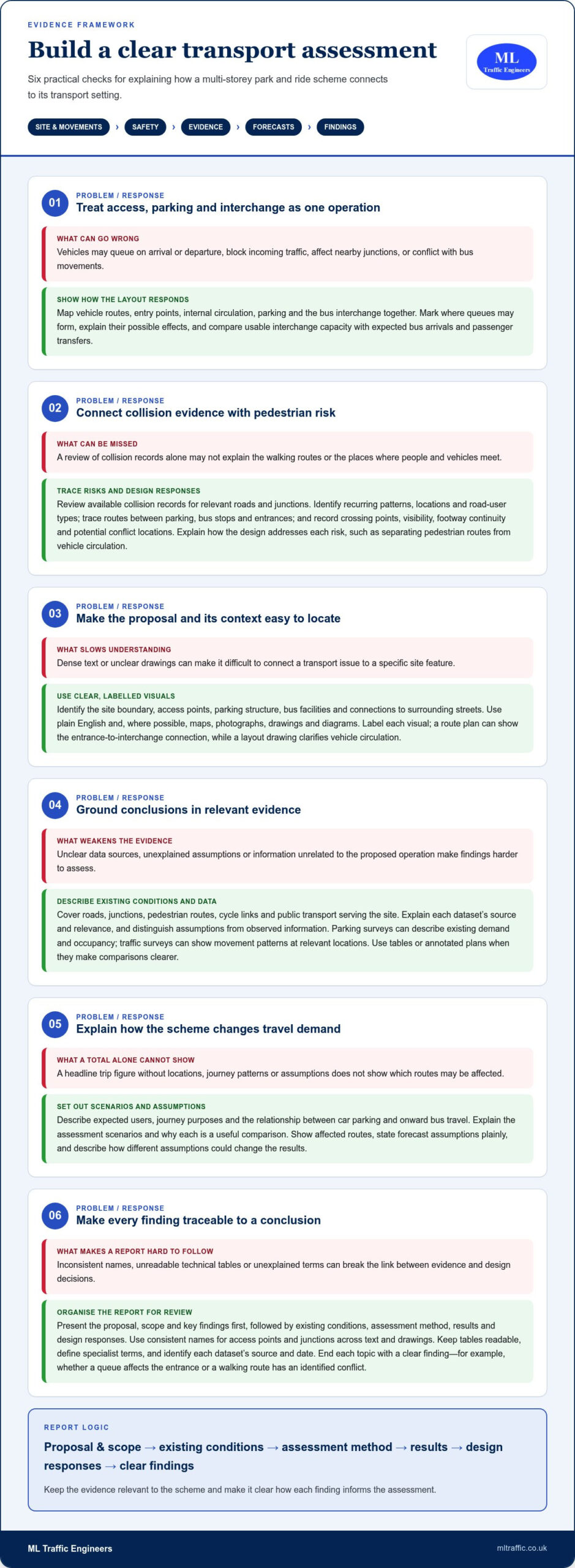
  • How to Calculate Trip Generation: A UK Development Guide

    How to Calculate Trip Generation: A UK Development Guide

    A trip-rate figure can look precise and still leave a planning submission exposed. Knowing how to calculate trip generation for a development means building a transparent evidence chain, from selecting comparable sites to explaining how the results translate into arrivals, departures and different travel modes.

    Choosing the right data means being clear about what a figure represents: people, vehicles or total movements. The answer depends on the development, the survey evidence and the assumptions behind the calculation. Multiplying a rate in isolation won’t show whether those choices are appropriate.

    This guide sets out a practical method for estimating trips, testing assumptions and presenting the results so another reader can reproduce the calculation. It explains how to assess comparable TRICS data, distinguish person trips from vehicle trips, and separate two-way totals from directional movements. It also shows how trip generation can inform a proportionate Transport Statement or Transport Assessment, helping you understand likely transport implications before submission.

    Key Takeaways

    • Learn how to calculate trip generation for a development by matching a suitable trip rate to the correct development size and assessment period.
    • Compare TRICS outputs, observed surveys and local evidence by land use, location, time period and denominator.
    • Keep a clear audit trail of data sources, units and assumptions so the calculation can be checked and reproduced.
    • Test how changes to key assumptions could affect the estimated trip total and explain why your chosen inputs are appropriate.
    • Understand how trip estimates can inform a proportionate Transport Statement or Transport Assessment, including access, travel modes and transport effects.

    What does trip generation mean for a development proposal?

    Trip generation estimates the movements associated with a particular land use over a defined period. For a development proposal, it describes how people may travel to and from the site and provides a starting point for considering potential transport effects. The Trip generation concept is also recognised as the first step in the traditional four-step transportation forecasting model.

    The estimate depends on the proposed use, its scale, the site’s location and access, and the period being assessed. A residential scheme, for example, may produce a different pattern of movements from a workplace or retail use. A calculated rate supports planning analysis; it does not guarantee the traffic that will occur, since actual travel depends on the site context and people’s choices.

    This lecture introduces trip generation and trip distribution in transport planning:

    What counts as a trip, and which figures should you report?

    State exactly what the estimate counts. A one-way vehicle movement is one journey in one direction across the defined site access point. An arrival followed later by a departure is two movements, not one round trip. Person trips count people travelling and may include walking, cycling, public transport and car travel. Because a vehicle may carry more than one person, vehicle and person totals are not interchangeable.

    Label every result with its unit and period. State whether it is hourly or daily, whether it covers a peak period, and whether it reports two-way movements or separate inbound and outbound movements. Without those details, figures can be misread or compared incorrectly.

    When should a development assess trip generation?

    Assessment scope should reflect the proposal’s scale, land use and potential transport effects. A smaller scheme with limited implications may need proportionate evidence, while a larger or more complex proposal may require fuller analysis. The local planning or highway authority can guide the appropriate level of evidence for the site and application.

    Trip estimates help explain how a proposal relates to access arrangements, travel modes and transport effects. They may form part of a Transport Statement or a more detailed Transport Assessment. For further context, see our Transport Assessment guidance for developers. The next step is to select evidence that matches the development and the movements being assessed.

    How to calculate trip generation using comparable evidence

    A defensible calculation follows a clear sequence: define the proposed development, identify relevant evidence, apply a rate to the matching development quantum, test the assumptions, then report the method and results. The core relationship is:

    Estimated trips = selected trip rate × matching development quantum

    The units must match. A rate expressed per dwelling applies to the number of dwellings; a rate per square metre of floor area applies to the corresponding floor area. Before multiplying, check whether the rate represents vehicle movements or person trips, and confirm its time period and direction. A mismatch can produce a precise-looking result without a sound basis.

    How do you select and use TRICS trip-rate evidence?

    Start by identifying TRICS land-use categories that reflect the proposal, then review the survey sites behind the results. Compare their development scale, location, accessibility, public-transport context and survey conditions with the proposed site. A database result is not automatically comparable just because its land-use label looks similar.

    For a reproducible analysis, record the TRICS version, filters, selected sites and any exclusions, including the reasons for excluding them. TRICS 8.26.2 was identified as the latest stable release in November 2025. Check the current database version and survey-selection guidance when preparing an assessment.

    How do you calculate arrivals, departures and total movements?

    Write down the rate, denominator, assessment period and development quantum before calculating. If the source provides separate inbound and outbound rates, apply each to the matching quantum and report the results separately. If it provides only a two-way rate, don’t present an assumed directional split as observed evidence. Explain the basis for any estimated split.

    Keep calculations unrounded until the final presentation, then state how you rounded and aggregated them. Report units clearly, such as movements per hour or movements per day, and avoid implying greater certainty than the survey evidence supports.

    • Define: land use, scale and assessment period.
    • Select: comparable evidence and document exclusions.
    • Calculate: apply the rate to its matching quantum.
    • Test and report: explain assumptions, units and rounding.

    Trip estimates can form part of the evidence in a proportionate Transport Statement or Transport Assessment. The official government guidance sets out the role of these planning documents. To calculate trip generation for a development, keep the working traceable from source data to reported totals, so the assumptions can be reviewed alongside the wider transport evidence.

    Where a proposal needs project-specific analysis, trip-generation evidence can be considered within a Transport Assessment for a planning application.

    How should you compare trip-rate data and account for site context?

    A trip rate is useful only when its source reflects the proposal closely enough to support comparison. TRICS outputs, observed traffic surveys and local evidence can each inform an assessment, but they measure different things and should not be treated as interchangeable. Check what each source counts, how it was collected and whether its conditions match the site and assessment period.

    A nearby development isn’t automatically a good comparator. Its land use, scale, access arrangements, public-transport options or surrounding uses may produce a different travel pattern. Record why you selected or excluded evidence rather than relying on proximity alone.

    Evidence source Compare Key limitations to record
    TRICS output Land-use category, site geography, survey period and rate denominator Selection filters, chosen sites and differences from the proposed development
    Observed survey Site function, access, day type, peak period and movements counted Survey date, unusual conditions and whether the period represents typical activity
    Local evidence Relevance to the proposal, location, land use and measurement units Source, collection method, coverage and any assumptions used to apply it

    Which factors make a comparable survey site credible?

    Check whether the comparator has a similar land-use function, scale, occupancy or operating pattern. Then consider the local context, including access to public transport, nearby homes and services, and how people can reach the site. Review the survey date, season, day type and peak period. If conditions were unusual or the match is imperfect, state the limitation and explain why it matters.

    Keep mode share separate from vehicle trip rates. A vehicle rate does not describe all journeys made by walking, cycling or public transport. Don’t apply a mode-share adjustment simply because a site appears accessible. Use project-specific evidence or a clear, justified method.

    When should you adjust gross trips to estimate net change?

    Where a site has an existing lawful use, first establish whether its trips are supported by evidence and relevant to the same assessment period. Show the proposed development’s gross trips, then any existing-use deduction as a separate step. Explain the evidence and calculation for each. Treat pass-by, diverted and linked trips cautiously, and include an adjustment only when the method and supporting evidence justify it.

    These comparisons make how to calculate trip generation for a development transparent and defensible. They also support a proportionate Transport Statement or Transport Assessment, as outlined in official government guidance. For London planning context, see the London transport assessment guide. Project-specific Transport Assessment support can bring evidence and assumptions together in a clear planning submission. See ML Traffic Engineers UK transport planning information.

    How to Calculate Trip Generation: A UK Development Guide

    How do you test assumptions and present a robust calculation?

    A calculation is useful only if another reviewer can follow how you reached it. Keep a clear audit trail from the development inputs to the reported trip totals, and state where evidence is limited. This makes it easier to consider the estimate alongside access arrangements, sustainable travel options and the likely effects on the surrounding highway network.

    What should a sensitivity check include?

    Identify assumptions that could materially influence the result, such as development quantum, occupancy or the selected trip rate. Test a reasonable alternative only when its basis is stated and supportable. For example, compare the chosen rate with another relevant evidence-based rate and explain why it provides a credible alternative. Report how each scenario affects the total and whether it changes the assessment’s conclusions. There is no universal sensitivity threshold to apply.

    What should the calculation report show?

    Include enough information to reproduce the calculation and understand its limits. A practical checklist is:

    • Proposal: land use, scale and development quantum.
    • Evidence: source, selected rate and reasons for its use.
    • Definitions: calculation unit, movement type and assessment period.
    • Working: formula, inputs, directional totals and any gross-to-net steps.
    • Qualifications: assumptions, limitations, rounding and matters that may need agreement with the relevant planning or highway authority.

    Keep arrivals and departures visible where the evidence supports a directional split. Show gross proposed trips separately from any deduction for an existing use, and explain the basis for each figure. Round consistently, but don’t present a modelled estimate as a precise prediction of future traffic.

    Use the results to frame the transport questions that follow. Consider whether access arrangements can accommodate the movements, how walking, cycling and public transport relate to the proposal, and whether further analysis of highway effects is warranted. This makes trip-generation calculations part of a proportionate planning assessment rather than an isolated number.

    For related planning context, read the Transport Statement for a planning application. If your project needs its assumptions and evidence brought together for submission, discuss your trip-generation analysis with ML Traffic Engineers.

    How trip generation informs a Transport Statement or Transport Assessment

    A trip-generation estimate gives a planning submission a starting point for describing the movements a development may produce. Within a Transport Statement or Transport Assessment, it helps explain how the proposal relates to site access, travel by different modes and potential effects on the surrounding transport network. The estimate should support the wider evidence, not stand alone as a prediction of exactly what will happen.

    The appropriate level of detail depends on the development’s scale, land use, location and likely transport effects, as well as the planning and highway authority context. A smaller proposal may need a concise, proportionate account; a more complex scheme may call for fuller analysis. Neither report type nor calculation method is automatically necessary for every application. Consider the relevant authority’s requirements and the project’s circumstances.

    Trip generation also helps frame practical questions: can the proposed access accommodate expected movements, what proportion may use sustainable modes, and where could further assessment of transport effects be needed? Clear assumptions make these connections easier to review.

    When is project-specific transport analysis valuable?

    Project-specific analysis is useful when a site’s context differs from standard comparators, key inputs remain uncertain or authority feedback raises questions about the evidence. Traffic surveys can help test assumptions about existing conditions or local movement patterns where appropriate. Select and interpret surveys for the question being assessed, rather than treating them as a substitute for development trip-rate evidence.

    This scrutiny strengthens the link between calculating trip generation for a development and the planning decisions the calculation is intended to inform. ML Traffic Engineers prepares Transport Statements and Transport Assessments for planning applications, using traffic surveys and technical analysis where relevant. Explore development transport planning projects for related project context.

    What are the next steps for a developer?

    Bring the core project information together before settling the assessment scope. This gives the trip-generation analysis a clear basis and helps identify gaps early.

    • Site: location, proposed land use and development quantum.
    • Access: existing and proposed access arrangements.
    • Evidence: available surveys, transport data and assumptions already used.
    • Planning context: relevant discussions or feedback from the local planning or highway authority.

    With these details in hand, the estimate can be considered alongside the wider transport evidence and tailored to the proposal. To discuss project-specific analysis for your development, discuss transport planning support for your development with ML Traffic Engineers.

    Build a trip estimate your planning submission can stand behind

    A credible trip-generation calculation is more than a rate multiplied by a development size. It depends on comparable evidence, matched units and assessment periods, and assumptions that are clearly stated and tested. Keep the result reproducible, distinguish vehicle movements from person trips, and present uncertainty honestly.

    Use the estimate as part of the wider transport case. Its role is to explain how the development relates to site access, travel choices and potential transport effects, with the level of assessment proportionate to the proposal and its planning context. Understanding how to calculate trip generation for a development gives you a firmer basis for that evidence, while project-specific analysis can help address site conditions or inputs that need closer review.

    ML Traffic Engineers prepares Transport Statements and Transport Assessments for planning applications. Traffic surveys and technical analysis can support evidence tailored to the project. Discuss transport planning support for your development and take the next step with a clearer evidence base.

    With transparent assumptions and relevant transport evidence, you can move your proposal forward with greater confidence.

    Frequently Asked Questions

    How do you calculate trip generation for a development?

    Multiply a suitable trip rate by the matching development quantum, then check that the rate’s units, denominator and assessment period fit the proposal. For example, apply a rate per dwelling to the number of dwellings, not the floor area. Record the evidence source and explain any assumptions. Where the data supports it, report arrivals and departures separately, and test how reasonable changes to key inputs affect the estimate.

    What is a trip rate in development planning?

    A trip rate expresses the number of movements associated with a defined land use and unit of development over a stated period. It might be reported per dwelling, per floor area or another relevant measure. Check whether it refers to vehicle movements or person trips, and whether it covers an hour, a day or a peak period. The rate’s definition determines how it can be used in a calculation.

    Can I use TRICS to calculate trips for any development?

    TRICS can provide trip-rate evidence when its recorded land-use and survey data are relevant to the proposal, but it won’t automatically provide a suitable comparator for every development. Assess selected sites for function, scale, location, access, travel context and survey period. Document the database version, filters and exclusions, and explain any limitations. If available TRICS evidence is a poor fit, use other justified evidence rather than forcing an unsuitable comparison.

    How do I calculate vehicle trips from person trips?

    You can’t reliably convert person trips into vehicle trips without evidence about travel mode and, for car travel, vehicle occupancy. First establish how many person trips are made by each mode, then apply a supported mode-share assumption and occupancy factor to estimate vehicle movements. Keep those inputs visible and relevant to the project. Don’t treat person trips and vehicle trips as equivalent or assume every person travelling by car creates a separate vehicle.

    Should existing site trips be deducted from development trip generation?

    Deduct existing trips only when the site has an existing lawful use and its trip generation is supported by relevant evidence. Check that the existing-use figures relate to a comparable time period and movement type. Present the proposed development’s gross trips first, then show the existing-use deduction separately to calculate net change. Explain the evidence and assumptions behind both stages so reviewers can follow how the net estimate was derived.

    What is the difference between gross and net trip generation?

    Gross trip generation is the estimated movement total for the proposed development before deducting trips associated with an existing use. Net trip generation is the resulting change after any justified existing-use trips are subtracted. For example, a redevelopment may have fewer net trips than gross trips if a previous lawful use generated movements. Report both figures and show the calculation rather than presenting a net total without its supporting steps.

    Does every development need a Transport Assessment to calculate trip generation?

    No. The appropriate transport evidence depends on the proposal’s scale, land use, location and likely transport effects, as well as the planning and highway authority context. A proportionate Transport Statement may suit some schemes; others may need a fuller Transport Assessment. Requirements can vary by project and authority. This applies to developments across Greater London, Manchester, Birmingham, the West Midlands, Liverpool and southern counties, including Surrey, East Sussex, West Sussex, Hampshire, Berkshire and Buckinghamshire.

    Michael Lee

    Article by

    Michael Lee

    Transport planner with over 35 years' experience.

    Disclaimer

    The content on mltraffic.co.uk, including all technical articles, guides, and resources, is provided for general informational and educational purposes only. It is not intended to constitute professional advice in traffic engineering, transportation planning, development approvals, or any other technical or legal field.
    While ML Traffic Engineers makes every reasonable effort to ensure the accuracy, completeness, and timeliness of the information published, we do not provide any warranties or representations (express or implied) regarding its reliability, suitability, or availability for any particular purpose. Any reliance you place on the content is strictly at your own risk.
    In no event shall ML Traffic Engineers, its directors, employees, authors, or affiliates be liable for any direct, indirect, incidental, special, consequential, or punitive damages (including, without limitation, loss of profits, data, or business opportunities) arising out of or in connection with the use of, or inability to use, any information provided on this website.
    The articles and guides on this site are not a substitute for engaging a qualified, professional traffic engineer to assess your specific project requirements. For tailored advice, compliance assessments, or traffic engineering services, please contact a competent professional.
    This disclaimer may be updated from time to time without notice. By accessing or using this website, you agree to be bound by the most current version of this disclaimer.

  • Redbridge Sports Facility Transport Assessment Guide

    Redbridge Sports Facility Transport Assessment Guide

    A busy match or tournament can put very different demands on local roads, parking and public transport than an ordinary weekday. For a transport assessment for sports facility in Redbridge, the key is to show how event-day peaks relate to the site’s access and the surrounding transport network.

    It can be difficult to know whether a Transport Statement or a full Transport Assessment is appropriate, which surveys to commission, and what Redbridge planners will expect. The right scope depends on the proposal and its likely transport effects, so deciding too early can leave important questions unanswered.

    This guide explains what to consider before commissioning work and how to prepare a site-specific evidence base. It covers event and user travel patterns, vehicle access, parking, and walking, cycling and public transport connections, as well as the local policy context. It also outlines what to ask a consultant about scope, survey methods and report contents. Agreeing requirements for the specific proposal helps ensure the report addresses relevant planning questions.

    Key Takeaways

    • For a transport assessment for sports facility in Redbridge, agree the scope against the proposal’s likely transport effects and the relevant authority’s requirements.
    • Compare typical operating conditions with busy sessions, competitions and other event peaks when identifying potential transport impacts.
    • Check which current Redbridge planning requirements and London-wide guidance apply before deciding what evidence to prepare.
    • When appointing a consultant, clarify relevant experience, proposed surveys and analysis, and exactly what the report will include.
    • Coordinate assumptions and drawings across the client, architect, planning agent and transport consultant to keep the assessment consistent.

    When does a sports facility in Redbridge need a transport assessment?

    A Transport Assessment (TA) provides evidence about how a proposed development could affect transport and how people are expected to travel to and from it. Its scope should reflect the proposal and the planning authority’s requirements. For a sports venue, that means considering not only the building, but also the activity it is expected to generate and when it will take place.

    A Transport Statement (TS) generally gives a more concise, proportionate account where transport effects are more limited. There is no single facility-size rule that determines the right document in every case. Check Redbridge’s requirements for the specific application, including whether the planning or highway authority expects a TA, a TS or other supporting evidence. The broader transportation planning process helps explain why evidence should connect proposed activity with the transport network.

    A sports-facility proposal may need transport evidence when its expected travel demand or access arrangements could affect the surrounding network. Confirm the appropriate report and scope in the planning context.

    Which sports-facility proposals may prompt transport scrutiny?

    Consider what is changing, not just the venue’s floor area. A new sports centre, an extension to an existing club, upgraded pitches, a change of use or an increase in activity can each raise different transport questions. For operators also managing facility upkeep or pitch installations during venue redevelopments, learn more about professional equipment inspections and surfacing maintenance. A facility with regular classes may create steady arrival and departure patterns. A venue hosting occasional competitions may have sharper peaks and a different visitor profile.

    Capacity, opening hours, event frequency, and the balance between participants, spectators and staff can all affect the evidence needed. The local planning authority determines its requirements in light of the proposal, site and planning context. Do not assume an existing use or a modest building means transport effects are automatically limited.

    What should a Redbridge project team clarify first?

    Before commissioning a transport assessment for sports facility in Redbridge, assemble the site address, proposed use, expected capacity, operating hours and planning status. Note planned changes to event frequency or visitor numbers, and identify what is known about access and parking. These details help a consultant assess the likely scope rather than relying on a generic brief.

    Ask whether pre-application advice or a discussion with a planning officer is appropriate, and confirm current local requirements before agreeing the assessment methodology. For wider context on transport evidence for London planning applications, see the Transport Assessment London guide. ML Traffic Engineers UK prepares project-specific Transport Assessments and Transport Statements, with supporting evidence considered where required.

    What should a transport assessment for sports facility in Redbridge examine?

    A clear report follows a logical chain: describe the proposal, establish existing transport conditions, forecast travel demand, assess impacts and identify proportionate mitigation where needed. For a transport assessment for sports facility in Redbridge, that chain should reflect how the venue will operate, rather than treating every day as a typical weekday.

    Set out the site and proposed use, then describe relevant access and travel options. Evidence may cover walking, cycling, public transport and road conditions, alongside vehicle access and parking. The assessment should explain the basis for its forecasts and how the proposal could affect the transport network. The official government guidance is a starting point, but check survey methods and data requirements against the project and confirm them with the relevant authority.

    A sports venue’s busiest transport period may be driven by session changeovers or event schedules, not the conventional weekday peak. Assess ordinary operating periods separately from busy classes, competitions or special events, when arrivals and departures may overlap or concentrate.

    How should event-day travel demand be described?

    Make attendance assumptions clear. Explain expected numbers of participants, staff, teams and spectators, along with session turnover, event schedules and any information that remains unconfirmed. Where timings could affect nearby streets or public transport, show arrival and departure profiles separately instead of relying on a single daily total.

    For example, a competition where spectators arrive before a session ends may create a different pattern from classes with staggered start times. Identify which figures come from the client and which are estimates, so the project team can verify them before they inform the assessment.

    Which access, parking, and movement questions matter?

    Test how people can reach the facility on foot, by cycle and by public transport, as well as by car. Consider vehicle access, servicing, accessible arrival arrangements and how parking supply compares with expected demand. Check the local parking requirements that apply rather than assuming a generic standard fits the site.

    Use surveys or trip-generation methods where they are relevant to the proposal and agreed scope. If vehicle manoeuvring or access geometry needs to be demonstrated, swept path analysis can test whether relevant vehicles can move through the proposed layout. ML Traffic Engineers also prepares traffic surveys and parking surveys where appropriate to the evidence brief. See ML Traffic Engineers’ transport planning services for project-specific assessment support.

    How do Redbridge policy and local transport conditions shape the evidence?

    A transport assessment should respond to both the proposal and the policies and validation requirements that apply to its site. Redbridge’s Local Plan covers 2015-2030, while the London Plan 2021 provides a strategic London-wide framework. Before relying on either, check the council’s current planning pages for adopted updates, relevant policies and application validation requirements. A policy reference alone does not establish what evidence a particular sports-facility proposal needs.

    Review the council’s Redbridge local transport policy, including its Local Implementation Plan, and confirm whether other borough transport strategies are relevant. Establish which authority is responsible for roads or transport facilities affected by the proposal. Depending on the location and scope, confirm whether Transport for London (TfL) or another highway authority has a role. Check current Department for Transport guidance and any applicable TfL guidance before agreeing survey methods or report scope.

    Which local sources should the project team verify?

    Use current, authoritative documents rather than copied thresholds or assumptions from another site. Check Redbridge Council’s planning and local application requirements, applicable Local Plan policies, the London Plan and relevant national guidance. Where documents do not settle a question, confirm requirements with the planning or highway officer. Distinguish confirmed policy and validation requirements from points that still need officer advice.

    How should local access and travel conditions be evidenced?

    Describe the site’s actual connections: access points and surrounding streets, walking and cycling routes, public transport options, and relevant parking conditions. Use current, appropriately scoped evidence, and record its sources and dates. Include Public Transport Accessibility Level (PTAL) information only if it helps explain accessibility for this proposal, and identify its source and assessment date. Do not describe a road as congested or parking as under pressure without supporting evidence.

    The table below helps the project team track what is known and what still needs confirmation for a transport assessment for sports facility in Redbridge.

    Transport question Evidence to check Source and verification status
    Which planning requirements apply? Relevant policies and validation documents Redbridge Council; confirm against the live proposal
    Who is the relevant highway authority? Road responsibility and any TfL involvement Confirm for the site and affected routes
    How accessible is the site? Walking, cycling, public transport and, if relevant, PTAL Use current sources; record dates and applicability
    What local transport effects need evidence? Access, parking and network conditions Use suitable project evidence; agree unresolved matters with officers

    This approach keeps the report focused: cite confirmed requirements and clearly label assumptions or points awaiting authority advice.

    Redbridge Sports Facility Transport Assessment Guide

    How can you choose the right transport assessment consultant?

    Choose a consultant who can explain how the report will answer planning questions for your venue, not simply provide a standard document. For a transport assessment for sports facility in Redbridge, ask how the approach will account for event peaks, site access, parking and travel alternatives, and how it will reflect current authority requirements.

    Use this shortlist to compare potential consultants:

    1. Define the scope. Ask which planning questions the assessment will address and whether the proposal calls for a Transport Assessment or Transport Statement.
    2. Test relevant experience. Ask about comparable projects and how the consultant has considered sports-facility schedules, attendance patterns and local planning contexts.
    3. Agree the evidence. Confirm which existing information can be used, whether traffic surveys, parking surveys or swept path analysis are justified, and who will arrange any required data collection.
    4. Confirm deliverables and coordination. Agree report contents, assumptions, review stages, responsibilities and how the consultant will coordinate with the client, architect and planning agent.

    What should a sports-facility consultant brief include?

    Provide the site plan and address, proposed uses, capacity, opening hours, event calendar and known access constraints. Share available parking, travel, survey and operational information with its source and date, so the consultant can assess whether it remains suitable. Include the planning timetable, application status and any feedback already received from the planning or highway authority.

    Flag provisional information. If event attendance or session times are not confirmed, ask the consultant to record those assumptions and explain how they affect the evidence and conclusions.

    How can you compare scope and technical approach?

    Compare proposals by what each report will cover, which evidence sources it will use, and how it will handle uncertainty and planning coordination. A survey or technical analysis should have a clear purpose tied to the site, rather than appear as an unexplained default. Ask how findings will be reviewed and shared with the wider design team before submission.

    For broader context, consult ML Traffic Engineers’ Transport Assessment London guide. The company’s What We Do page also sets out its transport planning services, including Transport Assessments, Transport Statements, surveys and swept path analysis.

    Once you have prepared a project brief, review ML Traffic Engineers’ services to see how its transport planning work may fit your proposal.

    What happens after commissioning a Redbridge transport assessment?

    Once the brief is agreed, the work should move through clear stages: confirm the scope, check project information, gather or review relevant evidence, assess the proposal and prepare the report for review. For a transport assessment for sports facility in Redbridge, keep design and operating assumptions consistent. A change to access, capacity or event timings may affect the analysis, so the transport consultant needs the latest information as the scheme develops.

    What information and decisions keep the work moving?

    At the start, confirm the current site layout, access design, proposed capacity, operating schedule and planning proposals. The client should nominate a contact who can answer operational questions, verify attendance or event assumptions and provide missing information. Agree who will arrange site or survey access, when any data collection should take place and how drawing revisions will be issued.

    Coordination matters. The architect should share current drawings, the planning agent should flag application requirements and authority feedback, and the client should confirm how the facility will operate. Set review responsibilities and timings in advance. If the layout changes during the assessment, the team can identify whether the evidence or conclusions need updating before the report is finalised.

    What should the completed report enable?

    The finished report should provide a traceable account of the proposal, evidence considered, assessment undertaken and resulting conclusions. It should make clear which inputs are verified, which are assumptions, and how the findings relate to the proposed development. This gives the planning team a coherent document to submit and helps the relevant authority understand the transport matters considered.

    Submission does not guarantee planning approval. The authority may ask for clarification, further information or revisions, depending on its review of the application and evidence. If questions arise, the planning agent, client and transport consultant should coordinate responses and ensure revised drawings or assumptions remain aligned with the report.

    Before delivery, check that the report references the correct scheme version and that the client has confirmed key operational details. A final consistency check can help prevent queries caused by outdated plans or conflicting assumptions.

    For an overview of the company’s services, visit ML Traffic Engineers.

    Set your Redbridge transport evidence on a clear path

    A well-scoped assessment connects the facility’s operating pattern, including busy sessions and events, to transport evidence relevant to its site. Confirm whether a Transport Assessment or Transport Statement is appropriate, check current Redbridge and London requirements, and agree assumptions, surveys and report scope before work begins. Coordination between the client, design team and transport consultant helps keep the evidence aligned with the evolving proposal.

    ML Traffic Engineers provides transport planning services, including Transport Assessments, Transport Statements, traffic and parking surveys, and swept path analysis. The consultancy supports projects across Greater London, Manchester, Birmingham, the West Midlands, Liverpool, Surrey, East Sussex, West Sussex, Hampshire, Berkshire and Buckinghamshire. The appropriate evidence depends on the project, and the authority makes its own assessment of the application.

    If you’re ready to clarify the scope for a transport assessment for sports facility in Redbridge, contact ML Traffic Engineers to discuss your proposal and the supporting evidence that may be appropriate.

    Frequently Asked Questions

    Does a sports facility in Redbridge need a Transport Assessment?

    Possibly. A transport assessment for sports facility in Redbridge may be requested when a proposal could affect travel patterns, site access or the surrounding transport network. The appropriate evidence depends on the development, its operation and the local planning context, not just the building’s size. Check Redbridge Council’s current application requirements and seek planning or highway authority advice if the scope is unclear before commissioning a report.

    What should a sports-facility transport assessment include?

    It should explain the proposal, describe relevant existing transport conditions, forecast development-related travel demand, assess potential effects and present proportionate conclusions or mitigation. For a sports venue, the evidence may need to distinguish routine operation from classes, competitions or other busy periods. It can consider access by car, public transport, walking and cycling, as well as parking. The final scope and evidence should suit the site and confirmed authority requirements.

    How are event-day traffic peaks assessed for a sports facility?

    Start with clear assumptions about attendance, event schedules, session changeovers, staff, teams and spectators. The assessment can compare ordinary operating patterns with event-day arrivals and departures, especially where timings may concentrate trips on local streets or public transport. Traffic or parking surveys may help establish existing conditions if justified for the project. Record the source and date of inputs, and confirm provisional attendance or scheduling details with the facility operator.

    Is a Transport Assessment different from a Transport Statement?

    Yes. Both provide transport evidence for planning, but a Transport Assessment typically examines effects in greater depth, while a Transport Statement is generally more concise and proportionate where transport effects are more limited. There is no single facility-size rule that determines which applies in every case. The development proposal, likely effects and planning authority’s requirements should guide the choice. Confirm the expected report type and scope for the specific Redbridge application.

    Will Redbridge Council require traffic or parking surveys?

    Not automatically for every sports-facility proposal. Redbridge Council may require or seek survey evidence depending on the site, the proposal and the transport questions that need answering. Traffic or parking surveys can help establish existing conditions, but their location, timing and scope should suit the assessment and be checked against current application requirements or authority advice. Ask the consultant to explain why each survey is proposed and what decision it will inform.

    Can a sports facility transport assessment address walking and public transport?

    Yes. A transport assessment can examine how people could reach the facility by walking, cycling and public transport, alongside vehicle access and parking. It should describe relevant routes and connections using current, appropriately sourced information, and consider whether the proposal’s operating hours or event schedule affect those options. Accessibility measures such as PTAL should only be included where relevant, with the source and date stated, rather than treated as a substitute for site-specific analysis.

    When should I appoint a transport planning consultant for a Redbridge sports facility?

    Appoint a consultant early enough to clarify the report scope before the planning submission and while site access and layout can still be reviewed. Share the site plan, proposed use, capacity, hours, event information, planning status and any authority feedback. The consultant can then advise whether a Transport Assessment or Transport Statement is appropriate and whether surveys or swept path analysis are justified. ML Traffic Engineers prepares transport reports and supporting technical evidence.

    Michael Lee

    Article by

    Michael Lee

    Transport planner with over 35 years' experience.

    Disclaimer

    The content on mltraffic.co.uk, including all technical articles, guides, and resources, is provided for general informational and educational purposes only. It is not intended to constitute professional advice in traffic engineering, transportation planning, development approvals, or any other technical or legal field.
    While ML Traffic Engineers makes every reasonable effort to ensure the accuracy, completeness, and timeliness of the information published, we do not provide any warranties or representations (express or implied) regarding its reliability, suitability, or availability for any particular purpose. Any reliance you place on the content is strictly at your own risk.
    In no event shall ML Traffic Engineers, its directors, employees, authors, or affiliates be liable for any direct, indirect, incidental, special, consequential, or punitive damages (including, without limitation, loss of profits, data, or business opportunities) arising out of or in connection with the use of, or inability to use, any information provided on this website.
    The articles and guides on this site are not a substitute for engaging a qualified, professional traffic engineer to assess your specific project requirements. For tailored advice, compliance assessments, or traffic engineering services, please contact a competent professional.
    This disclaimer may be updated from time to time without notice. By accessing or using this website, you agree to be bound by the most current version of this disclaimer.