Tag: TRICS

  • Public Bar Transport Assessment

    Public Bar Transport Assessment

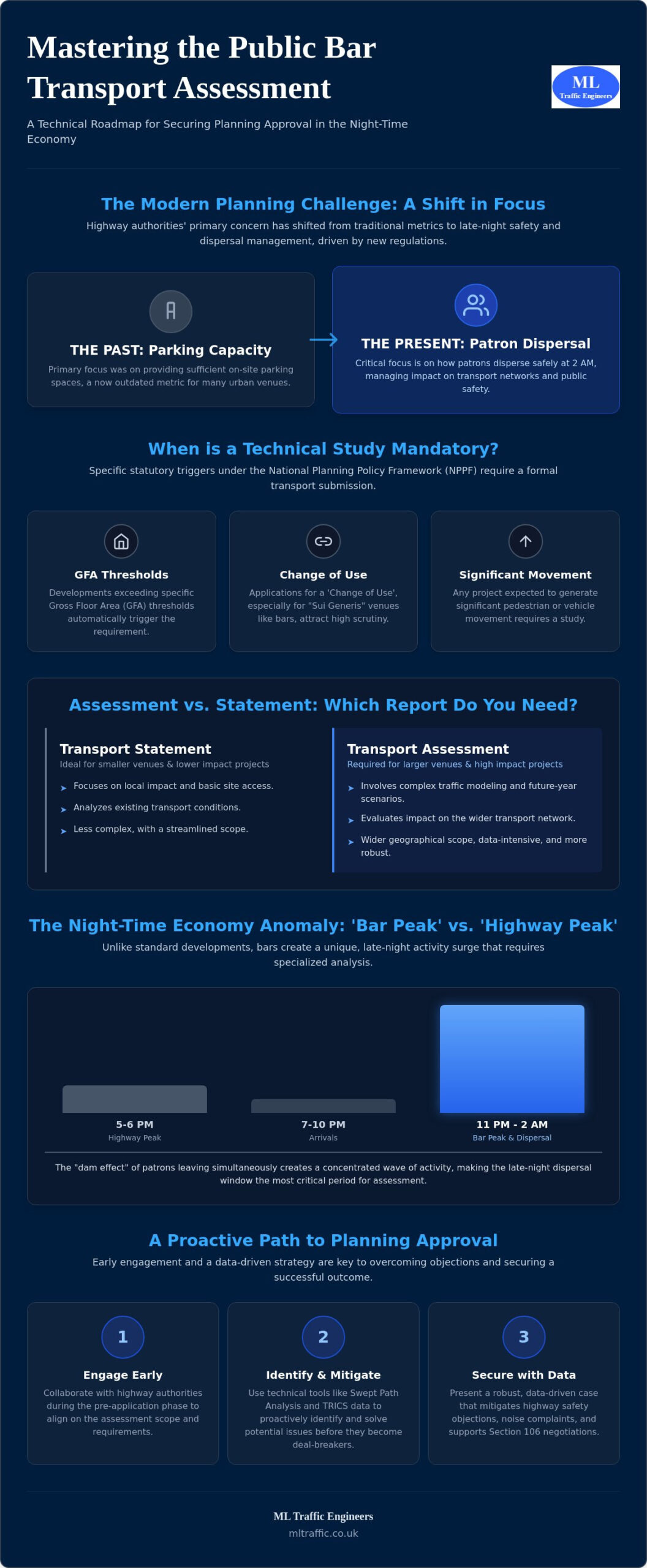
    What if the primary barrier to your venue’s planning approval isn’t the number of parking spaces, but how efficiently your patrons disperse at 2 AM? You’ve likely faced the frustration of highway authority objections or felt overwhelmed by the technical requirements of a public bar transport assessment. Navigating the shift from traditional parking requirements to modern night-time safety standards can feel like a moving target. This is especially true with recent regulatory shifts, such as the January 2025 TfL Night-time Active Travel Zone requirements and the security mandates associated with Martyn’s Law.

    We understand that securing a license requires more than just a floor plan; it demands technical authority and a proactive approach to highway safety. This article provides a clear roadmap to mastering these complexities, ensuring you secure planning approval with precision while reducing the risk of costly delays. You’ll learn how to leverage accurate data to negotiate Section 106 requirements and determine whether your project needs a full Assessment or a streamlined Transport Statement.

    Key Takeaways

    • Identify the statutory triggers, including Gross Floor Area thresholds and change-of-use requirements, that necessitate a formal technical study for your venue.
    • Analyze the unique travel patterns of the night-time economy to understand why late-night dispersal data carries more weight than traditional peak hour traffic.
    • Master the technical requirements of a public bar transport assessment, including using the TRICS database and Swept Path Analysis to verify site access.
    • Discover how transport-led dispersal strategies can proactively mitigate highway safety objections and noise complaints from local authorities.
    • Learn how to navigate the full planning lifecycle to secure approval and negotiate Section 106 requirements with technical precision.

    What is a Public Bar Transport Assessment and When is it Mandatory?

    A public bar transport assessment serves as a vital technical document that evaluates how a proposed venue interacts with the surrounding transport infrastructure. It isn’t a mere formality; it’s a data-driven study of patron arrivals, staff travel patterns, and service vehicle access. Under the National Planning Policy Framework (NPPF), which received a significant update in December 2024, any development that generates significant movement must be supported by a robust transport submission. This ensures that the growth of The Night-Time Economy doesn’t compromise public safety or local road capacity.

    Statutory triggers for these assessments usually involve a change-of-use application or developments exceeding specific Gross Floor Area (GFA) thresholds. Because bars often fall into “Sui Generis” planning classes, they attract higher levels of scrutiny than standard retail units. Planning authorities want to see exactly how you’ll manage the “dispersal peak” when hundreds of patrons leave simultaneously at closing time. Failure to provide this data often results in immediate objections from highway officers.

    To better understand the strategic role of these assessments in modern development, watch this technical overview:

    Transport Statement vs. Assessment: Which One Do You Need?

    The level of detail required depends on the scale of your project. Smaller venues usually submit a Transport Statement, which focuses on local impact and site access. Larger venues or those in sensitive urban areas require a full Transport Assessment. These assessments involve complex traffic modeling and a wider geographical scope. Local borough variations across England mean that what suffices in one district might be rejected in another, making local expertise a functional necessity for approval.

    The Pre-Application Phase: Engaging Highway Authorities Early

    Success in the planning process often starts long before the formal application. Engaging highway authorities during a pre-application phase allows us to scope the public bar transport assessment to match their specific requirements. This collaborative approach identifies critical issues, such as narrow footways or inadequate loading bays, before they become deal-breakers. By addressing these technical hurdles early, you reduce the risk of late-stage highway safety objections that can delay your opening and inflate project costs. We focus on securing a clear roadmap to approval through precise data and proactive communication.

    The Night-Time Economy: How Bar Travel Patterns Differ from Traditional Pubs

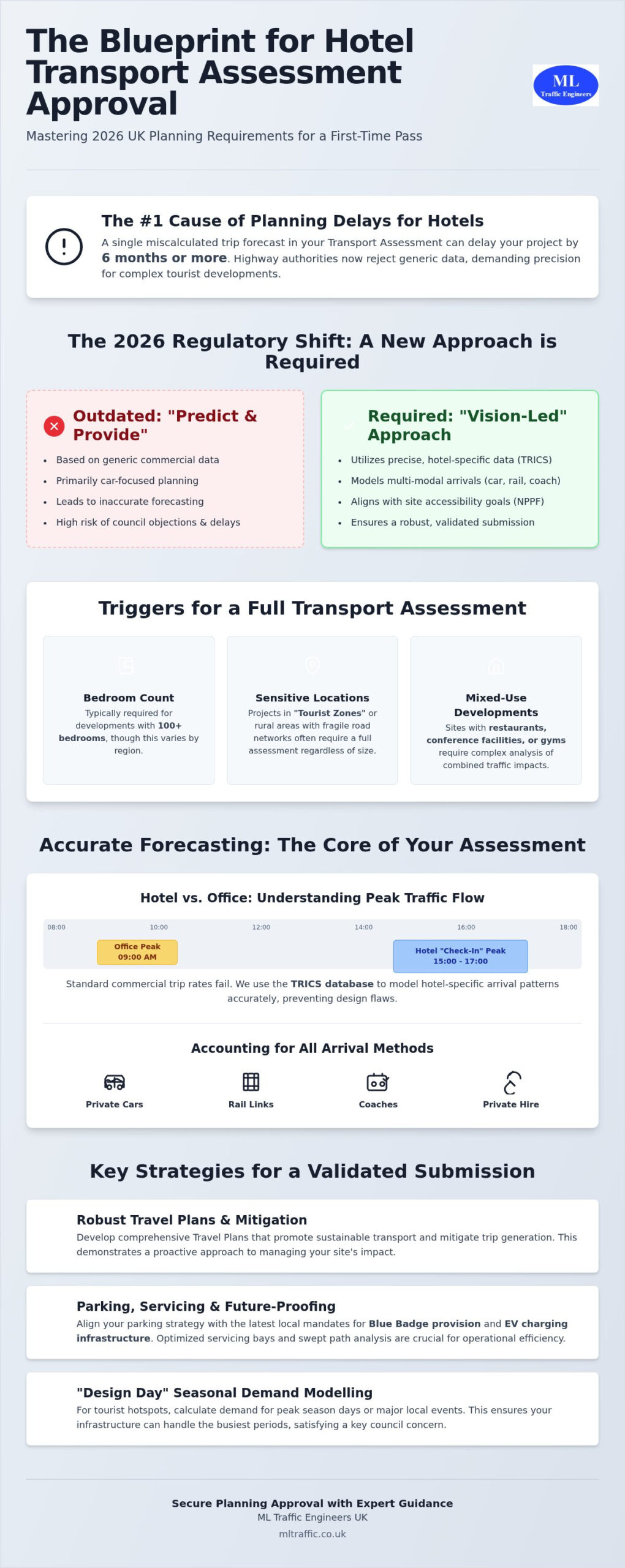
    Traditional pubs often see their highest activity during lunch hours or early evening “happy hours,” but modern bars operate on a completely different temporal scale. For a public bar transport assessment, the standard “Highway Peak” between 5 PM and 6 PM is frequently irrelevant. Instead, the “Bar Peak” typically occurs around 11 PM or later. This shift means that while the general road network is at its quietest, a single venue can create a localized surge in activity that requires specialized management. Local authorities now prioritize these late-night windows to ensure that the growth of the evening economy doesn’t lead to localized gridlock or safety hazards.

    The impact of the Night-Time Economy (NTE) on local transport infrastructure is profound. Unlike gastropubs, where turnover is dictated by meal service times, bars experience longer “dwell times.” Patrons tend to accumulate throughout the evening, leading to a “dam effect” where a large volume of people exits the venue in a concentrated wave at closing time. This creates a unique pressure on public transport and private hire networks that traditional traffic modeling often fails to capture. Understanding these nuances is why we recommend reviewing our technical resources to see how we model these specific late-night peaks.

    Current data shows a decisive shift away from private car use in urban centers. Modern patrons rely almost exclusively on public transport and ride-sharing platforms like Uber or Bolt. This transition changes the infrastructure requirement from “long-stay parking” to “high-frequency turnover.” National guidance on Transport Assessments and Statements highlights the need for developments to provide sustainable travel options, but for bars, this specifically means managing the “surge” of app-based pickups.

    Taxi and Private Hire Vehicle (PHV) Management

    Quantifying pick-up and drop-off (PUDO) demand is a critical component of a modern public bar transport assessment. We design safe “waiting zones” to prevent PHVs from double-parking on busy high streets, which is a common cause of highway authority objections. Proactive design ensures that patrons have a designated space to wait for their vehicles without obstructing the footway. As of 2026, data trends indicate that PHV arrivals now account for up to 65% of all non-pedestrian trips to urban late-night venues, necessitating dedicated PUDO infrastructure in every successful planning application.

    Pedestrian Flow and Dispersal Strategies

    Managing the sudden exit of patrons at closing time is essential for maintaining public order and safety. We evaluate pavement capacity to ensure it can accommodate both the dispersal of guests and any required queuing or smoking areas. This technical analysis must link directly to the venue’s Operational Management Plan (OMP). By aligning transport data with management strategies, we prove to planners that the venue can operate safely without causing noise complaints or pedestrian overcrowding.

    Essential Technical Elements of a Robust Bar Assessment

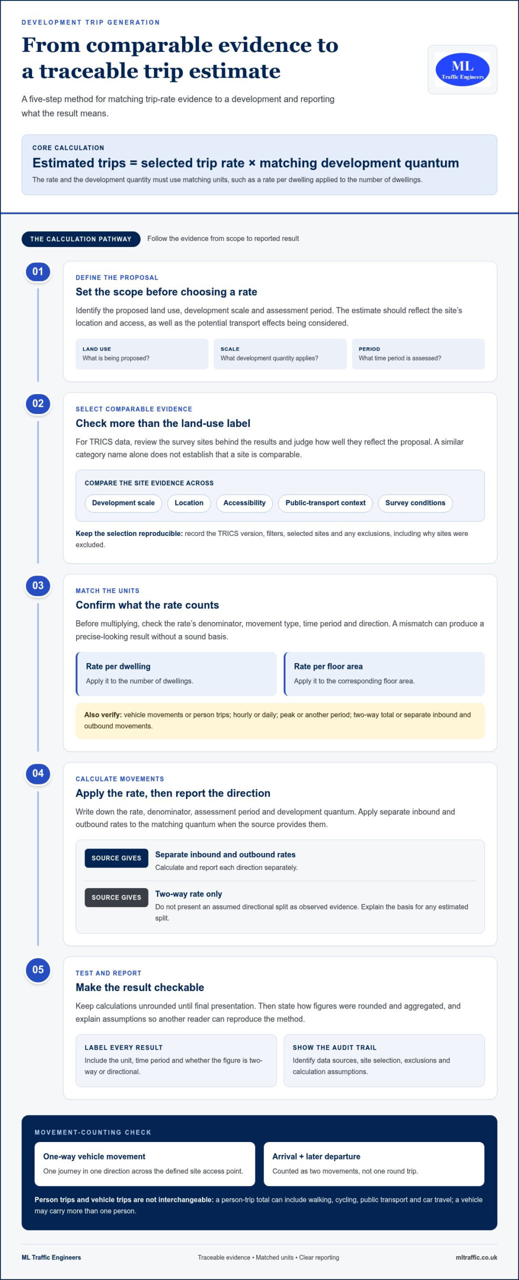
    A robust public bar transport assessment relies on verifiable data rather than assumptions. We begin by establishing trip generation figures using the TRICS database. This industry-standard tool allows us to forecast exact patron and staff movements by analyzing data from similar venues across the UK. We don’t just guess how many people will visit your venue; we select comparable sites with similar floor areas and urban contexts. This ensures the trip rates are defensible during planning committee hearings. We analyze hourly arrivals and departures, focusing on that critical late-night window when the local network is most sensitive to new noise and movement. These findings must align with the broader framework of Transport analysis guidance to ensure your application meets national technical standards.

    Collision data analysis is another non-negotiable element. Our team scrutinizes the last five years of Personal Injury Accident (PIA) data for the immediate highway network. We look for patterns involving alcohol-related incidents or late-night pedestrian collisions. If a pattern exists, we propose specific mitigation measures, such as improved street lighting or relocated pedestrian crossings. This proactive, safety-first approach reassures the council that you’re a responsible operator committed to public welfare. Proving that your venue won’t exacerbate existing safety issues is critical for overcoming highway authority objections.

    Swept Path Analysis for Servicing and Deliveries

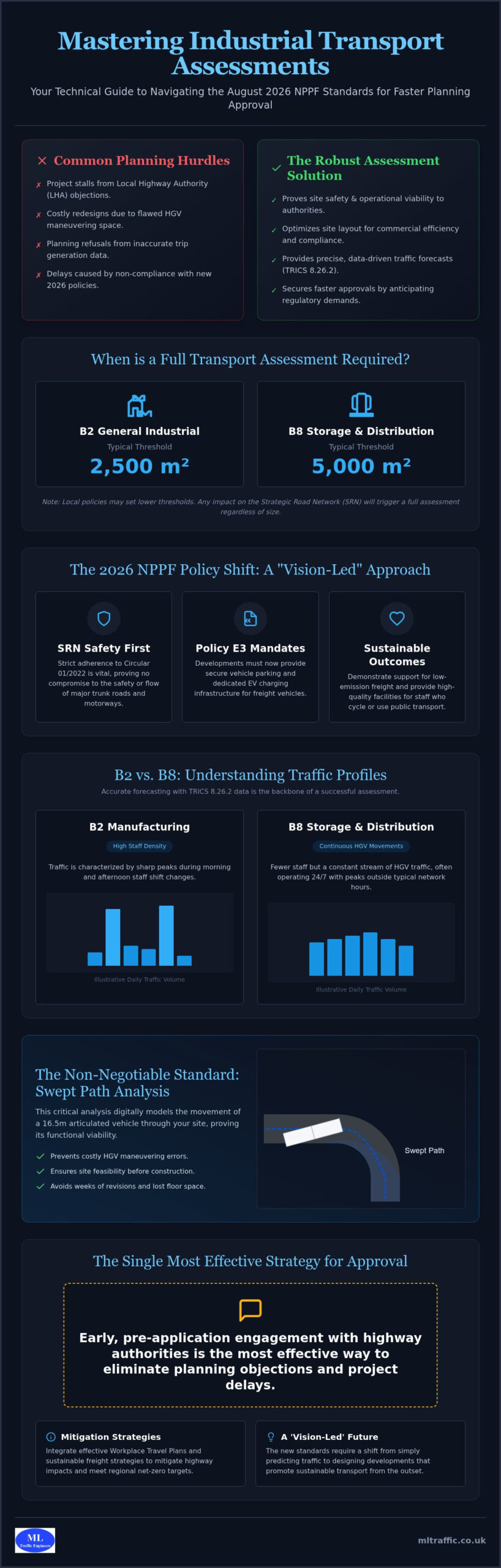
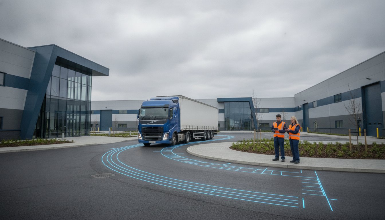
    Bars require frequent deliveries, often involving specialized vehicles like 10.7m dray wagons or standard refuse trucks. We use computer-aided design to perform Swept Path Analysis, which simulates vehicle movements on your site. This proves to planners that delivery bays are functional and don’t obstruct cycle lanes or pedestrian crossings. Precision here is vital; a single miscalculated turn in a narrow urban alleyway can lead to a planning refusal based on servicing concerns. We ensure your site layout accommodates these essential movements without compromising the safety of other road users.

    Parking and Accessibility (PTAL) justification

    In urban centers, justifying a car-free or low-parking development is standard practice. We utilize Public Transport Accessibility Level (PTAL) scores to demonstrate that your venue is well-served by trains, buses, and tubes. For areas where parking remains a concern, we conduct overnight parking surveys using the “Lambeth Methodology.” This technical approach measures current street capacity to prove that your patrons won’t over-burden local residents. Data-led parking surveys prevent the over-provision of car spaces in areas where sustainable travel is already the primary mode of transport. We ensure your application reflects the high accessibility of your location while maintaining local highway safety.

    Public Bar Transport Assessment

    Overcoming Common Planning Objections for Bar Developments

    Planning objections for new licensed premises often center on perceived risks to public safety or local amenity. A public bar transport assessment provides the technical evidence needed to dismantle these concerns. When authorities raise “Highway Safety” objections, we analyze visibility splays and pedestrian crossing capacity to prove the site remains safe under peak load. We don’t just state that the site is safe; we provide the geometric data and collision history analysis to confirm it. This level of precision is essential when negotiating with highway officers who prioritize risk mitigation above all else.

    Noise complaints are a frequent hurdle, but we address them through transport-led “Quiet Dispersal” routes. By identifying the most efficient paths to public transport hubs that bypass residential streets, we reduce the impact of patron noise on local residents. We also solve “Cumulative Impact” issues in established nightlife zones by demonstrating that the local infrastructure has the residual capacity to handle additional footfall. Our data proves that your venue won’t be the “tipping point” for local congestion. We also provide clear servicing schedules to ensure deliveries avoid peak traffic hours, keeping the local network fluid and reducing the risk of obstruction-based objections.

    Sustainable Travel and Travel Plans for Staff

    Securing planning consent often hinges on your commitment to sustainable travel. While patrons use ride-sharing, your late-night staff need reliable, safe ways to commute after hours. We develop robust Travel Plans that encourage the use of cycling or night-bus networks. Providing secure, well-lit cycle parking isn’t just a benefit for employees; it’s a functional requirement for many urban councils to reduce car dependency. If you need assistance with these documents, our Travel Plan Consultants can integrate these strategies into your broader application to strengthen your case.

    Negotiating Section 278 and Section 106 Agreements

    When a bar development requires physical highway improvements, such as new street lighting or upgraded paving, you’ll likely enter Section 278 or Section 106 negotiations. Our role at ML Traffic Engineers UK is to ensure “proportionality” in these developer contributions. We use the technical data from your public bar transport assessment to prevent you from overpaying for mitigation that exceeds your project’s actual impact. By providing an accurate baseline of existing traffic and pedestrian flow, we ensure your contributions remain fair and legally defensible. If you are facing complex highway requirements, contact ML Traffic Engineers UK today to review your site’s specific needs and ensure your project stays on track.

    Securing Planning Approval with ML Traffic Engineers UK

    ML Traffic Engineers UK manages the complete planning lifecycle for licensed premises. We take projects from initial traffic surveys through to planning committee support. Every public bar transport assessment we produce focuses on precision and regulatory adherence to reduce overall project risk. Because we operate in a high-stakes environment where accuracy is a functional necessity, we maintain a constant readiness to handle tight planning deadlines. We act as your reliable partner, managing intricate regional regulations so you don’t have to.

    Our team understands the specific requirements for bars in London and across England. We provide an all-encompassing, fully-managed service that acts as a guardian for your development’s viability. This technical authority ensures your dispersal strategies and access plans are defensible during formal scrutiny. By delivering rapid response capabilities, we ensure your application stays on schedule even when local authorities request urgent data updates or additional modeling.

    Why Hospitality Developers Trust ML Traffic Engineers UK

    Developers trust us because we solve access issues for constrained urban bar sites where others see roadblocks. We possess a deep understanding of the 2026 National Planning Policy Framework, allowing us to anticipate regulatory shifts before they impact your application. We coordinate directly with local highway authorities to smooth the approval process and resolve potential conflicts early. This proactive approach mirrors the natural progression of a project, moving from initial assessment to ongoing support. We take immense pride in our adherence to industry benchmarks, ensuring every submission is robust and legally sound.

    Next Steps for Your Bar Planning Application

    Requesting a site-specific fee proposal is the first step toward securing your planning consent. We provide transparent timelines, with a standard public bar transport assessment typically taking between two to four weeks. This efficiency reflects our understanding of the fast-moving nature of the hospitality industry and the need for rapid delivery of information. Contact ML Traffic Engineers UK for a Transport Assessment Quote to ensure your project benefits from industry-leading technical precision and unwavering reliability. We’re ready to support your application from inception to successful completion.

    Secure Your Venue’s Future with Technical Precision

    Successful bar developments in 2026 rely on more than just location; they require a sophisticated understanding of how patrons move in the late-night environment. By moving beyond traditional parking metrics to prioritize dispersal logistics and pedestrian safety, you can dismantle planning objections before they stall your project. A robust public bar transport assessment provides the technical foundation needed to secure a positive decision from highway authorities and local committees alike. Precision in these documents is a functional necessity that protects your investment from regulatory delays.

    ML Traffic Engineers UK brings over 10 years of planning application success to your development. As specialists in London and England transport regulations, we deliver the high-precision Swept Path Analysis and Parking Survey data required for complex urban sites. We act as a comprehensive partner, managing the full project lifecycle from initial surveys to final approval with unwavering reliability and technical authority. Our focus remains on providing an all-encompassing service so that you can focus on your venue’s operation.

    While we focus on the technical authority of your venue, for businesses looking to organize corporate integration trips or adventure expeditions, More Than Explore (MTE) provides comprehensive event management and unique team-building experiences.

    Get a Professional Transport Assessment for Your Bar Project

    We remain ready to support your next venture with the technical authority and rapid response capabilities your timeline demands. Secure your planning approval with a partner dedicated to professional integrity and adherence to the highest industry benchmarks.

    Frequently Asked Questions

    Do I need a transport assessment for a change of use to a bar?

    Yes, a technical study is typically required when changing a building’s use to a drinking establishment. Local planning authorities scrutinize these applications because bars often generate different dispersal patterns and higher late-night activity than previous retail or office uses. We evaluate your site’s Gross Floor Area and location to determine if the council requires a full Assessment or a more concise Statement to support your application.

    How much does a bar transport assessment typically cost in 2026?

    The investment required for a public bar transport assessment depends on the project’s scale and the specific data collection the local authority demands. Factors such as the number of junctions requiring modeling or the necessity of multi-night parking surveys will influence the final fee. We recommend requesting a site-specific proposal to ensure you receive a quote that reflects the technical requirements of your particular venue.

    What is the difference between a Transport Statement and a Transport Assessment?

    The primary difference lies in the scale of the study and the volume of traffic the venue generates. A Transport Statement is a streamlined report for smaller bars that have a limited impact on the local area. A Transport Assessment is a comprehensive technical document required for larger venues, involving detailed modeling of the wider highway network and more extensive data analysis to ensure public safety.

    How do you calculate trip generation for a bar using the TRICS database?

    We calculate trip generation by filtering the TRICS database for existing venues that mirror your bar’s size, location, and operational hours. By selecting comparable sites in similar urban or suburban contexts, we generate a defensible forecast of how many patrons and staff will arrive and depart at specific times. This evidence-based approach ensures your public bar transport assessment stands up to rigorous highway authority scrutiny.

    Can a bar get planning permission with zero on-site parking?

    Yes, many urban bars successfully secure planning permission with no on-site parking by demonstrating high Public Transport Accessibility Level (PTAL) scores. We justify car-free developments by proving that patrons can easily access the venue via night buses, trains, or ride-sharing services. Our assessments use parking survey data to confirm that any localized drop-off activity won’t compromise highway safety or residents’ access to street parking.

    What is Swept Path Analysis and why does my bar development need it?

    Swept Path Analysis is a digital simulation that tracks the movement of specific vehicles, such as 10.7m dray wagons, as they maneuver through your site. It is a functional necessity for proving that delivery and refuse vehicles can enter and exit the premises without mounting curbs or obstructing traffic. This technical verification reassures planners that your servicing strategy is safe and won’t cause localized congestion.

    How does a transport assessment address late-night noise concerns?

    We address noise concerns by designing transport-led dispersal strategies that guide patrons toward major transport hubs along “Quiet Dispersal” routes. By analyzing pedestrian flow, we identify paths that avoid residential streets, reducing the likelihood of noise complaints. This data-driven approach allows us to prove to environmental health officers that your venue can operate late into the night without negatively impacting the local community’s amenity.

    What happens if the local highway authority objects to my bar application?

    If an objection is raised, we immediately engage in technical negotiations with the highway officer to resolve the specific safety or capacity concerns. This often involves providing additional evidence, such as refined visibility splay data or updated parking surveys, to mitigate the perceived risks. Our proactive approach focuses on finding engineering solutions or management strategies that satisfy the authority’s safety benchmarks while protecting your project’s timeline.

    Michael Lee

    Article by

    Michael Lee

    Transport planner with over 35 years' experience.

    Disclaimer

    The content on mltraffic.co.uk, including all technical articles, guides, and resources, is provided for general informational and educational purposes only. It is not intended to constitute professional advice in traffic engineering, transportation planning, development approvals, or any other technical or legal field.
    While ML Traffic Engineers makes every reasonable effort to ensure the accuracy, completeness, and timeliness of the information published, we do not provide any warranties or representations (express or implied) regarding its reliability, suitability, or availability for any particular purpose. Any reliance you place on the content is strictly at your own risk.
    In no event shall ML Traffic Engineers, its directors, employees, authors, or affiliates be liable for any direct, indirect, incidental, special, consequential, or punitive damages (including, without limitation, loss of profits, data, or business opportunities) arising out of or in connection with the use of, or inability to use, any information provided on this website.
    The articles and guides on this site are not a substitute for engaging a qualified, professional traffic engineer to assess your specific project requirements. For tailored advice, compliance assessments, or traffic engineering services, please contact a competent professional.
    This disclaimer may be updated from time to time without notice. By accessing or using this website, you agree to be bound by the most current version of this disclaimer.

  • Hindu Temple Transport Assessment

    Hindu Temple Transport Assessment

    Standard transport models often fail for places of worship because they treat a spiritual community hub like a generic office block. If you’re managing a planning application, you’ve likely encountered the friction between rigid local authority parking standards and the reality of high-intensity traffic peaks during festivals like Diwali or Holi. It’s frustrating when a project that serves the public good is met with resident objections regarding parking overspill and road safety.

    We understand that securing a successful Hindu temple transport assessment requires more than just filling out forms; it demands a technical, data-led strategy that reflects the unique peaking patterns of your congregation. This guide provides a comprehensive roadmap to mastering the complexities of planning permission. You’ll learn how to leverage the latest TRICS data and bespoke parking surveys to satisfy the Highway Authority and mitigate local concerns.

    We’ll preview the essential steps for building a robust Travel Plan and optimizing your site layout for safe vehicle access. With the National Planning Policy Framework in transition throughout 2026, now is the time to adopt a “vision and validate” approach that ensures your development is both compliant and community-focused.

    Key Takeaways

    • Differentiate between a Transport Statement and a full assessment to align your application with the latest National Planning Policy Framework standards.
    • Utilize the TRICS database and bespoke parking surveys to generate credible trip rates that reflect your temple’s specific attendance patterns.
    • Implement tiered mitigation strategies to successfully manage traffic surges during major religious festivals and resolve local resident objections.
    • Secure a robust Hindu temple transport assessment by mastering pre-application engagement with Highway Authorities and National Highways.
    • Learn how professional traffic modeling optimizes site layouts for safe vehicle access and long-term regulatory compliance.

    What is a Transport Assessment for a Hindu Temple?

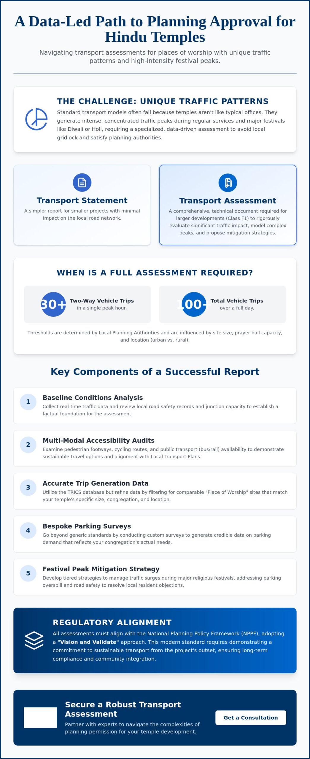
    A Hindu temple transport assessment is a specialized technical document required to evaluate the impact of a religious development on the local highway network. It differs significantly from a Transport Statement, which is typically reserved for smaller projects with minimal traffic generation. For Class F1 developments, the planning process in 2026 demands a high level of precision. This is because temples don’t follow the predictable 9-to-5 traffic patterns of an office or retail site. Instead, they produce concentrated peaks of activity that require careful modeling to avoid local gridlock.

    The National Planning Policy Framework (NPPF) serves as the primary regulatory anchor for these assessments. Currently, the industry is operating in a transition phase following the major policy review that concluded in March 2026. This means your report must reflect the latest “vision and validate” principles. Rather than just predicting traffic growth, you must demonstrate a commitment to sustainable transport and active travel from the outset. This ensures the site remains functional without placing an undue burden on existing infrastructure.

    To better understand the technical depth required for these reports, watch this helpful video:

    When is a Full Transport Assessment Required?

    Local planning authorities decide the level of reporting based on the scale of the development and its potential impact. While there’s no fixed national law, a full assessment is generally expected if the site generates more than 30 two-way vehicle movements in a single hour or over 100 movements per day. For a temple, these thresholds are often triggered by the size of the main prayer hall or the expected congregation during weekend services.

    Location significantly influences the scope of the work. Urban sites often face rigid parking caps and must prioritize public transport links. Conversely, rural developments may need to address vehicle speeds and visibility splays at site entrances. Because requirements vary between counties, we prioritize early engagement with highway officers to agree on the assessment parameters before work begins.

    The Core Components of a Temple Transport Report

    Every successful report starts with a rigorous analysis of baseline conditions. We collect real-time traffic data to understand how the local road network currently performs. This includes reviewing safety records and junction capacity to ensure the new development won’t compromise public safety. It’s about establishing a factual foundation that can withstand scrutiny from local residents and planning committees.

    Accessibility audits are equally vital. We examine the quality of pedestrian footways, the safety of cycling routes, and the frequency of nearby bus or rail services. By proving the site is accessible through multiple modes of transport, we strengthen the case for approval. This alignment with Local Transport Plans is essential for satisfying statutory consultees like National Highways or Transport for London.

    Technical Data: Trip Generation and Parking Standards

    Accurate data is the foundation of any Hindu temple transport assessment. We utilize the TRICS database to predict vehicle movements, but “Place of Worship” data can be broad and occasionally misleading. Following official government guidance, we ensure the selected data set matches the specific operational characteristics of your site. This involves filtering results to find comparable locations that mirror your temple’s size and geographic setting.

    Finding truly comparable sites is often the most significant hurdle in the planning process. A temple in a dense urban center operates differently than a suburban facility. We refine these models by analyzing congregation size and specific catchment areas. This level of precision prevents the Highway Authority from overestimating traffic impact based on generic or outdated data. Our team specializes in identifying these nuances to build a credible case for your development.

    Parking accumulation studies are equally vital for a successful application. We don’t just count cars; we analyze how long they stay and when they arrive. If you need to justify a lower number of on-site spaces, professional Parking Surveys provide the evidence required. These surveys prove whether local on-street capacity can safely handle overflow during peak times without causing a nuisance to neighbors. You can view our full range of technical traffic engineering services to see how we support complex applications with site-specific data.

    Calculating Trip Generation for Religious Festivals

    Standard Sunday peaks don’t represent the full operational reality of a temple. For major festivals like Diwali or Holi, we use survey data from existing temples to demonstrate how car-sharing reduces the total number of vehicles. High vehicle occupancy is a common cultural trait within the Hindu community. By documenting an average of three to four people per car, we can significantly lower trip rate estimates in the Hindu temple transport assessment, making the project more acceptable to planners.

    This strong sense of community often extends to shared travel experiences; for those interested in organizing group visits to spiritual landmarks in India or Southeast Asia, you can learn more about Tailormade Journeys Limited.

    Meeting (and Challenging) Local Parking Standards

    UK planning policy continues to shift toward maximum parking standards to discourage private car use. In high PTAL areas, particularly across London, we frequently justify “Zero-Parking” schemes for new religious developments. However, we must still strictly adhere to 2026 requirements for disabled bays and electric vehicle (EV) charging points. We balance these rigid standards with practical site layouts that prioritize safety and accessibility for all visitors, regardless of how they choose to travel.

    Overcoming Objections: Managing Festival Peaks and Congestion

    The most frequent objection to new religious developments is the perceived impact on the local road network during major events. While a site might function perfectly on a weekday afternoon, resident concerns focus on the high-intensity peaks of Diwali, Holi, or Janmashtami. A successful Hindu temple transport assessment must address these fears with technical precision rather than vague promises. We utilize site-specific Traffic Surveys to establish exactly how much spare capacity exists at nearby junctions. This data allows us to prove that the network can absorb temporary increases in volume when the right management is in place.

    We implement tiered mitigation strategies to separate daily operations from peak festival management. According to official government guidance, mitigation must be proportionate to the impact of the development. For standard days, the focus remains on onsite parking and pedestrian safety. For festivals, we deploy advanced measures such as temporary traffic marshals, off-site parking agreements, and pre-booked arrival slots. This proactive approach reassures the Highway Authority that the community has a clear, actionable plan for every scenario.

    The Role of a Robust Travel Plan

    A Travel Plan is a dynamic document that sets measurable targets for reducing single-occupancy car journeys. We often propose shuttle bus services from local rail stations during major festivals to intercept visitors before they reach the site. Appointing a Travel Plan Coordinator is a critical step in this process. This individual monitors community compliance and ensures that sustainable travel initiatives remain effective long after the planning permission is granted. It turns a technical report into a living commitment to local road safety and civic responsibility.

    Swept Path Analysis for Temple Sites

    Temple forecourts are often architecturally complex and space-constrained. We use Swept Path Analysis to simulate the movement of refuse vehicles, fire tenders, and coaches within these tight spaces. It’s vital to demonstrate that emergency vehicles can access the site and exit in a forward gear without requiring dangerous multiple-point turns. We also ensure that delivery vehicles and visitor coaches can complete “In and Out” manoeuvres safely without obstructing the public highway. Our engineers utilize AutoTURN software to verify vehicle swept paths, which prevents costly layout revisions during the late stages of the planning phase.

    Hindu Temple Transport Assessment

    Successful planning outcomes depend on early collaboration with the Local Highway Authority. Before submitting your Hindu temple transport assessment, you should engage in pre-application discussions to agree on the study area and the scope of junction modeling. This proactive step prevents the rejection of your technical data later in the process. It also provides a platform to address resident concerns before they escalate into formal objections during the public consultation phase. We manage these early-stage meetings to ensure the assessment parameters are both fair and achievable.

    When your site sits near a major A-road or motorway, National Highways will act as a statutory consultee. Their review follows DfT Circular 01/2022, which prioritizes sustainable development over road capacity expansion. If your project is in the capital, Transport for London (TfL) will assess your application against the London Plan healthy streets indicators. We coordinate these high-stakes negotiations on your behalf. Our engineers provide the technical responses needed to satisfy every regulatory body, keeping your project moving through the planning portal without unnecessary friction.

    Understanding Section 278 (S278) Requirements

    A Section 278 Agreement is necessary when your development requires changes to the existing public highway. This often happens when a new temple needs a safe vehicle entrance or a pedestrian crossing to connect to a nearby bus stop. These agreements are legally binding and involve specific financial obligations for the developer. Common S278 works include:

    • New or improved site access points for better visibility.
    • Junction widening to accommodate coach turning circles.
    • Installation of traffic signals or zebra crossings to protect visitors.
    • Footway improvements to enhance pedestrian safety and site accessibility.

    Costs for these works include the construction itself, alongside the highway authority’s fees for design checks, legal reviews, and site supervision. You’ll likely need to provide a highway bond to guarantee the works are completed to the required standard. Because these fees are not standardized and are specific to each project, early cost estimation is vital for your project budget.

    Securing Approval via Transport Statements

    For smaller religious developments, a full assessment might be unnecessary. A well-drafted Transport Statement can often satisfy the planning officer if the expected vehicle movements fall below the 30-per-hour threshold. This shorter report still requires a high level of technical accuracy to be planning-ready. We include a summary of expected visitor numbers, an analysis of local public transport, and a clear description of the proposed temple use. Precision in your data serves as the primary defence against planning appeals and costly delays. If you need professional support for your application, contact our traffic engineers for a detailed project review.

    Why Choose ML Traffic Engineers UK for Temple Developments?

    Securing planning approval for a place of worship requires a partner who understands the intersection of religious practice and highway regulations. ML Traffic Engineers UK provides a specialized service that bridges the gap between technical engineering and community focused planning. We’ve built a reputation for securing approvals for F1 Class developments by delivering precision led reports that satisfy even the most stringent local authorities. Our team manages every stage of the process in house. From the initial Traffic Surveys to the final submission of your Hindu temple transport assessment, we maintain total control over data quality and technical accuracy.

    We prioritize a safety-first approach. This protects the interests of your congregation while addressing the safety concerns raised by planning committees. For many religious organizations, this dedication to safety also involves ensuring that volunteers and staff are prepared for medical emergencies through First Medical Training Ltd. Our experts don’t just provide data; we provide solutions that reduce regulatory pressure on your team. By handling the technical lexicon and highway negotiations, we allow you to focus on the spiritual and community aspects of your development. Our readiness to act and constant availability make us a reliable partner for high-stakes infrastructure projects.

    Our Tailored Approach to Religious Sites

    Generic engineering firms often miss the nuances of religious peaking patterns. We model these specific surges with accuracy, ensuring that your application reflects the actual behavior of your community. Our extensive experience negotiating with London Boroughs and County Councils across England gives us a distinct advantage. We understand the local variations in parking standards and accessibility requirements that can make or break an application. You can contact ML Traffic Engineers UK today for a bespoke project review to discuss your site’s specific challenges.

    Case Studies: Turning Objections into Approvals

    Our track record includes numerous urban temple projects where initial resident objections threatened to derail the planning process. Through detailed Swept Path Analysis, we’ve demonstrated that even the most constrained sites can accommodate emergency vehicles and coaches safely. Our robust Travel Plans have successfully shifted the focus from car dependency to sustainable access, often convincing highway officers to support the development.

    These technical interventions do more than just secure approval. They often result in significant cost savings for our clients. By proving that certain off-site improvements are unnecessary or by negotiating fairer terms for Section 106 or Section 278 agreements, we reduce the financial burden on the developer. Every client receives direct access to our senior consultants. This ensures that high-level expertise is applied to every Hindu temple transport assessment, providing the unwavering reliability your project demands.

    Secure Your Planning Approval with Technical Precision

    Securing planning permission for a place of worship requires a strategy that balances technical compliance with community needs. We’ve explored how data-driven trip generation models and tiered festival management plans turn local objections into a clear path for approval. A professional Hindu temple transport assessment provides the technical evidence necessary to satisfy the Highway Authority and protect your development’s future.

    Founded in 2014, ML Traffic Engineers UK brings over a decade of UK planning expertise to your project. Our team delivers professional, safety-conscious reporting that meets all statutory requirements, from Swept Path Analysis to detailed Parking Surveys. We manage the full project lifecycle, ensuring your site layout is optimized for safe vehicle access and long-term regulatory compliance. Don’t let complex highway regulations or resident concerns delay your spiritual mission.

    Request a Transport Assessment Quote for Your Temple Project to receive a bespoke review from our senior consultants. We’re ready to help you build a lasting, accessible foundation for your congregation.

    Frequently Asked Questions

    Do I need a Transport Assessment for a small community temple?

    Whether you need a full Hindu temple transport assessment depends on the scale of your congregation and the expected vehicle movements. Smaller developments that generate fewer than 30 two-way vehicle movements in any hour typically only require a Transport Statement. However, if your site is in a sensitive area or has limited access, the council might still request a more detailed report to ensure local road safety isn’t compromised.

    How does a Travel Plan help in getting planning permission for a place of worship?

    A Travel Plan acts as a formal commitment to reducing car dependency and promoting sustainable transport like cycling or public transport. It helps secure planning permission by proving to the Highway Authority that you have a proactive strategy to manage visitor numbers. By setting measurable targets and appointing a coordinator, you demonstrate that the temple won’t cause long-term congestion or parking stress in the neighborhood.

    What is the Lambeth Methodology for parking surveys, and does it apply to temples?

    The Lambeth Methodology is a standard industry practice used to measure “parking stress” on local streets. While councils originally designed it for residential developments, we often adapt it for temples to prove that enough on-street capacity exists during peak service times. These surveys involve counting parked cars late at night and during your busiest weekend hours to show that visitors won’t block access for residents.

    Can the council refuse my temple application based on traffic alone?

    The council can refuse an application if the transport impact is considered “severe” under the National Planning Policy Framework. This usually happens when a development causes dangerous levels of congestion or lacks safe access for pedestrians and emergency vehicles. Our role is to provide technical data and mitigation strategies that prove the impact is manageable, preventing a refusal based on anecdotal traffic concerns from local objectors.

    How much does a Hindu temple transport assessment typically cost?

    The cost of a Hindu temple transport assessment varies significantly based on the project’s scale and the number of junctions we need to model. Factors like the requirement for manual traffic counts, the complexity of the site layout, and the need for multi-day parking surveys will influence the final fee. We provide bespoke quotes that reflect the specific technical requirements of your local highway authority and the size of your development.

    What is Swept Path Analysis and why is it required for my site?

    Swept Path Analysis uses specialized software like AutoTURN to simulate the movement of large vehicles within your site layout. It’s a mandatory requirement for most planning applications to prove that fire tenders, refuse trucks, and visitor coaches can enter and exit the site safely in a forward gear. This analysis ensures your design functions correctly before construction begins, preventing costly revisions to the site’s physical boundaries or access points.

    How do we handle traffic management for Diwali and other major festivals?

    We manage high-intensity festival peaks through a tiered Traffic Management Plan that triggers additional measures during major events. This often includes hiring professional marshals to direct cars, using off-site “park and ride” locations, and implementing a pre-booked arrival system for visitors. These measures are detailed in your transport report to reassure planners that your community can handle surges like Diwali without disrupting the wider local road network.

    What is the difference between a Transport Statement and a Transport Assessment?

    The primary difference lies in the scale of the development and the depth of the technical analysis. A Transport Statement is a concise report for smaller projects with limited traffic impact. In contrast, a full assessment is a comprehensive document that includes detailed junction modeling and a much wider study area. We determine which report you need by reviewing your floor area and expected visitor numbers against local highway authority thresholds.

    Michael Lee

    Article by

    Michael Lee

    Transport planner with over 35 years' experience.

    Disclaimer

    The content on mltraffic.co.uk, including all technical articles, guides, and resources, is provided for general informational and educational purposes only. It is not intended to constitute professional advice in traffic engineering, transportation planning, development approvals, or any other technical or legal field.
    While ML Traffic Engineers makes every reasonable effort to ensure the accuracy, completeness, and timeliness of the information published, we do not provide any warranties or representations (express or implied) regarding its reliability, suitability, or availability for any particular purpose. Any reliance you place on the content is strictly at your own risk.
    In no event shall ML Traffic Engineers, its directors, employees, authors, or affiliates be liable for any direct, indirect, incidental, special, consequential, or punitive damages (including, without limitation, loss of profits, data, or business opportunities) arising out of or in connection with the use of, or inability to use, any information provided on this website.
    The articles and guides on this site are not a substitute for engaging a qualified, professional traffic engineer to assess your specific project requirements. For tailored advice, compliance assessments, or traffic engineering services, please contact a competent professional.
    This disclaimer may be updated from time to time without notice. By accessing or using this website, you agree to be bound by the most current version of this disclaimer.

  • Transport Statement in High Wycombe: A Developer’s Guide for 2026 approvals

    Transport Statement in High Wycombe: A Developer’s Guide for 2026 approvals

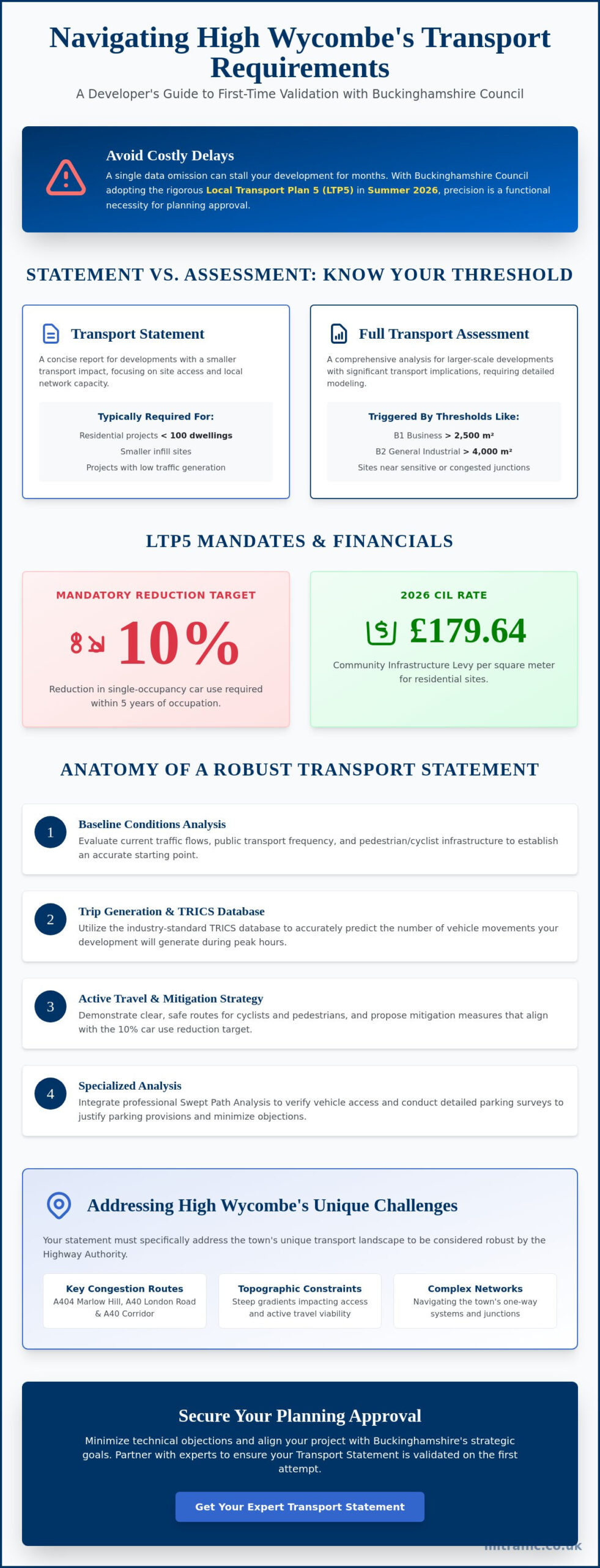
    A single data omission in your transport documentation can stall a High Wycombe development for months, especially as Buckinghamshire Council moves to adopt the rigorous Local Transport Plan 5 in Summer 2026. You likely find that navigating the unitary authority’s evolving highway requirements is a complex, high-stakes task where precision is a functional necessity. This guide ensures your transport statement High Wycombe meets every technical benchmark to secure validation on the first attempt, reducing the regulatory pressure on your project team.

    We’ll detail the specific 2026 Community Infrastructure Levy rates, such as the £179.64 per square meter for residential sites, and the exact thresholds for when a full Transport Assessment is required. You’ll gain a clear understanding of how to address the mandatory 10% reduction target for single-occupancy car use and the latest parking standards. This professional overview moves straight to the core requirements, providing a sequential roadmap from initial assessment to final planning approval.

    Key Takeaways

    • Understand the specific criteria used by Buckinghamshire Council to determine if your project requires a full Assessment or a concise Transport Statement.
    • Learn how to utilize TRICS database analysis and baseline road network data to build a robust transport statement High Wycombe developers need for first-time validation.
    • Discover strategies for mitigating High Wycombe’s unique topographic constraints and congestion on key routes like the A404 Marlow Hill.
    • Identify the critical steps in the pre-application phase to ensure your submission aligns with the latest 2026 Local Transport Plan 5 standards.
    • Explore how integrating professional Swept Path Analysis and parking surveys into your statement minimizes technical objections from the Highway Authority.

    What is a Transport Statement for High Wycombe Developments?

    A Transport Statement is a technical document required by the National Planning Policy Framework (NPPF) for developments that generate relatively low levels of traffic. It focuses on demonstrating that the local road network can safely accommodate the proposed increase in movement without causing detrimental harm. For any project in this region, a transport statement High Wycombe serves as the primary evidence base for Buckinghamshire Council to evaluate the proposal’s impact on safety and congestion.

    As the Local Highway Authority (LHA), Buckinghamshire Council uses these statements to ensure that every new access point or parking arrangement meets strict safety standards. This document is a critical part of the broader transportation planning process. It provides a data-driven justification for the development, ensuring that the highway network remains functional for all users while supporting the town’s growth.

    To better understand how technical teams evaluate your submission and the collaborative nature of this work, watch this brief overview of the transport planning environment:

    Transport Statement vs. Transport Assessment

    The distinction between these two documents depends on the scale of your development. Buckinghamshire Council follows specific thresholds to determine the level of detail required. For example, a B1 Business development exceeding 2,500 square meters or a General Industrial (B2) site over 4,000 square meters typically triggers a full Transport Assessment. Smaller infill sites or residential projects below the 100-dwelling mark usually only require a transport statement High Wycombe. Precision is vital here. The Council may upgrade a Statement to a full Assessment if the site sits near a sensitive junction or an area of known high congestion, such as the A40 corridor.

    The Legal Framework in Buckinghamshire

    Planning decisions in 2026 are governed by the Local Transport Plan 5 (LTP5), which is scheduled for adoption in the summer of 2026. This plan places a heavy emphasis on sustainable growth and reducing transport emissions. Additionally, the High Wycombe 2050 Transport Strategy provides a long-term vision for a low-emission, seamless transport system. Developers must align their proposals with these local strategies to avoid validation delays. Engaging with the LHA during the pre-application stage is the most effective way to confirm which standards apply to your specific site. It reduces the risk of costly revisions later in the planning cycle.

    Technical Components of a Robust Transport Statement

    A robust transport statement High Wycombe begins with an accurate analysis of baseline transport conditions. It’s not enough to rely on historical data; you must account for the current capacity of the local road network as of 2026. This involves evaluating existing traffic flows, public transport frequency, and the quality of pedestrian infrastructure. According to UK government guidance, the level of detail should be proportionate to the development’s scale. For High Wycombe, this means considering how your site interacts with the town’s complex one-way systems and arterial routes.

    Trip generation analysis remains the technical heart of the document. We utilize the TRICS database to predict how many vehicle movements your project will create. By 2026, these models have been refined to reflect permanent shifts in commuter behavior following the pandemic. This data allows us to propose realistic mitigation measures that offset any negative impacts on the highway. We also prioritize active travel. Your statement must demonstrate clear routes for cyclists and pedestrians, aligning with Buckinghamshire’s target to reduce single-occupancy car use by at least 10% within five years of occupation.

    Data Collection and Traffic Surveys

    High-quality data is the only way to avoid validation delays. We conduct targeted traffic surveys along critical corridors like the A40 London Road and A404 Marlow Hill to capture peak hour fluctuations. Utilising professional Parking Surveys allows us to justify development density by proving that existing street capacity or proposed on-site provision is sufficient. These surveys provide the empirical evidence that planning officers require to approve your parking ratios. Securing accurate data early prevents costly redesigns; you can contact our technical team to determine which surveys your specific site requires.

    Swept Path Analysis (SPA) in High Wycombe

    High Wycombe’s unique topography presents significant challenges for site access. The town’s steep hills and narrow residential streets require precise Swept Path Analysis to prove that emergency and service vehicles can navigate the site safely. We use digital vehicle templates for fire tenders, refuse trucks, and delivery vans to test every turn and junction. This analysis directly informs your Car Park Design, ensuring that parking bays and access roads are functional rather than just compliant on paper. SPA results often serve as the deciding factor for Highway Authority approval on constrained infill sites.

    Finally, the statement must detail site access and visibility splays. We ensure that entry and exit points meet the Manual for Streets standards or the Design Manual for Roads and Bridges (DMRB) where appropriate. Safety is the primary concern for the LHA. By presenting a clear plan for visibility and vehicle priority, we reduce the risk of the council requesting expensive revisions during the application process. Every access point must be vetted for multi-modal safety, ensuring pedestrians and cyclists are protected from vehicle conflicts.

    Transport Statement in High Wycombe: A Developer’s Guide for 2026 approvals

    High Wycombe’s infrastructure presents distinct hurdles that standard templates often overlook. The A40 London Road and A404 Marlow Hill are notorious bottlenecks that require specific attention during the planning phase. Your transport statement High Wycombe must provide a granular analysis of how your site’s trip generation impacts these corridors. We focus on identifying peak hour vulnerabilities and proposing viable entry strategies that prevent local gridlock, ensuring your project doesn’t face objections from the Highway Authority regarding cumulative impact.

    The town’s steep gradients are a significant barrier to active travel, meaning a standard audit isn’t enough for a transport statement High Wycombe. Our technical reports account for these topographic challenges by identifying the most accessible routes and evaluating the feasibility of e-scooter or e-bike integration. This is particularly relevant as the Department for Transport has extended the e-scooter rental trial in Buckinghamshire until May 2026. We ensure your accessibility strategy is realistic rather than just theoretical.

    High Wycombe also contains established Air Quality Management Areas (AQMAs). We align your transport strategy with the High Wycombe 2050 Transport Strategy, ensuring your proposal supports the town’s shift toward a low-emission, safe transport system. By addressing air quality and congestion early, we position your development as a contributor to the town’s regeneration goals rather than a logistical burden.

    Parking Standards in Buckinghamshire

    The 2026 revisions to the Buckinghamshire Countywide Parking Guidance mandate a zone-based approach to vehicle storage. High Wycombe town centre sites, classified as Zone 1, often allow for reduced parking ratios due to high public transport accessibility. Conversely, edge-of-town developments typically require higher provision to prevent overspill. If your design departs from these standards, we use robust survey data to justify the deviation, ensuring the council accepts your rationale without requiring a reduction in unit density.

    Sustainable Travel and Public Transport

    Proximity to the High Wycombe railway station provides a powerful argument for reduced car dependency in your planning submission. We quantify the benefit of direct rail links to London Marylebone and analyze the frequency of bus services operating from the Eden Bus Station. For developments exceeding 100 dwellings, integrating comprehensive Travel Plans is essential. These plans must target a 10% reduction in single-occupancy car use within five years, a benchmark we support with data-driven incentives and monitoring strategies.

    The Planning Submission and Validation Process

    The path to a successful planning approval in Buckinghamshire requires more than just submitting technical data. Once you submit your transport statement High Wycombe, it undergoes a rigorous validation check by the council’s planning team. If any mandatory element is missing, such as a recent parking survey or accurate site access plans, the application is rejected on day one. This initial delay can ripple through your entire project timeline, pushing back construction starts and increasing carry costs. We ensure every technical component aligns with the latest 2026 validation requirements to prevent these administrative setbacks.

    Engaging with Buckinghamshire Council through pre-application advice is a strategic necessity. This early consultation allows the Highway Authority to flag potential concerns regarding junction capacity or sustainable travel before the formal submission. It creates a collaborative environment where technical objections are resolved in the design phase rather than during the statutory consultation period. When the Highway Authority reviews your final submission, they look for a logical, sequential argument that proves the development is safe and policy-compliant. If you need a robust technical partner to manage this process, you can instruct our team to prepare your submission today.

    Section 278 and Section 38 Agreements

    A transport statement High Wycombe often identifies the need for physical changes to the existing road network. When your development requires off-site improvements, such as a new junction or footway extension, you must enter into Highway Design S278 & S38 agreements. These legal frameworks govern how private developers perform works on the public highway. In Buckinghamshire, these agreements are high-stakes commitments. They require precise engineering drawings and significant financial bonds. We help you identify these triggers early to ensure your project budget accounts for these infrastructure costs.

    Common Pitfalls in High Wycombe Applications

    Many applications fail due to inadequate visibility splays, particularly on the town’s steep residential hills. A splay that looks sufficient on a flat map may be obstructed by the natural topography or existing boundary walls in reality. Another frequent error is the failure to account for the cumulative impact of neighboring developments. With the High Wycombe 2050 Transport Strategy in full effect, planning officers scrutinize how your site interacts with other local growth. Relying on outdated TRICS data or failing to update your traffic surveys after the April 2026 fee changes can also lead to immediate technical objections.

    Addressing objections is an iterative part of the planning lifecycle. If the Highway Authority raises concerns, we provide rapid, data-driven revisions to resolve the issue. This technical responsiveness is vital for maintaining momentum. Once the council is satisfied, transport-related planning conditions are issued. Discharging these conditions is the final step before your development can proceed. We manage this entire lifecycle, from the first site survey to the final approval, ensuring your project remains on track and fully compliant with regional regulations.

    Expert Transport Statements with ML Traffic Engineers UK

    Securing a successful planning outcome requires a partner who understands that precision is a functional necessity. We provide the technical authority and regulatory expertise needed to navigate the specific requirements of Buckinghamshire Council. Our team maintains a professional working relationship with local planning officers, ensuring that every transport statement High Wycombe we produce aligns with the town’s unique infrastructure goals for 2026. We don’t just provide data; we deliver a robust evidence base that reduces the logistical and regulatory pressures on your development team.

    Our technical support is comprehensive and tailored to the constraints of the Home Counties. ML Traffic Engineers UK manages the delivery of specialized transport statement High Wycombe reports alongside critical sub-services like Swept Path Analysis and Traffic Surveys. By identifying potential highway objections before they reach the statutory consultation phase, we minimize planning risk for both residential and commercial developers. This proactive approach ensures that your project moves from inception to completion without the burden of unexpected technical delays or costly design revisions.

    All-Encompassing Transport Planning

    We manage the full project lifecycle, providing unwavering reliability from the initial site assessment through to the final discharge of transport conditions. Our team understands the urgency of the industry and the round-the-clock nature of infrastructure planning. Meeting tight deadlines is a core part of our service promise. In the 2026 planning environment, local expertise is a functional necessity. ML Traffic Engineers UK applies deep knowledge of High Wycombe’s road network and parking standards to ensure your submission is validated on the first attempt. Our commitment to precision ensures that every report meets the highest industry benchmarks and legislative requirements.

    Request a Quote for Your High Wycombe Project

    Getting started with your planning submission is straightforward. We provide site-specific fee proposals that reflect the exact scope of your development. To prepare an accurate quote, we require a basic site plan and a brief description of the proposed use. Whether you need a concise Statement, a detailed Parking Survey, or a complex Swept Path Analysis, we respond with the readiness and clarity your project deserves. You can Contact ML Traffic Engineers UK for a Transport Statement Quote to secure a dependable partner for your next High Wycombe application. We offer the professional integrity and technical support required to safeguard your project’s progress in a strict regulatory environment.

    Secure Your High Wycombe Development Approval

    Successfully navigating the 2026 planning landscape in Buckinghamshire requires more than just technical data; it demands a strategy that respects the unique constraints of the local highway network. From the steep gradients of the town’s residential hills to the heavy traffic volumes on the A404, every element of your submission must demonstrate a clear understanding of regional priorities. A localized approach ensures that mitigation measures are both practical and acceptable to the Highway Authority, preventing the administrative gridlock that often stalls ambitious projects.

    ML Traffic Engineers UK has been at the forefront of this field since 2014, offering over a decade of specialized UK planning experience. We maintain a deep understanding of Buckinghamshire Council’s evolving LHA requirements, specializing in the data-driven Swept Path Analysis and Parking Surveys that planning officers scrutinize most closely. Our role is to act as your technical guardian, ensuring your transport statement High Wycombe is robust, compliant, and ready for immediate validation.

    Secure your High Wycombe planning approval with a professional Transport Statement from ML Traffic Engineers UK. We are ready to help you manage the regulatory complexities of your next development with precision and reliability.

    Frequently Asked Questions

    Do I need a Transport Statement or a Transport Assessment for my High Wycombe project?

    The scale of your development determines the required document. For residential projects, a Transport Statement is typically sufficient for sites under 100 dwellings. Larger schemes or commercial developments exceeding specific square footage thresholds, such as 2,500 square meters for business use, usually require a full Assessment. We recommend a pre-application consultation to confirm the exact requirements for your site, as the Local Highway Authority evaluates the potential for significant movement on a case by case basis.

    What are the current parking standards for new developments in High Wycombe?

    Buckinghamshire’s 2026 guidance emphasizes a shift toward sustainable infrastructure and zone based vehicle storage. While car parking levels depend on your site’s location, all new developments must now meet strict minimums for cycle storage and electric vehicle charging points. These standards ensure that even town centre sites remain functional for modern residents. We use local survey data to justify any necessary departures from these established countywide benchmarks while maintaining safety and accessibility.

    How much does a Transport Statement cost for a Buckinghamshire planning application?

    The cost of a professional report varies based on the complexity of the site and the required data collection. Factors such as the need for peak hour traffic counts, specialized junction modeling, or detailed site visits influence the final fee. We provide site specific quotes after reviewing your initial site plan and development description. This ensures you receive a transparent, fixed fee estimate tailored to the specific technical demands of your project without hidden costs.

    Can a Transport Statement help overcome a planning refusal based on highway safety?

    Yes, a robust transport statement High Wycombe can effectively challenge a refusal by providing empirical evidence to counter subjective safety concerns. We often use detailed traffic surveys and visibility analysis to prove that a proposed access point meets national safety standards. By proposing specific mitigation measures, such as junction improvements or improved pedestrian crossings, we can demonstrate that a development will not result in an unacceptable impact on the local highway network.

    How long does it take to produce a professional Transport Statement?

    Production timelines typically range from two to four weeks depending on the scale of the required data collection. The process involves an initial site visit, conducting traffic or parking surveys, and performing the technical analysis. We prioritize efficiency to meet tight planning deadlines while ensuring every report remains fully compliant with Local Highway Authority standards. Early instruction allows us to capture survey data during neutral weeks, avoiding delays caused by school holidays or local events.

    Will I need a Swept Path Analysis as part of my Transport Statement?

    Buckinghamshire Council frequently requires Swept Path Analysis for sites with constrained access or internal road networks. This is especially true for residential developments where refuse vehicle tracking is a mandatory validation requirement. We use digital templates to prove that emergency services and delivery vans can enter and turn within the site safely. Including these results in your transport statement High Wycombe significantly reduces the risk of the council requesting a costly redesign after your application is submitted.

    What is the role of the TRICS database in my planning application?

    TRICS is the industry standard database used to estimate the number of trips a new development will generate. It allows us to compare your project against data from similar established sites across the UK. By selecting comparable locations with similar public transport accessibility, we provide a realistic forecast of vehicle movements. This data driven approach is essential for justifying the impact of your project on the road network and determining if mitigation measures are necessary.

    How does Buckinghamshire Council handle sustainable travel requirements in 2026?

    In 2026, the council prioritizes the integration of transport and development planning through the Local Transport Plan 5. This includes a strong focus on digital connectivity to reduce the need for travel and the implementation of Travel Plans for larger sites. Developers should note that monitoring fees apply for residential sites of 100 dwellings or more. We ensure your statement highlights high quality pedestrian links and proximity to the Eden Bus Station to meet these aggressive sustainability targets.

    Michael Lee

    Article by

    Michael Lee

    Transport planner with over 35 years’ experience.

    Disclaimer

    The content on mltraffic.co.uk, including all technical articles, guides, and resources, is provided for general informational and educational purposes only. It is not intended to constitute professional advice in traffic engineering, transportation planning, development approvals, or any other technical or legal field.
    While ML Traffic Engineers makes every reasonable effort to ensure the accuracy, completeness, and timeliness of the information published, we do not provide any warranties or representations (express or implied) regarding its reliability, suitability, or availability for any particular purpose. Any reliance you place on the content is strictly at your own risk.
    In no event shall ML Traffic Engineers, its directors, employees, authors, or affiliates be liable for any direct, indirect, incidental, special, consequential, or punitive damages (including, without limitation, loss of profits, data, or business opportunities) arising out of or in connection with the use of, or inability to use, any information provided on this website.
    The articles and guides on this site are not a substitute for engaging a qualified, professional traffic engineer to assess your specific project requirements. For tailored advice, compliance assessments, or traffic engineering services, please contact a competent professional.
    This disclaimer may be updated from time to time without notice. By accessing or using this website, you agree to be bound by the most current version of this disclaimer.
  • Multimodal Traffic Generation in London: A Developer’s Checklist for PTAL and Use Classes in 2026

    Multimodal Traffic Generation in London: A Developer’s Checklist for PTAL and Use Classes in 2026

    What if the 2020 Use Class overhaul actually makes it harder to justify your London development’s car-free status? Securing planning approval in 2026 requires a flawless understanding of multimodal traffic generation by PTAL and Land Uses (E, B2, B8, C1, C2, C3, F1, F2) and Sui Generis ( pubs/bars, cinemas, hot food takeaways, theatres, scrap yards, and petrol stations). You likely already know that London’s planning environment is increasingly rigid regarding parking provisions, especially in areas with a PTAL rating of 5 or 6. We understand the frustration of interpreting conflicting TRICS data when trying to prove your site’s accessibility to Transport for London (TfL).

    This expert-led checklist ensures your transport assessment stands up to the strictest scrutiny from local planning authorities. You’ll master the nuances of trip generation for complex sites, from Class E commercial hubs to specialised Sui Generis scrap yards and petrol stations. We’ve compiled a clear roadmap for accurate data collection and site layout optimisation to help you achieve planning approval with minimal revisions. We’ll examine how to align your project with the latest London Plan requirements to ensure a seamless transition from the initial CAD design to final implementation.

    Key Takeaways

    • Understand how PTAL ratings act as a critical planning gatekeeper by defining the sustainable density and scale of developments across London’s 32 boroughs.
    • Learn to calculate accurate multimodal traffic generation by PTAL and Land Uses (E, B2, B8, C1, C2, C3, F1, F2) and Sui Generis ( pubs/bars, cinemas, hot food takeaways, theatres, scrap yards, and petrol stations) using the TRICS database and bespoke arrival profiles.
    • Discover why Sui Generis developments require specialised traffic analysis to account for unique arrival and departure patterns that generic data often overlooks.
    • Utilise our 2026 developer’s checklist to identify Use Class overlaps early and verify site accessibility using the latest TfL WebPTAL tools.
    • Mitigate the risk of costly planning delays by leveraging professional transport consultants to navigate the specific regulatory requirements of individual London local authorities.

    Table of Contents

    Decoding London’s Use Classes and PTAL Ratings for 2026

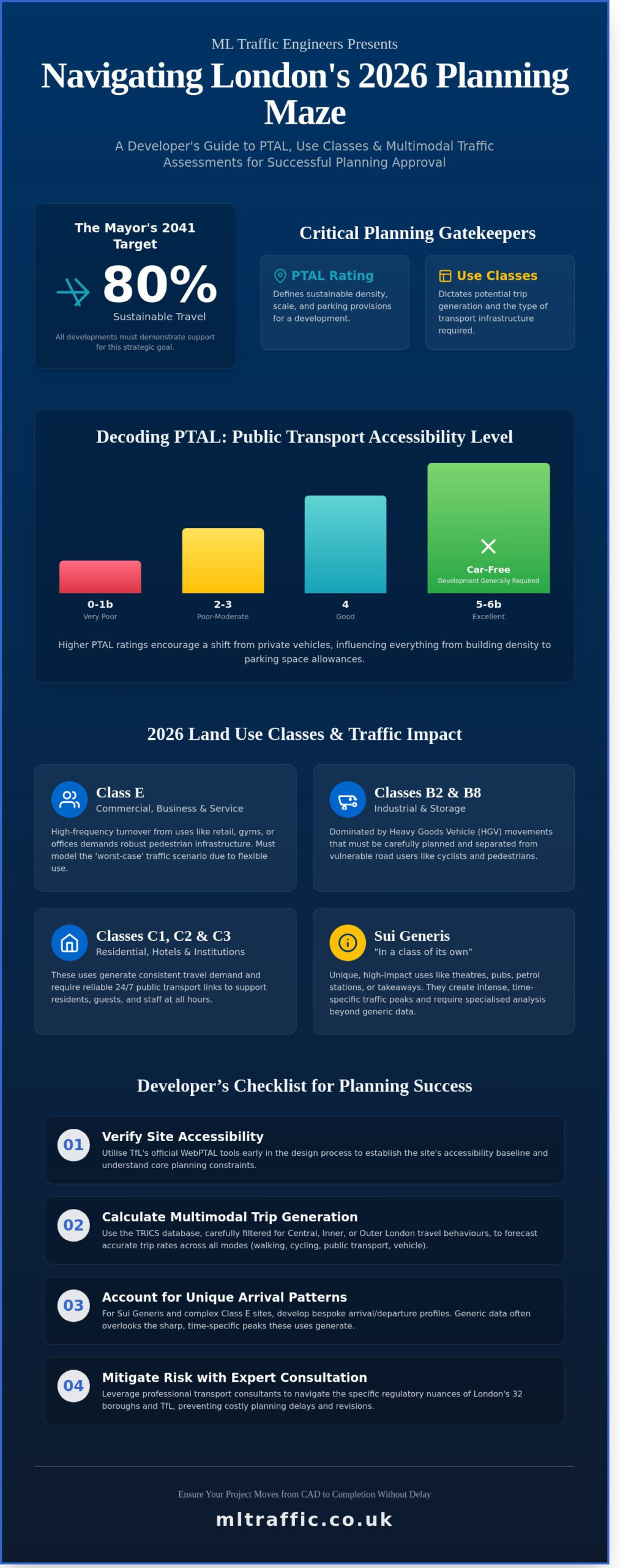
    London’s planning framework requires a strict correlation between the Use Classes Order 1987 and the city’s strategic transport goals. Developers must demonstrate how their projects support the Mayor’s 2041 target for 80% sustainable travel. A central component of this is the Public Transport Accessibility Level (PTAL), which measures the proximity and frequency of the transport network. This metric serves as a critical gatekeeper, dictating everything from building density to the number of permitted parking spaces.

    To better understand how these planning elements work together, watch this helpful video:

    What is PTAL and Why Does it Matter?

    PTAL scores range from 0 to 6b. Higher numbers represent superior access to rail, tube, and bus services. In 2026, sites with a PTAL of 5 or 6 generally require car-free development, with exceptions limited to essential blue badge provision. These ratings directly influence how residents and visitors choose to travel. High accessibility encourages a shift from private vehicles to active travel and public transport. When developers seek to deviate from these rigid standards, parking surveys in London provide the empirical data needed to justify parking reductions. We use these surveys to prove that local streets can handle any residual overspill without compromising safety.

    The 2026 Landscape of Land Use Classes

    The introduction of Class E has streamlined planning but complicated transport modelling for consultants. Since a building can shift from a retail shop to a gym or office without additional planning permission—often housing the kind of small UK businesses found on platforms like Anglia Market—we must model the “worst-case” scenario for trip generation. This ensures safety and capacity compliance regardless of the specific end-user. Accurate forecasting of multimodal traffic generation by PTAL and Land Uses (E, B2, B8, C1, C2, C3, F1, F2) and Sui Generis ( pubs/bars, cinemas, hot food takeaways, theatres, scrap yards, and petrol stations) is now the mandatory baseline for any successful planning application.

    Each land use presents unique challenges for the 2026 transport network:

    • Class E: High-frequency turnover requiring robust pedestrian infrastructure.
    • B2 and B8: Heavy goods vehicle (HGV) movements that must be separated from cycle lanes.
    • C1 to C3: Residential and hotel uses that demand reliable 24/7 public transport links.
    • Sui Generis: High-impact uses like theatres or petrol stations that create intense, time-specific traffic peaks.

    Our team ensures that your project meets these technical requirements from the initial planning phase. We provide the precise data needed to satisfy local authorities and Transport for London, ensuring your development moves from CAD design to final implementation without regulatory delays.

    Calculating Trip Generation for Classes E, B, and C

    Accurate forecasting starts with the TRICS database. It’s the industry standard for establishing baseline multimodal trip rates. However, London’s unique geography requires developers to filter national datasets to match the specific travel behaviours of Central, Inner, or Outer London. A site in Croydon won’t share the same trip profile as one in Southwark, even if the land use is identical. It’s vital to follow official government guidance when preparing these figures to ensure compliance with local planning authority expectations.

    Our methodology ensures precise multimodal traffic generation by PTAL and Land Uses (E, B2, B8, C1, C2, C3, F1, F2) and Sui Generis ( pubs/bars, cinemas, hot food takeaways, theatres, scrap yards, and petrol stations) to meet strict Transport for London (TfL) standards. We don’t just look at vehicle numbers; we calculate the total impact across all transport modes. This includes cycling, walking, and rail usage, which are heavily influenced by the site’s PTAL rating. For projects requiring rapid turnaround, our comprehensive transport planning support ensures your submission stays on track.

    Commercial and Industrial Dynamics (E, B2, B8)

    B8 Storage and Distribution centres in Greater London generate intense delivery and servicing requirements. These sites often see over 15 HGV movements per hour during peak operational windows. Because of these dimensions, swept path analysis services are vital for industrial site access. They prove that large vehicles can enter and exit in a forward gear without mounting pavements or striking street furniture. Class E traffic has also shifted significantly. Since the 2020 reforms, many sites have moved from retail-heavy use to office and gym multimodal splits. This change typically flattens the midday peak but increases pressure during the 08:00 to 09:00 and 17:00 to 18:00 windows.

    Residential and Institutional Impact (C1, C2, C3, F1, F2)

    Forecasting school (F1) and community (F2) traffic requires a granular look at the morning peak hour. These uses often create localised congestion that conflicts with commuter traffic. Residential (C3) developments in low PTAL areas, such as levels 1a or 1b, typically show a 40% higher car dependency compared to Zone 2 locations. In contrast, short-stay C1 uses operate on a different rhythm. C1 hotel trip generation varies significantly by proximity to London Underground stations, with sites within 250 metres showing a 70% reduction in taxi and private car arrivals. Balancing these peak hour pressures is essential for securing planning approval in 2026. For residential schemes that include new roads intended for public adoption, understanding the section 38 agreement process in London from the outset is critical to avoiding costly delays before the first resident moves in.

    Multimodal Traffic Generation in London: A Developer’s Checklist for PTAL and Use Classes in 2026

    The Sui Generis Factor: Traffic Nuances for Pubs, Theatres, and Takeaways

    Sui Generis developments fall outside standard classifications because their impact on the road network is entirely unique. Relying on generic TRICS averages often leads to planning refusals in London. Local authorities require bespoke data that reflects the specific operational hours and visitor behaviours of your site. Accurate multimodal traffic generation by PTAL and Land Uses (E, B2, B8, C1, C2, C3, F1, F2) and Sui Generis ( pubs/bars, cinemas, hot food takeaways, theatres, scrap yards, and petrol stations) ensures your transport assessment stands up to scrutiny during the 2026 planning cycle. We focus on the granular details of how these sites breathe throughout a 24-hour period.

    Hospitality and Entertainment (Pubs, Cinemas, Theatres)

    Entertainment venues create intense surge peaks rather than steady flows. A 500-seat theatre generates a massive exodus within a 15-minute window at 22:30, which differs significantly from a Class E office. We calculate the linked trip effect, where approximately 30% of visitors might visit a local pub before a film, reducing the demand for new parking but increasing pavement crowding. Effective London travel plans help mitigate these dispersal risks by coordinating with TfL night services and designated taxi pick-up points. Managing late-night noise and transport dispersal is critical for sites near residential zones.

    Hot food takeaways present a different challenge: moped volume. A single busy unit can generate 20 to 30 delivery trips per hour during peak evening times. This requires dedicated waiting bays to prevent illegal pavement parking and maintain road safety for cyclists. Without these provisions, the high-frequency nature of delivery traffic often triggers objections from Highways officers. We design layouts that keep mopeds off the footway and ensure delivery drivers don’t obstruct the main carriageway.

    Industrial Sui Generis: Scrap Yards and Petrol Stations

    Industrial Sui Generis sites demand precision in vehicle tracking. Scrap yards and petrol stations operate with heavy, oversized vehicles that cannot easily navigate tight London corners. We use CAD-based swept path analysis to prove that a 16.5-metre petrol tanker or a recovery low-loader can enter and exit the site in a forward gear. This is a non-negotiable safety requirement for 2026 applications.

    • High-Turnover Flow: Petrol stations require clear stacking space to prevent queues from backing up onto the public highway.
    • Environmental Safety: Mitigating the impact of heavy vehicle movements on residential fringes involves strict routing agreements and physical mitigation measures.
    • Operational Precision: We ensure site layouts accommodate the maximum legal vehicle size allowed on UK roads to prevent kerb strikes and pedestrian risk.

    Our team provides the technical authority needed to ensure these complex industrial movements don’t compromise public safety. Precision in these calculations isn’t just a regulatory hurdle; it’s a fundamental requirement for site viability. We provide the total managed solution from initial data collection to final implementation.

    A Developer’s Checklist for Multimodal Traffic Assessments

    Precision in the early planning stages prevents costly delays during the 2026 planning cycle. Developers must accurately identify the correct Use Class and any Sui Generis overlaps during the initial design phase. A mixed-use development might fall under Class E, but if it includes a cinema or a hot food takeaway, it triggers specific Sui Generis requirements that alter the entire traffic profile. Failing to spot these overlaps early often leads to significant revisions after the Highway Authority review.

    Confirm your site’s PTAL rating using the TfL WebPTAL tool specifically for 2026. This rating is the foundation for your maximum parking allowance and trip generation forecasts. When pulling data from the TRICS database, don’t rely on national averages. Select comparable London-specific sites that match the capital’s unique density and low car ownership levels. This ensures your multimodal traffic generation by PTAL and Land Uses (E, B2, B8, C1, C2, C3, F1, F2) and Sui Generis ( pubs/bars, cinemas, hot food takeaways, theatres, scrap yards, and petrol stations) reflects reality rather than theoretical models.

    • Identify Use Class and Sui Generis overlaps before finalizing site layouts.
    • Use the 2026 TfL WebPTAL tool to set baseline accessibility scores.
    • Filter TRICS data for London-only sites to ensure demographic accuracy.
    • Include a Delivery and Servicing Plan (DSP) to manage freight and courier movements.
    • Engage transportation consultants for pre-application meetings to align with borough-specific expectations.

    Data Collection and Site Survey Requirements

    Baseline flows must be established through 7-day automated traffic counts (ATCs). This timeframe captures the weekend spikes associated with Sui Generis uses like theatres or pubs which a standard 12-hour count might miss. Identify local pinch points, such as narrow junctions or low bridges, that could necessitate a full Transport Assessment. You also need to verify pedestrian and cycle catchment areas. This involves auditing local infrastructure to prove that multimodal accessibility is a viable alternative to car travel for future occupants.

    Policy Compliance and Reporting

    Your report must demonstrate strict adherence to the London Plan 2021 (and subsequent 2026 updates) regarding car-free or car-capped developments. If your multimodal traffic generation by PTAL and Land Uses (E, B2, B8, C1, C2, C3, F1, F2) and Sui Generis ( pubs/bars, cinemas, hot food takeaways, theatres, scrap yards, and petrol stations) shows capacity issues, you must draft a Mitigation Strategy. This might include funding local bus frequency improvements or installing new cycle lanes. A Transport Statement must justify how the development promotes Healthy Streets objectives through active travel and improved public realm safety.

    Ensure your project meets every regulatory hurdle with expert guidance. Contact ML Traffic for professional transport planning support today.

    Why Expert Transportation Consultants are Vital for London Planning

    London’s 32 boroughs operate with distinct local plans and varied transport hierarchies. A project in Westminster faces different parking ratios and cycle storage mandates than one in Havering. Professional data collection eliminates guesswork and prevents the 4-6 week delays often triggered by incomplete transport assessments during the statutory consultation period. ML Traffic Engineers provide 24/7 availability for site surveys. This ensures that if a planning officer requests an emergency revision on a Tuesday morning, the data is collected by Wednesday night. Such readiness is a non-negotiable asset in the fast-moving London development market.

    Accurate forecasting of multimodal traffic generation by PTAL and Land Uses (E, B2, B8, C1, C2, C3, F1, F2) and Sui Generis ( pubs/bars, cinemas, hot food takeaways, theatres, scrap yards, and petrol stations) is the foundation of a successful application. We provide the technical precision required to satisfy Transport for London (TfL) and local highway authorities. By positioning ML Traffic Engineers as your safe pair of hands, you ensure that every CAD design and multi-way system is compliant with current UK road regulations. Our approach balances technical authority with a focus on your project’s timeline.

    Navigating the Planning Process with Precision

    Technical authority in a Transport Statement builds immediate trust with Council Officers. We’ve managed projects where expert negotiation reduced Section 106 transport contributions by 18% through more accurate trip generation modelling. For Sui Generis sites like scrap yards or large-scale theatres, the impact on the local highway network is scrutinised heavily. In a 2024 project for a Greater London Sui Generis site, our detailed junction analysis proved that existing infrastructure could handle peak-hour loads. This saved the developer over £25,000 in redundant mitigation costs and ensured Section 278 agreements remained proportionate. Developers seeking to understand the full scope of their obligations should review the requirements for highway design S278 S38 compliance to avoid unexpected costs during the technical approval stage.

    Total Managed Solutions for Developers

    Our team handles the entire lifecycle, from initial feasibility and PTAL analysis to final Swept Path drawings. We’re a London-based team that understands how local traffic behaves on a Friday night in Soho versus a Monday morning in Croydon. This local intelligence ensures your project is both compliant and physically viable. When calculating multimodal traffic generation by PTAL and Land Uses (E, B2, B8, C1, C2, C3, F1, F2) and Sui Generis ( pubs/bars, cinemas, hot food takeaways, theatres, scrap yards, and petrol stations), we use the most recent TRICS data to provide a robust evidence base. We provide bespoke solutions including Chapter 8 compliance and temporary traffic signals. Our goal is to alleviate the regulatory burden on project managers through seamless integration. Contact ML Traffic Engineers for a bespoke transport quote today.

    Future-Proof Your London Development Strategy

    Navigating the complexities of London’s evolving planning framework requires more than just a surface-level understanding of transport data. Developers must master the technical intersection of PTAL ratings and specific site requirements to meet 2026 standards. Whether you’re converting an office to Class C3 residential or managing a high-impact Sui Generis site, precision in your transport assessment is the difference between approval and costly delays. Accurate data ensures your project aligns with the rigorous safety and environmental benchmarks set by local authorities.

    Effective planning hinges on precise multimodal traffic generation by PTAL and Land Uses (E, B2, B8, C1, C2, C3, F1, F2) and Sui Generis ( pubs/bars, cinemas, hot food takeaways, theatres, scrap yards, and petrol stations). Since 2014, ML Traffic Engineers has supported developers with over a decade of hands-on experience navigating TfL and London Borough requirements. We provide 24/7 availability for urgent traffic and parking surveys, ensuring your project remains on schedule regardless of the deadline. Our team manages every stage from initial planning to final implementation with a focus on absolute legislative compliance. For developments that require new or altered highway infrastructure, understanding your S278 and S38 highway design obligations from the outset is essential to protecting your programme and budget.

    Secure your planning approval with expert transport reports from ML Traffic Engineers. Your project deserves the reliability of a partner who understands the intricate realities of the UK’s road regulations. Let’s get your development moving forward today.

    Frequently Asked Questions

    What is the difference between a Transport Statement and a Transport Assessment for Sui Generis uses?

    The primary difference lies in the scale of the development’s impact on the local road network. A Transport Statement is a concise report for smaller Sui Generis projects, like a single scrap yard or a small pub, where trip generation is limited. You’ll need a full Transport Assessment for larger schemes, such as a 500 seat cinema or a major theatre, that exceed the 1,000 square metre threshold or generate more than 30 vehicle movements during peak hours.

    How does a high PTAL rating affect the number of parking spaces I can provide in London?

    A high PTAL rating of 5 or 6 usually forces a car-free approach for most developments under the 2021 London Plan. In these high-accessibility areas, you’re restricted to providing only essential spaces, such as those for blue badge holders. This policy directly influences multimodal traffic generation by PTAL and Land Uses (E, B2, B8, C1, C2, C3, F1, F2) by shifting the focus from private vehicles to London’s rail and bus networks.

    Can I change a building from Class E to a Sui Generis use like a takeaway without planning permission?

    You can’t change a Class E site to a Sui Generis hot food takeaway without submitting a full planning application. While Class E allows flexibility between shops, offices, and gyms, takeaways don’t fall under permitted development rights. You’ll need to provide the local authority with a detailed assessment of delivery driver movements and noise impacts to secure approval for this specific change of use.

    What is the TRICS database and why do transportation consultants use it for trip generation?

    The Trip Rate Information Computer System (TRICS) is the industry-standard database used to predict multimodal traffic generation by PTAL and Land Uses across the UK. It contains over 8,000 site surveys that allow consultants to calculate expected arrivals by foot, cycle, and car. We use this data to provide a robust evidence base for your planning application, ensuring your projected trip rates are validated against similar existing developments.

    How much does a multimodal traffic survey cost for a small London development?

    A standard multimodal traffic survey for a small London site typically costs between £1,500 and £3,500. This price includes the installation of Automatic Traffic Counters and manual counts over a 12 hour period to capture peak flow data. Costs can rise to £5,000 or more if your project requires complex junction analysis or 24/7 monitoring to satisfy Transport for London’s strict data requirements.

    Is a Travel Plan mandatory for all Class C3 residential developments in London?

    A Travel Plan isn’t mandatory for every residential project, but you’ll almost certainly need one if your development exceeds 80 units. For smaller schemes between 50 and 80 units, the borough might only request a simplified Travel Plan Statement. These documents are vital for managing long-term traffic impact and are often secured through a Section 106 legal agreement to ensure the development meets the Mayor’s 80 percent sustainable travel target by 2041.

    What happens if my development’s traffic generation exceeds local road capacity?

    If your projected traffic exceeds the capacity of the local highway, the council may refuse your application or require significant mitigation measures. You might have to pay for junction upgrades, install new temporary traffic signals, or contribute to local bus service improvements via a Section 106 agreement. We identify these capacity issues early in the design phase to create bespoke engineering solutions that protect your project’s viability.

    How often does TfL update the PTAL ratings for London boroughs?

    Transport for London updates the underlying WebCAT data continuously to reflect minor timetable changes, but major PTAL map revisions usually happen once a year. Significant shifts in accessibility scores occurred in 2023 following the full integration of the Elizabeth Line into the network. It’s essential to check the latest 2024 or 2025 data sets before submitting your application, as a change in PTAL score can instantly alter your parking obligations.

    Which areas in London do you cover?

    We service Acton, Balham, Barking, Barnes, Barnet, Battersea, Beckenham, Bexleyheath, Brentford, Brixton, Bromley, Camberwell, Carshalton, Charlton, Chelsea, Chiswick, Clapham, Coulsdon, Croydon, Crystal Palace, Dagenham, Dulwich, Ealing, Edgware, Eltham, Enfield, Finchley, Forest Gate, Fulham, Golders Green, Greenwich, Hackney, Hammersmith, Hampstead, Harrow, Hayes, Highgate, Hounslow, Ilford, Islington, Kensington, Kentish Town, Kingston upon Thames, Lewisham, Mitcham, Muswell Hill, New Malden, Notting Hill, Orpington, Peckham, Pinner, Purley, Putney, Richmond, Romford, Ruislip, Sidcup, Southall, Southgate, Streatham, Surbiton, Sutton, Tooting, Tottenham, Twickenham, Uxbridge, Walthamstow, Wembley, West Norwood, Wimbledon, Wood Green, Woolwich, Bethnal Green, Shoreditch, Canary Wharf, Deptford, Leyton, Palmers Green, Stanmore, Upminster, Chislehurst, Erith, Feltham.

    Which cities in England do you cover?

    We service London, Birmingham, Manchester, Liverpool, Sheffield, Leeds.

    Michael Lee

    Article by

    Michael Lee

    Transport planner with over 35 years’ experience.

    Disclaimer

    The content on mltraffic.co.uk, including all technical articles, guides, and resources, is provided for general informational and educational purposes only. It is not intended to constitute professional advice in traffic engineering, transportation planning, development approvals, or any other technical or legal field.
    While ML Traffic Engineers makes every reasonable effort to ensure the accuracy, completeness, and timeliness of the information published, we do not provide any warranties or representations (express or implied) regarding its reliability, suitability, or availability for any particular purpose. Any reliance you place on the content is strictly at your own risk.
    In no event shall ML Traffic Engineers, its directors, employees, authors, or affiliates be liable for any direct, indirect, incidental, special, consequential, or punitive damages (including, without limitation, loss of profits, data, or business opportunities) arising out of or in connection with the use of, or inability to use, any information provided on this website.
    The articles and guides on this site are not a substitute for engaging a qualified, professional traffic engineer to assess your specific project requirements. For tailored advice, compliance assessments, or traffic engineering services, please contact a competent professional.
    This disclaimer may be updated from time to time without notice. By accessing or using this website, you agree to be bound by the most current version of this disclaimer.