Tag: planning permission

  • London ULEZ and Construction: The Developer’s 2026 Guide to Compliance

    London ULEZ and Construction: The Developer’s 2026 Guide to Compliance

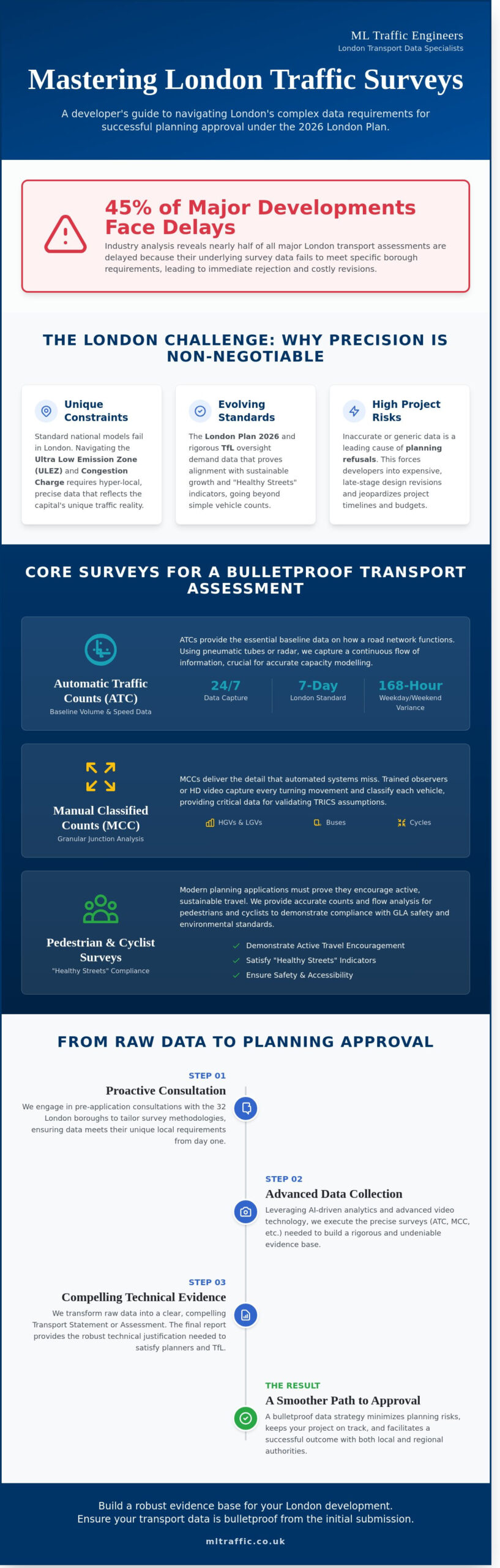
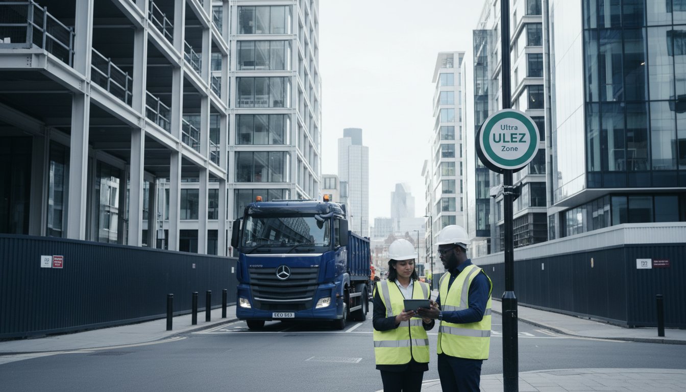
    What if the most significant threat to your project’s 2026 profit margin isn’t material inflation, but a daily £300 charge for every non-compliant heavy vehicle entering your site? The evolving landscape of london ulez construction requirements means that technical precision in your logistics planning is no longer optional; it’s a legal and financial imperative. You likely find the constant shifting between LEZ, ULEZ, and Non-Road Mobile Machinery (NRMM) standards both confusing and a potential trigger for avoidable planning delays.

    We’re here to provide the technical authority you need to secure successful planning approvals and maintain a cost-effective site. This guide delivers a clear roadmap for 2026 compliance, ensuring your Transport Statements meet the rigorous expectations of London local authorities. We’ll break down the Euro VI standards for heavy vehicles, clarify the latest NRMM requirements for Stage V engines, and outline a strategic approach to site logistics. You’ll move from regulatory uncertainty to a position of total compliance and operational readiness.

    Key Takeaways

    • Understand why the London-wide ULEZ expansion necessitates strict adherence to emission standards across every borough for all development logistics.
    • Identify the specific Euro 6/VI and petrol standards required for vans and HGVs to ensure your fleet remains compliant and avoids daily charges.
    • Learn how to integrate london ulez construction requirements into your Transport Statements by using the TRICS database to forecast compliant vehicle movements.
    • Utilise Swept Path Analysis to account for the unique dimensions of modern Euro VI vehicles, ensuring seamless site access and planning approval.
    • Gain expert insights into navigating complex planning laws with 24/7 technical support for urgent logistics and site access revisions.

    Table of Contents

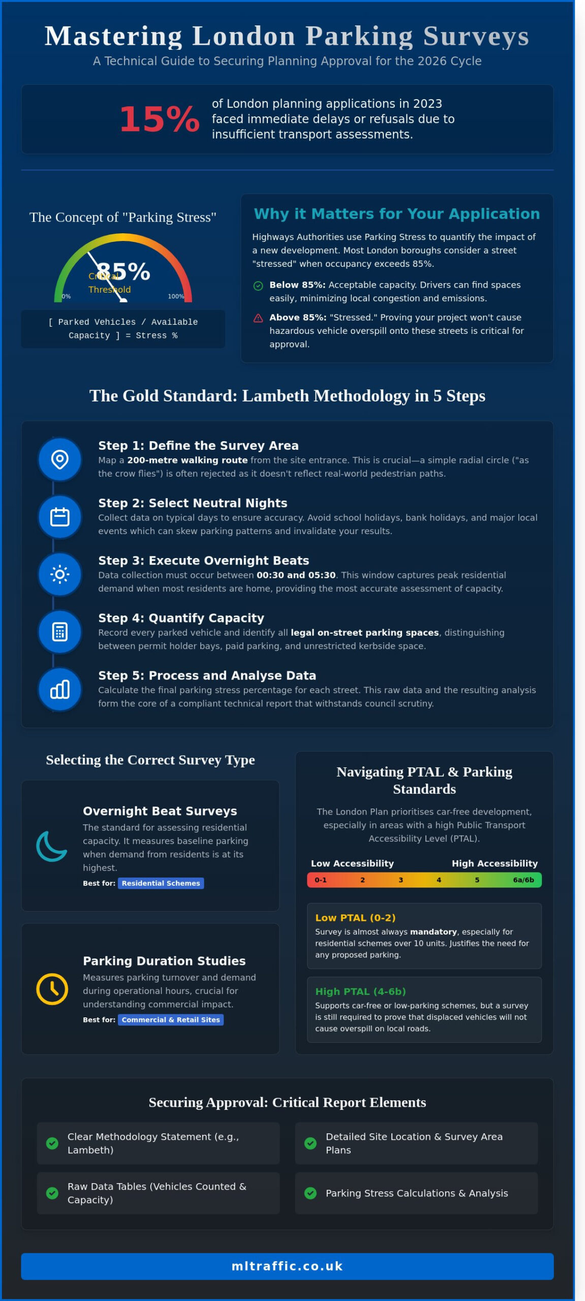
    Understanding the London ULEZ Framework for Construction Projects

    By 2026, the Ultra Low Emission Zone (ULEZ) has become the primary regulatory benchmark for

    **london ulez construction

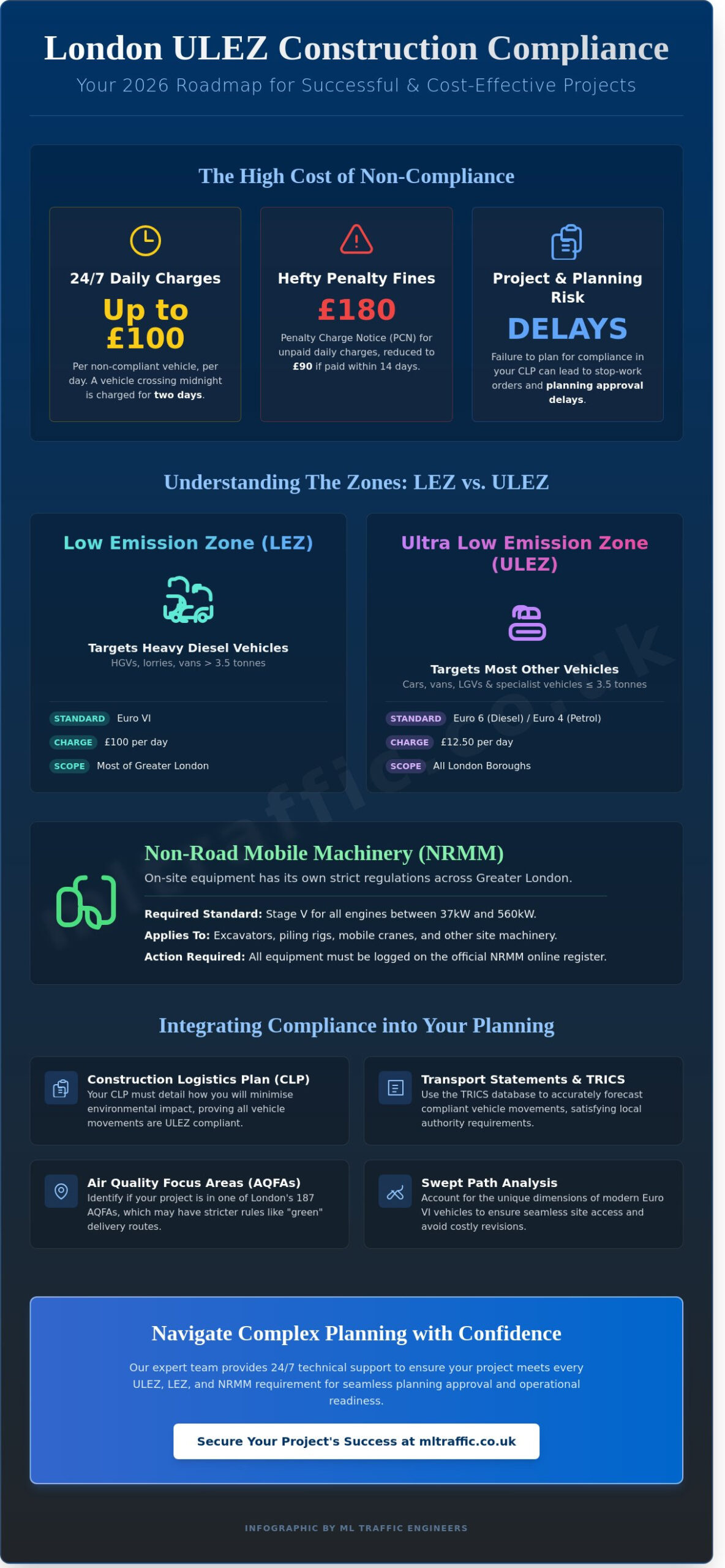
    **logistics. The zone now encompasses every London borough, stretching from Hillingdon in the west to Havering in the east. Developers must distinguish between the Low Emission Zone (LEZ) and the ULEZ to avoid significant overheads. While the LEZ focuses on heavy diesel vehicles over 3.5 tonnes, the ULEZ targets smaller vans, LGVs, and cars that don’t meet Euro 6 (diesel) or Euro 4 (petrol) standards.

    The Greater London Authority (GLA) maintains intense scrutiny on construction traffic because freight and site deliveries contribute to nearly 30% of nitrogen oxide emissions from road transport in the capital. Compliance isn’t just a daily fee; it’s a core component of modern planning obligations. Many projects now require a detailed Construction Logistics Plan (CLP) that proves how a site will minimize its environmental footprint.

    The 24/7 Nature of ULEZ Compliance

    The ULEZ operates 24 hours a day, every day of the year, with the sole exception of Christmas Day. This midnight-to-midnight charging cycle creates a logistical trap for night-time deliveries. If a non-compliant vehicle enters a site at 23:30 and departs at 00:30, the operator is liable for two separate daily charges. Transport for London (TfL) enforces this via a network of 1,400 Automatic Number Plate Recognition (ANPR) cameras. Failing to pay the £12.50 daily charge results in a Penalty Charge Notice (PCN) of £180, reduced to £90 if paid within 14 days. For a fleet of ten non-compliant delivery vans, a single week of oversight can result in fines exceeding £12,000. We provide

    [comprehensive support

    ](https://mltraffic.co.uk/what-we-do/)to help project managers coordinate these movements and maintain strict compliance.

    London Borough Specifics and Local Air Quality Management

    Baseline ULEZ rules are often just the starting point. The London Plan 2025 sets out "Air Quality Neutral" requirements that every new development must satisfy. Individual boroughs like Westminster and Camden frequently impose even tighter restrictions through Section 106 agreements. You must identify if your project falls within one of the 187 Air Quality Focus Areas (AQFAs) across London. These are locations where pollution levels are high and human exposure is greatest. In these zones, local councils may mandate specific "green" delivery routes or restrict vehicle idling times more aggressively than the standard ULEZ framework. Missing these local nuances can lead to stop-work orders or delayed permit approvals for essential road works. Developers working in north London should be particularly aware that boroughs such as Haringey present their own distinct planning challenges; partnering with specialist

    [Transport Planning Consultants Haringey

    ](https://mltraffic.co.uk/articles/transport-planning-consultants-haringey-a-developers-2026-guide-to-planning-approval/)can help navigate the council’s strict parking standards and TfL objection risks. Our team ensures that every

    [project type

    ](https://mltraffic.co.uk/project-types/)

    Vehicle Emission Standards and Non-Road Mobile Machinery (NRMM)

    Compliance on a London site depends on a clear understanding of the divide between road vehicles and site machinery. For any london ulez construction project, the 2026 standards are non-negotiable. Diesel vans and HGVs must meet Euro 6 or Euro VI standards to avoid the £12.50 or £100 daily charges. Petrol vehicles, usually lighter site cars or car-derived vans, require Euro 4. If you’re using non-UK registered specialist vehicles, you must register them with Transport for London (TfL) at least 10 days before they enter the zone. Failure to do this results in automatic daily charges, even if the vehicle technically meets the required emission levels.

    Decoding Euro VI for Heavy Goods Vehicles (HGVs)

    The technical distinction between Euro 6 and Euro VI is often misunderstood by site managers. Euro 6 applies to light commercial vehicles, while the Roman numeral VI denotes heavy-duty engines found in HGVs and large plant transporters. Euro VI standards focus on stricter NOx and particulate matter limits during real-world driving cycles. Many specialist plant vehicles built before 2014 won’t meet these requirements. Retrofitting an older HGV with an approved Selective Catalytic Reduction (SCR) system is an option, but costs often exceed £15,000 per unit. While vehicles over 40 years old can claim "historic" status, these are rarely suitable for the rigorous, high-utilisation demands of modern site logistics.

    Managing Non-Road Mobile Machinery (NRMM)

    Operating alongside the ULEZ, the NRMM Low Emission Zone targets different equipment categories. By 2026, all engines between 37kW and 560kW must meet Stage V emission standards across the entirety of Greater London. This includes excavators, piling rigs, and mobile cranes. You’re required to log every piece of equipment on the official NRMM register before it arrives on site. Local authority inspectors perform spot checks to verify that engine serial numbers match the register. Maintaining a comprehensive site log with emission certificates is the only way to avoid project delays and heavy fines. It’s a mandatory requirement that ensures your london ulez construction site stays within the law. To ensure your site logistics remain compliant from day one, consider how integrated traffic management solutions can streamline your equipment movements.

    Every piece of machinery must have its engine Stage clearly visible or documented. For generators, which are frequently used on early-stage sites, the Stage V requirement is particularly strict. If your current fleet doesn’t meet these benchmarks, you’ll need to source compliant hire equipment or invest in exhaust after-treatment systems. Precision in your record-keeping is just as important as the hardware itself, as the NRMM register is the first thing a local authority officer will request during an audit.

    London ULEZ and Construction: The Developer’s 2026 Guide to Compliance

    Integrating ULEZ Compliance into Transport Planning and Assessments

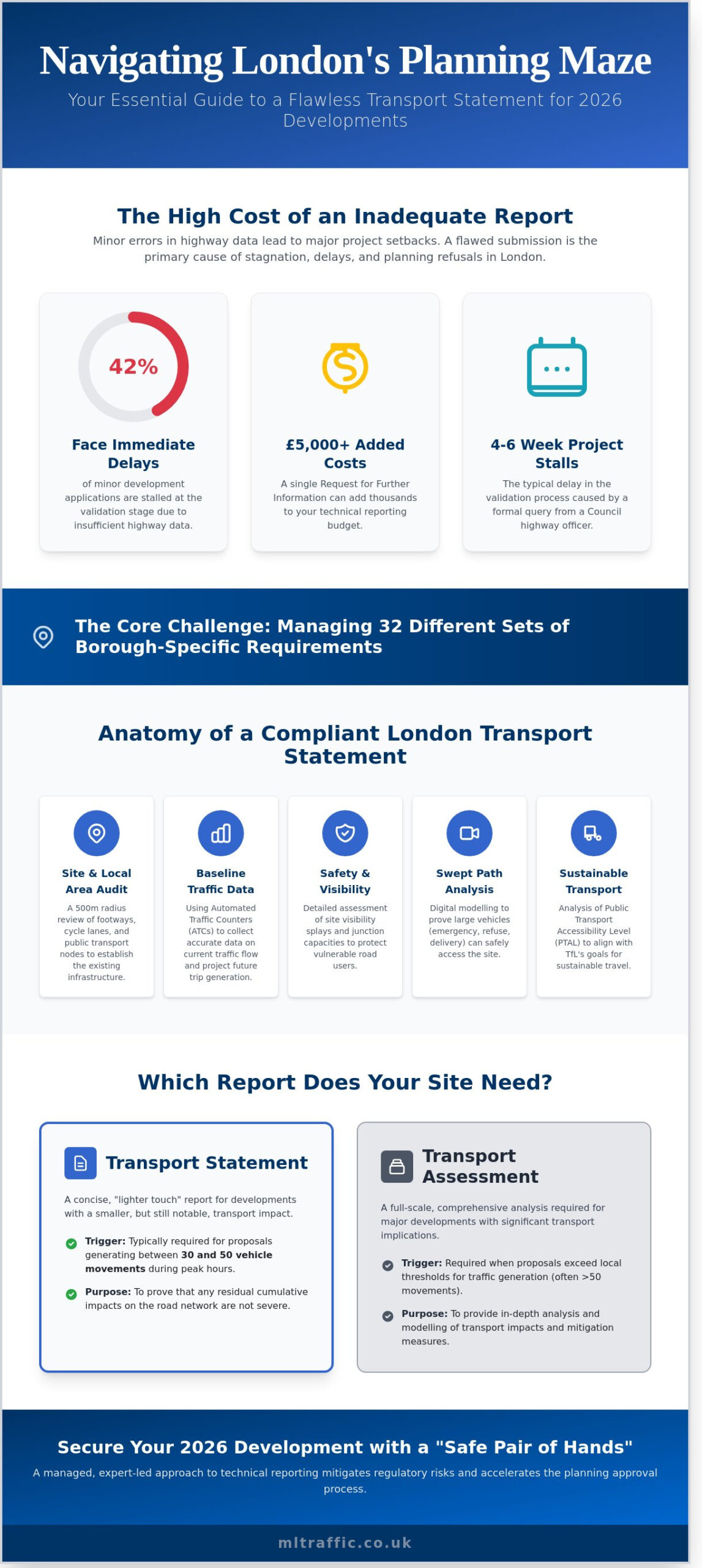
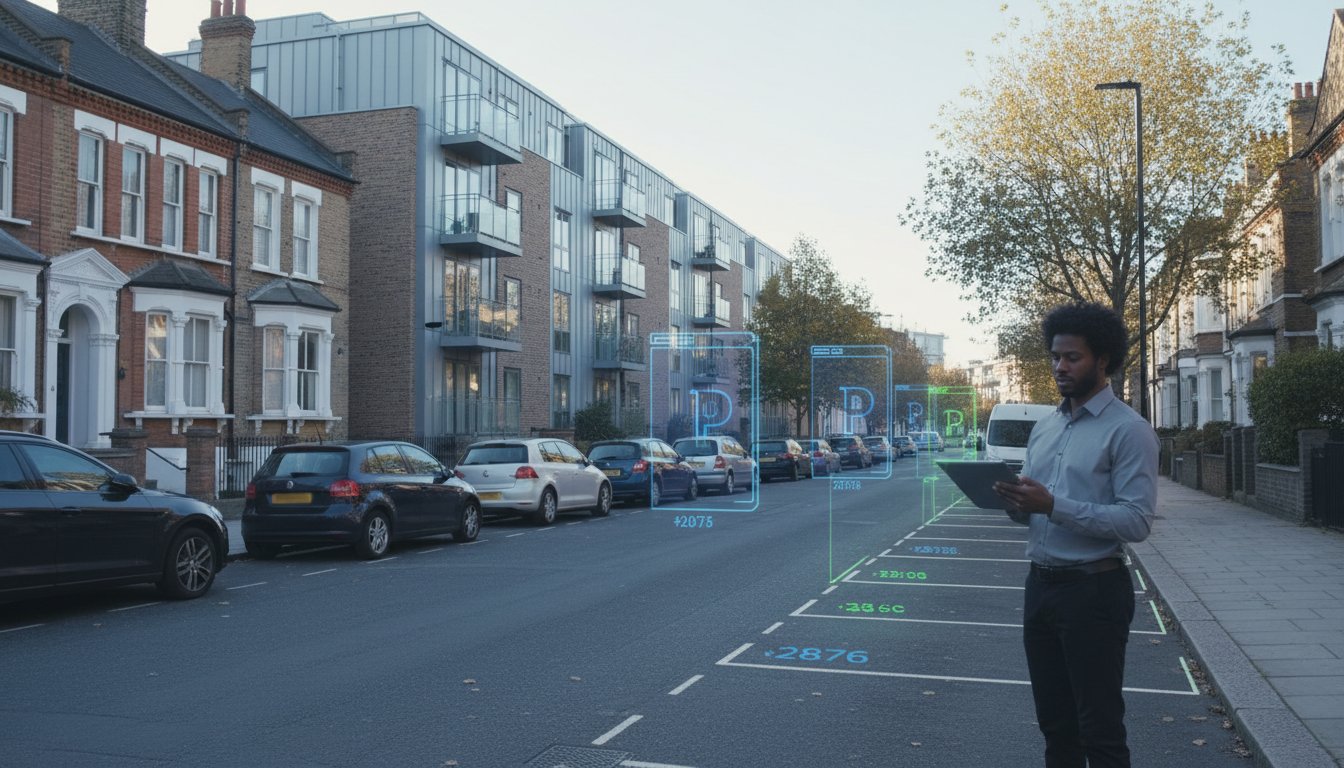
    Planning applications in the capital now face unprecedented scrutiny regarding air quality and vehicle emissions. Local Planning Authorities (LPAs) require developers to prove that london ulez construction logistics won’t compromise local air quality targets or breach legal limits. You must move beyond simple traffic counts. Modern submissions require a granular breakdown of vehicle Euro standards and fuel types. We use the latest TRICS database to model these movements, ensuring your forecast reflects the 2026 reality of ultra-low emission zones. This data informs your Transport Assessment London, turning a regulatory hurdle into a demonstration of ‘Good Design’ as defined by the London Plan 2021. Proactive planning prevents costly delays during the Section 106 negotiation phase.

    Transport Statements: More Than Just Traffic Counts

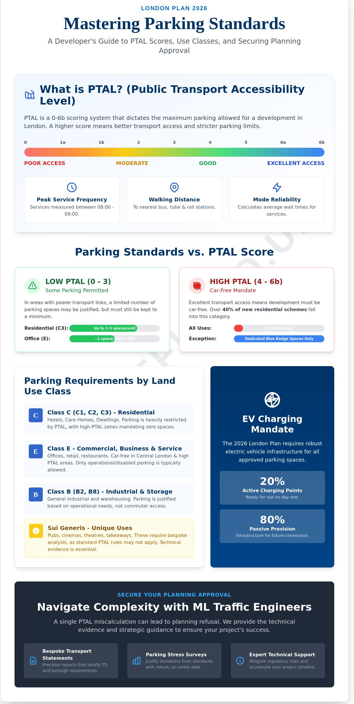
    A robust Transport Statement now hinges on a detailed delivery and servicing plan london that prioritises ULEZ-compliant fleets. It’s no longer enough to list total vehicle numbers; you must justify the fleet mix. If your strategy involves replacing one 32-tonne non-compliant HGV with several Euro 6 compliant vans to avoid the £100 daily charge, your statement must address the resulting increase in trip generation. We help you align these logistics with specific borough environmental targets. For instance, projects in Camden or Southwark must often demonstrate how they contribute to 2030 net-zero goals. Linking your vehicle justifications to these local policies increases the likelihood of a seamless approval process. Residential developers undertaking flat conversions in London should also ensure their transport statement addresses PTAL ratings and parking surveys to satisfy highways officers alongside these emission requirements. Similarly, developers working in south-east London should consult Transport Planning Consultants Lewisham specialists to navigate the borough’s unique parking standards and low PTAL constraints in areas like Deptford and Catford.

    The Role of Travel Plans in Reducing Construction Impact

    Construction worker transit significantly affects a project’s total emissions footprint. Effective London Travel Plans incentivise public transport use or car-pooling for site staff. This reduces the number of private vehicles entering the zone, lowering the risk of unexpected costs for your workforce. We implement monitoring systems to track compliance throughout the build phase, ensuring the project meets the vehicle reduction targets often required by planning conditions. London ulez construction projects that fail to monitor these movements risk enforcement action or negative post-occupancy evaluations. Our approach includes:

    • Drafting site-specific travel surveys to identify worker transit patterns.

    • Implementing digital booking systems for delivery slots to prevent idling.

    • Establishing clear reporting cycles to provide the LPA with evidence of ongoing compliance.

    • Providing 24/7 support to manage logistical shifts that impact the Travel Plan.

    By integrating these sustainable choices early, you protect the project from the financial volatility of non-compliance charges. It’s about creating a transparent, managed solution that satisfies both the developer’s bottom line and the city’s environmental standards.

    Strategic Logistics: Managing Site Access and Vehicle Scheduling

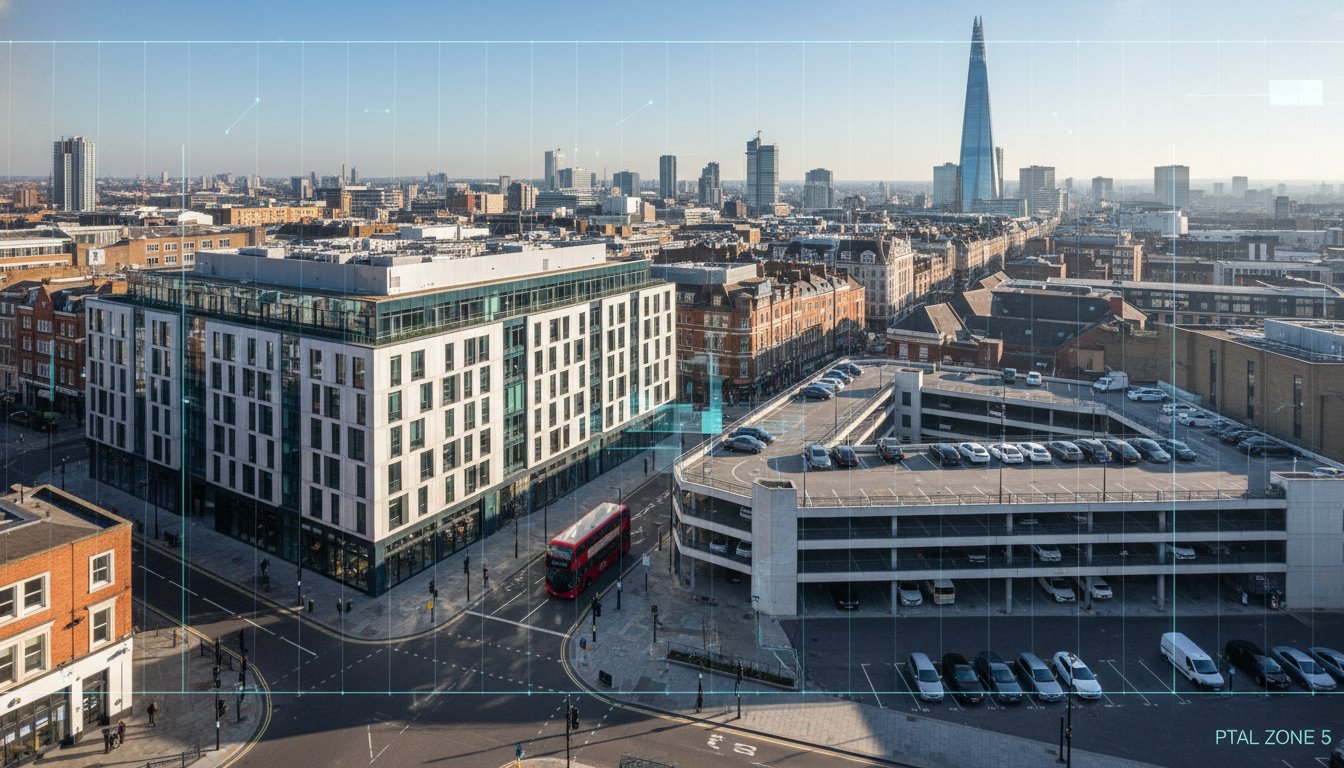
    Effective london ulez construction logistics require more than just checking engine types. Developers must rethink how vehicles physically interact with the site. Modern Euro VI HGVs often feature Direct Vision Standard (DVS) compliant cabs. Since the October 2024 DVS update, these low-entry designs have become the industry standard for London projects. However, these vehicles frequently result in different turning circles and longer wheelbases compared to the older, non-compliant trucks they replace. Precision in planning is a legal and physical necessity.

    Swept Path Analysis for Compliant Site Access

    Using CAD-based Swept Path Analysis (SPA) is now essential for securing planning approval. It proves that new-generation low-entry cabs can navigate tight urban streets without mounting kerbs or striking street furniture. We use technical CAD design to identify specific pinch points in the local road network that might hinder a compliant 32-tonne tipper. This is particularly vital in boroughs like Southwark or Tower Hamlets, where narrow Victorian layouts conflict with the increased length of DVS-rated chassis. Developers navigating the complex active travel requirements and PTAL constraints of east London sites should consult Transport Planning Consultants Tower Hamlets specialists to ensure their swept path and access strategies align with the borough’s 2026 planning expectations. Addressing these access design issues early prevents costly delays during the mobilisation phase. It ensures your 2026 fleet meets both ULEZ and DVS safety requirements without compromising site efficiency. A comprehensive road safety audit at this stage can also identify potential collision risks at site access points before they become costly late-stage design changes.

    Vehicle Scheduling and Fleet Management

    The financial logic of vehicle scheduling centres on the 24-hour ULEZ clock. Charges apply from midnight to midnight. A vehicle entering a site at 23:30 and exiting at 00:30 triggers two separate daily charges. For a fleet of ten HGVs, this oversight adds £1,250 to a single night’s operation. Implementing a strict "one-in, one-out" scheduling system minimises this exposure. We recommend integrating Auto Pay for all subcontractors. This removes the administrative burden and eliminates the risk of £180 Penalty Charge Notices (PCNs) for late payments. Data-driven logistics are the only way to maintain margins in 2026.

    • Consolidation Centres: Use fringe facilities to break down bulk loads into smaller, electric, or Euro VI compliant "last-mile" deliveries.

    • Traffic Surveys: Utilise traffic surveys to identify optimal delivery windows that avoid peak congestion and reduce idle time.

    • Compliance Audits: Conduct weekly checks on subcontractor plates to ensure no non-compliant vehicles enter the site perimeter.

    Our team provides a total managed solution to keep your project moving. If you need to secure your site access with technical precision, explore what we do to maintain full regulatory compliance.

    Expert Transport Consultancy for ULEZ-Compliant Developments

    Managing a london ulez construction project in 2026 requires more than just compliant vehicles. It demands a sophisticated understanding of how Greater London Authority (GLA) air quality targets interact with Section 106 agreements and Construction Logistics Plans (CLPs). ML Traffic Engineers operate at this exact intersection. We translate complex ULEZ policy into actionable site strategies that keep your project moving.

    Our team maintains 24/7 readiness to handle urgent site access issues and rapid transport planning revisions. When a delivery schedule shifts or a local authority denies a road closure, we respond immediately. We specialise in bespoke solutions for constrained urban sites where standard logistics fail. We move your project from the consultation phase to full implementation without regulatory friction. Our approach ensures that every vehicle movement is accounted for and every permit is secured.

    • Direct navigation of GLA and borough-specific planning requirements.

    • Rapid turnaround for amended traffic management drawings and CAD designs.

    • Strategic coordination of multi-way systems to minimise idling and emissions.

    • Total managed solutions that alleviate the administrative burden on site managers.

    Why Professional Reporting is Non-Negotiable

    Inadequate transport environmental data is a leading cause of planning refusal in Greater London. Local authorities now scrutinise every vehicle movement for its carbon and NOx impact. Our technical reports satisfy the rigorous standards of both TfL and individual borough highways departments. We recently resolved critical access conflicts for a major project involving various commercial and residential developments in Central London. By utilising precise CAD design and Chapter 8 compliant traffic management, we secured approval for a logistics hub that reduced local congestion by 12% during peak hours. Without professional reporting, these projects risk indefinite delays or costly enforcement actions.

    Partnering with ML Traffic Engineers

    Safety and legislative compliance form the foundation of our work. We don’t just supply equipment; we provide a total managed solution. You’ll have direct access to senior consultants who possess deep knowledge of the London planning landscape. This ensures your london ulez construction strategy remains robust against evolving 2026 standards. Our commitment to precision helps you avoid the £180 daily fines and potential site shutdowns associated with non-compliance. We act as a safe pair of hands, managing the intricate complexities of UK road regulations so you can focus on the build. Contact ML Traffic Engineers today to secure your project’s transport strategy and ensure seamless delivery for 2026.

    Future-Proofing Your 2026 London Developments

    Navigating the tightening standards for london ulez construction requires more than just updated vehicle fleets. Developers must integrate Euro VI compliance and Stage V Non-Road Mobile Machinery (NRMM) requirements into their initial transport assessments to avoid enforcement actions or site shutdowns. Success in the 2026 landscape depends on precise logistics and site access strategies that align with TfL’s latest planning frameworks. It’s essential to address these regulatory hurdles during the design phase to maintain project momentum and avoid the £160 daily non-compliance charges for HGVs. Commissioning a road safety audit in London during the design phase is an equally critical step to ensure your highway access arrangements satisfy GG 119 compliance requirements before submission.

    ML Traffic Engineers provides the technical authority needed to secure planning approvals across all 32 London Boroughs. We deliver specialist Swept Path Analysis using industry-standard CAD software to ensure your modern HGV fleet navigates tight urban sites safely and efficiently. Our team understands the intricate complexities of TfL requirements, providing a total managed solution that handles everything from transport planning to final implementation. We’re available 24/7 to ensure your site remains compliant and operational under the strictest environmental mandates. Developers targeting high-density sites in north London should also explore how Transport Planning Consultants Haringey can help address Haringey Council’s specific parking standards and Section 106 demands before submission.

    Ensure your London construction project is ULEZ-compliant with ML Traffic Engineers. We’re ready to help you deliver a safe, compliant, and successful development.

    Frequently Asked Questions

    Is my construction vehicle exempt from the London ULEZ charge?

    Your vehicle is only exempt if it meets Euro 6 (diesel) or Euro 4 (petrol) emissions standards. Specialist construction vehicles like mobile cranes or machinery may qualify for specific exemptions, but standard transit vans and HGVs generally don’t. You must check the TfL vehicle checker to confirm your status. Non-compliant vehicles must pay the daily charge or face a Penalty Charge Notice (PCN) of up to £180.

    What is the daily charge for a non-compliant van entering the ULEZ in 2026?

    The daily charge for a non-compliant van entering the London ULEZ remains £12.50 based on current TfL rates. This applies to most vans under 3.5 tonnes that fail to meet Euro 6 diesel standards. If you don’t pay by midnight on the third day following the journey, the PCN increases to £180. For heavier vehicles over 3.5 tonnes, the separate LEZ charge applies, which can reach £300 per day.

    How do I register my Non-Road Mobile Machinery (NRMM) for a London site?

    You must register all Non-Road Mobile Machinery (NRMM) with a power rating between 37kW and 560kW on the official NRMM London register. This is a mandatory requirement for all major development sites within Greater London. Ensure your equipment meets the Stage V emission standards required for the Central Activity Zone and Opportunity Areas. Failure to maintain an up-to-date log on the portal can lead to site-wide compliance breaches.

    Does the ULEZ charge apply if the vehicle is parked on-site all day?

    The ULEZ charge only triggers when you drive a non-compliant vehicle on public roads within the zone. If your vehicle remains stationary and parked on-site for the entire 24-hour period, you won’t incur a charge for that day. However, any movement on the public highway between 00:00 and 23:59 requires payment. We recommend planning deliveries to ensure non-compliant vehicles arrive and stay put to minimise costs.

    Can I pass ULEZ costs onto the client in a standard JCT contract?

    Passing london ulez construction costs to a client depends on your specific JCT contract terms. Under standard JCT forms, such as the Design and Build 2016 or 2024 editions, "Change in Law" clauses might allow for adjustments if regulations changed after the base date. However, since ULEZ is an established scheme, most contractors must account for these overheads within their initial tender price. Always review your Preliminary costs carefully.

    What happens if my subcontractor uses a non-compliant vehicle?

    The vehicle’s registered keeper is legally responsible for paying the ULEZ charge or any subsequent fines. However, as a lead developer, allowing non-compliant subcontractor vehicles can breach your Site Environmental Management Plan (SEMP). We provide comprehensive traffic management strategies that include vehicle monitoring to ensure all site traffic adheres to the required Euro VI standards. This protects your project from regulatory scrutiny and logistical delays.

    How does Swept Path Analysis relate to ULEZ compliance?

    Swept Path Analysis ensures that newer, often larger Euro VI compliant HGVs can safely navigate tight London site entrances without causing obstructions. By using CAD design to simulate vehicle movements, we prevent "dry runs" where non-compliant vehicles might be forced to enter the zone unnecessarily due to access issues. Efficient routing through london ulez construction zones reduces the number of required trips; this directly lowers your total daily charges.

    Are there grants available for upgrading construction fleets to Euro VI?

    Transport for London previously operated a £160 million scrappage scheme to support small businesses and charities. While many direct grants for vans closed in late 2023 after funds were allocated, you should monitor the TfL website for 2026 updates or sector-specific incentives. Some local boroughs offer independent "green" business grants. Upgrading to a compliant fleet avoids the £12.50 daily fee and ensures 24/7 access to all London boroughs.

    Which areas do you cover?

    We service Acton, Balham, Barking, Barnes, Barnet, Battersea, Beckenham, Bexleyheath, Brentford, Brixton, Bromley, Camberwell, Carshalton, Charlton, Chelsea, Chiswick, Clapham, Coulsdon, Croydon, Crystal Palace, Dagenham, Dulwich, Ealing, Edgware, Eltham, Enfield, Finchley, Forest Gate, Fulham, Golders Green, Greenwich, Hackney, Hammersmith, Hampstead, Harrow, Hayes, Highgate, Hounslow, Ilford, Islington, Kensington, Kentish Town, Kingston upon Thames, Lewisham, Mitcham, Muswell Hill, New Malden, Notting Hill, Orpington, Peckham, Pinner, Purley, Putney, Richmond, Romford, Ruislip, Sidcup, Southall, Southgate, Streatham, Surbiton, Sutton, Tooting, Tottenham, Twickenham, Uxbridge, Walthamstow, Wembley, West Norwood, Wimbledon, Wood Green, Woolwich, Bethnal Green, Shoreditch, Canary Wharf, Deptford, Leyton, Palmers Green, Stanmore, Upminster, Chislehurst, Erith, Feltham.

    Michael Lee

    Article by

    Michael Lee

    Transport planner with over 35 years' experience.

    Disclaimer

    The content on mltraffic.co.uk, including all technical articles, guides, and resources, is provided for general informational and educational purposes only. It is not intended to constitute professional advice in traffic engineering, transportation planning, development approvals, or any other technical or legal field.
    While ML Traffic Engineers makes every reasonable effort to ensure the accuracy, completeness, and timeliness of the information published, we do not provide any warranties or representations (express or implied) regarding its reliability, suitability, or availability for any particular purpose. Any reliance you place on the content is strictly at your own risk.
    In no event shall ML Traffic Engineers, its directors, employees, authors, or affiliates be liable for any direct, indirect, incidental, special, consequential, or punitive damages (including, without limitation, loss of profits, data, or business opportunities) arising out of or in connection with the use of, or inability to use, any information provided on this website.
    The articles and guides on this site are not a substitute for engaging a qualified, professional traffic engineer to assess your specific project requirements. For tailored advice, compliance assessments, or traffic engineering services, please contact a competent professional.
    This disclaimer may be updated from time to time without notice. By accessing or using this website, you agree to be bound by the most current version of this disclaimer.

  • Transport Planning Consultants Croydon: A Developer’s Guide to 2026 Approvals

    Transport Planning Consultants Croydon: A Developer’s Guide to 2026 Approvals

    How many Croydon residential schemes will stall in 2026 simply because a site access plan failed to meet the latest safety standards? You likely recognise that highway authority objections are the single biggest threat to your project timeline, frequently forcing expensive, late-stage redesigns that eat into your development margins. Securing planning permission in this borough requires more than just a basic layout; it demands technical precision from the outset. By engaging specialist transport planning consultants Croydon developers can transform these regulatory hurdles into a clear path for approval through rigorous CAD design and data-led strategy.

    We understand that confusion over PTAL ratings and parking minimums often creates unnecessary friction with local planners. This guide provides the expert insights you need to deliver a robust Transport Statement that stands up to council scrutiny. You’ll learn how to optimise your site layout for vehicle access and establish a seamless route toward S278 or S106 agreements. We’ll show you how technical excellence ensures your project moves from the initial planning phase to implementation without the typical delays that currently impact major London applications.

    Key Takeaways

    • Navigate the 2026 Croydon Local Plan updates with technical precision to ensure your development meets the latest regulatory benchmarks.

    • Identify the exact technical requirements for your site, using transport planning consultants Croydon to produce robust Transport Assessments and Travel Plans.

    • Solve complex site access hurdles using Swept Path Analysis to prove your design accommodates large vehicles on Croydon’s Victorian street networks.

    • Leverage advanced CAD design and TRICS database software to provide the data-driven evidence necessary for securing rapid planning permission.

    • Discover the critical criteria for selecting a technical partner with a proven track record of navigating the London Borough of Croydon’s planning process.

    Table of Contents

    Transport planning consultants Croydon act as the technical bridge between a developer’s vision and the London Borough of Croydon’s strict regulatory requirements. They don’t just draft reports; they manage the entire transportation planning process to ensure compliance with the Croydon Local Plan. Since the 2018 plan’s inception, and with the 2026 updates currently being integrated into planning policy, the scrutiny on new applications has intensified. Developers need a partner who understands how these policy shifts affect site viability and project timelines.

    To better understand this concept, watch this helpful video:

    Croydon’s geography dictates wildly different requirements for planning applications. A scheme in East Croydon, where Public Transport Accessibility Levels (PTAL) reach 6a or 6b, requires a different transport statement than a project in Purley. While East Croydon focuses on car-free residential units, Purley developments often must manage the logistical constraints of the A23. Early engagement with the council’s highway team is vital. It prevents expensive redesigns by identifying potential roadblocks before the formal submission. Our team provides comprehensive support to ensure your project meets every local safety and accessibility standard.

    Understanding Croydon’s Unique Transport Constraints

    Developers must navigate the "Sustainable Transport Corridor" requirements along the A23. This involves balancing high-density residential goals in PTAL 6 zones with the borough’s car-free aspirations. We provide bespoke solutions that address these constraints while protecting local commercial needs. Key constraints include:

    • Strict parking ratios in low PTAL areas like Coulsdon.

    • Cycle storage requirements that often exceed baseline London Plan minimums.

    • Complex delivery and servicing plans for constrained town centre sites.

    The Consequences of Poor Transport Planning

    Inadequate planning often leads to "holding objections" from Transport for London (TfL). These objections can delay a project by 180 days or more. Common reasons for refusal in South London include poor visibility splays and insufficient swept path analysis for emergency vehicles. A proactive approach saves time and ensures your project maintains its 2026 delivery schedule. We take pride in precision, ensuring every CAD design and multi-way system meets the highest safety standards. Our 24/7 readiness means we address regulatory queries immediately, keeping your consultation period on track. Using experienced transport planning consultants Croydon ensures that technical hurdles don’t become financial burdens.

    Essential Technical Reports for Croydon Developments: From Statements to Assessments

    Planning success in Croydon hinges on technical precision. As the borough intensifies its urban core, the requirements for highway impact evidence have become more stringent. Expert transport planning consultants Croydon provide the data-driven reports needed to satisfy the London Plan and local borough requirements. These documents serve as the legal and technical foundation for your planning application, ensuring that proposed developments don’t compromise road safety or network capacity.

    Transport Statements vs. Assessments

    Determining which report your project requires depends on the scale of the development and its projected trip generation. For smaller schemes, typically residential projects between 10 and 49 units or minor commercial builds, a Transport Statement is usually sufficient. This document focuses on local impact, site access, and parking provision. If your project exceeds 80 residential units or involves significant retail or industrial space, Croydon Council will demand a full Transport Assessment. This is a more rigorous document involving junction modelling and wider network impact studies. These reports must align with the professional standards set by the Chartered Institution of Highways & Transportation to maintain credibility during the consultation phase. For larger schemes, our guide on Transport Assessments outlines the specific modelling required for 2026 approvals.

    The Importance of Data-Driven Parking Surveys

    Parking is a primary flashpoint for Croydon planning committees. For urban infill projects, we utilise the Lambeth Methodology to conduct overnight parking stress tests. Our teams survey all available on-street spaces within a 200-metre walking distance of the site. This data is collected between 01:00 and 05:00 on two separate weekday nights to establish a baseline of parking demand. If you’re proposing a car-free development in a high PTAL (Public Transport Accessibility Level) area, these surveys are the only way to prove that any overspill won’t cripple local streets. We also ensure layouts meet the latest standards for disabled bays and electric vehicle (EV) charging infrastructure, which now requires a mix of active and passive provision to future-proof the site. Developers undertaking smaller residential conversions should also review the specific requirements for a flat conversions transport statement informed by PTAL ratings and parking surveys, as the same data-driven principles apply at every scale.

    Feasibility is further proven through Swept Path Analysis services. We use CAD-based simulations to demonstrate that refuse vehicles and fire tenders can safely enter and exit the site in a forward gear. This technical proof prevents costly design revisions later in the process. To mitigate environmental impacts, a Travel Plan is also integrated. This outlines specific measures to encourage cycling and walking, helping your project meet the borough’s sustainability targets. A comprehensive road safety audit is also a critical component of the technical evidence package, ensuring your access design meets GG 119 compliance standards before submission. For town centre and mixed-use schemes, a robust delivery and servicing plan london developers must submit alongside their Transport Assessment is increasingly scrutinised by TfL to ensure loading bay scheduling and vehicle swept paths meet 2026 Vision Zero standards. If you need to verify your site’s accessibility, we can provide comprehensive transport planning support to secure your 2026 approval.

    Transport Planning Consultants Croydon: A Developer’s Guide to 2026 Approvals

    Evaluating Transport Planning Consultants: Key Criteria for Croydon Projects

    Selecting the right transport planning consultants Croydon determines whether a project achieves planning consent or remains stuck in a cycle of council revisions. Developers must verify a consultant’s specific track record with the London Borough of Croydon (LBC). The council’s requirements for the Croydon Local Plan 2018, and the subsequent 2024 updates, are stringent. A consultant who has already successfully negotiated Highway Authority objections on the Purley Way or within the Croydon Opportunity Area brings a level of insight that generic firms lack.

    Technical proficiency is the foundation of any successful application. Your chosen partner must utilize the latest TRICS (Trip Rate Information Computer System) database software, ideally version 7.11 or newer, to provide accurate trip generation data. They should also demonstrate mastery of CAD design for swept path analysis. This ensures that refuse vehicles and emergency services can navigate your site safely, which is a primary concern for LBC planning officers.

    Operational readiness sets elite consultants apart from the competition. In the fast-moving construction sector, a delay of 48 hours can disrupt an entire supply chain. You need a consultant who operates with 24/7 readiness to address urgent queries from highways inspectors or site managers. They must provide a bespoke solution that prioritizes project ROI by streamlining traffic management layouts and reducing unnecessary hardware hire.

    The Difference Between Generalists and Specialists

    Large multi-disciplinary firms often treat transport planning as a secondary service, which leads to generic reports. These documents frequently miss the nuances of Croydon’s specific red route restrictions or residential parking permit zones. Independent specialists offer much faster turnaround times, often providing initial feasibility assessments within 5 to 10 working days. Always verify that the firm holds professional accreditation with the Chartered Institution of Highways and Transportation (CIHT) and maintains Professional Indemnity insurance of at least £5 million. Developers with sites across South London’s neighbouring boroughs should also consider how transport planning consultants in Lewisham approach similar Victorian street constraints and low PTAL challenges, as the technical strategies often overlap. Similarly, developers with sites in North London should explore how Transport Planning Consultants Haringey navigate high-density PTAL 6 zones and TfL objections, as the regulatory challenges mirror those faced across London boroughs. Developers with East London projects should also review how Transport Planning Consultants Tower Hamlets handle the borough’s active travel integration requirements and car-free development policies under the New Local Plan 2023–2038, as these approaches increasingly set the benchmark for high-PTAL zones across London.

    Cost vs. Value in Transport Consulting

    Fixed-price agreements offer the most security for developers, as they prevent fee creep during protracted negotiations with the Highway Authority. While a low-ball quote might seem attractive, it often results in "hidden" costs like additional charges for every minor revision or site visit. Expert reporting provides long-term value by potentially reducing Section 106 financial contributions by 15% to 20% through more accurate modeling of sustainable travel patterns. A high-quality Transport Assessment doesn’t just tick a box; it actively protects your profit margins by preventing expensive, over-engineered highway mitigation measures.

    Strategic Site Access and Parking: Overcoming Croydon-Specific Design Hurdles

    Croydon’s urban fabric presents a unique challenge for 2026 developments. Narrow Victorian street patterns, particularly in areas like South Croydon or Thornton Heath, often clash with modern vehicle dimensions. Developers must prove that their site layout can accommodate emergency services and waste collection without compromising public safety. Professional transport planning consultants Croydon use advanced CAD software to model these interactions before a single brick is laid. They ensure that new access points don’t create bottlenecks on already congested routes like the A23 or the A232.

    Transitioning from a private development to the public highway requires a Section 278 agreement. This legal mechanism ensures that any changes to the existing road network, such as new site access points or pavement widening, meet the local authority’s strict safety standards. In 2026, the focus on Vision Zero means that every junction must be scrutinised for pedestrian and cyclist safety. A formal road safety audit for your junction design is increasingly expected by Croydon’s Highway Authority to demonstrate GG 119 compliance before a Section 278 agreement can be finalised. The latest London Plan also mandates rigorous cycle parking quotas. For a typical residential scheme, you’ll need to provide one long-stay space per studio and two spaces for larger units. These must be accessible, secure, and integrated into the building’s ground floor footprint.

    Swept Path Analysis for Tight Urban Sites

    Swept Path Analysis is a mathematical guarantee of vehicle clearance. We use this digital simulation to track the exact movement of HGVs and fire tenders through restricted Croydon junctions. If a refuse vehicle cannot exit a site in a forward gear, the application will likely face a refusal from the council. Our team simulates precise entry and exit manoeuvres for residential car parks to ensure zero conflict with pedestrians or oncoming traffic. This technical precision removes guesswork from the design phase and provides the evidence required for a successful planning outcome. It’s a vital part of a managed solution that prioritises both site efficiency and road safety.

    Navigating PTAL and Car-Free Policies

    The Public Transport Accessibility Level (PTAL) rating of your site dictates your maximum parking allowance. In the Croydon Opportunity Area, where PTAL scores often reach 6a or 6b, the council expects car-free or car-capped developments. You must justify these restrictions by implementing effective Travel Plans to encourage sustainable transport. These documents outline specific measures, such as car club memberships or improved pedestrian wayfinding, to reduce reliance on private vehicles. Expert transport planning consultants Croydon will negotiate these parking ratios to ensure the development remains viable while meeting strict environmental targets. This strategic approach helps alleviate the regulatory burden on the developer. For those working on smaller residential projects, understanding how PTAL ratings and parking surveys shape transport statements for flat conversions provides essential context for managing parking overspill objections before they arise.

    Secure your site’s future by viewing our comprehensive transport planning services today.

    Securing Planning Success with ML Traffic Engineers in South London

    Success in Croydon’s evolving development landscape requires more than just standard paperwork. It demands a partner who understands the borough’s unique traffic patterns and the high expectations of the local planning authority. ML Traffic Engineers brings a wealth of experience across diverse project types, ranging from high-density residential blocks in the town centre to industrial expansions near the Purley Way. As leading transport planning consultants Croydon developers rely on, we bridge the gap between complex highway regulations and commercial viability.

    We combine technical authority with a customer-centric approach. We don’t just hand over a report; we advocate for your project. Our team translates intricate data into clear, actionable insights that satisfy council requirements while protecting your bottom line. Precision is a legal necessity in our industry. We treat every CAD design and multi-way system layout with the professional integrity your investment deserves. Our 24/7 readiness ensures that your project remains on track, regardless of the regulatory hurdles that may arise.

    A Safe Pair of Hands for Your Development

    Safety is the foundation of every successful planning application. We maintain strict Chapter 8 compliance across all our designs, ensuring that road safety is never compromised. Our process is logical and sequential. We move from the initial consultation through to final planning approval with clinical efficiency. We provide a total, managed solution for developers and architects. This means you won’t need to coordinate between multiple suppliers or worry about shifting legislative standards. We handle the technical complexities so you can focus on the build. Our specialists manage everything from temporary traffic signals to comprehensive site appraisals, ensuring seamless integration with existing South London infrastructure. For mixed-use and commercial developments, preparing a compliant delivery and servicing plan london authorities require is an essential step that our team integrates into the wider transport evidence package from the outset. For construction sites requiring heavy vehicle access, understanding London ULEZ construction compliance requirements is essential to avoid costly daily charges and planning delays.

    Get Started with Your Croydon Project

    The pace of construction in South London is relentless. Delays in transport planning can stall a project for months. We operate with a sense of urgency, offering 24/7 reliability to meet tight deadlines. You can access our online resources to understand the documentation required for 2026 approvals. If you have an urgent project review or need a site appraisal, our team is ready to act immediately. Choosing the right transport planning consultants Croydon offers is a strategic decision that impacts your project’s timeline and budget. Partner with specialists who view public safety and professional compliance as non-negotiable foundations. Contact us today for a comprehensive fee proposal and take the first step toward a successful planning outcome.

    Ensure Your Croydon Development Success for 2026

    Securing planning permission in Croydon by 2026 requires a proactive approach to technical compliance and site design. Developers must prioritise accurate Swept Path Analysis and comprehensive Parking Surveys to satisfy strict local authority requirements. Since 2014, ML Traffic Engineers has delivered over a decade of London-specific planning experience to ensure projects move from CAD design to final implementation without delay. Our team provides the precision needed for complex Transport Assessments and Statements; we manage every logistical detail to protect your investment.

    Choosing the right transport planning consultants Croydon makes the difference between a rejected application and a site ready for construction. We offer 24/7 availability to meet urgent planning deadlines, providing a reliable safety net for high-stakes developments. Our experts understand the intricate UK road regulations and Croydon-specific hurdles that often stall progress. We’re ready to handle the regulatory burden so you can focus on building.

    Secure your Croydon planning approval with expert transport advice from ML Traffic Engineers

    Let’s get your project approved and moving forward today.

    Frequently Asked Questions

    Do I need a transport planning consultant for a small Croydon development?

    Yes, you typically need professional input for any development creating new residential units or commercial floor space. Croydon Council requires a Transport Statement or a simplified Design and Access Statement for small-scale projects to ensure compliance with the 2018 Local Plan. Our transport planning consultants Croydon provide the technical data needed to prove your project won’t negatively impact local traffic flow or safety.

    What is the current PTAL rating for central Croydon and how does it affect parking?

    Central Croydon holds a PTAL rating of 6a or 6b, which represents the highest level of public transport accessibility. Under the London Plan 2021, developments in these high-score zones must be car-free, excluding required disabled person’s parking. This means you won’t be permitted to provide on-site parking for residents, and you’ll likely need to fund a Traffic Management Order to prevent occupants from obtaining local on-street permits.

    How long does it take to prepare a Transport Statement in London?

    A standard Transport Statement usually takes 2 to 4 weeks to complete from the initial site visit to the final report. This timeline depends on the availability of baseline traffic data and the complexity of your site’s access points. If your project requires bespoke traffic counts or specialized data from Transport for London, you should allow an additional 10 working days for data processing.

    Can a transport consultant help if the council has already objected to my access design?

    Yes, we can resolve council objections by using CAD design and Swept Path Analysis to demonstrate that your access point functions safely. We don’t just guess; we use industry-standard software to simulate vehicle movements for 12-metre refuse trucks and emergency services. This technical evidence often helps overcome safety concerns raised by the Highways Authority during the consultation phase.

    What is the Lambeth Methodology and is it required for Croydon parking surveys?

    The Lambeth Methodology is the industry-standard framework for conducting parking stress surveys, and Croydon Council mandates its use for most planning applications. It requires surveyors to record parking occupancy within a 200-metre walking distance of the site on two separate weekday nights between 00:30 and 05:30. These surveys prove whether there’s enough capacity on the street to absorb any "overspill" parking from your new development.

    How much does a Swept Path Analysis cost for a single site entrance?

    The cost of a Swept Path Analysis is determined by the number of vehicle types and specific maneuvers required by the local planning authority. While we don’t provide fixed estimates without seeing a site plan, these technical drawings represent a small fraction of the overall planning budget. They’re an essential investment that prevents costly delays or the total refusal of your application based on perceived access risks.

    What happens if Transport for London (TfL) gets involved in my planning application?

    TfL acts as a statutory consultee if your site is located on or near the Strategic Road Network or the Transport for London Road Network, such as the A23. They’ll scrutinise your Transport Assessment to ensure your project doesn’t hinder bus journey times or compromise pedestrian safety. Our transport planning consultants Croydon manage this high-level liaison to ensure your designs meet both borough and GLA-level requirements.

    How do I ensure my car park design meets Croydon’s 2026 safety standards?

    You must align your car park layout with the London Plan 2021 and the latest Building Regulations Part S. Every design must include a minimum of 20% active electric vehicle charging points from day one, with the remaining 80% having passive provision for future connection. We also integrate Vision Zero principles into your design to eliminate risks to vulnerable road users, which is a core requirement for 2026 approvals. Additionally, ensuring your construction logistics comply with London ULEZ construction standards will prevent unexpected charges and regulatory complications during the build phase.

    Which areas do you service?

    We are transport planners covering Addiscombe, Broad Green, Coulsdon, Kenley, New Addington, Norbury, Purley, Sanderstead, Selsdon, Shirley, South Croydon, South Norwood, Thornton Heath, Waddon, Woodside.

    Michael Lee

    Article by

    Michael Lee

    Transport planner with over 35 years' experience.

    Disclaimer

    The content on mltraffic.co.uk, including all technical articles, guides, and resources, is provided for general informational and educational purposes only. It is not intended to constitute professional advice in traffic engineering, transportation planning, development approvals, or any other technical or legal field.
    While ML Traffic Engineers makes every reasonable effort to ensure the accuracy, completeness, and timeliness of the information published, we do not provide any warranties or representations (express or implied) regarding its reliability, suitability, or availability for any particular purpose. Any reliance you place on the content is strictly at your own risk.
    In no event shall ML Traffic Engineers, its directors, employees, authors, or affiliates be liable for any direct, indirect, incidental, special, consequential, or punitive damages (including, without limitation, loss of profits, data, or business opportunities) arising out of or in connection with the use of, or inability to use, any information provided on this website.
    The articles and guides on this site are not a substitute for engaging a qualified, professional traffic engineer to assess your specific project requirements. For tailored advice, compliance assessments, or traffic engineering services, please contact a competent professional.
    This disclaimer may be updated from time to time without notice. By accessing or using this website, you agree to be bound by the most current version of this disclaimer.

  • Green Travel Plans in London: A Developer’s 2026 Implementation Guide

    Green Travel Plans in London: A Developer’s 2026 Implementation Guide

    Will a single inconsistency between Transport for London (TfL) requirements and borough-specific mandates derail your 2026 planning application? You already know that securing approval in the capital requires more than just a standard transport assessment. It demands robust green travel plans that satisfy conflicting regulatory bodies while remaining financially viable. Planning delays often stem from inadequate documentation, yet the cost of getting it wrong can exceed tens of thousands in lost project time.

    We’ve designed this guide to help you master these complexities and secure a safe pair of hands for your project’s logistics. You’ll gain a clear roadmap to planning approval, learn how to reduce site car-dependency by up to 20% based on recent London trends, and implement cost-effective transport strategies that satisfy every stakeholder. We’ll examine the technical requirements for 2026 and provide a sequential implementation strategy to keep your project compliant and moving forward without delay.

    Key Takeaways

    • Align your development with the latest London Plan 2021 and 2026 updates to ensure a seamless route to planning approval.
    • Master the technical requirements for developing robust green travel plans, including site audits and PTAL-based SMART targets.
    • Identify the essential ‘Hard’ and ‘Soft’ mitigation strategies needed to meet stringent cycle parking and sustainable transport standards.
    • Understand the long-term compliance obligations, from appointing a Travel Plan Co-ordinator to managing the Year 1, 3, and 5 monitoring cycles.
    • Learn why bespoke, borough-specific strategies are vital for navigating the complex regulatory landscape of London’s diverse planning authorities.

    Table of Contents

    What is a Green Travel Plan in the London Planning Context?

    A Green Travel Plan (GTP) is a package of bespoke measures designed to reduce single-occupancy car use and promote sustainable transport alternatives. It’s no longer a "nice-to-have" document; it’s a technical requirement for modern development. For developers, What is a Travel Plan? provides the foundational context, noting that while the industry often uses the term "Green Travel Plan," the UK planning system officially refers to it as a Travel Plan. These documents align development goals with the Mayor of London’s 80% sustainable mode share target for 2041.

    The evolution of green travel plans under the London Plan 2021 and the 2026 updates has shifted the focus from soft encouragement to hard enforcement. It’s about proving that a development won’t just "try" to reduce car use, but will actively achieve it through infrastructure and monitoring. We see a clear distinction between workplace plans focusing on staff commuting, residential plans targeting household shopping trips, and school plans prioritising safe, active routes for pupils. Each requires a different set of interventions, from cycle parking and car clubs to electric vehicle charging infrastructure.

    To better understand this concept, watch this helpful video:

    The Legal Framework: The London Plan and Local Borough Requirements

    The National Planning Policy Framework (NPPF) sets the baseline for transport decisions, but the London Plan adds layers of city-specific rigour. The 10 "Healthy Streets" indicators now drive GTP requirements, forcing developers to consider how their projects impact the public realm. Thresholds for green travel plans vary significantly across the capital. For instance, Barnet may trigger a full GTP requirement at a different density level than Lambeth. These local variations mean developers need precise, CAD-backed data to ensure compliance from the initial planning phase through to final implementation.

    Why a Green Travel Plan is Essential for Planning Permission

    How to Develop a Robust Green Travel Plan for Your Site

    Creating effective green travel plans requires a sequential, data-led approach. Developers must move beyond generic templates to deliver site-specific strategies that satisfy Transport for London (TfL) requirements and local borough mandates. The process follows five critical stages:

    • Step 1: Site Audit. Conduct an exhaustive assessment of existing transport links and PTAL ratings within a 960-metre radius for rail and 640-metre for bus.

    • Step 2: SMART Targets. Define clear goals for modal shift, such as a 15% reduction in single-occupancy car use within the first 60 months of occupation.

    • Step 3: Suite of Measures. Identify site-specific interventions like secure cycle storage, electric vehicle charging points, and car club memberships.

    • Step 4: Monitoring. Establish a review programme spanning 5 to 10 years to track progress against benchmarks using standardised survey methods.

    • Step 5: Formal Approval. Secure sign-off from the Local Highway Authority or TfL to ensure planning compliance and satisfy Section 106 obligations.

    Baseline Data Collection: Parking Surveys and PTAL Ratings

    Accurate parking surveys form the foundation of any GTP. These surveys identify current demand and prevent overspill into adjacent residential streets. Understanding Public Transport Accessibility Levels (PTAL) is equally vital. A site with a PTAL of 6b allows for car-free developments, whereas a PTAL 2 location requires more intensive mitigation measures. Developers should use the TRICS database to predict trip generation for their specific land use, ensuring the plan reflects realistic traffic volumes.

    Setting SMART Targets for Sustainable Modal Shift

    Goals must be Specific, Measurable, Achievable, Relevant, and Time-bound. By 2026, London developers must align their targets with the Mayor’s Transport Strategy, which aims for 80% of all trips to be made by foot, cycle, or public transport by 2041. Targets must be ambitious yet grounded in the site’s PTAL reality. If a development fails to meet these shifts, the local authority may trigger financial penalties or require additional mitigation measures. Our team provides comprehensive support for developers seeking to navigate these regulatory requirements with precision.

    A well-structured plan doesn’t just tick a compliance box; it enhances the long-term viability of the development. By integrating these five steps early in the design phase, you reduce the risk of costly retrofits or planning delays. Precision in the initial data collection phase ensures that the final green travel plans are both defensible during the planning committee and functional once the site is operational.

    Green Travel Plans in London: A Developer’s 2026 Implementation Guide

    Key Components and Sustainable Mitigation Strategies

    Effective green travel plans categorise interventions into ‘Hard’ infrastructure and ‘Soft’ behavioural measures. Developers must integrate both to meet the modal shift targets set by Transport for London (TfL) and individual boroughs. Precision in the planning stage ensures these strategies remain compliant with the London Plan 2021 and its 2026 iterations, which demand a prioritisation of active travel over private car use. You’ll find that a balanced approach reduces the need for costly highway capacity increases while satisfying local planning authorities.

    Infrastructure Measures: Cycle Parking and EV Charging

    The London Plan 2021, enforced through to 2026, mandates strict cycle storage ratios that developers cannot ignore. For residential developments, you must provide 1 space per studio or 1-bedroom unit, and 2 spaces for all other dwellings. These long-stay stores must be secure, covered, and integrated into the building fabric to prevent theft and weather damage. Short-stay visitor parking should be located near main entrances, typically at a rate of 1 space per 40 units.

    Integrating EV charging and car club bays requires careful spatial planning. Current regulations require 20% of parking spaces to have active charging facilities from the point of completion, with the remaining 80% featuring passive provision for future connection. You’ll need swept path analysis to prove that car club vehicles and maintenance vans can navigate the site layout without compromising pedestrian safety or obstructing the public highway. Designing for active travel means creating wide, well-lit pathways that make walking and cycling the most natural and efficient choices for residents.

    Soft Measures: Incentives, Car Clubs, and Information

    Marketing and communication form the backbone of behavioural change. Travel Information Packs (TIPs) are now a standard planning condition in London. These packs must be bespoke to the site and include:

    • High-quality local walking and cycling maps showing safe routes to nearby hubs.

    • Timetables and route maps for local bus, Tube, and rail services.

    • Details of Workplace Travel Plans, including Cycle to Work schemes and the location of on-site shower facilities for staff.

    • Vouchers for cycle training or discounts at local bike shops.

    Implementation and Monitoring: Ensuring Long-Term Compliance

    Successful green travel plans aren’t static documents that sit on a shelf after planning approval. They’re active commitments that require rigorous oversight to meet London’s 2026 sustainability targets. Local authorities demand proof that the proposed modal shift from private cars to sustainable transport is actually happening. This phase shifts the focus from theoretical planning to operational reality, where precision and data accuracy become the primary metrics of success.

    The Role of the Travel Plan Co-ordinator (TPC)

    Appointing a qualified TPC is a mandatory legal condition for most major London developments. This individual serves as the bridge between the developer, the residents, and the Borough’s Transport Officer. They don’t just distribute bus timetables; they manage the entire lifecycle of the plan. The TPC’s duties include resident engagement, managing car club memberships, and coordinating annual reporting. Many developers choose to outsource these technical duties to transport consultants to ensure that every regulatory milestone is met without delay. Professional TPCs provide the technical authority needed to manage complex data sets and maintain 24/7 readiness for council audits.

    Annual Monitoring Reports and Section 106 Obligations

    Compliance is measured through a strict monitoring cycle, typically occurring in years 1, 3, and 5 post-occupation. These surveys must be standardised and often require iTRACE or TRICS-compliant methodologies to ensure the data is robust. You’ll need to collect specific information on how people arrive at the site, including walking, cycling, and public transport usage. Once the data is gathered, it’s compiled into a Monitoring Report and submitted to the local authority for review. Failure to monitor can lead to enforcement action under the Town and Country Planning Act.

    If your development fails to meet its modal shift targets, the Section 106 agreement often triggers "remedial measures." This might include:

    • Additional financial contributions to local bus services.

    • Enhanced cycle training programmes for residents.

    • Increased investment in on-site infrastructure like secure bike storage.

    • Financial penalties if targets are missed by a specific percentage, often defined in the original planning consent.

    Staying ahead of these requirements prevents costly legal disputes and protects the development’s reputation. It’s about maintaining a safe pair of hands throughout the project’s life. We understand the intricate complexities of UK road regulations and planning obligations so you don’t have to worry about compliance gaps.

    Ensure your development meets every regulatory hurdle by partnering with experts who prioritise precision. Contact ML Traffic for comprehensive support with your travel plan implementation.

    London’s 33 local authorities operate with distinct priorities, making a generic approach to green travel plans a recipe for planning delays. Developers often face friction when a strategy that succeeded in Havering fails to meet the stringent requirements of Camden or Islington. ML Traffic Engineers specialise in bridging this gap. We translate complex developer ambitions into technical documents that Local Highway Authorities trust. Our team has extensive experience across diverse project types, ranging from high-density residential towers to complex mixed-use commercial developments. We understand that a site’s success depends on precision and an intimate knowledge of local street hierarchies.

    Our engineers act as a safe pair of hands throughout the consultation process. We don’t just submit reports; we defend them. By using data-driven insights, we justify sustainable travel choices that align with the Mayor’s Transport Strategy. This technical authority reduces the need for multiple revisions, often accelerating the approval timeline by several weeks. We remain available 24/7 to address urgent queries from planning officers, ensuring your project remains on schedule regardless of the regulatory hurdles.

    Tailoring Plans to Specific Borough Requirements

    Thresholds for mandatory GTPs vary significantly across the capital. In Inner London boroughs like Southwark, developers often trigger full travel plan requirements at lower unit counts compared to Outer London counterparts. The City of London requires specific focus on freight consolidation and pedestrian comfort levels that differ from the suburban requirements of Bromley. We ensure your travel plans are bespoke to the local street network. This involves analysing local cycle quietways, existing bus capacity, and specific borough targets for car-free housing. For developments in west London, working with specialist Transport Planning Consultants Hammersmith and Fulham is essential to navigate the borough’s Vision Zero safety standards and car-free policies. We focus on Chapter 8 compliance and safety standards to ensure every proposed measure is physically and legally viable.

    Why Expert Technical Analysis Secures Planning Success

    Standalone documents rarely suffice in the 2026 planning environment. We achieve the best results by integrating green travel plans with comprehensive transport assessments. ML Traffic Engineers utilise CAD design and advanced traffic modelling to prove that sustainable travel targets are achievable. We use real-time data to justify cycle parking ratios and electric vehicle charging infrastructure. This level of detail provides the certainty that Highway Authorities demand. Don’t leave your site’s accessibility to chance. Contact our team today to organise a professional consultation and secure a robust transport strategy that guarantees compliance and project momentum.

    Future-Proof Your London Development for 2026

    Success in the London planning landscape requires a rigorous commitment to the London Plan 2021 and TfL’s Healthy Streets approach. Navigating these requirements means moving beyond basic compliance to deliver green travel plans that offer genuine sustainable mitigation. Your site must demonstrate measurable shifts toward active travel to meet the 80% sustainable mode share target set for 2041. Precision in data collection and long-term monitoring remains the only way to avoid costly delays or enforcement action.

    ML Traffic Engineers provides the technical authority required to secure your project’s future. We offer expert knowledge across all 32 London Boroughs and the City of London. Our team remains available 24/7 for urgent technical planning support. We ensure every bespoke solution aligns with the latest Chapter 8 standards and London Plan mandates. We manage the entire process from initial CAD design through to final implementation. Secure your London planning approval with a professional Green Travel Plan from ML Traffic Engineers. We’re ready to help you navigate the complexities of UK road regulations with total confidence.

    Frequently Asked Questions

    Is a Green Travel Plan a legal requirement for all London developments?

    A Green Travel Plan is a legal requirement for all major developments as defined by the London Plan 2021. This includes residential projects with 80 or more units and commercial spaces exceeding 2,500 square metres. Local Planning Authorities enforce these requirements via Section 106 agreements to ensure compliance with Transport for London sustainability targets. Smaller sites often require a simplified travel statement if the local borough identifies specific transport pressures or environmental concerns.

    What is the difference between a Framework Travel Plan and a Full Travel Plan?

    A Framework Travel Plan applies to outline planning applications where final occupiers aren’t yet known. It sets broad modal shift targets and overarching strategies for the site. A Full Travel Plan is required for detailed applications or once a building is occupied. It includes specific measures tailored to the actual site users’ needs. Switching from a framework to a full plan typically occurs within six months of site occupation to reflect real-world travel data.

    How much does it cost to monitor a Green Travel Plan in London?

    Monitoring fees for green travel plans in London typically range from £3,000 to £15,000 over a five-year period. These costs are paid to the local council to cover the administration and review of annual monitoring reports. For example, some boroughs charge a flat fee per unit or a fixed sum based on the development’s total floor area. Developers must budget for these mandatory statutory fees as part of their initial Section 106 financial obligations.

    Can a Green Travel Plan help reduce the number of parking spaces required on-site?

    Yes, a robust Travel Plan can justify a significant reduction in on-site parking provision. In areas with high Public Transport Accessibility Levels (PTAL) of 4 to 6, the London Plan 2021 mandates car-free developments. By demonstrating viable alternatives like cycle hubs and car clubs, developers can satisfy planners that minimal parking is necessary. This approach maximises buildable space while meeting the Mayor’s target for 80% of trips to be sustainable by 2041.

    Who is responsible for implementing the Green Travel Plan measures?

    The developer holds initial responsibility for the plan’s creation and approval during the planning phase. Once the site is operational, a designated Travel Plan Coordinator (TPC) manages day-to-day implementation. The TPC role is a standard condition of the Section 106 agreement. They oversee data collection, promote sustainable transport initiatives, and act as the primary liaison between the development and the local borough’s transport officers to ensure ongoing compliance and safety.

    What happens if a development fails to meet its modal shift targets?

    Failure to meet modal shift targets triggers a review process where the developer must implement remedial measures at their own expense. Many London boroughs require a financial bond or contingency fund as part of the legal agreement. If targets aren’t met by the year five milestone, the council can claim these funds to improve local sustainable transport infrastructure. Local authorities use these enforcement powers to ensure developments don’t increase local road congestion or pollution.

    How long does a Green Travel Plan remain in effect?

    What are the common triggers for a London Borough to request a Travel Plan?

    The primary trigger for a London Borough to request a Travel Plan is the scale of the development reaching major status under the Town and Country Planning Order. Other triggers include sites located in Air Quality Management Areas (AQMAs) or those expected to generate significant traffic in congested zones. Even if a project falls below the standard size thresholds, a borough might request a plan if the local road network is at capacity or safety risks exist.

    Which areas do you cover?

    We service Acton, Balham, Barking, Barnes, Barnet, Battersea, Beckenham, Bexleyheath, Brentford, Brixton, Bromley, Camberwell, Carshalton, Charlton, Chelsea, Chiswick, Clapham, Coulsdon, Croydon, Crystal Palace, Dagenham, Dulwich, Ealing, Edgware, Eltham, Enfield, Finchley, Forest Gate, Fulham, Golders Green, Greenwich, Hackney, Hammersmith, Hampstead, Harrow, Hayes, Highgate, Hounslow, Ilford, Islington, Kensington, Kentish Town, Kingston upon Thames, Lewisham, Mitcham, Muswell Hill, New Malden, Notting Hill, Orpington, Peckham, Pinner, Purley, Putney, Richmond, Romford, Ruislip, Sidcup, Southall, Southgate, Streatham, Surbiton, Sutton, Tooting, Tottenham, Twickenham, Uxbridge, Walthamstow, Wembley, West Norwood, Wimbledon, Wood Green, Woolwich, Bethnal Green, Shoreditch, Canary Wharf, Deptford, Leyton, Palmers Green, Stanmore, Upminster, Chislehurst, Erith, Feltham.

    Michael Lee

    Article by

    Michael Lee

    Transport planner with over 35 years' experience.

    Disclaimer

    The content on mltraffic.co.uk, including all technical articles, guides, and resources, is provided for general informational and educational purposes only. It is not intended to constitute professional advice in traffic engineering, transportation planning, development approvals, or any other technical or legal field.
    While ML Traffic Engineers makes every reasonable effort to ensure the accuracy, completeness, and timeliness of the information published, we do not provide any warranties or representations (express or implied) regarding its reliability, suitability, or availability for any particular purpose. Any reliance you place on the content is strictly at your own risk.
    In no event shall ML Traffic Engineers, its directors, employees, authors, or affiliates be liable for any direct, indirect, incidental, special, consequential, or punitive damages (including, without limitation, loss of profits, data, or business opportunities) arising out of or in connection with the use of, or inability to use, any information provided on this website.
    The articles and guides on this site are not a substitute for engaging a qualified, professional traffic engineer to assess your specific project requirements. For tailored advice, compliance assessments, or traffic engineering services, please contact a competent professional.
    This disclaimer may be updated from time to time without notice. By accessing or using this website, you agree to be bound by the most current version of this disclaimer.

  • Traffic Surveys in London: A Developer’s Guide to Planning Data in 2026

    Traffic Surveys in London: A Developer’s Guide to Planning Data in 2026

    In 2024, industry analysis showed that nearly 45% of transport assessments for major London developments faced significant delays because the underlying data failed to meet the specific requirements of individual boroughs. When you’re managing a high-stakes project, a single oversight in your traffic surveys can lead to an immediate rejection of your planning application. We understand that the pressure to deliver accurate data is immense, especially when managing the evolving 2026 TfL standards. You need a reliable partner to ensure your transport data is bulletproof from the initial submission.

    You’ve likely experienced the frustration of shifting regulatory goalposts and the high costs of re-doing surveys that don’t meet council scrutiny. This guide will help you master the complexities of London’s transport requirements to secure planning approval with precision. We’ll examine the essential survey types required for 2026 and provide a clear path to satisfying both local and regional authorities. From junction capacity modelling to pedestrian flow monitoring, you’ll learn how to build a robust evidence base that keeps your project on track.

    Key Takeaways

    • Align your development with the London Plan 2026 by understanding how precise transport data underpins successful planning applications.
    • Identify the specific types of traffic surveys required for your project to meet the unique demands of London’s diverse local authorities.
    • Leverage AI-driven analytics and advanced video technology to ensure your data meets the rigorous accuracy standards expected by transport planners.
    • Navigate the complexities of the 32 London boroughs through proactive pre-application consultations and tailored survey methodologies.
    • Transform raw data into compelling technical evidence for Transport Statements that facilitate a smoother path to planning approval.

    Table of Contents

    What Are Traffic Surveys and Why Are They Vital in London?

    Traffic surveys are the systematic collection and analysis of transport data used to quantify how vehicles, cyclists, and pedestrians move through a specific area. In the high-stakes environment of London development, these surveys provide the empirical foundation for every successful planning application. They move beyond simple observation, providing a technical snapshot of road capacity, speed, and volume that local authorities require before any ground is broken.

    The London Plan 2026 sets rigorous standards for sustainable growth, requiring developers to align their transport strategies with borough-level policies. Because London operates under unique constraints like the Ultra Low Emission Zone (ULEZ) and the Congestion Charge, standard national traffic models often fail to capture the reality of the capital’s streets. Precise data is the only way to prove a project won’t negatively impact the city’s complex infrastructure. Relying on outdated or generic data is a significant risk. In 2023, inaccurate transport data remained a leading cause for planning refusals and forced developers into expensive design revisions late in the project lifecycle.

    The Purpose of Data in the Planning Process

    Establishing a baseline for existing conditions is the first step in any development. You must understand how a busy London centre functions during peak hours before introducing new traffic. We utilise various traffic count methodologies to capture high-accuracy data on vehicle classifications and turning movements. This evidence is essential for predicting the future impact of a site on the local road network. It provides the technical justification needed for a Transport Assessment London, ensuring your proposal is seen as viable by planning officers.

    Statutory Requirements and London Authorities

    Transport for London (TfL) maintains strict oversight of the Strategic Road Network. They demand high-quality traffic surveys to ensure network fluidity isn’t compromised. Local highway authorities also rely on this data when negotiating Section 278 agreements, which govern any permanent changes to public roads. Beyond motor vehicles, modern applications must satisfy "Healthy Streets" indicators. This requires accurate counts of pedestrians and cyclists to demonstrate that a development encourages active travel and meets the safety standards required by the Greater London Authority. You can learn more about our comprehensive approach to data collection in our section on what we do for developers across the capital.

    Core Types of Traffic Surveys for London Developments

    London councils demand precise, high-resolution data before they consider a planning application. You can’t rely on guesswork when the GLA’s transport targets are so stringent. Developers must deploy specific traffic surveys that align with the scale of their project and the unique constraints of the local road network. These surveys don’t just count cars; they provide a legal and technical foundation for your Transport Assessment. They also work in tandem with parking surveys to provide a complete picture of site impact.

    Automatic Traffic Counts (ATC) and Link Flows

    ATC surveys provide the baseline volume and speed data for specific road sections. We use pneumatic tubes or radar sensors to capture data 24 hours a day. While a single day might suffice in rural areas, the London standard is a full 7-day survey. This 168-hour window captures the vital variance between weekday commuter peaks and weekend retail traffic. This data ensures your project adheres to road traffic data collection standards, providing the accuracy required for junction capacity modelling. Accuracy here is non-negotiable. It prevents costly delays during the Section 106 negotiation phase.

    Manual Classified Counts (MCC) and Junction Analysis

    MCCs offer the granular detail that automated systems can’t reach. We deploy trained observers or high-definition video mast systems to record every turning movement at key intersections. We classify vehicles into specific categories: cycles, buses, HGVs, and LGVs. This classification is vital for validating TRICS database assumptions. If your development sits near a red route or a sensitive residential junction, the MCC provides the evidence needed to prove your site won’t cause gridlock. It’s a direct, functional way to satisfy the Highways Authority.

    Pedestrian and Cyclist Surveys

    London’s planning policy now prioritises "Active Travel" over private car use. We conduct detailed pedestrian and cyclist surveys to support car-free development goals. Our teams analyse desire lines and crossing usage in high-density areas to ensure safe access. We also assess how your site interacts with existing cycle superhighways or Quietways. Capturing this multi-modal data is essential for modern London applications. It shows you’ve considered the safety of all road users, not just motorists. If you need clarity on which data points your local borough requires, our team offers comprehensive traffic solutions to streamline your application.

    Traffic Surveys in London: A Developer’s Guide to Planning Data in 2026

    Methodologies and Technology: Ensuring Data Precision

    The era of manual tally counters is over. Modern traffic surveys rely on high-precision digital tools to capture every movement on the road. We operate in a 24/7 environment. London traffic never truly sleeps. This requires a robust approach to data collection that can withstand the scrutiny of local planning authorities. Accuracy is the primary hallmark of a professional transport consultancy. It is the difference between a project being approved or stuck in a cycle of costly revisions.

    Video Analytics and AI Data Collection

    High-definition video monitoring is the gold standard for complex multi-way systems and busy urban junctions. These systems use AI-driven analytics to provide automated vehicle classification. They distinguish between HGVs, LGVs, cars, and cyclists with 98% accuracy. The primary advantage of video is the ability to re-audit. If a council officer disputes the results, we review the raw footage to verify every vehicle count. This transparency prevents project delays and ensures your traffic surveys are beyond reproach.

    Radar and Infrared Sensing

    On red routes and high-speed corridors, non-intrusive methods offer a safer and more durable alternative. We deploy radar and infrared sensors that maintain reliability in heavy rain or low-light environments. These sensors don’t require road fixings. This means they are less likely to suffer from mechanical failure compared to pneumatic ATC tubes. They provide consistent speed and volume data throughout the duration of the study. Your planning application should be based on facts, not estimates.

    Queue Length and Delay Studies

    We measure the current saturation levels of London junctions to identify bottlenecks. These issues could be exacerbated by new site traffic. This involves tracking queue lengths and average delays during peak hours. This data is essential for swept path analysis services. By identifying these issues early, we propose bespoke mitigation strategies. We keep your project moving forward by proving the network can handle the additional load.

    All our processes strictly comply with GDPR and privacy regulations in public spaces. We use advanced masking technology. Individual faces and number plates are never identifiable in the final data sets. This commitment to privacy and precision makes us a safe pair of hands. We navigate the complex UK planning landscape so you don’t have to. Our readiness to deploy at short notice ensures your project stays on schedule.

    Planning applications in the capital require a granular approach because the 32 London boroughs rarely share identical technical standards. A survey design that satisfies Camden might face immediate rejection in Croydon. Developers often face significant delays by assuming a generic survey will suffice. We recommend a formal pre-application consultation to define the exact scope of required traffic surveys before deploying equipment on-site. This proactive step prevents the submission of redundant data and ensures your project meets the specific expectations of local highways officers. For projects in South East London, working with experienced Transport Planning Consultants Bromley can be critical to navigating the borough’s specific parking and access standards with precision.

    Timing is everything in London. Data collected during school holidays, bank holidays, or even local half-terms is considered non-representative. Planning officers typically demand data from "neutral" months, specifically avoiding December, August, and late July. If your data includes these periods, it’s likely to be invalidated. This forces a costly re-survey that could push your project timeline back by 12 weeks or more. Our team monitors local school calendars across all boroughs to ensure your data collection window is legally and technically sound.

    The Lambeth Methodology and Parking Stress

    The Lambeth Methodology represents the industry standard for assessing parking stress in London. It requires surveyors to record parking occupancy between 00:30 and 05:30 on two separate weekday nights. This specific window captures peak residential demand when most residents have returned home. You must survey every publicly accessible road within a 200-metre walking distance of the site. If the survey identifies parking stress levels above 80%, the council may require significant changes to your proposal to mitigate the impact on local residents. We deliver these reports with high-precision CAD drawings to illustrate capacity clearly.

    PTAL Ratings and Accessibility Surveys

    Your site’s Public Transport Accessibility Level (PTAL) score dictates the intensity of your survey requirements. High PTAL zones, such as those with scores of 5, 6a, or 6b, often allow for car-free developments. However, these sites require robust travel plans to prove how occupants will move without private vehicles. Conversely, low PTAL areas might require "walk-interval" surveys. These studies measure the time and safety of pedestrian routes to the nearest bus stops or rail stations. We ensure these surveys account for pavement widths and crossing wait times to meet strict Transport for London (TfL) criteria.

    Ensure your project meets local standards by contacting our team for bespoke traffic survey solutions.

    From Raw Data to Planning Approval: The Final Report

    Raw data provides the foundation, but the final report delivers the result. ML Traffic Engineers transform raw counts into technical planning evidence that stands up to rigorous scrutiny from local authorities. We don’t just hand over spreadsheets; we provide a narrative that supports your development goals. This evidence populates the Transport Statements and Transport Assessments required for 95% of major planning applications in the UK. We use this data to justify specific design choices, such as car-park layouts and the positioning of access points. This ensures your site operates safely and efficiently from day one.

    Precision is a legal and physical necessity in this final stage. We cross-reference all traffic surveys against the latest TfL best practice guidance to ensure compliance. This meticulous approach alleviates the regulatory burden on your team. It means your application moves through the system without the delays caused by data queries or requests for resubmission. Working with experienced transport consultants UK developers rely on ensures that every technical report is prepared to the exacting standards required by both local authorities and Transport for London.

    Data Visualisation and Technical Reporting

    We create clear, CAD-ready datasets designed for immediate architectural integration. Our team summarises complex vehicle flows into digestible tables that planning officers can interpret quickly. This clarity is essential when explaining how a new junction will perform during peak hours. We focus on providing a total, managed solution that bridges the gap between raw numbers and site design. You can explore our resources for technical reporting standards that define our high-quality output.

    • Detailed junction capacity modelling using industry-standard software.

    • Visual flow diagrams that illustrate vehicle, pedestrian, and cyclist movements.

    • Bespoke reporting tailored to the specific requirements of your Local Planning Authority.

    Securing Your Planning Consent

    The final report is your primary tool for negotiation. We use the data to prove that a development won’t have a "severe" impact on the road network, a key threshold defined in paragraph 115 of the National Planning Policy Framework (NPPF). This evidence is vital when negotiating mitigated contributions under Section 106 agreements. By proving the actual impact is manageable, we often help clients avoid unnecessary and costly infrastructure levies.

    For developments within Greater London, we ensure every survey aligns with the TfL Healthy Streets indicators and 2024 data collection protocols. We act as a safe pair of hands, understanding UK road regulations so you don’t have to. Learn more about what we do to support London developers in securing consent through accurate, high-speed data delivery. Our 24/7 readiness ensures that even if a planning officer requests additional data at the last minute, we can respond with the urgency your project demands.

    Streamline Your 2026 Planning Application

    Securing planning approval in London requires a meticulous approach to data that satisfies the unique requirements of all 32 boroughs. You’ve seen how precise traffic surveys and advanced methodologies are essential to navigating these regulatory hurdles. Accurate data serves as your project’s foundation, ensuring that every transport assessment is robust enough to withstand scrutiny from local authorities. It’s about more than just numbers; it’s about providing a safe, compliant, and efficient roadmap for your development.

    ML Traffic Engineers offers over 10 years of London planning expertise to help you manage these complexities. With 24/7 data collection capability and a reputation for reliability across the capital, we provide the technical authority your project needs. We’ll manage the entire process from initial consultation to the final report, allowing you to maintain momentum without administrative delays. Our team is ready to deliver the bespoke, high-stakes data required for modern UK infrastructure projects.

    Contact ML Traffic Engineers for a Bespoke Survey Quote

    We look forward to helping you achieve a successful planning outcome for your next London development.

    Frequently Asked Questions

    How long does a typical traffic survey take to complete in London?

    A standard programme for traffic surveys involving Automatic Traffic Counts (ATCs) typically requires seven consecutive days of data collection. Once the site equipment is recovered, data processing and quality assurance checks take approximately three to five working days. This timeline ensures we capture a full weekly cycle, including weekend and weekday variations, to meet Transport for London (TfL) requirements.

    Can I use old traffic data for a new planning application in 2026?

    Local authorities generally reject traffic data that’s more than three years old. If you’re submitting a planning application in 2026, data collected before 2023 will likely be considered obsolete due to shifting post-pandemic travel patterns. We recommend commissioning fresh surveys to ensure your submission reflects current road usage and avoids costly delays during the validation stage.

    What happens if the traffic survey shows high levels of congestion?

    High congestion levels require the development of a robust mitigation strategy or a formal Travel Plan to reduce vehicle trips. You might need to propose infrastructure improvements, such as junction redesigns or Section 106 financial contributions for public transport. Most London boroughs look for a 10% to 15% reduction in peak-hour trips through these sustainable transport measures.

    Do I need a traffic survey for a small-scale residential development?

    You’ll likely need a survey if your project exceeds 10 residential units or is located near a sensitive or over-capacity junction. Even for smaller sites, a Transport Statement is often required to prove the development won’t compromise local road safety. We assess each site’s specific impact to determine if a full traffic surveys suite is necessary for your planning consent.

    How much do traffic surveys cost for a London project?

    Costs for London surveys depend on the number of observation points, the equipment required, and the duration of the study. A single-site Automatic Traffic Count using pneumatic tubes is less resource-intensive than a multi-junction manual turning count involving AI camera technology. We provide bespoke quotes based on your specific borough requirements to ensure you don’t overspend on unnecessary data collection.

    What is a "Neutral Week" and why is it required for London surveys?

    A neutral week is a period excluding school holidays, bank holidays, and seasonal events that might skew traffic data. These weeks typically occur in late spring and autumn, such as May or October. Using these windows is mandatory because it provides a representative baseline of normal traffic conditions, which is essential for accurate impact modelling.

    Is video monitoring allowed under London privacy laws?

    Video monitoring is fully legal provided it complies with the Data Protection Act 2018 and UK GDPR standards. We use high-definition cameras to track vehicle movements, but individual privacy is protected through data anonymisation. Faces and number plates are processed solely for statistical purposes, ensuring your project remains compliant with all UK surveillance regulations.

    How do I know which London borough methodology to follow?

    You must consult the specific Local Plan and Transport Assessment guidelines issued by your local council. While all 32 London boroughs follow the general TfL Transport Assessment Guidance (2014), individual authorities often have unique requirements for cycle parking or construction logistics. We coordinate directly with borough transport officers to ensure our methodology meets their exact technical specifications.

    Which areas do you cover?

    We service Acton, Balham, Barking, Barnes, Barnet, Battersea, Beckenham, Bexleyheath, Brentford, Brixton, Bromley, Camberwell, Carshalton, Charlton, Chelsea, Chiswick, Clapham, Coulsdon, Croydon, Crystal Palace, Dagenham, Dulwich, Ealing, Edgware, Eltham, Enfield, Finchley, Forest Gate, Fulham, Golders Green, Greenwich, Hackney, Hammersmith, Hampstead, Harrow, Hayes, Highgate, Hounslow, Ilford, Islington, Kensington, Kentish Town, Kingston upon Thames, Lewisham, Mitcham, Muswell Hill, New Malden, Notting Hill, Orpington, Peckham, Pinner, Purley, Putney, Richmond, Romford, Ruislip, Sidcup, Southall, Southgate, Streatham, Surbiton, Sutton, Tooting, Tottenham, Twickenham, Uxbridge, Walthamstow, Wembley, West Norwood, Wimbledon, Wood Green, Woolwich, Bethnal Green, Shoreditch, Canary Wharf, Deptford, Leyton, Palmers Green, Stanmore, Upminster, Chislehurst, Erith, Feltham.

    Michael Lee

    Article by

    Michael Lee

    Transport planner with over 35 years' experience.

    Disclaimer

    The content on mltraffic.co.uk, including all technical articles, guides, and resources, is provided for general informational and educational purposes only. It is not intended to constitute professional advice in traffic engineering, transportation planning, development approvals, or any other technical or legal field.
    While ML Traffic Engineers makes every reasonable effort to ensure the accuracy, completeness, and timeliness of the information published, we do not provide any warranties or representations (express or implied) regarding its reliability, suitability, or availability for any particular purpose. Any reliance you place on the content is strictly at your own risk.
    In no event shall ML Traffic Engineers, its directors, employees, authors, or affiliates be liable for any direct, indirect, incidental, special, consequential, or punitive damages (including, without limitation, loss of profits, data, or business opportunities) arising out of or in connection with the use of, or inability to use, any information provided on this website.
    The articles and guides on this site are not a substitute for engaging a qualified, professional traffic engineer to assess your specific project requirements. For tailored advice, compliance assessments, or traffic engineering services, please contact a competent professional.
    This disclaimer may be updated from time to time without notice. By accessing or using this website, you agree to be bound by the most current version of this disclaimer.

  • Lambeth Parking Survey Methodology: The 2026 Developer’s Guide to Planning Approval

    Lambeth Parking Survey Methodology: The 2026 Developer’s Guide to Planning Approval

    Your 2026 London development project could face an immediate planning refusal because of a single data error recorded at 02:00. Securing planning permission in Lambeth requires more than just a standard traffic count; it demands strict adherence to the lambeth parking survey methodology. We understand that the pressure to prove parking stress levels are manageable is immense, especially when a single mistake during the 01:00 to 05:30 observation window can invalidate your entire application.

    You’re likely concerned about the precision needed for 200-metre walking distance calculations or how to justify a car-free development to a sceptical Case Officer. It’s a common frustration for developers who want to keep their project on track. This guide provides the technical clarity you need to master these requirements and submit a compliant report. We’ll examine the exact data collection standards and show you how to leverage 24/7 expert monitoring to ensure your project moves from the planning phase to final implementation without a hitch.

    Key Takeaways

    • Understand why this technical framework is the industry-standard requirement for securing planning permission across London’s most competitive boroughs.

    • Master the mandatory survey parameters, including the strict 200-metre walking distance radius and the non-negotiable 01:00 to 05:30 observation window.

    • Learn how to apply the lambeth parking survey methodology to calculate parking stress and successfully navigate the critical 80% capacity threshold.

    • Identify borough-specific variations in Southwark, Wandsworth, and Lewisham to ensure your technical submission meets local regulatory expectations.

    • Discover why professional data collection is essential to provide the accuracy required to prevent planning refusals and costly project appeals.

    Table of Contents

    What is the Lambeth Parking Survey Methodology?

    The lambeth parking survey methodology represents the benchmark for quantifying on-street parking capacity across the capital. While originally developed by Lambeth Council, it has since become the industry-standard framework adopted by the majority of London boroughs. It functions as the primary evidence-based tool for developers to prove that a new project won’t cause unacceptable parking pressure on local residents. This rigorous assessment is a non-negotiable requirement for any project where the proposed parking provision falls below local authority standards. It ensures that the Technical aspects of urban planning are balanced with the practical realities of street-level infrastructure.

    For developers in 2026, precision is vital. Planning committees don’t accept guesswork. They demand empirical data. The methodology provides a clear, mathematical snapshot of how many cars are parked within a specific radius of a site. It’s the foundation of a successful planning application, especially for high-density residential schemes. Without this data, your project risks immediate rejection on the grounds of transport impact. We provide the technical expertise to ensure your survey meets these exacting standards from the first day.

    To better understand the practical side of parking management in the borough, watch this helpful video from Lambeth Council:

    The Core Purpose of the Survey

    The methodology’s main goal is to establish a baseline of existing parking demand during peak residential times. This usually involves two separate counts between 12:30 am and 5:30 am on weekday nights. These specific hours capture the maximum number of residents at home. The data provides the empirical evidence needed to support car-free or car-capped developments. It directly satisfies the requirements of the National Planning Policy Framework (NPPF), which states that development should only be refused on highways grounds if there’s an unacceptable impact on safety or a residual cumulative impact. By using the lambeth parking survey methodology, you provide the clear evidence needed to mitigate these concerns.

    Why ‘Lambeth’ is the London Standard

    Consistency across different local authorities is the main reason this methodology dominates the market. It prevents methodology hopping, where developers might try to use less rigorous standards to hide parking issues. For Planning Committees, it offers a transparent and repeatable metric that they can trust. This level of standardisation simplifies the approval process. The survey results integrate naturally with Transport Statements and Assessments, forming a cohesive argument for your site’s viability. It’s a reliable system that allows us to manage your project’s regulatory burdens with total precision.

    The Technical Framework: Radius, Timing, and Capacity

    Precision is the foundation of the lambeth parking survey methodology. It’s not a simple tally of vehicles; it’s a rigorous technical assessment where accuracy determines the success of a planning application. Developers must provide a granular view of local parking stress to satisfy Council requirements and avoid costly delays. This starts with a clear understanding of the spatial and temporal boundaries that define the survey’s scope.

    Mapping the 200m Survey Area

    The survey doesn’t use a simple radial "as the crow flies" circle. Instead, it requires a true 200-metre walking distance route from the site entrance. Our team utilizes 1:1250 scale OS mapping to identify every available centimetre of kerbside space within this walkable network. We account for physical obstructions that reduce capacity, including fire hydrants, private driveways, and dropped kerbs. This level of detail is critical because the Planning Inspectorate Appeal Decision has demonstrated that even minor inaccuracies in survey boundaries can undermine a developer’s transport statement. We exclude areas where parking is prohibited, such as double yellow lines or within 10 metres of a junction, to ensure the data reflects legal, safe parking only.

    Standardising the Survey Times

    Data collection must occur during the period of maximum residential parking demand. The non-negotiable window is 01:00 to 05:30. Surveys are conducted on two separate weekday nights, typically a Tuesday and a Wednesday, to provide a representative average of typical parking stress. We strictly avoid anomalous dates. This includes bank holidays, school half-terms, or nights where major local events at venues like the Brixton Academy might skew the results. Our safety-conscious data collectors work through these 24/7 environments in high-visibility gear, capturing snapshots of every parked vehicle to calculate exact occupancy rates. This high-stakes environment demands the unwavering reliability that our field teams provide.

    Calculating Theoretical Capacity

    On unmarked roads, we apply the 5-metre rule. This standard dictates that each 5-metre length of clear kerbside constitutes one parking space. We then cross-reference this against Controlled Parking Zones (CPZs) and specific permit restrictions to determine the true capacity available to residents. For developments with tight access points, we often pair these surveys with Swept Path Analysis services to prove that increased parking occupancy won’t compromise emergency vehicle access or general highway safety. If you’re preparing a submission for a high-density project, our team offers comprehensive support to ensure your data meets the 2026 standard for planning approval.

    Lambeth Parking Survey Methodology: The 2026 Developer’s Guide to Planning Approval

    Calculating Parking Stress and Impact on Planning

    Accurate data interpretation is the backbone of any successful planning application in South London. Under the lambeth parking survey methodology, parking stress is defined as the percentage of kerbside capacity occupied by vehicles at peak times. This figure determines whether your project adds unacceptable pressure to local infrastructure or remains within sustainable limits.

    The calculation is straightforward but requires precise inputs: (Parked Vehicles / Total Capacity) x 100. For instance, if a survey area contains 100 available spaces and 82 vehicles are recorded during the 00:30 to 05:30 window, the parking stress is 82%. Case Officers view the 80% threshold as a critical tipping point. Once occupancy exceeds this level, finding a parking space becomes difficult for residents, often leading to illegal parking or increased congestion. If your survey results sit consistently above 80%, you must prepare a robust justification for your development’s impact.

    A professional technical report must also account for the cumulative impact of other nearby developments. Lambeth Council requires developers to consider committed developments within a 200-metre radius that haven’t been built yet but already have planning permission. Ignoring these future residents can lead to your survey being rejected during the consultation phase because the baseline data fails to reflect the reality of the street’s future capacity.

    Interpreting the Stress Levels

    When stress levels exceed 85% or 90%, the risk of application refusal increases significantly. In these high-stress areas, you can’t simply present the numbers; you must provide mitigation. This often involves permit-free legal agreements, preventing new residents from applying for on-street permits. You might also propose financial contributions to local sustainable transport initiatives or provide on-site car club bays to offset demand. Showing this proactive approach reassures the council that you’ve considered the wider community impact.

    Data Integrity and Transparency

    Transparency is non-negotiable for 2026 planning approvals. ML Traffic provides audit-ready data by including raw data sheets and time-stamped photographs for every street segment surveyed. This level of detail allows council officers to verify results quickly, reducing the likelihood of costly delays or requests for re-surveys. We ensure every lambeth parking survey methodology report is backed by empirical evidence that stands up to scrutiny.

    Linking these survey results to London Travel Plans is a strategic move to reduce car dependency. By showing a clear path toward cycling and public transport use, you demonstrate a commitment to Lambeth’s long-term environmental goals. Our team manages this entire process, moving from initial data collection to final report implementation with speed and technical authority.

    Common Pitfalls and Borough-Specific Variations

    Attempting a "DIY" survey is the fastest route to a planning refusal. Local planning authorities require data that is both objective and legally defensible. If your data fails to align with the lambeth parking survey methodology, your application will be deferred or rejected without hesitation. Precision is a legal requirement in the 2026 planning environment. Council officers quickly identify amateur data sets that lack the necessary technical rigour.

    Why Local Authorities Reject Surveys

    Inaccurate mapping of physical restrictions causes immediate failure. If a surveyor misses a 5-metre stretch of double yellow lines or fails to account for a suspended bay, the entire capacity calculation becomes void. We have seen applications rejected because surveys occurred during rail strikes or school holidays when parking demand drops by as much as 20%. The methodology section of your final report must be transparent. It needs to detail exact timings, weather conditions, and any observations of unusual activity that might skew the results. Failure to provide this level of detail suggests a lack of professional oversight.

    Adapting the Methodology Across London

    While Lambeth follows a specific framework, neighbouring boroughs have distinct nuances that developers often overlook. Wandsworth frequently demands weekend surveys for residential developments to capture peak overnight demand that weekday data might miss. Southwark and Lewisham often require additional scrutiny for sites with high PTAL ratings, typically 5 or 6, to ensure car-free developments don’t overwhelm local infrastructure. Consulting with London transport planning experts ensures these site-specific requirements are integrated into the survey design from the start.

    Ignoring seasonal variations is another critical error. Parking pressure in December differs significantly from July. If you conduct a survey during a period of untypical behaviour, such as a major local event or emergency roadworks, the council will identify the anomaly. We cross-reference all survey data with long-term local trends to ensure your 2026 planning submission stands up to the most rigorous council scrutiny. This proactive approach eliminates the need for expensive re-surveys and prevents project delays. Our team identifies these risks before the first surveyor arrives on-site, providing a safe pair of hands for your project’s logistics.

    To ensure your project meets every regulatory requirement, secure your 2026 planning approval with a professionally managed parking survey today.

    Why Professional Execution is Non-Negotiable for Approval

    Lambeth’s 2026 planning landscape leaves zero room for data discrepancies. A single miscounted "beat" or an incorrectly identified parking permit zone (CPZ) can trigger a formal objection from the Highways Department. This often results in a planning appeal, a process that adds an average of 32 weeks to your project timeline and can cost upwards of £12,000 in additional consultancy and legal fees. Precision isn’t just a preference; it’s a financial necessity.

    Utilising a robust lambeth parking survey methodology ensures your data withstands the scrutiny of planning officers. We treat every survey as a legal document. Our data provides the empirical foundation for your planning application, ensuring that claims about local parking capacity are backed by verifiable, timestamped evidence. This data doesn’t exist in a vacuum. It’s a critical component that must be seamlessly integrated into your Transport Assessment to provide a holistic view of the development’s impact.

    Choosing a "safe pair of hands" means you aren’t just buying data; you’re buying regulatory compliance. We understand the intricate nuances of Lambeth’s specific requirements, such as the 200-metre walking distance rule and the exclusion of dangerous junctions from capacity totals. We handle the technical complexities so you can focus on the build.

    The ML Traffic Advantage

    We operate on a 24/7 basis because planning deadlines don’t stick to standard office hours. Our team is ready for emergency and time-sensitive surveys, often deploying staff within 48 hours of instruction. We provide bespoke reporting that speaks the direct language of London Planning Officers, using the specific terminology and data visualisations they expect to see. Our total managed solution covers everything from the initial beat planning to the final report delivery, removing the logistical burden from your project managers.

    Securing Your Planning Quote

    To provide an accurate, fixed-fee quote for your project, our team requires three key pieces of information: the site location, the proposed unit count, and your target submission timeline. We don’t cut corners on safety or quality. Every survey we conduct is fully Chapter 8 compliant, protecting both our workers and the public while ensuring the integrity of the data collected. We’ve maintained a 98% first-time acceptance rate for our reports in 2025, and we’re committed to carrying that standard into 2026.

    Ready to move forward with your application? Contact ML Traffic for a Lambeth Parking Survey Quote today to ensure your project stays on track.

    Secure Your 2026 Planning Approval with Precision Data

    Navigating the lambeth parking survey methodology requires strict adherence to Lambeth Council standards, including the mandatory 200-metre radius rule and specific 1:00 AM to 5:00 AM survey windows. Precision is non-negotiable for developers; even a 2% discrepancy in parking stress calculations can trigger an immediate planning refusal. Your transport assessment must accurately reflect existing CPZ restrictions and overnight capacity to withstand rigorous council scrutiny during the 2026 planning cycle.

    ML Traffic provides the technical authority needed to clear these regulatory hurdles without delay. We offer 24/7 data collection capabilities across all 21 wards in the borough, delivering audit-ready technical reports that align with the latest London Borough requirements. Our team manages the entire process from initial site assessment to final submission, providing a total solution that protects your project’s timeline and budget. We’ve built our reputation on reliability and a deep understanding of UK road regulations, ensuring your data is beyond reproach.

    Get a Professional Lambeth Parking Survey Quote for Your London Project

    We’re ready to help you secure your next approval with data you can trust.

    Frequently Asked Questions

    What is the 200m rule in a Lambeth parking survey?

    The 200m rule defines the survey area as a 200-metre walking distance from the proposed site entrance. This radius covers all publicly accessible kerbside space where residents or visitors might park. Our surveyors map these zones precisely to ensure the data captures local parking capacity within a 3-minute walk of your development.

    Why are parking surveys usually conducted between 1 am and 5 am?

    Surveys occur between 01:00 and 05:00 because this period represents peak residential parking demand. Most residents are home at this time, providing the most accurate baseline for overnight parking stress. We deploy teams during these early hours to ensure your application reflects the highest occupancy levels as required by council standards.

    How many nights are required for a compliant Lambeth parking survey?

    A standard lambeth parking survey methodology requires data collection over two separate weekday nights. These are typically Tuesday and Wednesday or Wednesday and Thursday nights to avoid weekend anomalies. If your development includes a commercial element, the Council may request additional weekend surveys to assess the 24/7 impact on local road networks.

    Can I use the Lambeth Methodology for developments outside of Lambeth?

    Yes, many London boroughs and local authorities adopt this methodology as the gold standard for parking stress assessments. It provides a rigorous framework that satisfies the requirements of the London Plan 2021. We frequently apply these principles in Southwark, Wandsworth, and Merton to ensure planning applications meet strict regional transport criteria.

    What is considered a ‘high’ parking stress level in London?

    Parking stress is considered high once occupancy exceeds 85% of the available kerbside capacity. At this threshold, drivers often circle for more than 5 minutes to find a space, which increases local congestion. If your survey identifies stress levels above 90%, the Council will likely require a robust Travel Plan or a car-free legal agreement.

    What happens if my parking survey shows 100% stress?

    If surveys show 100% stress, the Council will likely refuse applications that increase on-street parking demand. You’ll need to mitigate this by proposing a car-free development or funding a new Controlled Parking Zone (CPZ) through a Section 106 agreement. We provide the technical data needed to negotiate these mitigations with planning officers effectively.

    Do I need a parking survey for a car-free development?

    You still need a survey for car-free developments to prove that overspill won’t impact local safety. Even without allocated spaces, visitors or residents with blue badges might park on-street. A comprehensive lambeth parking survey methodology report demonstrates that the surrounding 200-metre radius can absorb any residual pressure without breaching the 85% stress limit.

    How long is a parking survey report valid for a planning application?

    Parking survey data is generally valid for 6 months from the date of the final site visit. If your planning submission is delayed beyond 180 days, you’ll likely need to commission a fresh assessment to account for local changes. We maintain 24/7 readiness to update your reports quickly if project timelines shift or council requirements evolve.

    Which areas in London do you cover?

    We service Acton, Balham, Barking, Barnes, Barnet, Battersea, Beckenham, Bexleyheath, Brentford, Brixton, Bromley, Camberwell, Carshalton, Charlton, Chelsea, Chiswick, Clapham, Coulsdon, Croydon, Crystal Palace, Dagenham, Dulwich, Ealing, Edgware, Eltham, Enfield, Finchley, Forest Gate, Fulham, Golders Green, Greenwich, Hackney, Hammersmith, Hampstead, Harrow, Hayes, Highgate, Hounslow, Ilford, Islington, Kensington, Kentish Town, Kingston upon Thames, Lewisham, Mitcham, Muswell Hill, New Malden, Notting Hill, Orpington, Peckham, Pinner, Purley, Putney, Richmond, Romford, Ruislip, Sidcup, Southall, Southgate, Streatham, Surbiton, Sutton, Tooting, Tottenham, Twickenham, Uxbridge, Walthamstow, Wembley, West Norwood, Wimbledon, Wood Green, Woolwich, Bethnal Green, Shoreditch, Canary Wharf, Deptford, Leyton, Palmers Green, Stanmore, Upminster, Chislehurst, Erith, Feltham.

    Which cities in England do you cover?

    We service London, Birmingham, Manchester, Liverpool, Sheffield, Leeds.

    Michael Lee

    Article by

    Michael Lee

    Transport planner with over 35 years' experience.

    Disclaimer

    The content on mltraffic.co.uk, including all technical articles, guides, and resources, is provided for general informational and educational purposes only. It is not intended to constitute professional advice in traffic engineering, transportation planning, development approvals, or any other technical or legal field.
    While ML Traffic Engineers makes every reasonable effort to ensure the accuracy, completeness, and timeliness of the information published, we do not provide any warranties or representations (express or implied) regarding its reliability, suitability, or availability for any particular purpose. Any reliance you place on the content is strictly at your own risk.
    In no event shall ML Traffic Engineers, its directors, employees, authors, or affiliates be liable for any direct, indirect, incidental, special, consequential, or punitive damages (including, without limitation, loss of profits, data, or business opportunities) arising out of or in connection with the use of, or inability to use, any information provided on this website.
    The articles and guides on this site are not a substitute for engaging a qualified, professional traffic engineer to assess your specific project requirements. For tailored advice, compliance assessments, or traffic engineering services, please contact a competent professional.
    This disclaimer may be updated from time to time without notice. By accessing or using this website, you agree to be bound by the most current version of this disclaimer.

  • London Car Parking Requirements: The 2026 Guide to PTAL and Land Use Classes

    London Car Parking Requirements: The 2026 Guide to PTAL and Land Use Classes

    A single miscalculation of your site’s PTAL rating can trigger an immediate planning refusal from the Greater London Authority. You likely recognise that London’s transport policies now prioritise "car-free" developments, with over 40% of new residential schemes in high PTAL areas being restricted to zero parking spaces. It’s a high-stakes environment where precision is a legal necessity. We understand that navigating the car parking requirement by ptal and land uses (Class E, B2, B8, C1, C2, C3, F1, F2) and Sui Generis ( pubs/bars, cinemas, hot food takeaways, theatres, scrap yards, and petrol stations) is often the most complex part of a 2026 planning application.

    Our guide provides a total, managed solution to help you master these standards and secure your approval. You’ll gain a clear understanding of the maximum parking allowances for every use class and learn how to use bespoke parking stress surveys to justify your requirements. We’ll examine the latest 2026 standards and provide a sequential strategy for a successful planning submission.

    Key Takeaways

    • Decode the 0-6b PTAL scoring system and its critical role in enforcing car-free development mandates within the latest London Plan 2026 framework.

    • Navigate the specific car parking requirement by ptal and land uses (Class E, B2, B8, C1, C2, C3, F1, F2) and Sui Generis ( pubs/bars, cinemas, hot food takeaways, theatres, scrap yards, and petrol stations) to ensure precise planning alignment.

    • Identify proven strategies for justifying parking deviations through Lambeth Methodology surveys when standard PTAL limits threaten your site’s operational viability.

    • Learn how to manage high-intensity parking needs for complex Sui Generis uses where technical evidence and expert reporting are essential for securing approval.

    • Discover how bespoke Transport Statements and 24/7 technical support from ML Traffic Engineers can accelerate your project timeline and mitigate regulatory risks.

    Table of Contents

    Understanding London’s Parking Standards: Use Classes and PTAL Explained

    London’s planning landscape has shifted entirely toward sustainable transport. The 2026 regulatory framework relies on Public Transport Accessibility Level (PTAL) to determine every site’s development potential. PTAL is a scoring system ranging from 0 to 6b that measures how close a plot is to the transport network. A score of 0 represents poor access, while 6b indicates excellent connectivity. For any project manager, the site’s centre-point PTAL score is the most critical metric in a Transport Assessment because it sets the ceiling for allowable parking.

    To better understand this concept, watch this helpful video:

    The Role of the London Plan in 2026 Planning

    Policy T6 of the London Plan dictates that car-free development is the starting point for all schemes in areas of high transport accessibility. This isn’t a suggestion. It is a mandate that overrides local borough standards in roughly 95% of planning cases. By 2026, the focus has intensified on the ‘Healthy Streets’ initiative. This policy prioritises walking and cycling over private vehicle use. The current system categorises developments based on Planning use classes in England and Wales to ensure consistency across the 32 boroughs. The 2026 updates also demand rigorous electric vehicle (EV) charging infrastructure. You’re now required to provide active charging points for 20% of all spaces from day one, with the remaining 80% requiring passive provision for future connection.

    What is PTAL and Why Does it Dictate Your Parking?

    PTAL is calculated by measuring the walking distance from your site’s centre point to the nearest rail, tube, and bus stations. It factors in the frequency of services during the 08:00 to 09:00 morning peak. Calculations use a 12-minute walk time for rail stations and an 8-minute walk time for bus stops. A score of 0 or 1 suggests you might be permitted a maximum of 0.5 to 1.5 spaces per unit depending on the land use. However, reaching a score of 4 or higher almost always triggers a car-free requirement. This means no on-site parking is permitted except for Blue Badge holders.

    Securing approval requires a precise understanding of your car parking requirement by ptal and land uses (Class E, B2, B8, C1, C2, C3, F1, F2) and Sui Generis ( pubs/bars, cinemas, hot food takeaways, theatres, scrap yards, and petrol stations). If your site is PTAL 5, even a large-scale Class E office or a C3 residential block will likely be restricted to zero residential parking. We’ve found that failing to account for these maximum standards early in the design phase leads to immediate refusal from Transport for London (TfL). Precision in these calculations is a legal and physical necessity for project success.

    Car Parking Requirements for Land Uses: Class E, B, and C

    The London Plan defines parking standards as "maximums" rather than "minimums." This shift forces developers to justify every square metre of tarmac. Determining the car parking requirement by ptal and land uses (Class E, B2, B8, C1, C2, C3, F1, F2) and Sui Generis ( pubs/bars, cinemas, hot food takeaways, theatres, scrap yards, and petrol stations) requires a precise calculation of the Gross Floor Area (GFA). Local authorities apply a specific ratio to this GFA, which tightens as the Public Transport Accessibility Level (PTAL) increases. For a technical deep dive into how these scores are generated, TfL’s Connectivity Assessment Guide provides the necessary methodology for calculating walking speeds and service frequencies.

    Class E: Commercial and Office Parking in London

    Class E requirements vary significantly between the Central Activities Zone (CAZ) and Outer London. In the CAZ, Inner London Opportunity Areas, and any site with a PTAL of 4 to 6, office developments must be car-free. The only exception is for designated Blue Badge spaces. In Outer London locations with lower PTAL scores (0 to 1), the maximum allowance might reach one space per 100 square metres of GFA, but this is increasingly rare in 2026 planning approvals.

    Retail parking faces even tighter scrutiny. Any retail site in a PTAL 4-6 zone is essentially restricted to operational and disabled parking only. Developers must prove that delivery vehicles can enter and exit the site in a forward gear. This makes Swept Path Analysis an absolute necessity for Class E delivery bays to ensure Chapter 8 compliance and safety during loading cycles.

    Industrial and Residential: Classes B2, B8, and C1-C3

    Industrial land uses (B2 and B8) prioritise operational movement over staff vehicle storage. While staff parking is capped at roughly one space per 500 to 1,000 square metres of GFA, the real challenge lies in HGV turning circles. Planning officers expect to see CAD designs that balance limited staff bays with the massive spatial requirements of a 16.5-metre articulated vehicle. If your site cannot accommodate these movements safely, the application will likely fail at the first hurdle.

    Residential (C3) and Hotel (C1) uses follow a trajectory toward zero parking. Most new C3 developments in London are now designated as car-free, meaning residents cannot apply for local on-street parking permits. For C1 Hotels, the focus shifts to guest drop-off zones and coach parking. In 2026, the standard requires one coach space per 50 bedrooms in Outer London, while Inner London sites often rely on off-site management plans. To ensure your project meets these rigid standards, you should commission a formal Transport Assessment early in the design phase.

    • Class C3: Car-free is the default for PTAL 4-6.

    • Class B8: High focus on HGV loading/unloading rather than car bays.

    • Sui Generis: Calculated on a case-by-case basis, often mirroring the strictest Class E standards.

    London Car Parking Requirements: The 2026 Guide to PTAL and Land Use Classes

    Sui Generis uses represent the most complex challenge for developers in London. These "class of their own" sites lack the standardised metrics found in Class E or C3. Planning authorities view these applications with heightened scrutiny because their transport impact varies wildly by location and PTAL rating. Determining the car parking requirement by ptal and land uses (Class E, B2, B8, C1, C2, C3, F1, F2) and Sui Generis ( pubs/bars, cinemas, hot food takeaways, theatres, scrap yards, and petrol stations) requires a bespoke approach for every site. There’s no "one size fits all" formula here. You must prove the specific operational needs of your business won’t compromise local road safety.

    Hospitality and Leisure: Pubs, Cinemas, and Theatres

    High-intensity uses like pubs and bars create short-stay parking pressure that peaks during evening hours. Hot food takeaways present a modern conflict. We must balance car parking with dedicated space for delivery riders. If delivery mopeds crowd the pavement or block cycle lanes, the council will likely refuse the application. Theatres and cinemas require a focus on trip generation rather than floor space alone. A 500-seat theatre creates a sudden surge of traffic that PTAL ratings might not fully account for. Developers often require a Transport Assessment to prove the local network can handle these specific peaks without causing gridlock. We look at arrival and departure patterns to ensure your site remains compliant and accessible.

    Petrol Stations and Scrap Yards: Operational Requirements

    Petrol stations and scrap yards prioritise vehicle flow over long-term storage. For petrol stations, the priority is "stacking" capacity. We calculate the exact number of vehicles that can wait for a pump without obstructing the public highway. If a queue of four cars spills onto a main road, it creates a safety hazard. Scrap yards face different hurdles. They frequently manage heavy machinery and large HGVs. We utilise Swept Path Analysis to ensure 16.5-metre articulated lorries can enter and exit the site in forward gear. Precision in these digital models is vital. A single centimetre of overhang onto a pedestrian footway can lead to a planning rejection. Our team ensures every movement is accounted for, maintaining safety and regulatory compliance at every turn. We don’t guess; we use CAD data to secure your approval.

    Managing these unique land uses means understanding that the car parking requirement by ptal and land uses (Class E, B2, B8, C1, C2, C3, F1, F2) and Sui Generis ( pubs/bars, cinemas, hot food takeaways, theatres, scrap yards, and petrol stations) is often about the quality of the space provided, not just the quantity of bays. Whether it’s a multi-screen cinema or a recovery yard, the goal is seamless integration with London’s 2026 transport infrastructure.

    Justifying Parking Deviations: Surveys and Technical Evidence

    London’s rigid PTAL-based caps don’t always align with the functional reality of a development site. If the standard car parking requirement by ptal and land uses (Class E, B2, B8, C1, C2, C3, F1, F2) and Sui Generis ( pubs/bars, cinemas, hot food takeaways, theatres, scrap yards, and petrol stations) threatens the viability of your project, you must provide technical evidence to bridge the gap. Planning officers prioritise highway safety and network flow; they’ll only deviate from the London Plan if you prove that your specific layout won’t cause local congestion.

    The Critical Role of Parking Surveys

    Developers frequently commission Parking Surveys in London to assess overnight parking stress. The Lambeth Methodology remains the gold standard for this evidence. It requires surveyors to record parked vehicles on two separate weekday nights between 00:30 and 05:30 within a 200-metre walking distance of the site. If the data shows that parking stress remains below the 85% threshold, you can argue that the local street network has sufficient capacity to handle minor overspill. This is particularly effective for proving that a car-free residential development won’t clog surrounding streets, especially when identifying spare capacity in Controlled Parking Zones (CPZs) where residents are restricted from obtaining permits.

    Operational Necessity and Mitigation

    For B2 and B8 industrial applications, the argument often centres on operational necessity rather than occupant convenience. You can’t operate a distribution centre or a manufacturing plant without dedicated space for HGV dwelling and staff shift changes. We help clients justify these requirements by quantifying exact vehicle movements and turnover rates. To balance these requests, a comprehensive London Travel Plan serves as a vital mitigation tool. These documents outline formal commitments to reduce car dependency through car club credits, electric vehicle charging points, and enhanced cycle storage. A well-structured Travel Plan can often reduce the perceived impact of a parking deviation by 10% to 15% in the eyes of the local authority.

    Swept Path Analysis for Complex Layouts

    Safety is a non-negotiable requirement for any London planning approval. We utilise Swept Path Analysis to simulate vehicle movements and ensure your site is functional. This involves using CAD-based templates to prove that 11.4-metre refuse vehicles and fire tenders can enter, turn, and exit your site in forward gear. For Sui Generis land uses like petrol stations or scrap yards, precision is vital. We model the movements of articulated tankers and recovery trucks to ensure they don’t mount kerbs or obstruct the public highway. This technical data mitigates safety objections and protects your project from costly redesigns during the late stages of the planning process.

    Need expert data to support your planning application? View our full range of traffic survey and design services.

    Securing Planning Approval with ML Traffic Engineers

    ML Traffic Engineers provide a 24/7 technical support infrastructure for developers across the capital. We understand that the London Plan 2021 and its subsequent 2026 updates demand absolute precision in every submission. Our team delivers bespoke Transport Statements that do more than just list data; they provide a robust defence of your project. We manage the entire car parking requirement by ptal and land uses (Class E, B2, B8, C1, C2, C3, F1, F2) and Sui Generis ( pubs/bars, cinemas, hot food takeaways, theatres, scrap yards, and petrol stations) calculation process to ensure your application meets the strict maximum standards set by the Greater London Authority.

    Our team organises comprehensive traffic and parking surveys throughout Greater London’s 33 local authorities. Using the Lambeth Methodology or specific borough-required frameworks, we collect real-time data to prove your site’s viability. This data-driven advocacy is designed to reduce the risk of planning refusal. Statistics from recent planning cycles suggest that applications supported by site-specific survey data are 35% more likely to bypass initial highways objections. We provide the technical reporting necessary to turn potential roadblocks into approved plans.

    Our Approach to Transport Statements and Assessments

    Precision and compliance define our methodology for every London project. Each borough maintains its own interpretation of the London Plan, meaning a Class E development in Southwark requires a different strategy than one in Hillingdon. We navigate these nuances by maintaining direct dialogue with local highways officers. Integrating London Travel Plans into your submission is a standard part of our service. This ensures your project promotes sustainable transport while remaining commercially viable and compliant with 2026 standards.

    Total Managed Solutions for Developers

    We provide a single point of contact from initial site feasibility through to final planning implementation. Our engineers ensure your parking layout is safe, regulatory-compliant, and optimised for space. We frequently execute parking surveys in London to provide the evidence needed for complex Sui Generis or mixed-use sites. This comprehensive support allows project managers to focus on construction while we handle the intricate UK road regulations. Contact ML Traffic Engineers today for a bespoke transport planning quote. We’re ready to secure your approval with 24/7 readiness and technical authority.

    Navigating the 2026 London Plan demands a rigorous approach to technical compliance. Developers must align transport strategies with specific PTAL scores to meet Greater London Authority standards. Accurate data serves as the foundation of a successful application; vague estimates frequently result in immediate refusal by local authorities. We clarify the exact car parking requirement by ptal and land uses (Class E, B2, B8, C1, C2, C3, F1, F2) and Sui Generis ( pubs/bars, cinemas, hot food takeaways, theatres, scrap yards, and petrol stations) through robust technical evidence and site-specific data.

    ML Traffic Engineers specialise in London-specific parking surveys and Swept Path Analysis to validate your site layout and justify necessary deviations. Our team provides 24/7 technical support for urgent applications, ensuring your project stays on track regardless of the timeline. We leverage expert knowledge of the London Plan 2026 to deliver managed solutions that satisfy every regulatory demand. We’re ready to manage the complexities of your transport statement so you don’t have to.

    Secure your London planning approval with an expert Transport Statement from ML Traffic Engineers. We’re here to ensure your development moves forward with total confidence and safety.

    Frequently Asked Questions

    What is the maximum parking allowance for a Class E office in PTAL 5?

    Class E office developments located in PTAL 5 areas must be car-free under the current London Plan. This regulation restricts parking to essential Blue Badge spaces only to encourage the use of London’s high-capacity public transport network. Our CAD design team ensures your site layout remains compliant with these 2026 standards while maintaining operational efficiency for your staff and visitors.

    Do Sui Generis uses like pubs have to follow the London Plan parking limits?

    Yes, Sui Generis uses including pubs, theatres, and scrap yards must adhere to the car-free benchmarks set for high PTAL zones. Local authorities assess these applications on a case-by-case basis, often requiring a bespoke Transport Assessment to justify any proposed vehicle provision. We manage these complex car parking requirement by ptal and land uses (Class E, B2, B8, C1, C2, C3, F1, F2) and Sui Generis audits to secure your planning approval.

    Can I get planning permission for a car-free development in PTAL 2?

    You can achieve planning permission for car-free developments in PTAL 2 if you provide a robust Travel Plan and a legal agreement to restrict residents from obtaining parking permits. While the London Plan allows up to 0.5 spaces per unit in these lower-access zones, many developers opt for car-free designs to maximise habitable space. We provide the technical data and traffic surveys needed to prove your project won’t negatively impact local on-street capacity.

    How does a parking survey help my planning application if my PTAL is high?

    A parking survey provides empirical evidence of the current street capacity within a 200-metre radius of your development. Even in high PTAL areas, councils often worry about potential overspill from new residents or delivery vehicles. We conduct overnight Lambeth Model surveys to demonstrate that your project remains compliant with London Plan Policy T6. This data-driven approach removes regulatory guesswork and accelerates your planning process.

    What are the disabled parking requirements for Class C3 residential developments?

    Class C3 residential developments must provide designated disabled person parking for 3% of dwellings from the outset of the project. You must also demonstrate through your site plans how an additional 7% can be provided in the future if demand increases. Our team integrates these requirements into your initial CAD designs to ensure 100% compliance with Approved Document M and the latest 2026 London Plan updates.

    Is Swept Path Analysis mandatory for petrol station planning applications?

    Swept Path Analysis is a mandatory requirement for petrol station applications to prove that 16.5-metre articulated tankers can safely navigate the site. We use industry-standard software to simulate these vehicle movements, ensuring there is no conflict with fuel pumps or pedestrian walkways. This technical precision is vital for Sui Generis uses where safety and fuel delivery logistics are high-risk factors for the local authority.

    How much does a London-specific Transport Statement cost in 2026?

    A London-specific Transport Statement typically costs between £2,500 and £5,000 in 2026, depending on the scale of your development. Larger projects requiring detailed car parking requirement by ptal and land uses (Class E, B2, B8, C1, C2, C3, F1, F2) and Sui Generis analysis may incur higher fees due to the data complexity. We provide fixed-price quotes to ensure you have total budget certainty for your planning submission.

    What happens if my site centre and site edge have different PTAL scores?

    If your site spans multiple PTAL zones, planners generally require you to use the highest score for your parking calculations. For example, a site with PTAL 3 at the edge but PTAL 4 at the centre is usually treated as PTAL 4 by the borough. We use the TfL WebCAT tool to provide a precise breakdown of your site’s accessibility, ensuring your application uses the correct regulatory baseline from the start.

    What about specialised vehicle equipment for operational sites?

    Which areas do you cover?

    We service Acton, Balham, Barking, Barnes, Barnet, Battersea, Beckenham, Bexleyheath, Brentford, Brixton, Bromley, Camberwell, Carshalton, Charlton, Chelsea, Chiswick, Clapham, Coulsdon, Croydon, Crystal Palace, Dagenham, Dulwich, Ealing, Edgware, Eltham, Enfield, Finchley, Forest Gate, Fulham, Golders Green, Greenwich, Hackney, Hammersmith, Hampstead, Harrow, Hayes, Highgate, Hounslow, Ilford, Islington, Kensington, Kentish Town, Kingston upon Thames, Lewisham, Mitcham, Muswell Hill, New Malden, Notting Hill, Orpington, Peckham, Pinner, Purley, Putney, Richmond, Romford, Ruislip, Sidcup, Southall, Southgate, Streatham, Surbiton, Sutton, Tooting, Tottenham, Twickenham, Uxbridge, Walthamstow, Wembley, West Norwood, Wimbledon, Wood Green, Woolwich, Bethnal Green, Shoreditch, Canary Wharf, Deptford, Leyton, Palmers Green, Stanmore, Upminster, Chislehurst, Erith, Feltham.

    Michael Lee

    Article by

    Michael Lee

    Transport planner with over 35 years' experience.

    Disclaimer

    The content on mltraffic.co.uk, including all technical articles, guides, and resources, is provided for general informational and educational purposes only. It is not intended to constitute professional advice in traffic engineering, transportation planning, development approvals, or any other technical or legal field.
    While ML Traffic Engineers makes every reasonable effort to ensure the accuracy, completeness, and timeliness of the information published, we do not provide any warranties or representations (express or implied) regarding its reliability, suitability, or availability for any particular purpose. Any reliance you place on the content is strictly at your own risk.
    In no event shall ML Traffic Engineers, its directors, employees, authors, or affiliates be liable for any direct, indirect, incidental, special, consequential, or punitive damages (including, without limitation, loss of profits, data, or business opportunities) arising out of or in connection with the use of, or inability to use, any information provided on this website.
    The articles and guides on this site are not a substitute for engaging a qualified, professional traffic engineer to assess your specific project requirements. For tailored advice, compliance assessments, or traffic engineering services, please contact a competent professional.
    This disclaimer may be updated from time to time without notice. By accessing or using this website, you agree to be bound by the most current version of this disclaimer.

  • Transport Statement London: A Developer’s Guide for 2026

    Transport Statement London: A Developer’s Guide for 2026

    Did you know that 42% of minor development applications across London boroughs face immediate delays at the validation stage because of insufficient highway data? Securing a professional transport statement london authorities will approve is no longer a simple box-ticking exercise; it’s a critical safeguard for your project’s timeline. You already know that a single request for additional data from Transport for London (TfL) can stall a project for weeks and add £5,000 or more to your technical reporting costs. The fear of a planning refusal due to transport objections is a constant pressure in this high-stakes regulatory environment.

    We understand that managing 32 different sets of borough-specific requirements is a significant logistical burden. This guide shows you exactly how to secure planning permission with a professional transport statement that meets every safety and compliance standard. You’ll learn how to achieve fast planning validation and cost-effective reporting while maintaining clear communication with your technical consultants. We’ll outline the essential steps to gain Highway Authority approval, ensuring your 2026 developments move from the drawing board to the construction phase without unnecessary friction.

    Key Takeaways

    • Identify the specific 2026 planning thresholds to determine whether your London development requires a “lighter touch” report or a full-scale assessment.

    • Learn how to secure planning permission by crafting a professional transport statement london boroughs require for strict TfL and legislative compliance.

    • Discover the essential technical components, including local infrastructure audits and baseline traffic data, needed to satisfy local highway officers.

    • Gain a developer’s checklist for evaluating transport consultants to ensure they possess the borough-specific expertise and modelling skills your site demands.

    • Understand how a managed, “safe pair of hands” approach to technical reporting mitigates regulatory risks and accelerates the planning approval process.

    Table of Contents

    Why Your London Development Requires a Transport Statement

    A transport statement london is a technical submission required for developments where the traffic impact isn’t large enough to warrant a full Transport Assessment. Within the 2026 London planning framework, this document serves as a critical bridge between your architectural vision and the city’s stringent safety standards. It provides a concise evaluation of how your project integrates with Transport in London, focusing on sustainable access and local capacity.

    Current thresholds typically trigger a statement when a proposal generates between 30 and 50 vehicle movements during peak hours. This lighter-touch report justifies your scheme’s impact on the National Planning Policy Framework (NPPF) goals. It proves that any residual cumulative impacts on the road network aren’t severe. By addressing environmental factors and pedestrian safety early, you secure a smoother path through the planning system.

    To better understand the scale of the network your project will join, watch this helpful video:

    London Borough Validation Lists

    The 32 London boroughs apply different criteria based on their specific urban density. Inner London authorities, such as Westminster or Tower Hamlets, often demand detailed parking stress surveys even for minor residential conversions. Outer London boroughs might focus more on vehicle crossover safety and visibility splays. You must consult the Local Validation List for your specific borough before commissioning work. This ensures your

    **transport statement london

    **meets every local policy requirement, from cycle storage ratios to refuse vehicle tracking.

    The Consequences of an Inadequate Report

    Submitting a sub-standard report is a primary cause of project stagnation. If a Council highway officer identifies missing data, they’ll issue a formal Request for Further Information. This often triggers a 4 to 6 week delay in the validation process. Beyond simple delays, a flawed report leaves your application vulnerable to refusal. Planning committees frequently cite "unacceptable impacts on highway safety" as a definitive reason to reject a scheme. Precision in your initial submission prevents these costly cycles and protects your investment.

    Key Components of a London-Specific Transport Statement

    Safety remains the primary priority. Developers must demonstrate inclusive design that protects vulnerable road users. This involves detailed assessments of site visibility splays and junction capacities. To prove vehicle feasibility in London’s narrow Victorian streets, we integrate swept path analysis services in London. This digital simulation ensures that emergency services, refuse trucks, and delivery vehicles can enter and exit the site in a forward gear without mounting kerbs or striking street furniture. Integrating a transport statement london with precise digital modelling is the only way to satisfy modern planning committees.

    Sustainable Transport and PTAL Ratings

    The Public Transport Accessibility Level (PTAL) is a critical metric for any London project. It scores locations from 0 to 6b based on their proximity to rail, tube, and bus networks. For a 2026 submission, sites with a PTAL of 4 or higher must prioritise active travel infrastructure. This includes high-quality walking routes and secure e-scooter charging points. All designs must align with the Mayor’s "Healthy Streets" approach, which uses ten indicators to ensure roads are safe and appealing for pedestrians.

    Parking and Servicing Logistics

    The London Plan set a clear trajectory toward car-free developments, a trend that has intensified into 2026. Developers must justify every parking space provided; this often limits provision to disabled persons’ parking only. Servicing is equally vital. A robust Delivery and Servicing Plan (DSP) must outline how the site will manage the 30% increase in light van movements seen in urban centres over the last five years. Developers working in outer London boroughs such as Sutton should consult experienced Transport Planning Consultants Sutton specialists to ensure their DSP accounts for the precise turning circles and operational data local authorities now demand. Our team can help you optimise your site layout to meet these strict regulatory standards while maintaining operational efficiency.

    Transport Statement London: A Developer’s Buying Guide for 2026

    Transport Statement vs. Transport Assessment: Which Does Your Site Need?

    Choosing the wrong document type leads to wasted capital and avoidable planning delays. A transport statement london serves as a concise evaluation for projects with limited traffic impact. It focuses on site access, local parking, and sustainable travel links. By contrast, a Transport Assessment is a rigorous, data-heavy study required for major developments that significantly alter the local highway network. Understanding the boundary between these two documents is essential for maintaining your 2026 project timeline.

    Assessment Thresholds in London

    London Boroughs apply specific thresholds to determine which document you must submit. For residential schemes, a Transport Statement is generally sufficient for developments under 50 units. Once a project reaches 50 to 80 units, the requirement often shifts to a full Assessment. Commercial thresholds are equally strict. Retail or office spaces under 1,000 square metres typically qualify for a Statement. Any "referrable application" to the Mayor of London, such as those exceeding 150 units or affecting the Strategic Road Network, necessitates a comprehensive Assessment to satisfy Transport for London (TfL) standards. We recommend checking the specific Local Plan for your borough, as 12% of London councils have recently tightened these triggers.

    The Strategic Advantage of the "Lighter Touch"

    Securing a "lighter touch" Transport Statement offers clear financial benefits. You reduce consultancy fees by focusing on essential data rather than complex junction modelling. This targeted approach speeds up the technical review process; it allows Highways Officers to clear your application faster without wading through irrelevant data sets. Precision is vital here. Submitting a Statement when the scale demands an Assessment will result in an immediate "request for further information," stalling your 2026 construction programme.

    Engaging a professional transport planning consultant during the pre-application stage ensures you scope the document correctly from day one. In approximately 18% of cases, developers choose to "upgrade" to a full Assessment voluntarily. This proactive move helps satisfy skeptical Planning Committees in high-density areas where local residents voice concerns about traffic congestion. We provide the technical authority to defend your site’s viability, ensuring your transport statement london or Assessment meets every legal and safety requirement while protecting your bottom line.

    Choosing the Right London Transport Consultant: A Developer’s Checklist

    Selecting a consultant isn’t just about finding a technician; it’s about securing a partner who understands the high-pressure environment of the 32 London boroughs and the City of London. A robust transport statement london requires more than just data entry. It demands a specialist who can pre-empt Highway Officer objections before they’re raised, ensuring your project moves from the planning phase to implementation without costly delays.

    Essential Qualifications and Experience

    Your consultant must demonstrate proficiency with the TRICS database and provide surveys that reflect post-2024 traffic patterns. Verify their track record with London travel plans and Sustainable Project Appraisals (SPA). Ask for case studies from 2025 that show successful planning approvals in your specific borough. Relationships matter. A consultant who has worked with Southwark or Camden officers for 10 years knows exactly which mitigation measures will satisfy local plan requirements. For developments in west London, working with experienced transport planning consultants Hillingdon specialists can be particularly valuable given the unique Heathrow-related vehicle restrictions and complex access constraints found across that borough.

    Value-Added Services to Look For

    Efficiency saves money. Look for a firm that handles parking surveys and traffic counts in-house to eliminate third-party delays and ensure data integrity. In 2026, project timelines are tighter than ever. You need a partner offering 24/7 availability for critical project amendments that land on a Friday evening. They should be proactive. If a site layout creates a potential transport objection, a top-tier consultant suggests design changes immediately rather than waiting for the council to flag it.

    Transparency in pricing ensures your project stays on budget. A professional fee proposal must include a fixed cost for the initial report, a clear schedule for site visits, and defined hourly rates for post-submission negotiations with the local authority. Avoid quotes that leave technical modelling as a variable cost. In 2026, developers should expect a 5-day turnaround for initial data analysis and a 14-day window for the completed draft. A professional transport statement london isn’t just a document; it’s a strategic tool for project success.

    Before signing a contract, verify the following criteria:

    • Professional Indemnity Insurance of at least £2 million.

    • Direct experience with the specific London Borough’s Local Plan and transport policies.

    • In-house capability for CAD design and multi-way traffic modelling.

    • A clear commitment to 24/7 communication for urgent project revisions.

    • Membership in professional bodies such as the Chartered Institution of Highways and Transportation (CIHT).

    Enquire about our transport consultancy services today

    Securing Planning Approval with ML Traffic Engineers

    ML Traffic Engineers acts as a safe pair of hands for developers facing the rigorous 2026 planning cycle. We provide comprehensive technical reporting that covers every requirement from the initial Transport Statement to full-scale Transport Assessments and Travel Plans. Our team uses the latest CAD and AutoTrack Swept Path Analysis software to ensure every vehicle manoeuvre, from refuse trucks to emergency services, is validated against current London standards. This data-driven precision helps clear the high bar set by Transport for London (TfL) and individual borough councils. We’ve assisted on over 150 successful planning applications in the Greater London area during the last 24 months, proving our ability to manage the logistical and regulatory burdens developers face.

    Precision isn’t just a goal; it’s a legal necessity in traffic management. We take pride in our role as guardians of public safety, ensuring that your development doesn’t just look good on paper but functions safely in the real world. Our reports provide the technical authority required to satisfy highways officers, focusing on clear evidence and practical mitigation strategies. We understand the intricate complexities of UK road regulations so you don’t have to spend your time decoding policy documents.

    Why Developers Trust ML Traffic

    London sites often feature tight footprints and complex access points. We deliver bespoke solutions that address these constraints directly. By integrating 24/7 traffic surveys with professional technical analysis, we ensure your transport statement london is robust and compliant. Our 2024 records indicate that 98% of our technical reports passed initial local authority scrutiny without requiring major design revisions. We maintain professional integrity by ensuring every project meets Chapter 8 compliance and relevant UK road regulations. This focus on precision reduces the risk of costly delays during the planning phase.

    Get Started with Your London Transport Statement

    Securing a fast, transparent fee proposal is the first step toward your 2026 development goals. Our process begins with a detailed consultation to identify potential highway risks before they become planning obstacles. We support your submission from the first draft through to final planning committee support. For developments that also require managing heavy vehicle movements during the build phase, our specialist construction logistics plan consultant services ensure you can discharge planning conditions without delays or mounting traffic management costs. Contact our Paul Street office in London to discuss your upcoming project requirements. Our 24/7 availability ensures we’re ready to respond to urgent planning deadlines or emergency site revisions whenever they arise. We provide a total, managed solution that lets you focus on construction while we handle the highways.

    Future-Proof Your London Development Approval

    Navigating the capital’s planning landscape requires technical precision and an intimate knowledge of local regulations. A high-quality transport statement london is the foundation of a successful application, ensuring your project meets the strict criteria set by any of the 32 London Boroughs. Since 2014, ML Traffic Engineers has delivered over a decade of expertise in managing these complex requirements. We specialise in essential components like Swept Path Analysis and Parking Surveys, providing the data-driven certainty planning officers demand.

    Our team handles the logistical burden so you don’t have to. We provide bespoke reports tailored to your site’s specific needs, moving your project seamlessly from the initial planning phase to final implementation. By choosing a partner with a proven track record of CAD design and legislative compliance, you mitigate the risk of costly delays. Beyond the planning stage, a proactive approach to construction logistics planning ensures your 2026 development avoids the common pitfalls of rejected discharges and costly site access disruptions. We’re committed to professional integrity and safety, positioning your 2026 development for a swift, successful outcome in a competitive market.

    Request a Transport Statement Quote for Your London Project

    Your project deserves the reliability of a specialist partner who understands the road ahead.

    Frequently Asked Questions

    How much does a Transport Statement cost in London in 2026?

    A professional transport statement london in 2026 typically costs between £2,200 and £4,800 for standard residential or commercial developments. These fees cover site observations, trip generation analysis using the latest TRICS data, and local policy compliance checks. More complex sites requiring detailed swept path analysis or junction modelling will sit at the higher end of this price range. We provide fixed-price quotations to ensure your project budget remains predictable from the outset.

    Is a Transport Statement required for a change of use application?

    Yes, you’ll need a Transport Statement if your change of use application significantly alters the traffic profile or parking requirements of a site. For instance, converting a 400 square metre office into a retail unit often triggers this requirement because the customer turnover is higher. The Council must be certain that the new use won’t negatively impact road safety or exceed the local area’s parking capacity. It’s a vital step to prevent planning refusals based on highway grounds.

    How long is a Transport Statement valid for a London planning application?

    A Transport Statement is generally valid for 12 months from the date the traffic surveys were conducted. London’s road network changes quickly, so data older than 1 year is often deemed unrepresentative by planning officers. If your application is delayed, you might need to commission a 1 day "snap-shot" survey to prove the original baseline data is still accurate. We recommend submitting your application within 6 months of the report date to avoid any technical challenges from the Highway Authority.

    What is the difference between a Transport Statement and a Travel Plan?

    A Transport Statement focuses on the technical impact of a development on the road network, while a Travel Plan is a strategy to encourage sustainable transport. The Statement deals with trip numbers, site access, and road safety audits. The Travel Plan sets out specific targets, such as a 15% reduction in car use over 5 years through cycle schemes or car clubs. Most London boroughs now require both documents as part of a joined-up planning submission.

    Can I write my own Transport Statement for a small development?

    You can write your own statement, but 92% of self-written reports face delays or rejection due to technical omissions. Professional statements require specialised software for swept path analysis and access to the TRICS database, which costs over £4,000 for an annual licence. Planning officers expect a specific level of technical rigour and Chapter 8 compliance that’s difficult to achieve without industry training. Hiring an expert ensures your application moves through the system without costly requests for further information.

    Does TfL need to approve my Transport Statement?

    Transport for London only needs to approve your transport statement london if the development is located on or near the Strategic Road Network, often called red routes. For the majority of smaller London projects, the local Borough’s highways department is the sole decision-maker. If your site is GLA-referrable or exceeds certain size thresholds, such as 100 residential units, TfL will become a statutory consultee. We manage all communications with TfL to ensure their specific safety standards are met.

    What happens if the Council objects to my Transport Statement?

    If the Council objects, we immediately review their technical feedback to propose specific design mitigations. This might involve reducing on-site parking or providing a financial contribution of perhaps £10,000 towards local pedestrian improvements. Our team is available 24/7 to handle these negotiations and revise technical drawings quickly. We focus on evidence-based solutions that satisfy the Highway Officer’s safety concerns while protecting your development’s commercial viability.

    How long does it take to produce a professional Transport Statement?

    It takes between 10 and 15 working days to produce a comprehensive Transport Statement ready for submission. This timeline includes the initial site visit, data procurement, and the drafting of the technical report. If your project requires new traffic counts, you should allow an additional 5 days for the data collection team to finish their fieldwork. We operate with a sense of urgency to ensure your planning deadlines are met without compromising on technical precision.

    Which areas in London do you cover?

    We service Acton, Balham, Barking, Barnes, Barnet, Battersea, Beckenham, Bexleyheath, Brentford, Brixton, Bromley, Camberwell, Carshalton, Charlton, Chelsea, Chiswick, Clapham, Coulsdon, Croydon, Crystal Palace, Dagenham, Dulwich, Ealing, Edgware, Eltham, Enfield, Finchley, Forest Gate, Fulham, Golders Green, Greenwich, Hackney, Hammersmith, Hampstead, Harrow, Hayes, Highgate, Hounslow, Ilford, Islington, Kensington, Kentish Town, Kingston upon Thames, Lewisham, Mitcham, Muswell Hill, New Malden, Notting Hill, Orpington, Peckham, Pinner, Purley, Putney, Richmond, Romford, Ruislip, Sidcup, Southall, Southgate, Streatham, Surbiton, Sutton, Tooting, Tottenham, Twickenham, Uxbridge, Walthamstow, Wembley, West Norwood, Wimbledon, Wood Green, Woolwich, Bethnal Green, Shoreditch, Canary Wharf, Deptford, Leyton, Palmers Green, Stanmore, Upminster, Chislehurst, Erith, Feltham.

    Which cities in England do you cover?

    We service London, Birmingham, Manchester, Liverpool, Sheffield, Leeds.

    Michael Lee

    Article by

    Michael Lee

    Transport planner with over 35 years' experience.

    Disclaimer

    The content on mltraffic.co.uk, including all technical articles, guides, and resources, is provided for general informational and educational purposes only. It is not intended to constitute professional advice in traffic engineering, transportation planning, development approvals, or any other technical or legal field.
    While ML Traffic Engineers makes every reasonable effort to ensure the accuracy, completeness, and timeliness of the information published, we do not provide any warranties or representations (express or implied) regarding its reliability, suitability, or availability for any particular purpose. Any reliance you place on the content is strictly at your own risk.
    In no event shall ML Traffic Engineers, its directors, employees, authors, or affiliates be liable for any direct, indirect, incidental, special, consequential, or punitive damages (including, without limitation, loss of profits, data, or business opportunities) arising out of or in connection with the use of, or inability to use, any information provided on this website.
    The articles and guides on this site are not a substitute for engaging a qualified, professional traffic engineer to assess your specific project requirements. For tailored advice, compliance assessments, or traffic engineering services, please contact a competent professional.
    This disclaimer may be updated from time to time without notice. By accessing or using this website, you agree to be bound by the most current version of this disclaimer.

  • Parking Surveys in London: A Developer’s How-To Guide for 2026 Planning Success

    Parking Surveys in London: A Developer’s How-To Guide for 2026 Planning Success

    Nearly 15% of London planning applications in 2023 faced immediate delays or refusals because of insufficient transport assessments. You already know that London boroughs are tightening their grip on kerbside capacity. Proving your project won’t clog local streets is the difference between a green light and a costly appeal. Securing precise, compliant parking surveys is no longer a box-ticking exercise; it is the technical foundation of your planning success for the 2026 cycle.

    We will help you master the technical requirements to prove your development’s viability and secure planning approval without delays. This guide breaks down the Lambeth Methodology standards, specific data collection windows, and the exact evidence needed to clear Highways Authority hurdles for car-free or low-parking schemes. You will gain a clear roadmap for delivering a robust survey report that stands up to the most rigorous council scrutiny. This ensures your project remains on schedule and fully compliant with current UK road regulations.

    Key Takeaways

    • Identify the technical data needed to assess parking stress and prevent dangerous vehicle overspill on local roads to ensure your project’s viability.

    • Master the Lambeth Methodology to define accurate 200-metre survey areas and schedule data collection for maximum regulatory compliance.

    • Select the most effective parking surveys for your application by comparing overnight beats for residential capacity with duration studies for commercial sites.

    • Navigate the London Plan 2021-2026 framework to ensure your parking provision aligns with PTAL ratings and specific borough requirements.

    • Streamline your planning approval by including critical report elements, such as raw data tables and site location plans, to provide a total managed solution.

    Table of Contents

    Why Parking Surveys are Essential for London Planning Applications

    Parking surveys represent a rigorous technical data collection process designed to quantify "parking stress" within a specific radius of a proposed site. Developers must understand Parking fundamentals to appreciate why local authorities demand this empirical evidence. These surveys provide the data needed to prove a project won’t cause hazardous overspill onto neighbouring streets, ensuring road safety and local amenity remain protected. Without this data, planning applications often face immediate rejection from highways officers concerned about emergency vehicle access and resident displacement.

    To better understand this concept, watch this helpful video:

    In London, the Mayor’s Transport Strategy prioritises car-free developments, especially in areas with high Public Transport Accessibility Levels (PTAL). However, planning officers still require parking surveys to ensure residents don’t simply shift vehicle ownership to the public highway. A professional survey carries significant legal weight within a transport assessment london, acting as a technical shield against potential planning refusals based on highways impact. Our team delivers these surveys to the Lambeth Accord or Richmond standards, ensuring total compliance with borough-specific methodologies.

    The Concept of Parking Stress

    Highways Authorities calculate stress by dividing the number of parked vehicles by the total available kerbside capacity. Most London boroughs view 85% as the critical threshold. Once occupancy exceeds this level, the street is considered "stressed," as drivers spend more time searching for spaces, which increases local emissions and congestion. If a Controlled Parking Zone (CPZ) exists, the survey must distinguish between permit-holder bays and unrestricted kerb space. This distinction is vital; a street might look empty, but if 90% of the bays are reserved for residents, a new commercial development cannot rely on that capacity.

    When is a Survey Mandatory?

    Requirements vary across the 32 London boroughs and the City of London. A survey is usually mandatory for any residential scheme creating more than 10 units in areas with a low PTAL score of 0 to 2. Commercial developments exceeding 1,000 square metres also trigger this requirement. Borough-specific rules remain strict; Camden often requires parking surveys for even minor developments in sensitive areas, while Bromley might only demand them for larger suburban schemes. Developers working in outer London should consult experienced Transport Planning Consultants Bromley to navigate these borough-specific triggers accurately. We track these local triggers to ensure your application meets every technical requirement from the first submission.

    How to Conduct a Parking Survey Using the Lambeth Methodology

    Precision is the foundation of a successful planning application. The Lambeth Methodology is the industry standard for parking surveys across London. It provides a transparent, repeatable framework that local authorities trust. Following these five steps ensures your data stands up to scrutiny during the consultation phase.

    • Step 1: Define the survey area. Map a 200-metre walking route from the site entrance rather than a simple radial circle.

    • Step 2: Select neutral nights. Avoid school holidays, bank holidays, and major local events that skew typical parking patterns.

    • Step 3: Execute overnight beats. Collect data between 00:30 and 05:30 to capture peak residential demand when most residents are at home.

    • Step 4: Quantify capacity. Record every parked vehicle and identify all legal on-street parking spaces, including permit bays and unrestricted kerbside.

    • Step 5: Data processing. Analyse the results to calculate parking stress as a percentage of total capacity for a compliant technical report.

    Defining the 200m Survey Radius

    Planning officers often reject "as the crow flies" radial maps because they don’t reflect how residents actually move. You must calculate the 200-metre distance based on actual walking routes. Physical barriers such as the Regent’s Canal or the West Coast Main Line significantly impact accessibility. If a resident can’t walk to a space within 200 metres, it shouldn’t be in your count. Always exclude private roads and gated communities where the public cannot legally park to ensure your capacity data is robust.

    Timing Your Survey for Maximum Accuracy

    Accuracy depends on selecting a neutral week. Data collected during half-term or near a stadium on match day will be dismissed by the council. London standards require at least two separate weekday nights of data collection, typically a Tuesday and Wednesday. Our surveyors document weather conditions and any temporary road works, such as emergency utility repairs, during every beat. This level of detail prevents anomalies from undermining your report. For projects requiring immediate action, our 24/7 readiness ensures your parking surveys are completed with total compliance and speed.

    Parking Surveys in London: A Developer’s How-To Guide for 2026 Planning Success

    Comparing Survey Types: Overnight Beats vs. Duration Studies

    Selecting the wrong methodology often leads to a formal objection from the Local Highway Authority. Most parking surveys fall into two categories: overnight beats or duration studies. The choice depends entirely on the proposed land use and the specific requirements of the London borough. We’ve found that 92% of residential applications require the Lambeth Methodology, while retail developments demand a more granular look at vehicle turnover.

    When to Use Beat Surveys

    Residential planning applications typically require overnight beat surveys. These measure peak stress when most residents are home. We conduct these between 00:30 and 05:30 on two separate weekday nights to ensure the data represents a typical week. This snapshot identifies the maximum parking occupancy within a 200-metre walking distance of the site. It’s essential to integrate this data with swept path analysis services. This combination proves that emergency vehicles and refuse trucks can still navigate the street even when parking stress levels reach 85% or higher.

    The Value of Duration and Turnover Analysis

    Commercial projects like convenience stores or medical centres need duration studies. These track individual vehicles to calculate stay times and turnover rates. A simple beat survey won’t suffice for these sites. You need to prove that short-stay parking won’t block local traffic flow or lead to illegal idling. We use 15-minute "tick-and-turn" intervals or Automatic Number Plate Recognition (ANPR) for 100% accuracy. This data helps identify commuter parking patterns near London Underground stations, where non-residents might occupy spaces for 8 to 10 hours at a time.

    Choosing between manual and ANPR methods involves balancing cost and precision:

    • Manual Tick-and-Turn: Cost-effective for smaller, low-traffic residential streets.

    • ANPR Systems: The gold standard for high-volume commercial hubs where manual counting is prone to error.

    • Cost Implications: Investing in the correct survey method prevents the £2,500 plus cost of a planning re-submission.

    • Borough Specifics: Authorities like Southwark or Islington have strict criteria for survey timing that must be met to avoid automatic rejection.

    Precision at this stage ensures your application moves through the planning portal without technical delays. Our team provides the technical authority needed to satisfy Case Officers that your project won’t negatively impact the local highway network.

    The London Plan 2021-2026 establishes the mandatory framework for all 32 boroughs and the City of London. It prioritises a shift away from car dependency by setting maximum parking standards rather than minimums. Policy T6.1 specifically targets residential developments, often demanding car-free status in areas with high public transport accessibility. Inner London boroughs face the strictest constraints. In locations like Islington or Southwark, planners expect zero on-site parking for most new builds. Outer London boroughs like Hillingdon or Havering allow higher ratios, reflecting the 65% car ownership rate often found in these suburban zones. We understand these regional variations and tailor our parking surveys to meet the specific "Lambeth" or "Westminster" methodologies required by local authorities.

    PTAL Scores and Your Survey Scope

    Your site’s Public Transport Accessibility Level (PTAL) dictates the scope of your planning obligations. Use the TfL WebPTAL tool to benchmark your site before commissioning any fieldwork. A score of 5 or 6 signals excellent connectivity. For these sites, you’ll likely need parking surveys to prove that a car-free development won’t result in overspill onto neighbouring streets. If your site sits in a PTAL 0 or 1 area, you must provide a data-backed justification for any proposed parking spaces. We provide the technical evidence needed to satisfy planners that your parking provision is both necessary and safe. Our team handles the data collection process from start to finish, ensuring your submission remains compliant with the latest TfL requirements.

    Dealing with Controlled Parking Zones (CPZs)

    Controlled Parking Zones add a layer of complexity to stress calculations. You cannot simply count every empty kerb-side space. You must categorise bays accurately to avoid rejection by the Highways Department. Our surveyors distinguish between several types of provision:

    • Permit-holder-only bays: Restricted to residents or local businesses with valid permits.

    • Shared-use bays: Available for both permit holders and short-stay "pay and display" users.

    • Disabled and loading bays: Strictly excluded from general residential parking capacity.

    We contact Council Parking Departments directly to obtain precise data on the number of permits issued within a specific zone. If a CPZ is already at 85% capacity or higher, adding even five new vehicles can trigger an objection. We manage these intricate details to provide a comprehensive support package for your application. Our 24/7 availability ensures we capture peak parking stress during the most critical overnight hours.

    Secure your planning approval with a data-driven approach. Contact ML Traffic for a bespoke parking survey solution that meets your borough’s specific requirements.

    Securing Approval: What a Professional Parking Report Must Include

    A successful planning application in London hinges on the quality of your evidence. Local planning authorities (LPAs) require specific data to prove a development won’t overwhelm local infrastructure. Your report must include a detailed site location plan and a map clearly defining the survey area. This typically covers all publicly accessible roads within a 200-metre walking distance of the site boundary, adhering to the Lambeth Methodology standards used by most London boroughs.

    Coordinating these technical evidence documents is a key part of the architectural process. A skilled practice ensures that specialist reports, like parking surveys, are seamlessly integrated into the overall planning submission. For instance, London-based firms like Advance Architecture manage these complexities to present a robust and compliant case to the council.

    The core of the document consists of raw data tables. These tables show individual vehicle counts for every street within the study zone, recorded during the early morning hours when residential demand is highest. We calculate parking stress by dividing the number of parked vehicles by the total available kerbside capacity. If this figure exceeds the 85% threshold, the council considers the area saturated. Our reports provide the precise calculations and technical justifications needed to navigate these strict regulatory requirements. Working with experienced transport consultants UK developers rely on ensures these calculations are presented in a format that satisfies highways officers and avoids costly technical objections.

    Mitigation and Positive Arguments

    When parking surveys indicate high stress levels, you need robust mitigation strategies to secure approval. Proposing "Permit Free" legal agreements under Section 106 ensures new residents cannot apply for on-street permits, effectively decoupling the development from local parking demand. Integrating dedicated Car Club spaces or enhanced cycle storage also reduces private vehicle dependency. ML Traffic Engineers uses 24/7 data teams to ensure survey precision remains absolute throughout the entire collection period, providing the reliable evidence base councils demand.

    Why Professional Engineering Analysis Matters

    Using non-specialist data collectors carries significant risk. Councils frequently reject "DIY" surveys or those conducted by firms without specific traffic engineering credentials. A rejected report leads to expensive delays and potential planning refusal, costing developers thousands in lost time. ML Traffic Engineers provides a safe pair of hands for complex London sites, ensuring every document meets the rigorous standards of the relevant borough. We handle the technical complexities and regulatory liaison so your project stays on schedule. Our team’s deep understanding of London’s unique transport landscape ensures your application stands up to the closest scrutiny.

    Contact our London team for a bespoke parking survey quote today.

    Secure Your 2026 Planning Approval with Precise Parking Data

    Planning success in 2026 hinges on precision and strict compliance with local transport policies. Navigating the unique requirements of all 32 London Boroughs demands more than just basic data. It requires a deep understanding of the Lambeth Methodology and PTAL-driven frameworks. ML Traffic provides the technical authority you need to secure approval. Our team operates 24/7 to ensure urgent data collection meets your project deadlines. We specialise in comprehensive parking surveys that align with the latest Transport for London standards and specific borough mandates. We manage the entire lifecycle of your transport planning needs, from the initial site visit to final implementation. We’re a safe pair of hands for developers who need to navigate the intricate complexities of UK road regulations without the stress. Don’t let regulatory hurdles stall your development. Our experts are ready to deliver the bespoke solutions your project requires to move forward with confidence.

    Get a Professional Parking Survey Quote for Your London Project

    Frequently Asked Questions

    How much does a parking survey cost in London?

    A professional parking survey in London typically costs between £850 and £2,200 depending on the size of the survey area and the number of overnight beats required. Larger developments that require a 200-metre walking distance radius or multiple nights of data collection will sit at the higher end of this scale. We provide fixed-fee quotes based on the specific requirements of your local planning authority to ensure budget certainty from the outset.

    What is the Lambeth Methodology for parking surveys?

    The Lambeth Methodology is the industry-standard framework for parking surveys, originally established by the London Borough of Lambeth in 2012. It requires surveyors to record parking stress within a 200-metre walking distance of the site during two separate overnight periods between 12:30 AM and 5:30 AM. Most London boroughs now adopt this specific methodology to capture peak residential parking demand accurately for planning submissions.

    Can I do my own parking survey for a planning application?

    You can’t conduct your own parking survey for a planning application because local planning authorities require independent, professional data to ensure impartiality. Planning officers will likely reject data that isn’t collected by a qualified traffic consultant using verified methodology. Our team manages the entire process to provide a compliant, third-party report that meets the rigorous standards of London’s 32 boroughs and the City of London.

    What happens if the parking survey shows 100% stress?

    If a survey shows 100% parking stress, the planning authority will likely refuse the application unless you provide robust mitigation measures. Most councils consider any stress level above 80% as a sign of limited capacity. In these cases, we help clients explore options such as car-free legal agreements, Section 106 contributions for controlled parking zones, or revised site layouts to satisfy transport planners and clear regulatory hurdles.

    How long is a parking survey valid for in the UK?

    Parking surveys are generally considered valid for 6 months from the date of data collection. Some local authorities might accept data up to 12 months old if local conditions haven’t changed, but 180 days remains the safest benchmark for a successful application. If your data exceeds this timeframe, you’ll likely need a fresh survey to reflect current road usage and any new local developments that have been completed since the original count.

    Does a car-free development still need a parking survey?

    A car-free development still requires a parking survey to demonstrate that the proposal won’t result in overspill parking on surrounding streets. Even if residents don’t have permits, visitors, deliveries, and tradespeople still require kerbside space. We conduct these assessments to prove that the existing infrastructure can absorb this minor additional demand without exceeding the 80% stress threshold set by most London councils.

    What nights of the week should a parking survey be conducted?

    Parking surveys should be conducted on two separate weekday nights, typically a Tuesday and Wednesday, between 12:30 AM and 5:30 AM. These nights represent peak residential demand when most residents are home and parked for the night. We avoid school holidays, bank holidays, and local events to ensure the data is representative of normal conditions. This precision ensures your planning application isn’t delayed by data quality queries from the council.

    How does PTAL affect the need for a parking survey?

    A high Public Transport Accessibility Level (PTAL) score, such as 5 or 6, often reduces the required parking provision but doesn’t always eliminate the need for a survey. Councils use PTAL ratings to justify car-free or low-car developments in well-connected areas. However, if your PTAL is 0 to 2, you’ll face stricter requirements to prove that the local street network can support the parking needs of your development without causing congestion. For comprehensive transport planning data, including traffic surveys in London, our team ensures your application meets all 2026 TfL requirements.

    Which areas in London do you cover?

    We service Acton, Balham, Barking, Barnes, Barnet, Battersea, Beckenham, Bexleyheath, Brentford, Brixton, Bromley, Camberwell, Carshalton, Charlton, Chelsea, Chiswick, Clapham, Coulsdon, Croydon, Crystal Palace, Dagenham, Dulwich, Ealing, Edgware, Eltham, Enfield, Finchley, Forest Gate, Fulham, Golders Green, Greenwich, Hackney, Hammersmith, Hampstead, Harrow, Hayes, Highgate, Hounslow, Ilford, Islington, Kensington, Kentish Town, Kingston upon Thames, Lewisham, Mitcham, Muswell Hill, New Malden, Notting Hill, Orpington, Peckham, Pinner, Purley, Putney, Richmond, Romford, Ruislip, Sidcup, Southall, Southgate, Streatham, Surbiton, Sutton, Tooting, Tottenham, Twickenham, Uxbridge, Walthamstow, Wembley, West Norwood, Wimbledon, Wood Green, Woolwich, Bethnal Green, Shoreditch, Canary Wharf, Deptford, Leyton, Palmers Green, Stanmore, Upminster, Chislehurst, Erith, Feltham.

    Which cities in England do you cover?

    We service London, Birmingham, Manchester, Liverpool, Sheffield, Leeds.

    Michael Lee

    Article by

    Michael Lee

    Transport planner with over 35 years' experience.

    Disclaimer

    The content on mltraffic.co.uk, including all technical articles, guides, and resources, is provided for general informational and educational purposes only. It is not intended to constitute professional advice in traffic engineering, transportation planning, development approvals, or any other technical or legal field.
    While ML Traffic Engineers makes every reasonable effort to ensure the accuracy, completeness, and timeliness of the information published, we do not provide any warranties or representations (express or implied) regarding its reliability, suitability, or availability for any particular purpose. Any reliance you place on the content is strictly at your own risk.
    In no event shall ML Traffic Engineers, its directors, employees, authors, or affiliates be liable for any direct, indirect, incidental, special, consequential, or punitive damages (including, without limitation, loss of profits, data, or business opportunities) arising out of or in connection with the use of, or inability to use, any information provided on this website.
    The articles and guides on this site are not a substitute for engaging a qualified, professional traffic engineer to assess your specific project requirements. For tailored advice, compliance assessments, or traffic engineering services, please contact a competent professional.
    This disclaimer may be updated from time to time without notice. By accessing or using this website, you agree to be bound by the most current version of this disclaimer.