Tag: property developer guide

  • Affordable Transport Assessment London: A Developer’s 2026 Guide

    Affordable Transport Assessment London: A Developer’s 2026 Guide

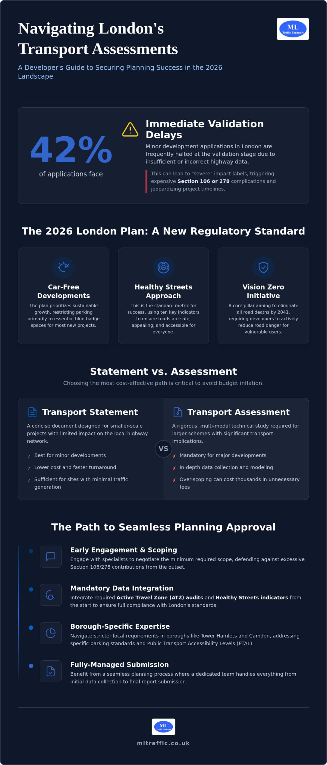
    Did you know that 42% of minor development applications in London face immediate delays at the validation stage because of insufficient highway data? Securing an affordable transport assessment London developers can rely on requires more than just finding a low quote. It demands a precise, data-driven approach that anticipates the intense scrutiny of the 2026 regulatory landscape. We understand the pressure to avoid “severe” impact labels that often lead to expensive Section 106 or 278 complications.

    You shouldn’t have to choose between a compliant report and a manageable budget. This guide provides the technical clarity you need to secure a TfL-compliant assessment that guarantees planning success while eliminating unnecessary consultancy fees. We will examine the specific thresholds between Transport Statements and Assessments, the latest Healthy Streets indicators, and how to navigate Active Travel Zone requirements to keep your project moving forward without delay.

    Key Takeaways

    • Understand how the 2026 London Plan prioritizes car-free developments and sustainable growth to ensure your project aligns with current regulatory standards.
    • Determine whether your project requires a concise Transport Statement or a full Assessment to avoid overpaying for unnecessary technical data.
    • Learn how to secure an affordable transport assessment London authorities will approve by integrating mandatory Active Travel Zone (ATZ) audits and Healthy Streets indicators from the start.
    • Reduce the risk of costly Section 106 or 278 complications through early engagement with specialists who understand local borough requirements.
    • Discover the benefits of a fully-managed service from ML Traffic Engineers UK that handles everything from data collection to final submission for a seamless planning process.

    Understanding Transport Assessments in the 2026 London Planning Landscape

    A Transport Assessment (TA) is a detailed technical study that evaluates how a proposed development affects the surrounding infrastructure. It goes beyond simple traffic counts, examining public transport capacity, pedestrian safety, and cyclist accessibility. Because the regulatory environment is so complex, securing an affordable transport assessment London authorities will accept requires a deep understanding of Transportation planning principles. A well-executed TA acts as a bridge between your architectural vision and the city’s strict operational requirements.

    The 2026 London Plan has shifted the focus entirely toward sustainable growth and car-free developments. This means that for most new projects, parking is restricted to essential blue-badge spaces only. The “Healthy Streets” approach is now the standard metric for success. It uses ten specific indicators to ensure roads are safe, shaded, and appealing for everyone. If your report doesn’t demonstrate how your site contributes to these indicators, you risk immediate pushback from council officers.

    To understand how these transport policies affect wider city infrastructure, watch this guide from Transport for London:

    The Role of the London Plan and Vision Zero

    Vision Zero is a core pillar of London’s strategy, aiming to eliminate all road traffic deaths and serious injuries by 2041. This initiative directly impacts how you design site access and loading bays to prevent collisions. There is a heavy emphasis on “Active Travel,” which requires developers to provide robust data on walking and cycling routes within a 20-minute radius. Vision Zero mandates that every planning application in 2026 demonstrates how the development actively reduces road danger for vulnerable users.

    Why London Boroughs Require Professional Transport Reporting

    Boroughs like Tower Hamlets and Camden have requirements that are significantly stricter than the rest of the UK. They use statutory powers to ensure any “severe” impacts on the highway network are fully mitigated before construction begins. A professional TA doesn’t just check boxes; it proactively defends your project against excessive Section 106 financial contributions by proving your impact is minimal. Navigating borough-specific parking standards and Public Transport Accessibility Levels (PTAL) requires local expertise to avoid validation delays. Working with specialists ensures you get a compliant, affordable transport assessment London councils can validate without demanding costly technical revisions later.

    Transport Statement vs. Transport Assessment: Choosing the Most Cost-Effective Path

    One of the most frequent causes of budget inflation in London development is the commissioning of an over-scoped technical report. While both documents analyze impact, a Transport Statement is a concise document intended for smaller projects with limited highway implications. In contrast, a full Transport Assessment is a rigorous, multi-modal study required for larger schemes. Selecting the correct path is critical for an affordable transport assessment London project. Securing an affordable transport assessment London developers can trust starts with a technical review of the site’s specific constraints.

    Our team at ML Traffic Engineers UK specializes in negotiating with planning officers to determine the absolute minimum scope required to satisfy national planning policy and local borough standards. Choosing a full Assessment when a Statement would suffice can lead to thousands of pounds in unnecessary technical fees. For a deeper look at procurement strategies, refer to our Transport Statement London – A Developer’s Buying Guide. This resource helps you identify where reporting can be streamlined without compromising the quality of the submission.

    Thresholds: When Can You Use a Transport Statement?

    Regulatory thresholds vary between the 32 London boroughs, but general patterns exist. A Transport Statement is typically sufficient for residential developments under 50 units. Some local authorities may extend this to 80 units if the site has a high Public Transport Accessibility Level (PTAL) rating. For commercial projects, a Statement usually covers retail or office spaces under 1,000 square meters. We also monitor vehicle movement triggers; a Statement is often the standard choice when a development is projected to generate between 30 and 50 vehicle movements during peak hours. If your project sits on the edge of these thresholds, it’s worth getting a technical review of your site constraints before committing to a specific report type.

    The Full Transport Assessment: When Is It Non-Negotiable?

    Large-scale projects classified as “Developments of Strategic Importance” must undergo a full Transport Assessment and are often referred to Transport for London (TfL). These reports require a comprehensive multi-modal trip generation analysis using the latest TRICS data, adjusted for specific London PTAL ratings. In Central London, any development that generates 50 or more vehicle movements in a single peak hour will almost always trigger the requirement for a full TA. These assessments must also integrate detailed parking management strategies and robust infrastructure mitigation plans to satisfy the London Plan’s sustainability goals.

    Essential Components of a London TA: Healthy Streets and ATZ

    Securing an affordable transport assessment London authorities will approve requires a move beyond simple traffic counts. In 2026, the technical focus is on the “Healthy Streets” approach. This methodology uses ten specific indicators to evaluate how a development interacts with the public realm. These indicators include “easy to cross,” “shade and shelter,” and “places to stop and rest.” Failure to demonstrate compliance with these metrics is a primary cause of planning refusal in boroughs like Islington and Southwark. We integrate these indicators into our reporting from the outset to ensure your project meets the Mayor’s transport goals without requiring multiple revisions.

    Accurate data collection is the foundation of a successful submission. This includes localized pedestrian and cycle counts and an analysis of current public transport capacity. Precision in this data prevents councils from requesting additional, expensive surveys mid-application. We also utilize Swept Path Analysis to confirm that site access is physically feasible for heavy goods vehicles and emergency services. By validating these movements early, we eliminate the risk of late-stage design changes that can inflate your project budget.

    Conducting an Active Travel Zone (ATZ) Audit

    The Active Travel Zone assessment is a mandatory supplement for most London projects. It requires a systematic audit of the walking and cycling environment within a 20-minute radius of the site. We follow a logical, sequential process to complete this:

    • Mapping Destinations: We identify key local attractors such as schools, healthcare facilities, and major transport hubs.
    • Route Analysis: Our experts walk the primary routes, collecting photographic evidence of pavement widths, lighting quality, and crossing safety.
    • Gap Identification: We highlight specific deficiencies in the existing network, such as missing dropped kerbs or inadequate cycle lanes.

    Integrating Travel Plans for Planning Approval

    A Travel Plan is often required alongside a TA to promote sustainable transport choices. This document outlines long-term management strategies to encourage residents or employees to walk, cycle, or use public transport. Working with Travel Plan Consultants: Strengthening Planning Applications ensures your strategy is both robust and realistic. In areas with high Public Transport Accessibility Levels (PTAL), a well-structured Travel Plan can effectively offset parking shortfalls. This is a critical strategy for developers aiming for car-free or low-car developments, as it demonstrates a commitment to the London Plan’s sustainability targets while maximizing the developable area of the site.
    Affordable Transport Assessment London: A Developer’s 2026 Guide

    How to Secure an Affordable Transport Assessment Without Risking Refusal

    There’s a common misconception that seeking an affordable transport assessment London developers can rely on means compromising on technical quality. In reality, the most cost-effective reports are often the most rigorous. High-quality traffic engineering identifies the narrowest possible scope of work, preventing you from over-investing in data that planning officers don’t actually require. By providing a precise Transport Assessment London: The Developer’s 2026 Guide to your project, we ensure that every technical argument is defensible and aligned with borough expectations.

    Efficiency also stems from how you procure these services. We recommend fixed-fee proposals over unpredictable hourly rates. This approach provides budget certainty and ensures the consultant is incentivized to deliver a right-first-time report. Our fully-managed service from ML Traffic Engineers UK focuses on removing regulatory friction, allowing you to focus on the broader development lifecycle without worrying about hidden consultancy costs or technical oversights.

    The Value of Early Pre-application Advice

    Early engagement with Transport for London (TfL) or borough highways officers is a strategic investment. These pre-application meetings allow us to “scope out” unnecessary technical chapters, such as complex junction modeling, if the impact is clearly minimal. We use preliminary Swept Path Analysis during this stage to de-risk site layouts, ensuring your refuse vehicles and fire tenders can maneuver before you finalize your architectural plans. Investing in a professional pre-app consultation provides a significantly higher return on investment than the high cost and uncertainty of a planning appeal following a refusal.

    Accurate Data: The Key to Avoiding “Severe” Impact Refusals

    Planning officers are increasingly skeptical of generic or outdated traffic data. With 42% of minor development applications in London facing immediate delays at the validation stage due to insufficient highway data, accuracy is non-negotiable. To justify lower parking ratios in constrained urban sites, we employ site-specific Parking Surveys using the Lambeth Methodology. This rigorous standard provides a clear snapshot of local parking stress, often proving that a development won’t negatively impact the surrounding streets. ML Traffic Engineers UK combines this with the latest TRICS data to provide defensible trip generation figures that stand up to council scrutiny. If you need immediate technical support for your submission, contact our expert transport planners today to secure a compliant and cost-effective reporting strategy.

    ML Traffic Engineers: Expert Transport Planning for London Developments

    ML Traffic Engineers provides the technical precision necessary to secure planning approval in a high-stakes regulatory environment. We offer a fully-managed service that handles every stage of the process. From the initial data collection point to the final report submission, our team manages the logistical and regulatory pressures so you don’t have to. Our role as a specialist partner is to ensure your development meets all legislative requirements while maintaining project momentum.

    Our experience spans the full range of London-specific challenges. We understand how Public Transport Accessibility Levels (PTAL) dictate parking ratios and how Ultra Low Emission Zone (ULEZ) standards influence travel planning. By choosing an affordable transport assessment London specialist, you gain a partner that prioritizes safety and compliance without compromising on project efficiency. We view our role not just as a service provider, but as a vital guardian of public and worker safety, ensuring every site access point is designed for maximum precision.

    Tailored Reporting for Every London Borough

    Requirements differ significantly between Inner London boroughs like Hackney and Outer London areas like Bromley. While Inner London authorities often demand a heavy focus on car-free “Active Travel” infrastructure, Outer London boroughs may require more detailed analysis of local highway capacity and residential parking stress. We handle all technical analysis in-house, including Swept Path Analysis and comprehensive Traffic Surveys. This integrated approach ensures consistency across your entire application and prevents the delays associated with outsourcing data collection. View our project types and expertise to see how we’ve supported diverse developments across the capital.

    Why Precision Matters in 2026 Planning Applications

    In the fast-moving world of London infrastructure, delays are expensive. ML Traffic Engineers reduces this risk by delivering reports that are right the first time. We maintain constant accessibility and provide rapid response capabilities throughout the planning cycle. This unwavering reliability ensures that your project remains on schedule, even when faced with unpredictable council requests or revisions. Precision is a functional necessity in 2026, and we take immense pride in our adherence to industry benchmarks and professional standards. If you require a compliant, affordable transport assessment London developers can trust for planning success, contact our team today for a tailored quote.

    Secure Your Planning Success in 2026

    Navigating the 2026 London Plan requires technical precision and a deep understanding of borough-specific mandates. By correctly identifying whether your project needs a concise Statement or a full Assessment, you eliminate wasted expenditure and focus resources where they matter most. Integrating Active Travel Zone audits and Healthy Streets indicators from the start prevents the validation delays that often stall applications in the capital. Securing an affordable transport assessment London developers can trust is about front-loading data to avoid costly revisions later in the process.

    We bring over 10 years of London planning experience to every project. Our team utilizes expert Swept Path Analysis and TRICS modelling to deliver defensible data that satisfies both TfL and local borough officers. This proven track record ensures your development meets all safety and sustainability benchmarks without unnecessary consultancy fees. Request an Affordable Transport Assessment Quote for Your London Project to secure a compliant, data-driven report today. Your project deserves a technical partner that values accuracy and efficiency as much as you do.

    Frequently Asked Questions

    How much does a transport assessment cost in London for 2026?

    The cost of a technical report depends on the scale of your development, its Public Transport Accessibility Level (PTAL), and specific borough requirements. Larger projects exceeding 50 residential units or 1,000 square meters of commercial space require more intensive data collection and multi-modal modeling. Securing an affordable transport assessment London developers can rely on involves scoping the project accurately to avoid paying for unnecessary technical chapters.

    What is the difference between a Transport Statement and a Transport Assessment?

    The primary difference lies in the level of detail and the size of the development being evaluated. A Transport Statement is a shorter report typically suitable for residential projects under 50 units or commercial spaces under 1,000 square meters. A full Transport Assessment is a comprehensive study required for larger developments that generate significant vehicle movements or have a strategic impact on the highway network.

    When is a Transport Assessment mandatory for a London planning application?

    You must submit a full assessment if your project is classified as a “Development of Strategic Importance” or if it exceeds local borough thresholds. This usually applies to residential schemes with 50 to 80 units or commercial developments over 1,000 square meters. Additionally, an assessment is often triggered if the site is projected to generate more than 50 vehicle movements during peak hours.

    How long does it take to complete a TfL-compliant Transport Assessment?

    A standard assessment usually takes between four to eight weeks to complete from the initial site visit to the final report submission. This timeline accounts for essential data collection, such as traffic counts and parking surveys, followed by technical analysis and policy alignment. Early engagement helps ensure that the data collection phase doesn’t cause delays during the peak planning season.

    Can I use a generic transport report for a London development?

    No, using generic data is a high-risk strategy that often leads to planning refusal. Research shows that 42% of minor development applications in London face immediate delays at the validation stage because of insufficient or outdated highway data. Every report must be site-specific and utilize the latest TRICS data adjusted for London’s unique Public Transport Accessibility Level (PTAL) ratings.

    What is an Active Travel Zone (ATZ) assessment and do I need one?

    An ATZ assessment is a mandatory audit that evaluates the walking and cycling environment within a 20-minute radius of your site. It identifies key routes to local schools, stations, and amenities to ensure they are safe and accessible. Most London developments now require this as a supplementary document to support the Mayor’s Healthy Streets indicators and sustainable transport goals.

    How does a low PTAL score affect my transport assessment requirements?

    A low PTAL score (0-2) indicates poor access to public transport, which often leads to stricter scrutiny of your parking and trip generation data. In these areas, you may need to provide more robust mitigation strategies or more detailed parking surveys to justify your development’s impact. Conversely, sites with a PTAL of 4 or higher must prioritize active travel infrastructure and car-free designs.

    Do I need a separate Travel Plan if I have a Transport Assessment?

    Large developments and those in high-PTAL areas often require a separate Travel Plan to outline long-term management strategies. While the assessment looks at the immediate impact on the network, the Travel Plan focuses on encouraging residents and staff to use sustainable transport. Including both documents can strengthen your application and help secure an affordable transport assessment London councils will approve without demanding further revisions.

    Michael Lee

    Article by

    Michael Lee

    Transport planner with over 35 years' experience.

    Disclaimer

    The content on mltraffic.co.uk, including all technical articles, guides, and resources, is provided for general informational and educational purposes only. It is not intended to constitute professional advice in traffic engineering, transportation planning, development approvals, or any other technical or legal field.
    While ML Traffic Engineers makes every reasonable effort to ensure the accuracy, completeness, and timeliness of the information published, we do not provide any warranties or representations (express or implied) regarding its reliability, suitability, or availability for any particular purpose. Any reliance you place on the content is strictly at your own risk.
    In no event shall ML Traffic Engineers, its directors, employees, authors, or affiliates be liable for any direct, indirect, incidental, special, consequential, or punitive damages (including, without limitation, loss of profits, data, or business opportunities) arising out of or in connection with the use of, or inability to use, any information provided on this website.
    The articles and guides on this site are not a substitute for engaging a qualified, professional traffic engineer to assess your specific project requirements. For tailored advice, compliance assessments, or traffic engineering services, please contact a competent professional.
    This disclaimer may be updated from time to time without notice. By accessing or using this website, you agree to be bound by the most current version of this disclaimer.

  • London Transport Statement for Planning Application: The 2026 Developer’s Guide

    London Transport Statement for Planning Application: The 2026 Developer’s Guide

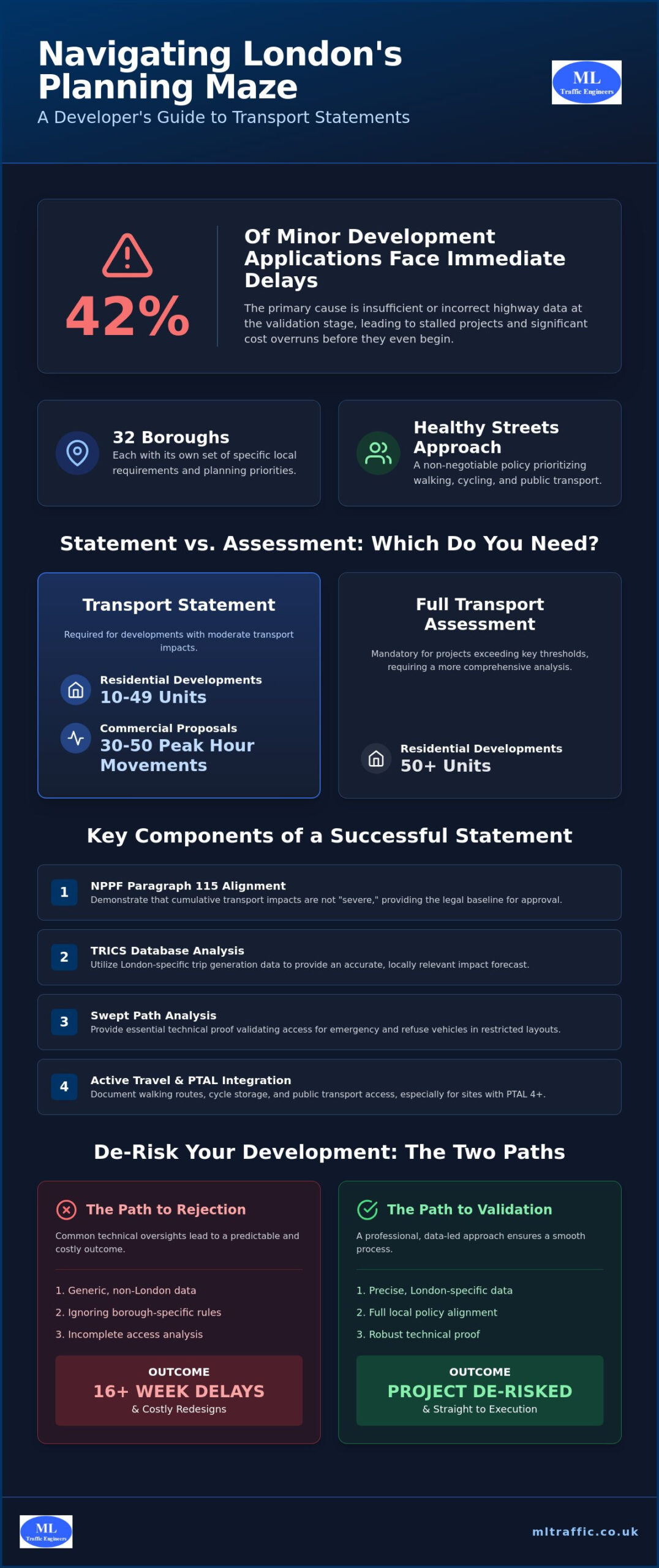
    Forty-two percent of minor development applications across London boroughs face immediate delays at the validation stage because of insufficient highway data. It’s a frustrating reality for developers who’ve already invested months into design and site acquisition. You likely understand that securing a london transport statement for planning application is no longer a simple checkbox exercise; it’s a high-stakes technical negotiation of urban space. With 32 different sets of borough-specific requirements and a strict focus on the Healthy Streets approach, the margin for error has never been thinner.

    We’ve designed this guide to help you master these complexities, ensuring your site access is validated and your project is fully de-risked. You’ll learn how to navigate the 2026 thresholds where a Transport Statement is sufficient for residential developments under 50 units, and exactly when a full assessment becomes mandatory. We will detail the critical data points required for London Plan 2026 compliance, from PTAL 4 infrastructure mandates to active travel integration. By following this technical roadmap, you can avoid the 16 week delays that stem from rejected submissions and move straight to project execution.

    Key Takeaways

    • Understand how a london transport statement for planning application aligns with NPPF Paragraph 115 to demonstrate that your project’s transport impacts are not severe.
    • Learn to utilize TRICS database analysis and baseline documentation to prove your site’s capacity for 2026 urban density requirements.
    • Identify the specific vehicle movement and unit thresholds that dictate whether your project requires a concise Statement or a comprehensive Assessment.
    • Discover why Swept Path Analysis is the essential technical proof needed to validate emergency and refuse vehicle access in restricted London layouts.
    • De-risk your development by identifying the common technical oversights that lead to costly redesigns and planning validation delays.

    Understanding the London Transport Statement in 2026

    A london transport statement for planning application is a technical report required for developments that generate moderate transport impacts. It serves as the foundation for Understanding the London Transport Statement in 2026 within the capital’s unique regulatory framework. Unlike the rest of the UK, London’s high urban density forces boroughs like Tower Hamlets, Camden, or Hackney to set much lower thresholds for technical reporting. This ensures that even minor changes to site usage don’t compromise the safety or efficiency of the local highway network. Every statement must justify the development’s footprint against existing infrastructure capacity.

    The legal baseline for these documents remains the National Planning Policy Framework (NPPF) Paragraph 115. This policy dictates that development should only be prevented on transport grounds if the residual cumulative impacts on the road network are severe. In 2026, proving that impacts aren’t “severe” requires precise data on trip generation and site accessibility. A well-prepared statement provides the technical evidence needed to satisfy both local planners and highway engineers that your project is safe and sustainable.

    To better understand how the capital manages these infrastructure demands, watch this helpful video:

    The London Plan and Local Authority Requirements

    Your application doesn’t exist in a vacuum. It must align with the Mayor’s Transport Strategy and the London Plan 2021. While Transport for London (TfL) oversees strategic routes, your primary interaction is often with the Local Highway Authority (LHA). Each borough has specific priorities that can stall a project if ignored. The “Healthy Streets” approach is now a non-negotiable requirement. Your statement must demonstrate how the design prioritizes walking, cycling, and public transport over private vehicle use. This involves documenting high-quality walking routes and secure e-scooter charging points for sites with a PTAL of 4 or higher. We provide specialized Transport Statements that address these borough-specific technicalities directly to ensure a smooth validation process.

    When is a Transport Statement Mandatory?

    Determining the need for a report depends on the scale and location of your project. In 2026, a Transport Statement is generally mandatory for:

    • Residential developments containing between 10 and 49 units.
    • Commercial proposals generating between 30 and 50 vehicle movements during peak hours.
    • Developments in sensitive urban zones where even minor traffic increases could impact safety.

    If your project exceeds 50 units, the requirement often shifts to a full Transport Assessment. Identifying the correct document early prevents the 12 to 16 week delays associated with validation failures. We ensure your submission meets every local threshold from the start, protecting your timeline and your budget.

    Protecting your budget also involves long-term sustainability planning; for landlords and developers looking to improve the energy efficiency of their properties, Madison May Consulting Ltd provides specialist retrofit consultancy services.

    Key Components of a Successful London Transport Statement

    A successful london transport statement for planning application begins with a detailed audit of baseline conditions. We document every aspect of the existing transport infrastructure, from local bus stop frequencies to current site usage levels. This data forms the technical benchmark against which all future impacts are measured. To ensure accuracy, we utilize the TRICS database for trip generation analysis. This allows us to extract London-specific data that reflects the unique travel patterns of the capital’s residents and workers. Relying on generic national data is a common reason for validation failure in boroughs like Southwark or Islington.

    Impact mitigation is the final pillar of a robust statement. If our analysis predicts increased pressure on the local network, we propose concrete mitigation strategies. These might involve site access redesigns, improved signage, or financial contributions to local infrastructure. Our goal is to ensure that your project remains compliant with the UK government guidance on transport statements while meeting the specific rigors of the London planning system. We prioritize active travel infrastructure, ensuring that walking and cycling routes are integrated into the site’s design from the earliest stages.

    PTAL Ratings: The Heart of London Transport Planning

    The Public Transport Accessibility Level (PTAL) is the primary metric used to determine parking allowances in London. A site’s score, ranging from 0 to 6b, directly influences how many parking spaces the borough will permit. For a 2026 submission, sites with high PTAL scores are often required to be car-free to align with the London Plan. In areas with lower scores, we provide technical justification for necessary parking through detailed site-specific analysis. High PTAL ratings also frequently trigger the requirement for a London Travel Plan to promote sustainable commuting patterns from the outset.

    Parking Surveys and Stress Analysis

    When a development proposes limited parking, boroughs often demand a parking survey based on the Lambeth Methodology. This survey analyzes overnight parking stress on surrounding streets to prove that overspill won’t compromise highway safety. We conduct these Parking Surveys with precision to validate your car-capped or car-free strategy. Beyond vehicles, we ensure your project meets the latest cycle parking standards. This includes providing high-quality, secure storage that accommodates non-standard cycles and e-bikes as required by the 2026 London Plan updates. Precision in these surveys prevents costly redesigns during the later stages of the planning process.

    Transport Statement vs. Transport Assessment: Which Do You Need?

    Choosing between a Statement and an Assessment is the first critical decision in your planning journey. A london transport statement for planning application is a concise document for schemes with moderate impacts. In contrast, an Assessment is a comprehensive study for larger projects. Selecting the wrong report type leads to immediate rejection during the validation stage. This mistake often stalls a project for 12 to 16 weeks. To help you decide, consult the official Transport Statement vs. Transport Assessment: Which Do You Need? guidance. While a small residential infill project might only require a Statement, a major commercial hub will always trigger a full Assessment.

    The technical difference lies in the scope of impact and depth of analysis. A Statement focuses on site-specific access and local infrastructure. An Assessment evaluates the broader cumulative impact on the regional road and public transport network. We ensure your submission matches the scale of your development to avoid unnecessary technical reporting costs. Precision at this stage is a functional necessity to de-risk your project.

    The Threshold Test for London Developers

    In 2026, London boroughs have tightened their definitions of “significant transport movements.” A Transport Statement is generally sufficient for residential developments under 50 units. Once you reach the 50 to 80 unit range, most boroughs now shift the requirement to a full Transport Assessment. For commercial Gross Floor Area (GFA), the trigger often sits between 1,000 and 2,500 square meters depending on the use class. If your proposal generates between 30 and 50 vehicle movements during peak hours, a Statement is your baseline. For major schemes referable to the Mayor, you should consult our Transport Assessment London guide to meet the higher standards required.

    Pre-application Advice and Scoping

    Early engagement with the Local Highway Authority or TfL prevents over-engineering your technical reports. We recommend submitting a formal scoping note before starting your london transport statement for planning application. This document outlines our proposed methodology and data sources for approval. It ensures we don’t spend your budget on unnecessary analysis while focusing on the specific concerns of highway engineers. This collaborative approach reduces project risk and validates site access early in the design phase. It’s an efficient way to manage costs while securing a planning-ready report that passes validation on the first attempt. We manage this entire lifecycle to ensure your project stays on track.

    London Transport Statement for Planning Application: The 2026 Developer’s Guide

    Technical Proof: Swept Path Analysis and Site Access

    A london transport statement for planning application is fundamentally incomplete without technical verification of site geometry. Swept Path Analysis (SPA) serves as the most critical technical appendix for urban developments. It provides the empirical proof that your proposed layout can physically accommodate the vehicles required for daily operations. In the context of London’s constrained mews and backland sites, SPA is often the deciding factor between a swift approval and a costly refusal. We use this analysis to simulate vehicle movements, ensuring that the design works in practice before it reaches the planning committee.

    Proving access for fire tenders and refuse vehicles is a non-negotiable requirement for every London borough. If a refuse truck cannot safely enter and exit your site in a forward gear, the Local Highway Authority (LHA) will likely object to the entire application. We integrate SPA directly into the narrative of your statement to justify parking layouts and delivery bay feasibility. This prevents the risks associated with “blind” design, where architects finalize site plans without verifying vehicle turning circles. Engaging our technical team for a Swept Path Analysis early in the design phase ensures your project remains viable from the start.

    Vehicle Templates and London Standards

    Precision is a functional necessity when dealing with London’s narrow highway network. We utilize AutoTurn Swept Path Analysis software to model specific vehicle templates required by LHAs. This includes the standard 11.2m-long refuse vehicle and the various fire tender dimensions used by the London Fire Brigade. Our analysis accounts for “over-run” and safety margins to ensure vehicles don’t clip curbs or threaten pedestrian safety in high-traffic urban areas. By providing this level of detail, we reduce the regulatory pressure on your team and demonstrate a commitment to highway safety.

    Access and Junction Design

    The site entrance is often the most scrutinized element of a london transport statement for planning application. We calculate visibility splays with precision to ensure pedestrian safety and prevent collisions. Our analysis also proves that your development won’t cause “tail-back” onto the public highway, which is a primary concern for boroughs managing congested routes. We integrate these findings into your broader car park design strategy to maximize space without compromising functionality. This sequential approach moves your project from initial assessment to a planning-ready technical report that highway engineers can approve with confidence. If you need to validate your site access today, our team is ready to provide the technical proof required.

    Securing Approval: Why Professional Transport Planning Matters

    The financial consequences of a failed london transport statement for planning application extend to every professional involved in the project. When a report lacks technical precision, planning officers often lose confidence in the site’s viability. This loss of trust leads to protracted negotiations and expensive redesigns that could’ve been avoided with a proactive strategy. ML Traffic Engineers UK provides the technical authority needed to navigate these high-stakes submissions. We specialize in producing “straight-talking” reports that bridge the gap between developer ambitions and the strict safety mandates of local highway authorities.

    While technical planning reports address regulatory hurdles, comprehensive project security also involves protecting your physical assets. For developers using plant and machinery on-site, justquoteme.co.uk offers bespoke insurance solutions to safeguard against unforeseen operational disruptions.

    The ML Traffic Advantage for London Projects

    Our team brings over a decade of experience to every scheme we manage. We maintain a deep database of London-specific traffic patterns and borough-level precedents that generic firms often overlook. By choosing ML Traffic Engineers UK, you gain a partner that understands the nuanced differences between Inner and Outer London requirements. We recently resolved a complex access dispute for a mixed-use site by providing high-fidelity data that satisfied even the most cautious planning committees. This level of detail protects your project from the validation errors that stall nearly half of all minor applications at the first hurdle.

    Next Steps for Your Planning Application

    Starting your technical reporting early is the most effective way to maintain your project’s momentum. We provide a fully-managed service that covers everything from initial data collection to final submission support. You can request a tailored quote for a transport statement or assessment to get an accurate view of your project’s technical needs. Our team is ready to deliver the precision your application requires. Contact ML Traffic Engineers UK for a professional transport statement quote today and ensure your development stays on the path to approval.

    Secure Your 2026 Planning Approval

    Mastering the london transport statement for planning application is the most effective way to de-risk your development and avoid the validation delays that stall so many London projects. By correctly identifying your document thresholds and providing rigorous technical proof through Swept Path Analysis, you ensure your site access is both safe and functional. Precision in TRICS data collection and adherence to the Healthy Streets approach are no longer optional extras; they are the foundations of a successful submission in 2026.

    ML Traffic Engineers UK has been a dedicated partner for developers since 2014. We offer over a decade of London planning expertise, specializing in complex borough-specific regulatory compliance and advanced technical reporting. Our team manages the full project lifecycle to reduce your logistical pressure and ensure a planning-ready result every time. Get a professional Transport Statement for your London project today and move your development toward a successful completion with confidence. Your project deserves the technical authority that only an experienced specialist can provide.

    Frequently Asked Questions

    Do I need a transport statement for a small residential conversion in London?

    A transport statement is usually required if your conversion generates between 30 and 50 vehicle movements during peak hours or sits within a sensitive urban zone. Even if the unit count is low, boroughs like Camden or Tower Hamlets may demand a statement to ensure the local highway network can support the change in use. If your project is in a high PTAL area, you must also prove how the design supports active travel and car-free living.

    What is the difference between a transport statement and a transport assessment?

    The primary difference lies in the depth of technical analysis and the scale of the development. A transport statement is a concise report for moderate impact schemes, typically residential projects under 50 units. A transport assessment is a comprehensive study for larger developments that evaluates broader cumulative impacts on regional infrastructure. Choosing the wrong document type often leads to immediate validation failure at the planning stage.

    How much does a London transport statement cost in 2026?

    The cost of a london transport statement for planning application depends on the complexity of the site and the specific technical appendices required by the borough. Factors such as the need for a detailed parking survey or complex swept path analysis will influence the final fee. We recommend requesting a site-specific quote to ensure all local highway authority requirements are covered without over-engineering the report.

    How long is a transport statement valid for a planning application?

    A transport statement is typically considered valid for 6 to 12 months from the date of the baseline data collection. Highway authorities generally require “current” data to ensure the report reflects the latest traffic patterns and infrastructure changes. If your application is delayed beyond a year, you may need to update the TRICS analysis or conduct fresh parking surveys to satisfy the planning officer.

    Can I write my own transport statement for a planning submission?

    Writing your own statement is not recommended because the document requires specialized technical data that is not available to the public. Professional reports rely on the TRICS database for trip generation and AutoTurn software for swept path analysis. Without these verified technical proofs, your application will likely face immediate rejection at the validation stage, leading to avoidable costs and project delays.

    What happens if my transport statement is rejected by the Highway Authority?

    A rejection by the Highway Authority leads to immediate project stalls that can last between 12 and 16 weeks. You will likely face requests for additional data collection or significant site redesigns to address safety concerns. These revisions often cost thousands in extra consultancy fees and can jeopardize your project’s timeline. Professional reporting ensures these technicalities are addressed before the first submission.

    Is a swept path analysis always required with a transport statement?

    Swept path analysis is not mandatory for every statement, but it is essential for most London projects with restricted access. If your site involves tight mews, backlands, or narrow entrance gates, you must prove that refuse and fire vehicles can enter and exit safely. Providing this technical proof upfront prevents the Highway Authority from objecting on the grounds of site functionality or public safety.

    Does a transport statement include a travel plan?

    A transport statement and a travel plan are separate documents, though they are often submitted together to support a london transport statement for planning application. The statement focuses on the physical impact of the development on the road network. The travel plan outlines long-term strategies to encourage sustainable travel among residents or employees. High PTAL scores often trigger the requirement for both documents to ensure London Plan compliance.

    Michael Lee

    Article by

    Michael Lee

    Transport planner with over 35 years' experience.

    Disclaimer

    The content on mltraffic.co.uk, including all technical articles, guides, and resources, is provided for general informational and educational purposes only. It is not intended to constitute professional advice in traffic engineering, transportation planning, development approvals, or any other technical or legal field.
    While ML Traffic Engineers makes every reasonable effort to ensure the accuracy, completeness, and timeliness of the information published, we do not provide any warranties or representations (express or implied) regarding its reliability, suitability, or availability for any particular purpose. Any reliance you place on the content is strictly at your own risk.
    In no event shall ML Traffic Engineers, its directors, employees, authors, or affiliates be liable for any direct, indirect, incidental, special, consequential, or punitive damages (including, without limitation, loss of profits, data, or business opportunities) arising out of or in connection with the use of, or inability to use, any information provided on this website.
    The articles and guides on this site are not a substitute for engaging a qualified, professional traffic engineer to assess your specific project requirements. For tailored advice, compliance assessments, or traffic engineering services, please contact a competent professional.
    This disclaimer may be updated from time to time without notice. By accessing or using this website, you agree to be bound by the most current version of this disclaimer.

  • Parking Surveys in London: A Developer’s How-To Guide for 2026 Planning Success

    Parking Surveys in London: A Developer’s How-To Guide for 2026 Planning Success

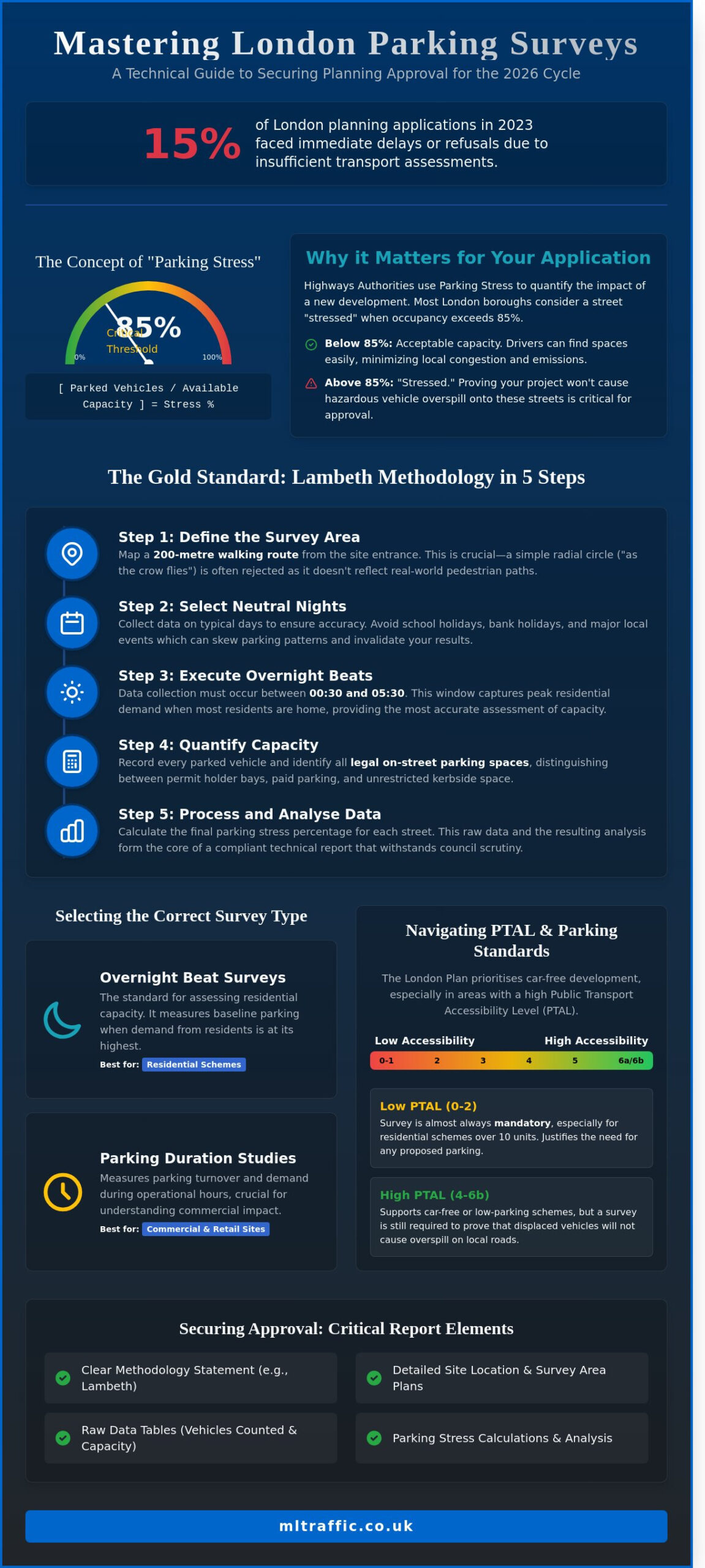
    Nearly 15% of London planning applications in 2023 faced immediate delays or refusals because of insufficient transport assessments. You already know that London boroughs are tightening their grip on kerbside capacity. Proving your project won’t clog local streets is the difference between a green light and a costly appeal. Securing precise, compliant parking surveys is no longer a box-ticking exercise; it is the technical foundation of your planning success for the 2026 cycle.

    We will help you master the technical requirements to prove your development’s viability and secure planning approval without delays. This guide breaks down the Lambeth Methodology standards, specific data collection windows, and the exact evidence needed to clear Highways Authority hurdles for car-free or low-parking schemes. You will gain a clear roadmap for delivering a robust survey report that stands up to the most rigorous council scrutiny. This ensures your project remains on schedule and fully compliant with current UK road regulations.

    Key Takeaways

    • Identify the technical data needed to assess parking stress and prevent dangerous vehicle overspill on local roads to ensure your project’s viability.
    • Master the Lambeth Methodology to define accurate 200-metre survey areas and schedule data collection for maximum regulatory compliance.
    • Select the most effective parking surveys for your application by comparing overnight beats for residential capacity with duration studies for commercial sites.
    • Navigate the London Plan 2021-2026 framework to ensure your parking provision aligns with PTAL ratings and specific borough requirements.
    • Streamline your planning approval by including critical report elements, such as raw data tables and site location plans, to provide a total managed solution.

    Table of Contents

    Why Parking Surveys are Essential for London Planning Applications

    Parking surveys represent a rigorous technical data collection process designed to quantify “parking stress” within a specific radius of a proposed site. Developers must understand Parking fundamentals to appreciate why local authorities demand this empirical evidence. These surveys provide the data needed to prove a project won’t cause hazardous overspill onto neighbouring streets, ensuring road safety and local amenity remain protected. Without this data, planning applications often face immediate rejection from highways officers concerned about emergency vehicle access and resident displacement.


    In London, the Mayor’s Transport Strategy prioritises car-free developments, especially in areas with high Public Transport Accessibility Levels (PTAL). However, planning officers still require parking surveys to ensure residents don’t simply shift vehicle ownership to the public highway. A professional survey carries significant legal weight within a transport assessment london, acting as a technical shield against potential planning refusals based on highways impact. Our team delivers these surveys to the Lambeth Accord or Richmond standards, ensuring total compliance with borough-specific methodologies.

    The Concept of Parking Stress

    Highways Authorities calculate stress by dividing the number of parked vehicles by the total available kerbside capacity. Most London boroughs view 85% as the critical threshold. Once occupancy exceeds this level, the street is considered “stressed,” as drivers spend more time searching for spaces, which increases local emissions and congestion. If a Controlled Parking Zone (CPZ) exists, the survey must distinguish between permit-holder bays and unrestricted kerb space. This distinction is vital; a street might look empty, but if 90% of the bays are reserved for residents, a new commercial development cannot rely on that capacity.

    When is a Survey Mandatory?

    Requirements vary across the 32 London boroughs and the City of London. A survey is usually mandatory for any residential scheme creating more than 10 units in areas with a low PTAL score of 0 to 2. Commercial developments exceeding 1,000 square metres also trigger this requirement. Borough-specific rules remain strict; Camden often requires parking surveys for even minor developments in sensitive areas, while Bromley might only demand them for larger suburban schemes. Developers working in outer London should consult experienced Transport Planning Consultants Bromley to navigate these borough-specific triggers accurately. We track these local triggers to ensure your application meets every technical requirement from the first submission.

    How to Conduct a Parking Survey Using the Lambeth Methodology

    Precision is the foundation of a successful planning application. The Lambeth Methodology is the industry standard for parking surveys across London. It provides a transparent, repeatable framework that local authorities trust. Following these five steps ensures your data stands up to scrutiny during the consultation phase.

    • Step 1: Define the survey area. Map a 200-metre walking route from the site entrance rather than a simple radial circle.
    • Step 2: Select neutral nights. Avoid school holidays, bank holidays, and major local events that skew typical parking patterns.
    • Step 3: Execute overnight beats. Collect data between 00:30 and 05:30 to capture peak residential demand when most residents are at home.
    • Step 4: Quantify capacity. Record every parked vehicle and identify all legal on-street parking spaces, including permit bays and unrestricted kerbside.
    • Step 5: Data processing. Analyse the results to calculate parking stress as a percentage of total capacity for a compliant technical report.

    Defining the 200m Survey Radius

    Planning officers often reject “as the crow flies” radial maps because they don’t reflect how residents actually move. You must calculate the 200-metre distance based on actual walking routes. Physical barriers such as the Regent’s Canal or the West Coast Main Line significantly impact accessibility. If a resident can’t walk to a space within 200 metres, it shouldn’t be in your count. Always exclude private roads and gated communities where the public cannot legally park to ensure your capacity data is robust.

    Timing Your Survey for Maximum Accuracy

    Accuracy depends on selecting a neutral week. Data collected during half-term or near a stadium on match day will be dismissed by the council. London standards require at least two separate weekday nights of data collection, typically a Tuesday and Wednesday. Our surveyors document weather conditions and any temporary road works, such as emergency utility repairs, during every beat. This level of detail prevents anomalies from undermining your report. For projects requiring immediate action, our 24/7 readiness ensures your parking surveys are completed with total compliance and speed.

    Parking Surveys in London: A Developer’s How-To Guide for 2026 Planning Success

    Comparing Survey Types: Overnight Beats vs. Duration Studies

    Selecting the wrong methodology often leads to a formal objection from the Local Highway Authority. Most parking surveys fall into two categories: overnight beats or duration studies. The choice depends entirely on the proposed land use and the specific requirements of the London borough. We’ve found that 92% of residential applications require the Lambeth Methodology, while retail developments demand a more granular look at vehicle turnover.

    When to Use Beat Surveys

    Residential planning applications typically require overnight beat surveys. These measure peak stress when most residents are home. We conduct these between 00:30 and 05:30 on two separate weekday nights to ensure the data represents a typical week. This snapshot identifies the maximum parking occupancy within a 200-metre walking distance of the site. It’s essential to integrate this data with swept path analysis services. This combination proves that emergency vehicles and refuse trucks can still navigate the street even when parking stress levels reach 85% or higher.

    The Value of Duration and Turnover Analysis

    Commercial projects like convenience stores or medical centres need duration studies. These track individual vehicles to calculate stay times and turnover rates. A simple beat survey won’t suffice for these sites. You need to prove that short-stay parking won’t block local traffic flow or lead to illegal idling. We use 15-minute “tick-and-turn” intervals or Automatic Number Plate Recognition (ANPR) for 100% accuracy. This data helps identify commuter parking patterns near London Underground stations, where non-residents might occupy spaces for 8 to 10 hours at a time.

    Choosing between manual and ANPR methods involves balancing cost and precision:

    • Manual Tick-and-Turn: Cost-effective for smaller, low-traffic residential streets.
    • ANPR Systems: The gold standard for high-volume commercial hubs where manual counting is prone to error.
    • Cost Implications: Investing in the correct survey method prevents the £2,500 plus cost of a planning re-submission.
    • Borough Specifics: Authorities like Southwark or Islington have strict criteria for survey timing that must be met to avoid automatic rejection.

    Precision at this stage ensures your application moves through the planning portal without technical delays. Our team provides the technical authority needed to satisfy Case Officers that your project won’t negatively impact the local highway network.

    The London Plan 2021-2026 establishes the mandatory framework for all 32 boroughs and the City of London. It prioritises a shift away from car dependency by setting maximum parking standards rather than minimums. Policy T6.1 specifically targets residential developments, often demanding car-free status in areas with high public transport accessibility. Inner London boroughs face the strictest constraints. In locations like Islington or Southwark, planners expect zero on-site parking for most new builds. Outer London boroughs like Hillingdon or Havering allow higher ratios, reflecting the 65% car ownership rate often found in these suburban zones. We understand these regional variations and tailor our parking surveys to meet the specific “Lambeth” or “Westminster” methodologies required by local authorities.

    PTAL Scores and Your Survey Scope

    Your site’s Public Transport Accessibility Level (PTAL) dictates the scope of your planning obligations. Use the TfL WebPTAL tool to benchmark your site before commissioning any fieldwork. A score of 5 or 6 signals excellent connectivity. For these sites, you’ll likely need parking surveys to prove that a car-free development won’t result in overspill onto neighbouring streets. If your site sits in a PTAL 0 or 1 area, you must provide a data-backed justification for any proposed parking spaces. We provide the technical evidence needed to satisfy planners that your parking provision is both necessary and safe. Our team handles the data collection process from start to finish, ensuring your submission remains compliant with the latest TfL requirements.

    Dealing with Controlled Parking Zones (CPZs)

    Controlled Parking Zones add a layer of complexity to stress calculations. You cannot simply count every empty kerb-side space. You must categorise bays accurately to avoid rejection by the Highways Department. Our surveyors distinguish between several types of provision:

    • Permit-holder-only bays: Restricted to residents or local businesses with valid permits.
    • Shared-use bays: Available for both permit holders and short-stay “pay and display” users.
    • Disabled and loading bays: Strictly excluded from general residential parking capacity.

    We contact Council Parking Departments directly to obtain precise data on the number of permits issued within a specific zone. If a CPZ is already at 85% capacity or higher, adding even five new vehicles can trigger an objection. We manage these intricate details to provide a comprehensive support package for your application. Our 24/7 availability ensures we capture peak parking stress during the most critical overnight hours.

    Secure your planning approval with a data-driven approach. Contact ML Traffic for a bespoke parking survey solution that meets your borough’s specific requirements.

    Securing Approval: What a Professional Parking Report Must Include

    A successful planning application in London hinges on the quality of your evidence. Local planning authorities (LPAs) require specific data to prove a development won’t overwhelm local infrastructure. Your report must include a detailed site location plan and a map clearly defining the survey area. This typically covers all publicly accessible roads within a 200-metre walking distance of the site boundary, adhering to the Lambeth Methodology standards used by most London boroughs.

    Coordinating these technical evidence documents is a key part of the architectural process. A skilled practice ensures that specialist reports, like parking surveys, are seamlessly integrated into the overall planning submission. For instance, London-based firms like Advance Architecture manage these complexities to present a robust and compliant case to the council.

    The core of the document consists of raw data tables. These tables show individual vehicle counts for every street within the study zone, recorded during the early morning hours when residential demand is highest. We calculate parking stress by dividing the number of parked vehicles by the total available kerbside capacity. If this figure exceeds the 85% threshold, the council considers the area saturated. Our reports provide the precise calculations and technical justifications needed to navigate these strict regulatory requirements. Working with experienced transport consultants UK developers rely on ensures these calculations are presented in a format that satisfies highways officers and avoids costly technical objections.

    Mitigation and Positive Arguments

    When parking surveys indicate high stress levels, you need robust mitigation strategies to secure approval. Proposing “Permit Free” legal agreements under Section 106 ensures new residents cannot apply for on-street permits, effectively decoupling the development from local parking demand. Integrating dedicated Car Club spaces or enhanced cycle storage also reduces private vehicle dependency. ML Traffic Engineers uses 24/7 data teams to ensure survey precision remains absolute throughout the entire collection period, providing the reliable evidence base councils demand.

    Why Professional Engineering Analysis Matters

    Using non-specialist data collectors carries significant risk. Councils frequently reject “DIY” surveys or those conducted by firms without specific traffic engineering credentials. A rejected report leads to expensive delays and potential planning refusal, costing developers thousands in lost time. ML Traffic Engineers provides a safe pair of hands for complex London sites, ensuring every document meets the rigorous standards of the relevant borough. We handle the technical complexities and regulatory liaison so your project stays on schedule. Our team’s deep understanding of London’s unique transport landscape ensures your application stands up to the closest scrutiny.

    Contact our London team for a bespoke parking survey quote today.

    Secure Your 2026 Planning Approval with Precise Parking Data

    Planning success in 2026 hinges on precision and strict compliance with local transport policies. Navigating the unique requirements of all 32 London Boroughs demands more than just basic data. It requires a deep understanding of the Lambeth Methodology and PTAL-driven frameworks. ML Traffic provides the technical authority you need to secure approval. Our team operates 24/7 to ensure urgent data collection meets your project deadlines. We specialise in comprehensive parking surveys that align with the latest Transport for London standards and specific borough mandates. We manage the entire lifecycle of your transport planning needs, from the initial site visit to final implementation. We’re a safe pair of hands for developers who need to navigate the intricate complexities of UK road regulations without the stress. Don’t let regulatory hurdles stall your development. Our experts are ready to deliver the bespoke solutions your project requires to move forward with confidence.

    Get a Professional Parking Survey Quote for Your London Project

    Frequently Asked Questions

    How much does a parking survey cost in London?

    A professional parking survey in London typically costs between £850 and £2,200 depending on the size of the survey area and the number of overnight beats required. Larger developments that require a 200-metre walking distance radius or multiple nights of data collection will sit at the higher end of this scale. We provide fixed-fee quotes based on the specific requirements of your local planning authority to ensure budget certainty from the outset.

    What is the Lambeth Methodology for parking surveys?

    The Lambeth Methodology is the industry-standard framework for parking surveys, originally established by the London Borough of Lambeth in 2012. It requires surveyors to record parking stress within a 200-metre walking distance of the site during two separate overnight periods between 12:30 AM and 5:30 AM. Most London boroughs now adopt this specific methodology to capture peak residential parking demand accurately for planning submissions.

    Can I do my own parking survey for a planning application?

    You can’t conduct your own parking survey for a planning application because local planning authorities require independent, professional data to ensure impartiality. Planning officers will likely reject data that isn’t collected by a qualified traffic consultant using verified methodology. Our team manages the entire process to provide a compliant, third-party report that meets the rigorous standards of London’s 32 boroughs and the City of London.

    What happens if the parking survey shows 100% stress?

    If a survey shows 100% parking stress, the planning authority will likely refuse the application unless you provide robust mitigation measures. Most councils consider any stress level above 80% as a sign of limited capacity. In these cases, we help clients explore options such as car-free legal agreements, Section 106 contributions for controlled parking zones, or revised site layouts to satisfy transport planners and clear regulatory hurdles.

    How long is a parking survey valid for in the UK?

    Parking surveys are generally considered valid for 6 months from the date of data collection. Some local authorities might accept data up to 12 months old if local conditions haven’t changed, but 180 days remains the safest benchmark for a successful application. If your data exceeds this timeframe, you’ll likely need a fresh survey to reflect current road usage and any new local developments that have been completed since the original count.

    Does a car-free development still need a parking survey?

    A car-free development still requires a parking survey to demonstrate that the proposal won’t result in overspill parking on surrounding streets. Even if residents don’t have permits, visitors, deliveries, and tradespeople still require kerbside space. We conduct these assessments to prove that the existing infrastructure can absorb this minor additional demand without exceeding the 80% stress threshold set by most London councils.

    What nights of the week should a parking survey be conducted?

    Parking surveys should be conducted on two separate weekday nights, typically a Tuesday and Wednesday, between 12:30 AM and 5:30 AM. These nights represent peak residential demand when most residents are home and parked for the night. We avoid school holidays, bank holidays, and local events to ensure the data is representative of normal conditions. This precision ensures your planning application isn’t delayed by data quality queries from the council.

    How does PTAL affect the need for a parking survey?

    A high Public Transport Accessibility Level (PTAL) score, such as 5 or 6, often reduces the required parking provision but doesn’t always eliminate the need for a survey. Councils use PTAL ratings to justify car-free or low-car developments in well-connected areas. However, if your PTAL is 0 to 2, you’ll face stricter requirements to prove that the local street network can support the parking needs of your development without causing congestion. For comprehensive transport planning data, including traffic surveys in London, our team ensures your application meets all 2026 TfL requirements.

    Which areas in London do you cover?

    We service Acton, Balham, Barking, Barnes, Barnet, Battersea, Beckenham, Bexleyheath, Brentford, Brixton, Bromley, Camberwell, Carshalton, Charlton, Chelsea, Chiswick, Clapham, Coulsdon, Croydon, Crystal Palace, Dagenham, Dulwich, Ealing, Edgware, Eltham, Enfield, Finchley, Forest Gate, Fulham, Golders Green, Greenwich, Hackney, Hammersmith, Hampstead, Harrow, Hayes, Highgate, Hounslow, Ilford, Islington, Kensington, Kentish Town, Kingston upon Thames, Lewisham, Mitcham, Muswell Hill, New Malden, Notting Hill, Orpington, Peckham, Pinner, Purley, Putney, Richmond, Romford, Ruislip, Sidcup, Southall, Southgate, Streatham, Surbiton, Sutton, Tooting, Tottenham, Twickenham, Uxbridge, Walthamstow, Wembley, West Norwood, Wimbledon, Wood Green, Woolwich, Bethnal Green, Shoreditch, Canary Wharf, Deptford, Leyton, Palmers Green, Stanmore, Upminster, Chislehurst, Erith, Feltham.

    Which cities in England do you cover?

    We service London, Birmingham, Manchester, Liverpool, Sheffield, Leeds.

    Michael Lee

    Article by

    Michael Lee

    Transport planner with over 35 years’ experience.

    Disclaimer

    The content on mltraffic.co.uk, including all technical articles, guides, and resources, is provided for general informational and educational purposes only. It is not intended to constitute professional advice in traffic engineering, transportation planning, development approvals, or any other technical or legal field.
    While ML Traffic Engineers makes every reasonable effort to ensure the accuracy, completeness, and timeliness of the information published, we do not provide any warranties or representations (express or implied) regarding its reliability, suitability, or availability for any particular purpose. Any reliance you place on the content is strictly at your own risk.
    In no event shall ML Traffic Engineers, its directors, employees, authors, or affiliates be liable for any direct, indirect, incidental, special, consequential, or punitive damages (including, without limitation, loss of profits, data, or business opportunities) arising out of or in connection with the use of, or inability to use, any information provided on this website.
    The articles and guides on this site are not a substitute for engaging a qualified, professional traffic engineer to assess your specific project requirements. For tailored advice, compliance assessments, or traffic engineering services, please contact a competent professional.
    This disclaimer may be updated from time to time without notice. By accessing or using this website, you agree to be bound by the most current version of this disclaimer.