Birmingham is no longer a place where transport is treated as a back-of-house planning issue. It sits right near the front of the decision-making process. For developers, architects, planners and local authorities, that shift matters. A scheme can look strong in design, commercial and policy terms, yet still run into delay if its transport case is thin, late or out of step with local expectations.
That is why transport planning Birmingham work needs to be practical, policy-aware and proportionate from the outset. The city’s approach is shaped by a clear direction of travel: less reliance on private car use, more support for walking, cycling and public transport, and closer scrutiny of how developments affect safety, congestion, air quality and place quality. In other words, transport evidence is no longer just about counting vehicle trips. It is about showing how a proposal will function in the real Birmingham network.
In our experience, the strongest applications do three things well. They understand the local policy position. They choose the right level of transport evidence. And they resolve operational details early, before highways comments become expensive redesigns.
In this guide, we set out what transport planning typically involves for Birmingham planning applications in 2026, when a Transport Assessment or Travel Plan is likely to be needed, what officers usually focus on, and how early input can materially improve the prospects of consent.
Why Transport Planning Matters For Birmingham Developments
Transport planning has a direct bearing on whether a Birmingham scheme is considered acceptable, viable and deliverable. That sounds obvious, but in practice many projects still treat it as a document-led exercise rather than a development-critical workstream.
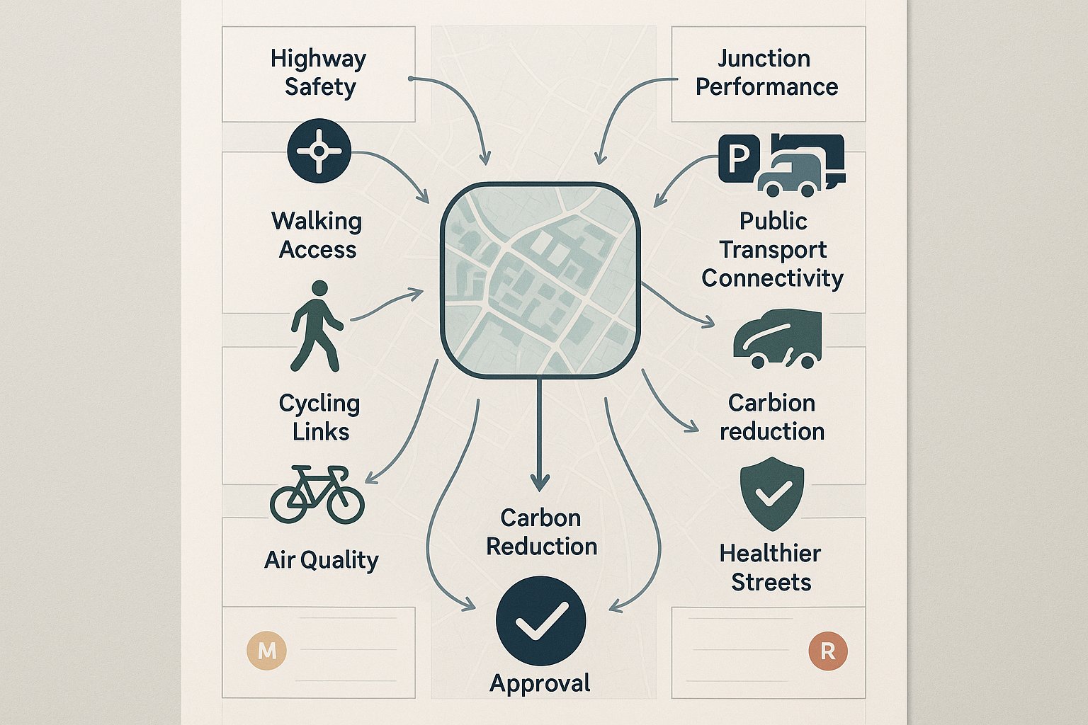
In Birmingham, transport evidence helps answer several planning questions at once. Will the proposal create a highway safety problem? Will nearby junctions operate acceptably? Is the site genuinely accessible by non-car modes? Does the parking and servicing strategy fit the urban context? And does the scheme align with wider public policy on air quality, carbon reduction and healthier streets?
Those points are not abstract. They influence application timescales, planning conditions, Section 106 discussions, layout revisions and, sometimes, whether a scheme is supported at all. A weak access strategy or an over-car-dependent design can undermine an otherwise well-prepared application.
This is especially true in a city that is actively reshaping movement patterns. Birmingham’s planning environment increasingly rewards schemes that make realistic provision for walking, cycling and public transport, while being more sceptical of assumptions based on unrestricted private car use.
For project teams, the value of good transport planning lies in clarity. It tells us what evidence is needed, where risks are likely to arise, and what mitigation or design changes should be made before the application is submitted. Done well, it reduces uncertainty rather than adding paperwork.
How Birmingham’s Planning Context Shapes Transport Requirements
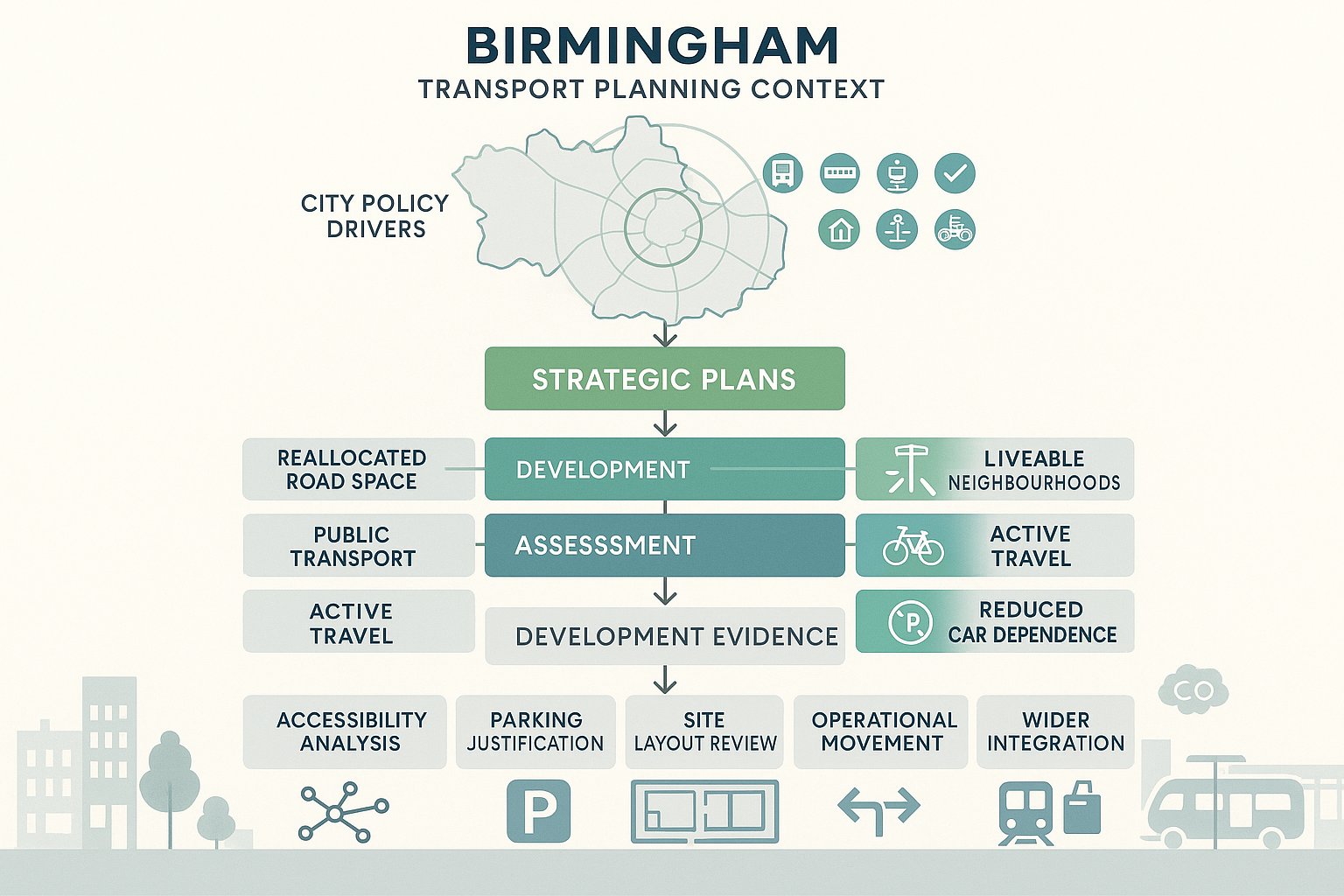
Birmingham has a distinct policy context, and it materially affects what local transport evidence needs to show. The city’s strategic direction is strongly influenced by the Birmingham Transport Plan 2031, which promotes a reallocation of road space, more liveable neighbourhoods, greater priority for active travel and public transport, and active management of demand for car travel.
That matters because transport reports are judged against those objectives, not in isolation. A proposal may technically accommodate vehicles, but if it does so in a way that conflicts with local ambitions on mode shift, street quality or parking restraint, officers may still raise concerns.
Alongside the transport plan, the Birmingham Development Plan and wider West Midlands policy framework reinforce the same broad themes. TfWM and WMCA strategies continue to push schemes toward better integration with bus, rail, Metro, cycling infrastructure and walkable local centres. The Clean Air Zone and other corridor or area-based interventions also form part of the live planning context.
So, when we prepare transport planning Birmingham evidence, we are not simply testing traffic impact. We are showing how a development responds to a city that is intentionally moving away from car-dominated growth patterns.
That usually affects the scope of work, the level of justification needed for parking, the emphasis placed on accessibility analysis, and the scrutiny given to site layout and operational movement.
Key Local Policy And Decision-Making Factors To Consider
Key Local Policy And Decision-Making Factors To Consider
Several recurring factors tend to shape transport responses from Birmingham planning and highways officers.
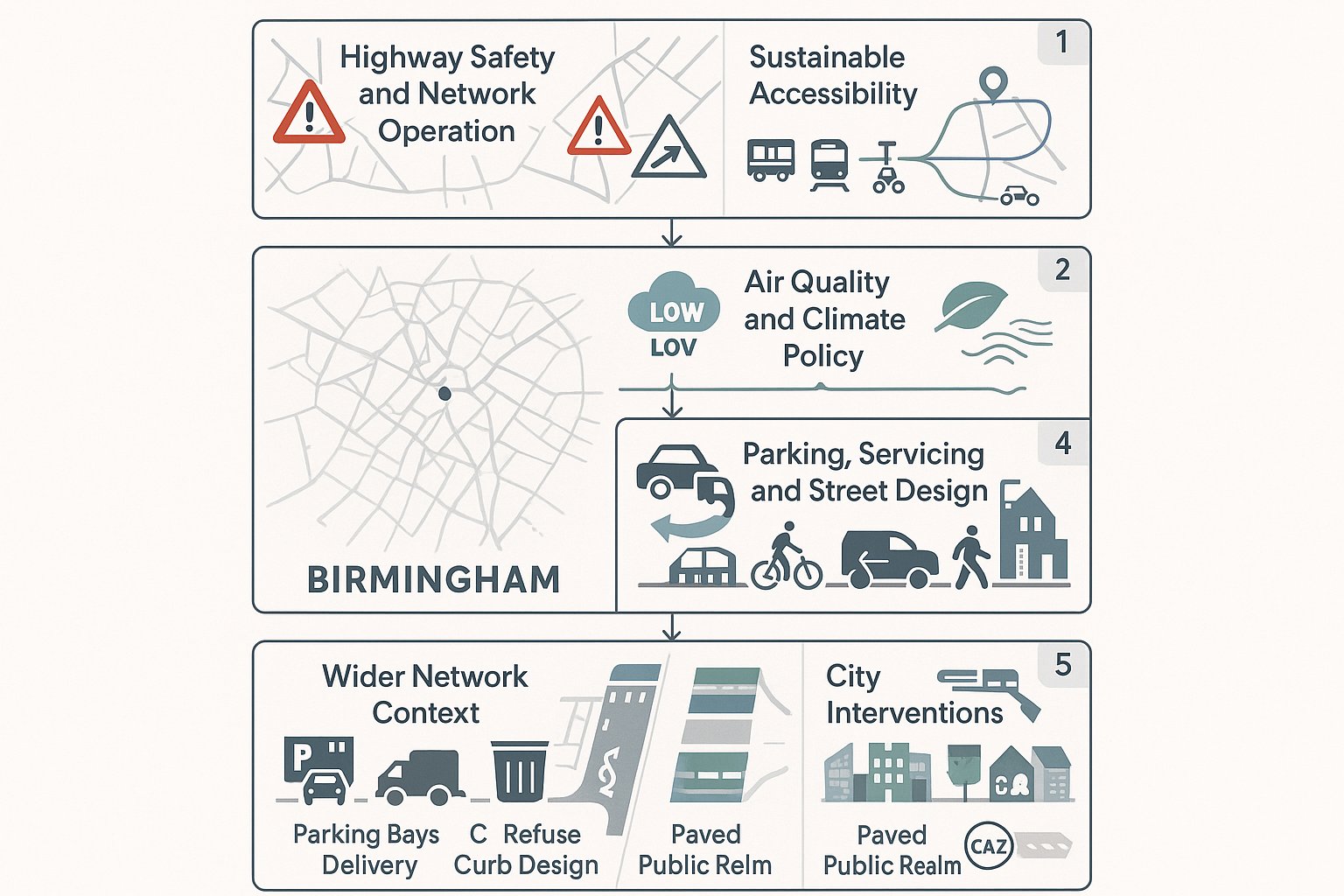
First, highway safety and network operation remain fundamental. Site access design, visibility, pedestrian crossing arrangements and the effect on nearby junctions are all core considerations. Even relatively small schemes can attract detailed comment where the surrounding network is constrained.
Second, sustainable accessibility carries real weight. Officers will look closely at whether people can reach the site by bus, rail, tram, on foot or by cycle, and whether those routes are realistic rather than theoretical. A bus stop on a plan is one thing: a safe, legible route to it is another.
Third, air quality and climate policy increasingly sit within transport discussions. Birmingham’s broader environmental commitments mean transport submissions should not ignore mode shift, emissions implications and the wider benefits of reducing private car dependency.
Fourth, parking, servicing and street design compliance can become decisive. Excessive parking, awkward servicing manoeuvres, poor refuse access or conflict with pedestrians and cyclists often trigger redesign requests.
And finally, there is the issue of fit with wider transport interventions. Existing or emerging bus priority, cycle routes, public realm changes and Clean Air Zone-related movement patterns can all influence how a scheme is viewed. In short, local context is not background noise: it is the frame through which transport impacts are assessed.
When A Transport Assessment, Transport Statement, Or Travel Plan Is Needed
The right level of transport documentation depends on the scale of development, the sensitivity of the surrounding network and the policy context of the site. There is no single Birmingham-only trigger list that answers every case neatly, so professional judgement matters.
Broadly, a Transport Assessment (TA) is expected for larger or more traffic-intensive proposals where there may be material effects on junction capacity, safety, servicing or travel patterns. That often includes major residential schemes, larger student accommodation, retail, employment and leisure uses.
A Transport Statement (TS) is usually suitable where impacts are more limited and can be addressed without detailed modelling. It still needs to be robust. “Smaller” does not mean superficial, particularly on constrained urban sites.
A Travel Plan is commonly required for major development and for uses where mode shift is a planning objective in its own right. Offices, schools, healthcare, larger residential schemes and mixed-use developments often fall into that category.
In Birmingham, the policy emphasis on reducing car dependence means some schemes need more transport evidence than applicants first assume. A site near a busy corridor, within an area of active network change, or close to sensitive junctions may justify a fuller assessment even where the development itself looks relatively modest on paper.
That is why early scoping with experienced transport planners is so useful. It helps us avoid both under-preparation and over-complication.
Choosing The Right Level Of Transport Evidence For A Scheme
Choosing The Right Level Of Transport Evidence For A Scheme
Choosing between a TA, TS and supporting Travel Plan should be a reasoned exercise, not a guess based on application type alone.
We usually start with four questions:
- How many trips is the scheme likely to generate?
- How sensitive is the local network?
- How sustainable is the location in practice?
- What does policy expect in this part of Birmingham?
For example, a modest urban infill scheme in a highly accessible location may only need a concise statement if trip generation is low and there are no obvious operational issues. But a similar-sized proposal near a constrained junction, school frontage or busy district centre might need more detailed analysis.
The same applies to mode share assumptions. Birmingham’s transport-first policy direction means reports should be realistic but also properly calibrated to location. We cannot simply import generic suburban car mode assumptions into a central or highly accessible site and expect them to pass without challenge.
The proportional approach is the right one. Use enough evidence to answer the actual planning risks. That might include TRICS-based trip forecasting, collision analysis, swept-path tracking, accessibility mapping, junction modelling, parking accumulation, Delivery and Servicing considerations, or a full Travel Plan framework.
The key is defensibility. If the scope is too light, officers may ask for more and the application slows. If it is right-sized from the start, the process tends to move more cleanly.
Common Development Types That Trigger Transport Planning Input
Some development types attract transport scrutiny more consistently than others, either because they generate noticeable trips or because their movement patterns create peaks, servicing complexity or safety concerns.
Residential schemes are an obvious example, especially medium to large housing sites, apartment blocks and student accommodation. Questions typically focus on trip generation, parking levels, access geometry, refuse collection, cycle parking and how residents will travel without relying too heavily on the private car.
City centre and district centre offices, retail and leisure uses also commonly require transport input. These uses can have highly location-sensitive travel patterns. In accessible areas, officers may expect lower parking provision and a strong emphasis on walking, cycling and public transport.
Education and healthcare developments often need careful assessment because of concentrated peak movements, drop-off activity, safeguarding issues and a strong policy expectation for Travel Plans. Schools in particular can create localised network stress even where total daily trips are not especially high.
Stadia, arenas and other event-led uses bring a different challenge: intermittent but intense movement peaks, crowd management and multimodal access planning.
Then there are logistics, warehousing, industrial and roadside formats such as drive-thrus. These can raise HGV routing, servicing, stacking, turning, access safety and operational efficiency issues.
In short, transport planning is not only for very large schemes. It is needed wherever movement impacts, access design or policy alignment could become material planning issues.
What A Birmingham Transport Assessment Typically Covers
A good Birmingham Transport Assessment does more than present traffic numbers. It builds a structured case that the development is accessible, operationally sound and acceptable in planning terms.
Typically, it starts with a policy review. That should cover the Birmingham Transport Plan, relevant local plan policies, parking and design guidance, and any area-specific transport interventions that could affect the site.
Next comes the baseline position. This usually includes the surrounding highway network, existing access arrangements, traffic conditions, collision history, nearby junction performance, walking and cycling links, bus services, rail or Metro access, and the general accessibility profile of the location.
The report then addresses development proposals and movement characteristics: what is being built, how many units or how much floorspace is proposed, where access will be taken, how parking and servicing will work, and what the likely travel demand will be.
From there, the assessment moves into forecasting and impact analysis. Depending on the scheme, that may involve trip generation, trip distribution, assignment, junction modelling and cumulative impact review.
It should also cover sustainable travel measures, parking and servicing arrangements, and where relevant construction traffic and phasing. For major schemes, a framework or full Travel Plan often sits alongside the assessment.
The best reports are concise but not thin. They anticipate the questions officers are likely to ask and answer them clearly, with drawings and evidence that tie together rather than contradict each other.
Trip Generation, Distribution, And Junction Impact
Trip Generation, Distribution, And Junction Impact
This is often the part of a Transport Assessment that receives the closest technical scrutiny.
Trip generation should normally be based on recognised evidence, commonly TRICS, with careful filtering and transparent assumptions. In Birmingham, mode share is especially important. Car driver rates, public transport usage and walking or cycling potential need to reflect the character of the site, not simply industry averages lifted without context.
Trip distribution and assignment should then show where movements are likely to come from and go to. Depending on the scheme, this might draw on census travel-to-work data, local journey patterns, gravity-based logic, committed development information and professional judgement about the surrounding road hierarchy.
The resulting flows are used to test junction and corridor impacts, usually in agreed peak periods. Some sites need only a high-level review: others require PICADY, ARCADY, LinSig, VISSIM or other modelling approaches, depending on the nature of the network and the concerns raised.
The purpose is not to prove that a scheme has zero impact. That is rarely realistic. The question is whether the residual cumulative effect would be severe in National Planning Policy Framework terms, and if not, what mitigation is proportionate.
That mitigation might include access redesign, signal optimisation, pedestrian crossing upgrades, wayfinding, cycle provision, Travel Plan measures or adjustments to parking and servicing. Good analysis is not about producing more spreadsheets. It is about getting to a workable, credible solution.
Sustainable Travel, Accessibility, And Active Travel Expectations
In Birmingham, sustainable travel is not a side chapter added at the end of a report. It is central to whether a proposal aligns with local policy.
Applicants are increasingly expected to demonstrate that a site is genuinely accessible by walking, cycling and public transport, and that the development actively supports those modes. That means looking beyond straight-line distances. We need to assess route quality, crossing points, lighting, severance, gradients, step-free access, personal safety and how intuitive the journey feels.
For walking, officers will often focus on links to local centres, schools, healthcare, public transport stops and nearby services. For cycling, secure and convenient parking matters, but so does connection to usable routes. A cycle store tucked away in a basement does not, by itself, make a development cycle-friendly.
Public transport analysis should consider not just proximity to bus, rail or tram services, but frequency, destinations and how people actually reach them. Where accessibility is weaker, the package may need to include contributions, shuttle arrangements, infrastructure upgrades or stronger Travel Plan measures.
This is where Birmingham’s strategic direction is very clear. The city wants development to support mode shift and healthier movement patterns. So the transport narrative needs to show more than compliance. It should explain how the scheme helps reduce unnecessary car reliance and fits with the wider ambition for more liveable streets and centres.
Parking, Servicing, Refuse Collection, And Operational Access
Many planning delays are caused not by headline traffic impact, but by unresolved operational details. Parking, servicing, refuse collection and internal access need just as much attention as junction modelling.
In Birmingham, car parking provision often requires careful justification, particularly in accessible locations and in or near the city centre. Local policy generally leans toward restraint rather than generous long-stay provision. Over-providing parking can be just as problematic as under-providing it if it undermines mode shift objectives.
At the same time, the scheme still has to function day to day. That means considering disabled parking, EV charging, visitor spaces where appropriate, cycle parking for both short and long stay use, and layout geometry that works in practice rather than only on plan.
Servicing and refuse can be a flashpoint. Delivery vehicles need safe access, turning and exit arrangements. Refuse collection points need to be operationally workable. And the design should minimise conflict with pedestrians and cyclists, especially on tighter urban sites.
Swept-path analysis is often essential here. So is realism. If a service yard only works when every parked car disappears and no one is walking through it, it does not really work.
Operational access also includes emergency access, gate positions, internal circulation and whether vehicles can enter and leave in forward gear where required. These details may feel mundane. They are not. They are often the difference between a smooth validation-to-decision process and a lengthy round of amended drawings.
How To Avoid Delays In Birmingham Planning Applications
Most transport-related delays are preventable. They usually happen because the scope was agreed too late, the evidence was inconsistent, or operational issues were left unresolved until after submission.
The single best step is early pre-application engagement. That can help agree whether a TA or TS is required, what survey base is needed, which junctions should be assessed, what peak periods matter, and whether modelling will be expected. It also gives project teams a chance to test emerging access and parking ideas before they become fixed in the design.
Applications also move more smoothly when the transport package is coherent. The site layout, planning drawings, Design and Access material, drainage strategy, refuse proposals and transport report all need to tell the same story. Contradictions are surprisingly common, and officers spot them quickly.
Another frequent cause of delay is failing to reflect local policy language and priorities. A generic national report may tick technical boxes but still miss what Birmingham actually cares about: mode shift, active travel, parking restraint, safer streets and fit with wider transport interventions.
Finally, there is timing. Traffic surveys, modelling, design iterations and officer dialogue all take time. If transport work starts after the architectural layout is effectively locked, it often becomes a salvage exercise. Start early, and it can shape a better scheme instead.
Frequent Issues Raised By Highways And Planning Officers
Frequent Issues Raised By Highways And Planning Officers
Certain comments come up again and again on Birmingham applications.
One is understated trip generation. If the assumptions appear too optimistic, especially for car restraint, officers may question the whole evidence base. The issue is not whether lower car use is possible: it is whether the report has justified it properly for that specific site.
Another is weak active travel provision. Poor pedestrian routes, inconvenient cycle parking, missing crossings or limited connection to public transport can all undermine the transport case, even where highway impact is modest.
Parking strategy is another regular pressure point. Over-supply, awkward layout, poor disabled provision, inadequate cycle storage or unclear management arrangements can trigger objections or requests for revision.
Officers also commonly raise site access safety concerns: visibility, turning movements, conflict with vulnerable road users, servicing manoeuvres and impacts on nearby junctions.
And then there is a more general issue, lack of integration. Sometimes the TA says one thing, the drawings show another, and the Travel Plan promises a third. That kind of disconnect creates doubt very quickly.
A careful, locally informed transport review before submission can catch most of these points. It is much cheaper to fix them on a draft than in response to formal consultation comments.
Working With Transport Planners Early To Strengthen An Application
Early transport planning input nearly always improves the quality of a Birmingham planning application. It helps shape the scheme, not just explain it after the fact.
When transport planners are involved at concept stage, we can test access options, advise on parking levels, flag servicing constraints, assess whether a basement or courtyard layout will actually work, and identify where policy risks are likely to arise. That can save redesign time later and prevent the common problem of a transport report having to defend a layout that was never operationally robust.
Early involvement also makes pre-application discussions more productive. A clear, proportionate transport strategy gives officers something concrete to respond to, which often leads to a more focused scope and fewer surprises at submission stage.
For multidisciplinary teams, this matters. Architects, planning consultants, lawyers, surveyors and developers all benefit when transport issues are clarified early, because they affect viability, land take, unit numbers, public realm, conditions and obligations.
At ML Traffic, that is exactly where concise, accurate reporting adds value. With more than 30 years of experience, our role is not to overcomplicate matters. It is to prepare transport evidence that fits the local authority context, addresses the real planning risks and helps move applications forward.
In Birmingham, that early, practical approach is often what turns transport from a potential obstacle into part of the case for approval.
Transport Planning Birmingham – Frequently Asked Questions
What is the importance of transport planning for developments in Birmingham?
Transport planning in Birmingham is critical for ensuring developments are acceptable in terms of highway safety, congestion, air quality, and accessibility. It directly affects planning permission, viability, and how well a scheme integrates with the city’s transport and environmental policies.
When is a Transport Assessment or Transport Statement required for Birmingham planning applications?
A Transport Assessment (TA) is usually needed for larger or traffic-intensive developments like major residential, retail, and leisure schemes, while a Transport Statement (TS) suits smaller proposals with limited impacts. The requirement depends on trip generation, network sensitivity, site location, and policy expectations.
How does Birmingham’s local policy influence transport planning requirements?
Birmingham’s transport planning is shaped by the Birmingham Transport Plan 2031 and other local and regional strategies, prioritising walking, cycling, and public transport while reducing car dependence. Transport evidence must demonstrate alignment with air quality goals, parking restraint, sustainable travel, and network safety to gain approval.
What key factors do Birmingham planning officers focus on when reviewing transport plans?
Officers assess highway safety, network operation, sustainable accessibility by active and public transport modes, air quality impacts, parking and servicing design, and the scheme’s fit with wider transport interventions like Clean Air Zones and bus or cycle priority routes.
How can early engagement with transport planners benefit Birmingham planning applications?
Early involvement helps set the right scope for assessments, identify operational and policy risks, optimise access and parking strategies, and ensure the transport evidence is coherent and aligned with local priorities, reducing delays and increasing the likelihood of approval.
What sustainable travel measures are expected in Birmingham development proposals?
Proposals should demonstrate high-quality, safe walking and cycling connections, good public transport accessibility, secure cycle parking, and measures encouraging mode shift away from private cars, supporting Birmingham’s goals for healthier streets and carbon reduction.