A planning application can rise or fall on transport. Not because transport is always the headline issue, but because it often becomes the point where design ambition meets real-world scrutiny: can people get in and out safely, will the local road network cope, is parking workable, and does the scheme support sustainable travel rather than simply adding more car dependency?
That’s exactly why Transport Planning in Durham needs to be handled carefully. Across County Durham, transport evidence sits within a clear policy framework shaped by the National Planning Policy Framework, the County Durham Plan, local highway standards, and the practical expectations of Durham County Council as highway authority. Whether we’re advising on a housing site, a roadside commercial unit, a school expansion or a mixed-use scheme, the same principle applies: the transport case must be proportionate, technically sound, and tailored to the site.
In our experience, the strongest submissions aren’t the longest. They’re the ones that answer the right questions early, use robust survey evidence, and align design, planning and highways thinking from the outset. That’s where concise technical reporting really matters.
This guide sets out what transport planning in Durham covers, when transport evidence is likely to be required, which documents are commonly needed, and how we can prepare a submission that gives planning applications the best possible footing in 2026.
What Transport Planning In Durham Covers And Why It Matters
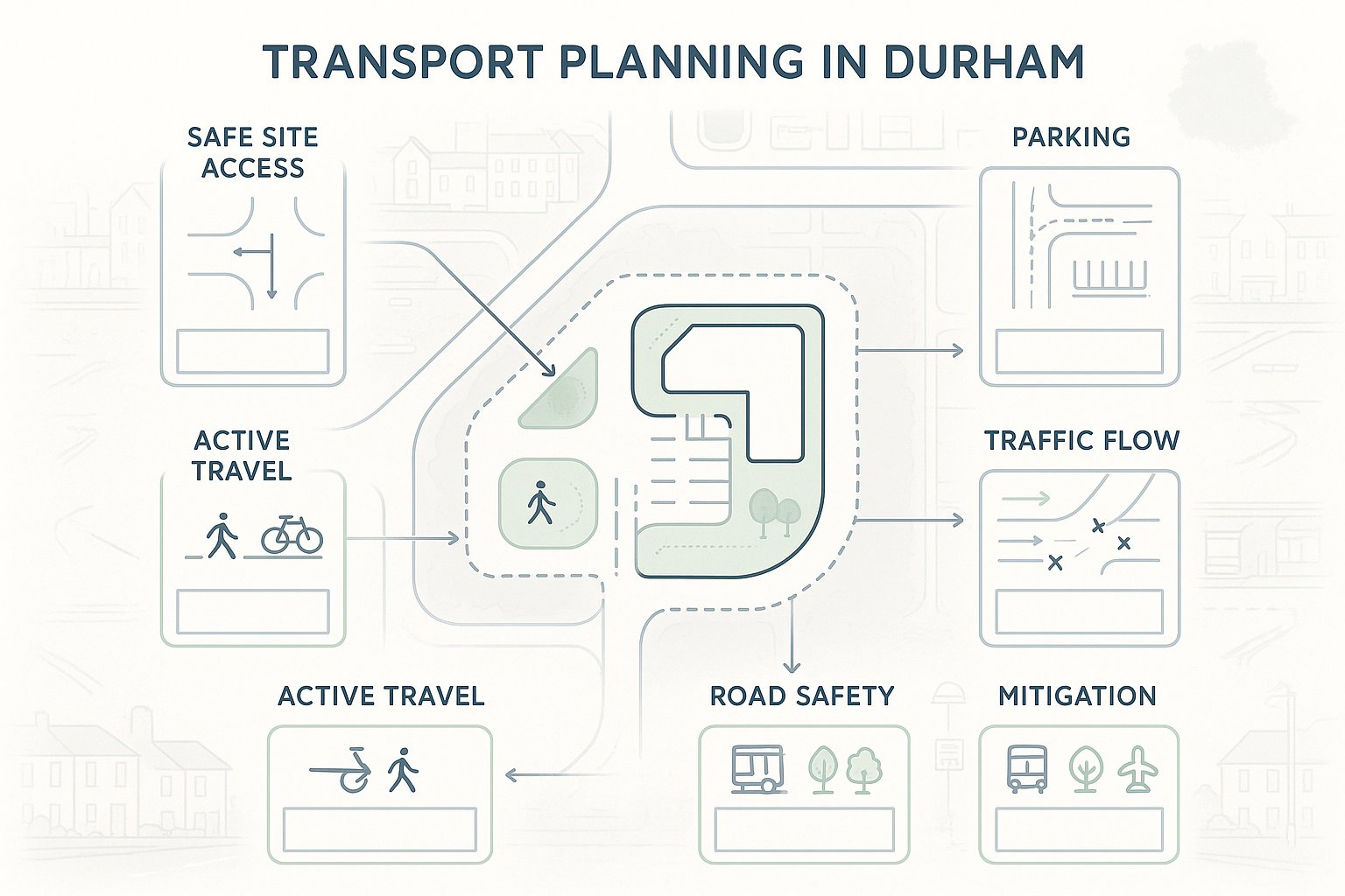
Transport planning in Durham is wider than a single traffic report attached at the end of an application. It covers how a development connects to the surrounding highway network, how people arrive on foot, by cycle, bus or car, how deliveries and refuse vehicles operate, and what effect the proposal may have on nearby junctions and streets.
In practical terms, that usually means reviewing six recurring themes:
- Access and highway safety
- Parking, turning and servicing
- Trip generation and traffic impact
- Walking, cycling and public transport links
- Road safety and collision history
- Mitigation and sustainable travel measures
Why does it matter so much? Because transport evidence goes directly to policy compliance. The planning system is looking for safe and suitable access for all users, realistic travel choices, and impacts that are not severe in NPPF terms. A scheme that ignores these points can quickly run into objections from highways officers, planning officers, members, or local residents.
And there’s a commercial angle too. Weak transport planning often leads to redesign, delayed validation, extra technical queries and avoidable negotiation late in the process. Strong transport planning, by contrast, helps us shape the scheme before positions harden.
For applicants, that can mean fewer surprises. For design teams, it means clearer constraints. For local councils, it means decisions can be made on evidence rather than assumption. That’s why transport planning is rarely just a supporting document: in many Durham applications, it’s one of the central tests of whether development is genuinely deliverable.
How Durham’s Planning Context Shapes Transport Requirements
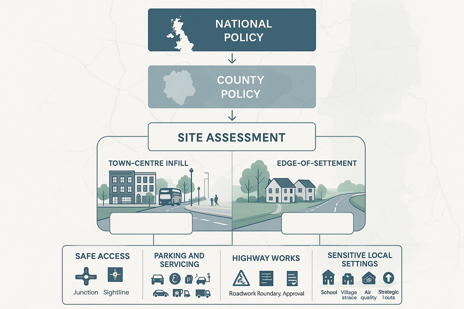
Durham’s planning context matters because transport requirements are never assessed in a vacuum. A small infill site near a town centre bus corridor will not be judged in the same way as a larger edge-of-settlement housing site served from a constrained rural road. The policy framework sets the principles, but local context decides how those principles are applied.
At national level, the starting point is the National Planning Policy Framework (NPPF). In transport terms, that means development should provide safe and suitable access for all users, focus on sustainable movement, and only be refused on highways grounds where the residual cumulative impacts are severe. That word, severe, gets quoted often, but in practice it depends on evidence, not rhetoric.
Locally, the County Durham Plan adds a more specific layer. Its policies on transport, design quality, parking, climate and air quality all shape what supporting evidence is needed. Durham County Council will usually expect transport documents to reflect the nature of the site, the scale of development, nearby receptors such as schools or local centres, and the quality of existing walking, cycling and bus connections.
This is where local knowledge makes a difference. A report that simply repeats generic national policy rarely carries much weight. One that responds to the character of Durham’s roads, settlement pattern, public transport availability and local standards is far more persuasive.
County Durham Policy Expectations And Local Highway Considerations
In County Durham, transport review often comes down to a set of practical local questions.
First, can the access work safely? That includes visibility splays, geometry, gradients, pedestrian crossing points and the relationship with nearby junctions. On rural or semi-rural sites, speed surveys and a careful understanding of roadside conditions can be critical.
Second, does the parking and servicing arrangement reflect local expectations? Durham applications are commonly scrutinised for car parking levels, disabled spaces, EV provision, cycle parking, delivery access, refuse collection and turning. Underprovided parking can trigger overspill concerns: overprovided parking can undermine sustainable objectives.
Third, are works needed within the public highway? If so, Section 278 or Section 38 implications may need to be considered early. That can affect cost, programme and design coordination.
Finally, Durham’s local network includes sensitive locations: town centres, school frontages, air quality pressure points, strategic routes and villages with limited footway provision. Those settings can elevate the need for detailed evidence even where a scheme might look modest on paper. In other words, transport requirements are shaped as much by where a site sits as by how many units or square metres it proposes.
When A Development In Durham Is Likely To Need Transport Evidence
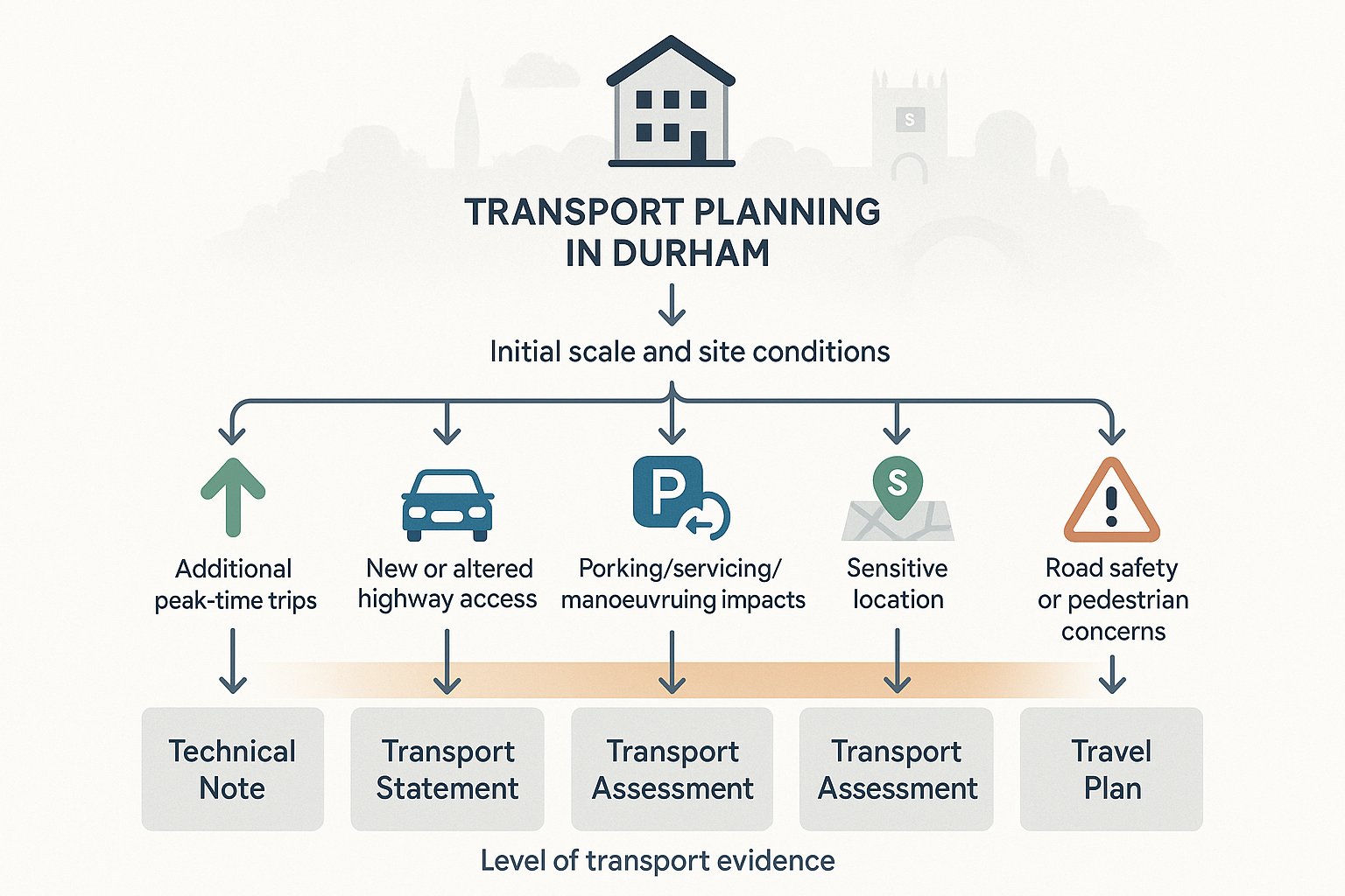
Not every development in Durham needs a full Transport Assessment. But many schemes do require some level of transport evidence, and one of the most common mistakes is assuming that “small” automatically means “simple”. A modest proposal can still raise real highway concerns if it changes access, intensifies parking demand or sits on a constrained route.
As a rule, transport evidence is likely to be needed where development would:
- create material additional trips, especially in peak periods:
- alter or introduce an access onto the public highway:
- affect parking, servicing or manoeuvring:
- sit in a sensitive location, such as near a school, on an A-road, close to a town centre, or within an area with existing congestion or air quality pressures:
- generate concern around road safety, visibility or pedestrian movement.
The form of evidence depends on scale and risk. Some schemes need only a focused note on access and parking. Others need a full assessment with traffic forecasts, junction modelling and a Travel Plan.
In our work, the key is proportionality. Highway authorities generally respond well when the scope clearly matches the development. Too little evidence creates obvious gaps. Too much can bury the important points under unnecessary detail. The aim is a robust submission that answers likely questions before they are asked.
Common Triggers For Transport Statements, Assessments, And Travel Plans
A Transport Statement (TS) is commonly used for smaller to medium schemes where impacts are noticeable but not expected to be severe. That might include modest residential development, smaller commercial schemes, or change-of-use proposals where access, parking and local trip effects need to be reviewed.
A Transport Assessment (TA) is more likely where proposals are larger or where the network is already sensitive. As a broad guide, schemes of around 80–100 dwellings or more, or 1,000+ m² of employment, retail or similar floorspace, often move into TA territory. But thresholds are not mechanical. A smaller scheme can still justify a TA if it affects a constrained junction or a difficult access.
A Travel Plan (TP) is typically expected for major residential, education, healthcare, employment and other higher trip-generating development. In Durham, Travel Plans matter because they show how sustainable travel will be encouraged in practice rather than simply referenced in principle.
Then there are Technical Notes. These can be invaluable where the issue is narrow: a parking stress review, a visibility justification, a speed survey note, or a response to officer comments. Used well, they can solve a specific concern without reopening the whole transport case.
Key Transport Planning Documents Used For Durham Applications
Most Durham planning applications involving transport evidence rely on a relatively small set of core documents. The challenge isn’t choosing from dozens of options: it’s selecting the right level of reporting and making sure each document does a clear job.
At a glance, the main documents are:
- Transport Statement
- Transport Assessment
- Travel Plan
- Technical Note or supporting addendum
Each serves a different purpose, and confusion between them can slow an application down. A planning team may assume a brief statement is enough, while the highway authority may be expecting multi-modal analysis and junction modelling. That gap is avoidable if scope is agreed early.
For sites in Durham, the strongest approach is usually to treat these documents as part of one evidence package rather than isolated reports. The transport narrative should be consistent throughout: the access strategy, parking approach, trip assumptions, sustainable travel measures and mitigation should all point in the same direction.
That sounds obvious, but it is surprisingly common to see discrepancies between site layout plans, drainage drawings, refuse tracking, and the transport report. Once that happens, objections multiply. Good transport planning is partly technical competence and partly disciplined coordination.
Transport Statements, Transport Assessments, Travel Plans, And Technical Notes
A Transport Statement is a proportionate report. It normally covers existing site conditions, access proposals, parking and servicing, likely trip generation, sustainable travel opportunities and, where needed, a light-touch review of nearby junctions. For many smaller schemes, that is enough.
A Transport Assessment goes further. It typically includes baseline transport conditions, committed development review, forecast trip generation and distribution, junction capacity analysis, road safety review, accessibility audit, and mitigation proposals. In Durham, a TA should be evidence-led and transparent about assumptions, especially where development traffic is being tested against constrained links or junctions.
A Travel Plan sets out how the development will reduce reliance on the private car and encourage walking, cycling, public transport, car sharing and other sustainable choices. A credible Travel Plan includes targets, measures, monitoring, timescales and a responsible coordinator, not just a list of good intentions.
A Technical Note is often the most efficient tool when one issue needs focused attention. It can clarify a modelling assumption, respond to consultee comments, justify parking provision, or provide a specific piece of supplementary analysis. For applicants, that flexibility is useful: for planning officers, it can make technical questions much easier to resolve.
Core Issues Reviewed In A Durham Transport Assessment
A Durham Transport Assessment is not simply about counting cars. It is a structured examination of how a proposal fits into its surroundings, how safely and efficiently it can operate, and whether any mitigation is needed to make the impacts acceptable.
Most assessments are built around the same core strands: site access, internal layout, parking, servicing, trip generation, distribution, junction performance, sustainable travel, and road safety. The exact depth depends on the proposal, but the logic stays consistent, understand baseline conditions, forecast change, then test whether the development works.
The quality of this analysis matters because transport objections rarely arise from one dramatic flaw. More often, concern builds through several smaller weaknesses: an access that feels tight, parking that looks marginal, a junction model with unexplained assumptions, or a Travel Plan that reads as boilerplate. A solid TA removes those weak points.
For Durham sites, there is also a strong local dimension. Urban sites may raise questions about congestion, pedestrian movement and parking stress. Rural sites often bring visibility, speed environment and limited non-car travel options into sharper focus. So while the report structure may be familiar, the evidence needs to be site-specific.
Access, Parking, Servicing, Visibility, Trip Generation, And Network Impact
Access is usually the first test. We need to show that the proposed point of access is appropriately located, can accommodate expected vehicle types, and provides safe movement for pedestrians, cyclists and drivers. That may involve visibility splay drawings, swept-path analysis, gradient checks and commentary on junction form.
Parking and servicing come next. Durham applications are typically reviewed for car parking numbers, disabled bays, EV charging, cycle parking, delivery arrangements, refuse collection and turning. Internal layout matters just as much as quantity: a cramped parking court or awkward servicing area can undermine an otherwise acceptable proposal.
Visibility is especially important where sites front roads with higher traffic speeds, bends, vertical alignment issues or roadside vegetation. In those cases, speed surveys and a realistic view of observed conditions can become central to the application.
Trip generation and distribution are commonly derived from TRICS, then refined where local context justifies it. The important thing is not just producing numbers but explaining them persuasively.
Finally, network impact is assessed through junction modelling or qualitative review, depending on scale. Tools such as PICADY, ARCADY and LINSIG may be used to test queueing, delay and reserve capacity. If problems arise, the assessment should identify workable mitigation rather than simply describing the issue and stopping there.
Sustainable Travel And Accessibility Expectations In Durham
Transport planning in Durham is not limited to vehicle access. Increasingly, applications are expected to show how a site supports walking, cycling and public transport in a meaningful way. That is partly a policy issue, but it is also a practical one: sustainable travel only carries weight when the routes, facilities and local connections are genuinely usable.
The expectation across Durham is fairly clear. Development should minimise unnecessary car dependency, connect safely to local facilities, and provide infrastructure that supports everyday trips by foot, cycle or bus. For some sites, especially in or near built-up areas, that means demonstrating strong links to schools, shops, employment areas and public transport corridors. For more peripheral sites, it means being honest about constraints and showing what reasonable mitigation can still be achieved.
Typical benchmarks often include walk distances of roughly 400–800 metres to bus stops and local facilities, and cycle catchments of around 5 km for many routine trips. Those aren’t rigid pass-fail lines, but they are useful indicators when assessing how accessible a site really is.
Done properly, accessibility analysis can strengthen the whole planning case. It shows that transport planning is not just about accommodating traffic: it is about shaping travel behaviour over time.
Walking, Cycling, Public Transport, And Site Connectivity
For walking, Durham applications should consider whether footways are continuous, crossing points are safe, gradients are manageable, lighting is adequate and routes feel direct rather than theoretical. A route that exists on a plan but involves narrow verges, poor crossing opportunities or hostile traffic conditions will not carry much persuasive force.
For cycling, the key questions are whether people can reach local destinations safely, whether cycle parking is secure and convenient, and whether the development links into existing or planned active travel routes. On some sites, a small off-site connection or dropped kerb can make a disproportionate difference.
For public transport, proximity alone is not enough. We should assess the quality of the route to bus stops or stations, service frequency, likely destinations, and whether the timetable supports realistic day-to-day journeys.
Then there is site connectivity overall. This is where transport planning often overlaps with urban design. Good permeability, overlooked walking routes, convenient cycle storage, and legible links to surrounding streets all help make sustainable travel credible. If a scheme is designed around the car from the outset, no amount of wording in a Travel Plan will fully disguise it.
How To Prepare A Strong Transport Submission For A Durham Site
A strong transport submission is rarely produced by reacting late. The best results usually come when transport planning starts early enough to influence site design, not just justify it afterwards. That matters in Durham because many highway concerns, visibility, access geometry, parking pressure, servicing conflicts, poor walk links, are much easier to solve on a drawing board than during a planning appeal or post-submission negotiation.
For applicants, we usually think in four stages: understand the site, collect the right evidence, develop the design iteratively, and engage early with the authority where appropriate. This creates a cleaner technical narrative and reduces the risk of contradictory information appearing across reports and plans.
It is also where specialist input can save time. On complex or time-sensitive applications, concise and accurate reporting is worth a lot more than a bulky document delivered too late. That is one reason firms such as ML Traffic are often brought in early: local-authority-aware advice tends to prevent avoidable rework.
Site Appraisal, Survey Data, Design Development, And Early Authority Engagement
A robust submission starts with site appraisal. We need to understand the surrounding road hierarchy, existing access conditions, speed environment, collision history, nearby schools or sensitive receptors, parking conditions and the location of everyday facilities. This stage often reveals whether the main issue is network capacity, access design, parking, sustainability, or a combination of several.
Next comes survey data. Depending on the site, that may include classified turning counts, queue surveys, automatic traffic counts, speed surveys, parking beat surveys, pedestrian and cycle counts, and public transport information. Out-of-date or poorly targeted surveys can weaken an otherwise good report, so scoping them properly matters.
Then comes design development. Access arrangements, swept paths, refuse collection, cycle parking, drainage features and internal road geometry need to be coordinated rather than designed in silos. We often find that small layout changes at this stage remove the need for bigger mitigation later.
Finally, early authority engagement can be extremely valuable. Pre-application discussion with Durham County Council can help agree the study area, survey scope, whether a TS or TA is needed, and what level of modelling or Travel Plan detail is expected. That does not guarantee agreement, of course, but it usually makes the application process more predictable.
If there is one consistent lesson, it is this: the strongest transport submissions are clear, proportionate, evidence-led and site-specific. That combination gives planning applications in Durham a much better chance of moving forward without unnecessary friction.
Strong transport planning in Durham is eventually about credibility. When the access works, the survey evidence is sound, the assumptions are transparent, and the sustainable travel case is realistic, the planning application stands on firmer ground.
For architects, planners, developers, lawyers and local councils, that means fewer technical surprises and a clearer path through determination. And for applicants, it often means something even more valuable: confidence that the scheme is not just policy-compliant on paper, but genuinely workable in the real world.
In 2026, that practical credibility matters more than ever. Durham’s planning context is not becoming simpler, and highway scrutiny is not getting lighter. So the winning approach is straightforward: start early, scope the evidence properly, tailor it to the site, and make sure the transport story holds together from first drawing to final submission.
Transport Planning in Durham: Frequently Asked Questions
What does transport planning in Durham typically cover and why is it important?
Transport planning in Durham covers highway access and safety, parking and servicing, trip generation and traffic impact, walking, cycling, public transport connectivity, and sustainable travel measures. It is important to ensure safe access, manage network capacity, reduce car dependency, improve air quality, and ensure compliance with local and national planning policies.
When is transport evidence required for a development application in Durham?
Transport evidence is usually needed when a development generates material additional trips, changes access to the public highway, affects parking or servicing, lies in sensitive locations like near schools or A-roads, or raises safety concerns. The scale and context of the development determine whether a Transport Statement, Transport Assessment, or Travel Plan is necessary.
What are the differences between a Transport Statement and a Transport Assessment in Durham?
A Transport Statement is a proportionate report for smaller to medium developments reviewing access, parking, and trip generation with limited junction analysis. A Transport Assessment is a detailed multi-modal study for larger or sensitive schemes, including baseline conditions, traffic forecasts, junction capacity modelling, road safety review, and mitigation proposals, ensuring evidence-led transport planning.
How does Durham’s planning context influence transport planning requirements?
Durham’s transport planning requirements are shaped by the National Planning Policy Framework, the County Durham Plan, and local highway standards. The approach varies with site location, scale, and local network sensitivity. For example, urban sites focus on congestion and parking stress, while rural sites emphasise access visibility and sustainable travel opportunities tailored to local conditions.
What are the key sustainable travel expectations for developments in Durham?
Developments must prioritise walking and cycling through safe, direct routes; provide secure cycle parking; ensure good connectivity to frequent public transport within 400–800 metres walking distance and 5 km cycling catchments; and demonstrate measures to minimise car dependency in support of air quality and climate objectives.
What are the best practices for preparing a strong transport submission in Durham?
Start transport planning early, conduct a thorough site appraisal, collect up-to-date survey data (traffic, speed, parking), develop access and layout designs iteratively, engage early with Durham County Council to agree scope and requirements, and prepare clear, consistent, evidence-led reports including an actionable Travel Plan to support sustainable travel and efficient highway use.