Oxford is rarely a place where transport can be treated as a planning afterthought. Even modest schemes can run into detailed questions about access, cycle provision, servicing, parking restraint, bus connectivity, and the practical reality of moving people through a tight historic street network. For architects, developers, planning consultants and local authorities, that means transport planning in Oxford often becomes one of the key workstreams in getting an application over the line.
That is not just because roads are busy. It is because the policy direction is clear. Oxford and Oxfordshire increasingly expect development to support non-polluting movement, stronger walking and cycling links, better use of public transport, and less dependence on private car travel, especially in and around the city centre. The county’s wider net-zero ambitions have only sharpened that focus.
In practice, we see the same pattern again and again: schemes succeed more smoothly when transport evidence is prepared early, scoped properly, and grounded in Oxford’s local constraints rather than generic assumptions. A submission that might feel adequate elsewhere can look thin very quickly here.
In this guide, we set out what transport planning in Oxford usually involves in 2026: the main documents, when a Transport Assessment or Transport Statement is typically needed, the local issues that shape evidence, and the common reasons transport submissions are challenged. The aim is simple, help teams prepare clearer, more robust planning support from the start.
Why Transport Planning Matters In Oxford’s Planning Environment
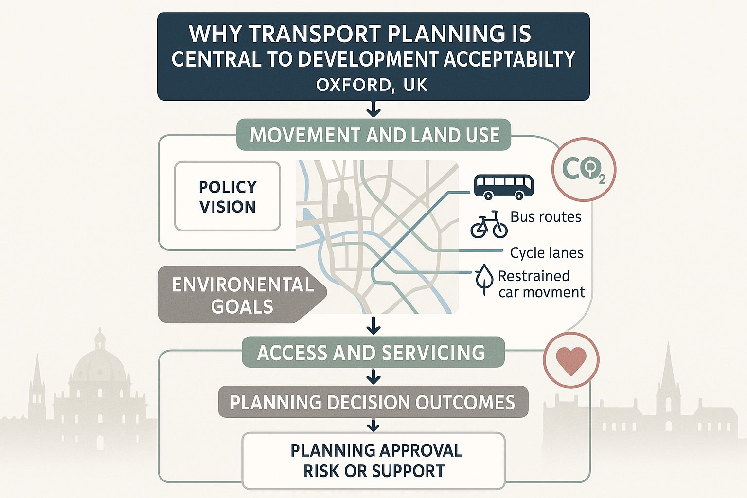
Transport planning matters in Oxford because movement, land use and environmental policy are tightly intertwined. The city is not planning for unconstrained car-led growth. Instead, the direction of travel is toward healthier streets, reduced emissions, improved public transport integration, and development patterns that make walking and cycling more realistic day to day.
That has direct planning consequences. A transport submission is not only there to answer whether junctions will cope. It also needs to show whether a proposal aligns with wider policy aims: accessibility, sustainable mode share, parking restraint, safe operation, and reasonable servicing arrangements within a constrained urban form.
Oxfordshire’s Local Transport and Connectivity Plan has reinforced this position with a net-zero transport vision. In practical terms, that raises expectations. Decision-makers are more likely to ask how a scheme supports mode shift, whether it avoids unnecessary private vehicle trips, and whether its access strategy works without pushing problems onto nearby streets.
For applicants, the key point is this: transport planning in Oxford is often central to acceptability, not a supporting appendix. A weak report can slow validation, trigger objections from highways officers, or undermine the planning balance. A well-scoped one does the opposite, it gives the design team a credible evidence base and helps show that the proposal can function in the real world, not only on a site plan.
The Main Transport Planning Documents Used In Oxford Applications
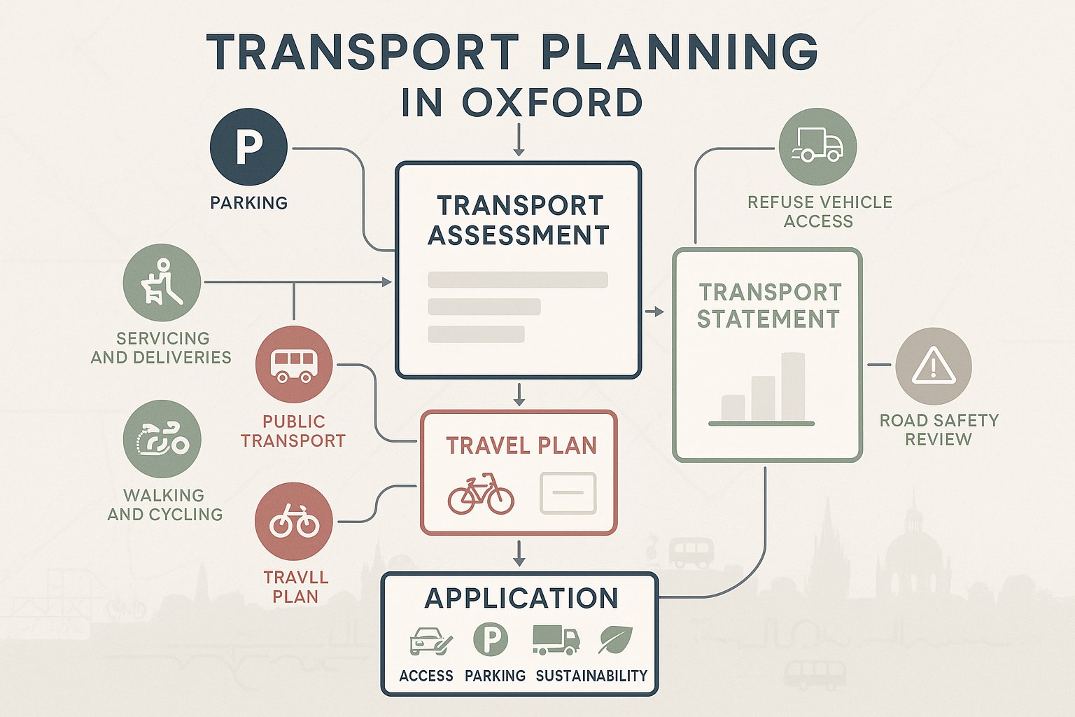
Most Oxford planning applications with transport implications rely on a familiar set of technical documents, but the exact package depends on scale, use, and site sensitivity.
A Transport Assessment (TA) is the more detailed option, generally prepared for larger or higher-impact schemes. It examines likely trip generation, distribution, network effects, access arrangements, servicing, parking, road safety, and sustainable travel opportunities.
A Transport Statement (TS) is usually used for smaller developments where impacts are expected to be more limited. It still needs to be robust, but the analysis is normally more proportionate.
A Travel Plan is also common, especially for developments that will generate regular trips, residential, student, office, education, and mixed-use schemes in particular. In Oxford, Travel Plans are often important because they show how the development will actively support walking, cycling, bus use and, where relevant, car-sharing.
Other supporting documents often matter just as much:
- parking management strategies
n- servicing and delivery plans
- refuse collection access evidence
- walking, cycling and public transport accessibility reviews
- swept path analysis for larger vehicles
- road safety or collision review information
Together, these documents explain how a scheme will operate and whether it reflects Oxford’s transport priorities. The strongest applications avoid a tick-box bundle. They make the documents work together, so access, parking, servicing and sustainability tell one coherent story.
When A Transport Assessment Or Transport Statement Is Usually Required
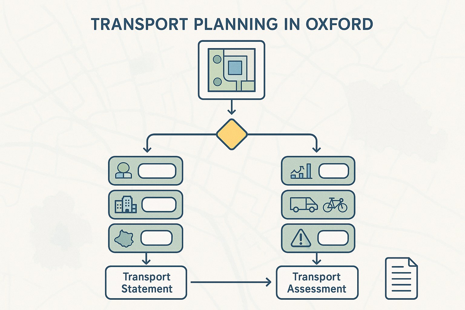
There is no single Oxford rule that says every site above a certain size must always provide the same transport document. In reality, the requirement is shaped by development scale, land use, trip intensity, location, local sensitivity and the likely effect on the surrounding network.
Broadly, a Transport Assessment is usually required where a scheme is larger, more complex, or likely to create material transport effects. That may include substantial residential development, student accommodation, commercial floorspace, schools, healthcare uses, or mixed-use schemes with notable servicing demand.
A Transport Statement is more commonly appropriate for smaller proposals where impacts are expected to be modest and can be explained proportionately. But “smaller” does not always mean “simple”. In Oxford, even relatively modest development can justify transport evidence if it sits on a constrained street, near sensitive parking controls, within a busy district centre, or in a location where access and servicing are awkward.
We usually advise clients not to think only in terms of floor area or unit numbers. Ask a more practical question: will the application invite reasonable scrutiny on access, parking, deliveries, sustainable travel, or highway safety? If yes, some form of transport submission is likely to help, and may be expected.
Early scoping with the design team is often the difference between a proportionate, targeted report and a late scramble after validation comments or consultee concerns.
How Oxford’s Local Context Shapes Transport Planning Evidence
Oxford is one of those places where local context genuinely changes the technical job. Generic transport reporting can fall flat because the city’s constraints, travel patterns and policy expectations are unusually pronounced. Evidence has to respond to how Oxford actually works on the ground, not how an unconstrained suburban site might operate elsewhere.
That means looking beyond traffic counts. In many Oxford applications, the more important questions are about accessibility, parking displacement, cycle movement, pedestrian comfort, bus links, servicing practicality and whether the development supports the city’s low-car direction of travel.
City Centre Constraints, Parking Pressure, And Street Network Limitations
The city centre and many surrounding neighbourhoods operate within obvious physical and policy limits. Streets are often narrow, historic, busy and multifunctional. The same corridor may need to serve buses, cyclists, pedestrians, loading activity, taxis, emergency access and local traffic, with very little spare space.
Parking is another regular pressure point. Even where an application is not proposing much car parking, that does not make the issue disappear. Officers and neighbours will often want to know whether overspill parking could affect nearby streets, permit-controlled areas or already stretched kerbside space. A report that shrugs this off tends to attract challenge.
Access design also needs realism. Can service vehicles enter, manoeuvre and leave safely? Is there a workable refuse strategy? Will drop-off activity block the street? In Oxford, these operational questions can be as important as classic capacity testing.
Active Travel, Public Transport, And Wider Sustainability Expectations
Oxford’s planning environment places real weight on active travel. So a transport submission should not treat walking and cycling as a brief afterthought with a map and a few distances. It should explain route quality, crossings, permeability, cycle parking standards, likely desire lines, and whether users can reach key destinations safely and conveniently.
Public transport matters too. Accessibility is not just about whether a bus stop exists nearby. We need to consider service frequency, destination coverage, journey time practicality, and how attractive the mode is for the likely users of the site.
And then there is the wider sustainability picture. Oxfordshire’s net-zero direction means assumptions around car ownership, trip rates and mode share need to feel credible in policy terms as well as technical ones. Reports that rely on generic, car-heavy patterns without local justification can feel out of step quickly. Stronger evidence shows how the proposal can contribute to a lower-car, better-connected form of development.
Key Development Types That Commonly Need Transport Input
Not every development in Oxford needs the same depth of transport work, but certain categories regularly raise transport questions early in the planning process. The common thread is simple: if the use affects trip generation, access, parking, servicing or sustainable travel expectations, transport input is usually worthwhile.
Residential, Student, And Mixed-Use Schemes
Residential schemes frequently need transport input because they bring together several issues at once: vehicle access, parking restraint, visitor parking, cycle provision, refuse collection, delivery activity and day-to-day travel patterns. In Oxford, assumptions about car ownership are often closely tested, especially in accessible locations or on low-car proposals.
Student accommodation can be particularly sensitive. Trip profiles may differ from standard housing, but that does not remove the need to assess arrivals and departures, taxi activity, servicing, cycle demand and links to university facilities, public transport and nearby amenities. The management model matters as much as the headline use.
Mixed-use schemes are often more complex again. Different uses can have different peak times, servicing needs and modal patterns. That can be a positive if internal trip capture reduces external travel, but only if the evidence is properly explained.
Commercial, Education, And Community Developments
Commercial development often raises questions around staff travel, customer access, servicing and delivery demand. For offices, the focus may be on commuter mode share and parking restraint. For retail or light industrial uses, servicing and operational access can become the dominant issue.
Education schemes, whether schools, colleges or university-related buildings, can be especially transport-sensitive in Oxford. Peak-time movement, walking routes, cycle flows, bus demand, pick-up and drop-off pressure, and safeguarding the surrounding street network all tend to matter.
Community uses can look modest on paper yet still generate concentrated transport effects. A health centre, place of worship, leisure facility or civic building may attract sharp peaks, vulnerable users, or demand for accessible parking and taxi access. In each case, the question is not whether the use is “major” in abstract terms, but how it will function in its local context.
What A Robust Oxford Transport Assessment Should Cover
A robust Oxford Transport Assessment should be proportionate, but it also needs enough depth to answer the questions local officers are likely to ask. In our experience, the best reports are structured around operation, impact and policy fit, not just traffic numbers.
At a minimum, a strong assessment will usually cover:
- Existing conditions: site context, surrounding highway layout, nearby walking and cycling links, public transport accessibility, parking controls and local constraints.
- Development proposals: land use, scale, access points, internal layout, servicing arrangements, cycle parking, refuse strategy and any mobility-related management measures.
- Trip generation and distribution: realistic assumptions based on the proposed use, local comparators and Oxford context.
- Junction and network effects: where relevant, analysis of whether the surrounding network can accommodate the development safely and efficiently.
- Parking demand and management: including disabled spaces, visitor demand, overspill risk and how any low-car strategy will work in practice.
- Servicing and deliveries: vehicle types, routing, loading arrangements, swept paths and likely operational conflicts.
- Road safety: review of local collision records and site-specific risks.
- Sustainable travel measures: walking, cycling, bus access and Travel Plan commitments.
Just as important is the quality of judgement. Oxford reports need to explain why assumptions are credible here. A spreadsheet may generate a number, but that alone will not address concerns about parking pressure on side streets, weak pedestrian routes, or an awkward service yard. The technical work has to connect with place.
Common Planning Risks And Reasons Transport Submissions Are Challenged
Transport submissions in Oxford are often challenged for predictable reasons. The pattern is familiar, and most problems are avoidable if they are identified early.
One common issue is underestimating parking pressure. A proposal may claim low car ownership or limited demand, but if the evidence is thin, or if surrounding streets are already under stress, that argument can unravel fast. Officers tend to want a realistic account of what residents, staff, visitors and contractors will actually do.
Another weak spot is poorly justified access or servicing. A scheme can look acceptable on drawings yet fail operationally once delivery vans, refuse vehicles, taxis or emergency access are considered. If turning movements are tight, waiting space is limited, or loading would interfere with cyclists and pedestrians, concerns are likely.
We also see challenges where there is insufficient active travel and public transport evidence. In Oxford, it is not enough to say a site is sustainable because it lies within walking distance of facilities. The quality of routes matters. So does how practical public transport is for the likely users.
Then there is the broader problem of misalignment with Oxford’s policy direction. Reports that feel car-dependent, generic or disconnected from the city’s low-car ambitions can struggle even if the technical modelling appears tidy.
And, bluntly, some submissions are challenged because they are assembled too late. If transport is used to defend a fixed layout rather than shape it, options narrow and weaknesses become harder to solve.
How Early Transport Advice Can Help Keep Applications On Track
Early transport advice is often the cheapest way to avoid expensive delay. That sounds obvious, but it is surprising how many schemes still leave transport questions until the layout is nearly fixed and the planning statement is being drafted.
In Oxford, early input helps in several practical ways. First, it clarifies whether a Transport Assessment, Transport Statement, Travel Plan or supporting servicing and parking evidence is likely to be needed. That alone helps teams scope work properly and avoid under-submission.
Second, early advice can shape the design itself. We can test whether an access works before it becomes embedded in the proposal, sense-check parking strategy, identify refuse and delivery issues, and review whether cycle provision and pedestrian links are likely to meet expectations. Those changes are far easier at concept stage than after consultation comments arrive.
Third, it improves planning strategy. When transport evidence is prepared alongside architecture, planning and landscape input, the application reads as one joined-up proposal rather than a series of separate reports. That matters.
For clients using specialist support such as ML Traffic, the practical value is speed as well as accuracy: concise reporting, local-authority-aware thresholds, and transport advice tailored to the actual planning context rather than a standard template. In a city like Oxford, that kind of early, focused work can make the difference between a smooth determination period and months of avoidable back-and-forth.
Conclusion
Transport planning in Oxford is rarely just about vehicle movements. It sits at the heart of whether a development is accessible, workable, policy-compliant and credible in a city shaped by historic constraints, parking pressure, active travel priorities and a strong push toward lower-carbon movement.
For applicants, the lesson is straightforward: treat transport as a core planning issue from day one. Choose the right level of reporting, ground assumptions in Oxford’s local conditions, and make sure access, servicing, parking and sustainable travel measures work together.
When that happens, transport evidence becomes more than a technical requirement. It becomes a tool for de-risking design, answering consultee concerns and improving the overall quality of the application. And in Oxford’s planning environment, that can have a very real effect on timescales, negotiations and ultimate planning success in 2026.
Transport Planning in Oxford: Frequently Asked Questions
Why is transport planning so important for development in Oxford?
Transport planning is vital in Oxford because the city prioritises non-polluting movement, walking, and cycling, and aims to reduce private car dependency. Effective transport planning ensures developments align with these policies and operate well within Oxford’s constrained, historic street network.
When is a Transport Assessment or Transport Statement required for a planning application in Oxford?
A Transport Assessment is typically required for larger or higher-impact developments, while a Transport Statement suits smaller schemes with limited transport effects. In Oxford, the need depends on site sensitivity, trip intensity, and local constraints like narrow streets and parking pressure.
What key elements should a robust Transport Assessment for Oxford include?
A thorough Oxford Transport Assessment covers trip generation and distribution, parking demand and management, servicing and refuse access, walking and cycling routes, public transport accessibility, road safety, and how the development supports sustainable mode share in line with local policies.
How does Oxford’s local context influence transport planning requirements?
Oxford’s historic, narrow streets and high parking pressure require transport evidence to focus beyond traffic counts. Reports must show realistic access, parking impact, active travel facilities, public transport quality, and practical servicing arrangements consistent with the city’s low-car ambitions.
What types of developments commonly need detailed transport planning input in Oxford?
Residential, student accommodation, mixed-use, commercial, education, and community developments often require transport planning input due to their impacts on trip generation, parking demand, servicing needs, and sustainable travel expectations within Oxford’s constrained environment.
How can early transport advice benefit planning applications in Oxford?
Early transport advice helps identify the appropriate level of transport reporting, shape access, parking, and servicing strategies, and ensure alignment with local policies. This proactive approach reduces delays and objections, producing a coherent application tailored to Oxford’s unique transport challenges.