Plymouth is not a place where transport can be treated as an afterthought. The city’s steep topography, historic street pattern, waterfront edges, strategic growth ambitions, and constrained junctions all mean one thing: if a planning application is likely to change how people travel, it needs transport evidence that is grounded in local policy and realistic network conditions.
That is why Transport planning in Plymouth sits so close to planning success. For architects, developers, planners, surveyors, and legal teams, the issue is rarely just whether a site can be accessed. The harder question is whether a proposal aligns with the city’s wider direction of travel: growth in accessible locations, stronger walking and cycling links, better use of the existing network, and mitigation that stands up to scrutiny.
In our experience, the best outcomes usually come from getting the transport strategy right early. A well-scoped Transport Assessment, a proportionate Transport Statement, robust trip generation, sensible parking and servicing, and a credible Travel Plan can make the difference between a smooth application and months of avoidable delay.
In this guide, we set out the practical planning and policy picture for Plymouth in 2026, including when transport reports are likely to be needed, how impacts are usually assessed, and which local issues tend to matter most. The aim is simple: help project teams prepare evidence that is clear, proportionate, and persuasive.
What Transport Planning In Plymouth Covers And Why It Matters
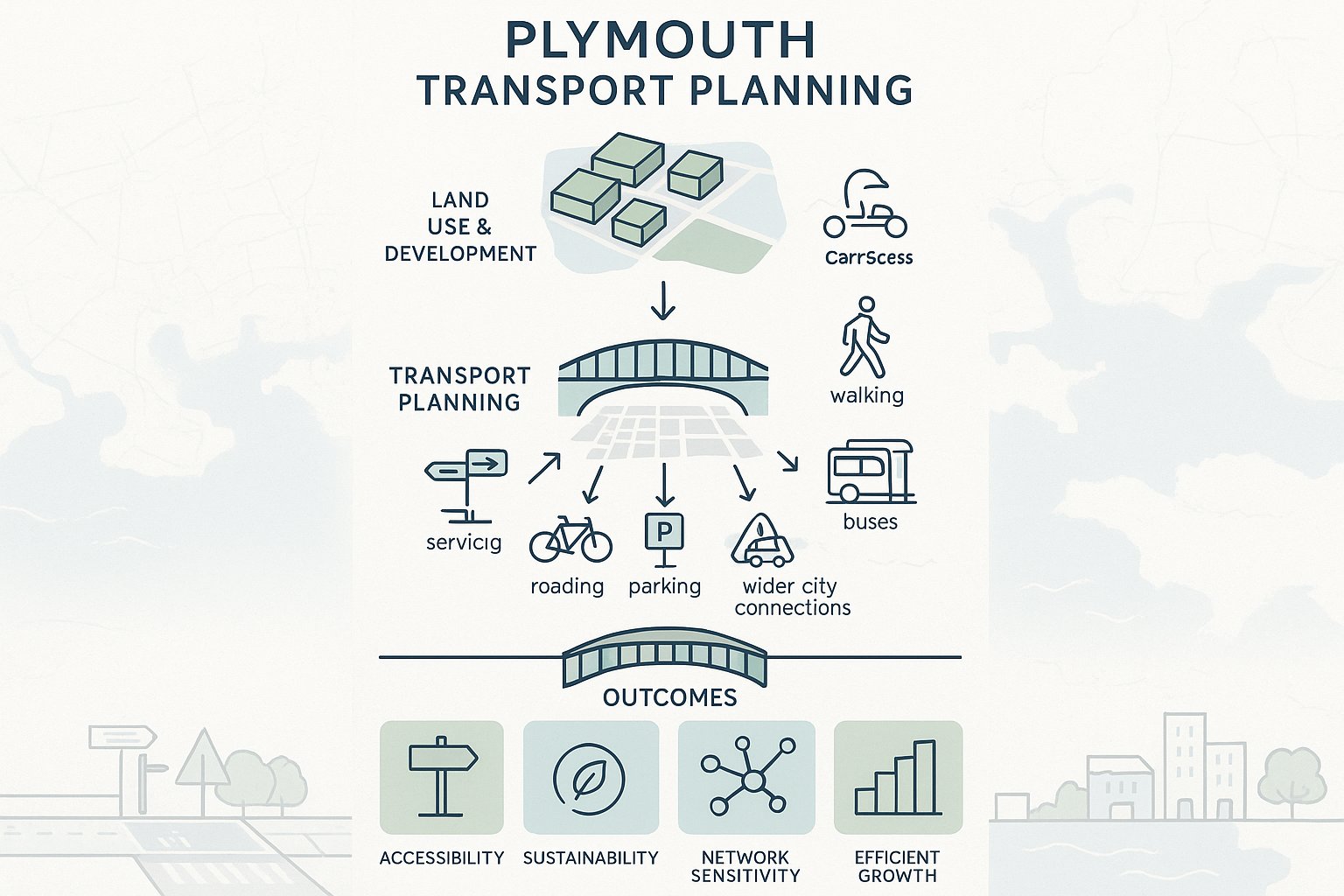
At its core, transport planning in Plymouth is about how development, movement, and network performance fit together. It covers access by car, yes, but also walking, cycling, buses, servicing, road safety, parking demand, trip generation, and how a site connects to the wider city. In practice, it is the bridge between land use planning and day-to-day movement.
That matters because Plymouth’s growth strategy is not simply about building more homes, employment space, or community facilities. It is about directing growth into locations where people can move around safely and efficiently without creating unacceptable pressure on already sensitive parts of the network. The planning system is hence looking for more than a red line boundary and a visibility splay. It wants evidence that a scheme supports accessibility, sustainability, and placemaking.
For applicants, that means transport work often feeds directly into site layout, quantum of development, access arrangements, parking levels, and mitigation packages. A transport issue can quickly become a viability issue, or a programme issue, if it is left too late.
We also see transport planning play an important role in helping teams avoid over-engineering. Not every proposal needs a long, data-heavy assessment. But almost every meaningful proposal benefits from early advice on what the local authority is likely to expect and where the real risks sit.
The Plymouth Planning And Transport Policy Context
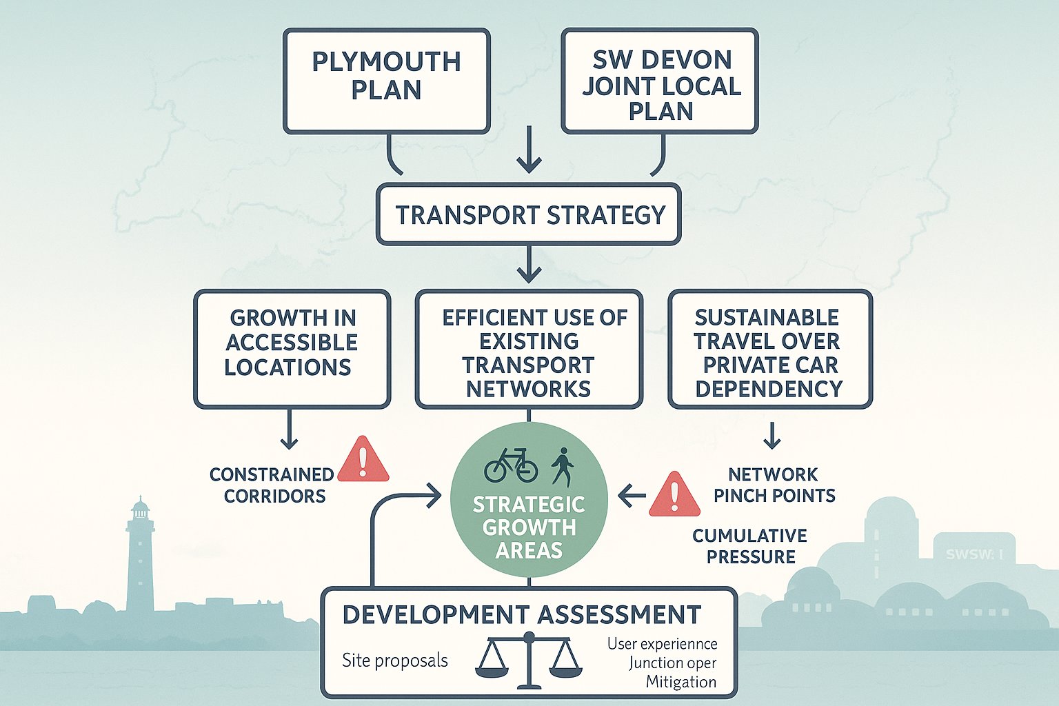
Plymouth’s planning and transport framework is shaped primarily by the Plymouth Plan and the Plymouth and South West Devon Joint Local Plan, adopted in March 2019. Those documents do more than set broad aspirations. They provide the policy logic behind why certain schemes are supported, challenged, or required to provide mitigation.
For transport professionals, the key point is that the city’s strategy links development patterns very closely to sustainable movement. The council’s position has long favoured growth in accessible locations, better use of existing transport networks, and interventions that improve connectivity and reduce pressure on constrained corridors before defaulting to major highway expansion.
That policy context affects how applications are assessed. A site may appear acceptable in purely geometric terms, but still face resistance if it relies too heavily on private car travel, performs poorly against sustainable travel objectives, or adds stress to known network pinch points without a convincing response.
It is also worth remembering that policy interpretation is rarely abstract. Officers usually read transport evidence through the lens of local growth priorities, the surrounding street environment, and cumulative development pressure. So transport reporting in Plymouth needs to be technically sound and locally literate.
Local Plan, Strategic Growth Areas, And Decision-Making Priorities
Policy SPT9 is especially relevant because it ties strategic transport choices to land use distribution and network efficiency. In broad terms, it promotes a balanced approach: concentrate growth in the city’s principal growth areas, maximise the value of existing infrastructure, and support realistic alternatives to private car dependency.
That has practical implications. Development in or near accessible urban locations may be viewed more positively where walking, cycling, and public transport connections are strong. By contrast, proposals in weaker locations often need more work to demonstrate that the transport effects are acceptable.
Decision-making priorities in Plymouth also tend to focus on whether a scheme contributes to a coherent place rather than just avoiding severe impact in a narrow highway sense. We hence look beyond junction operation alone and consider connectivity, severance, user experience, and whether the transport strategy helps the site function as part of the city.
When A Transport Assessment Or Transport Statement Is Likely To Be Required
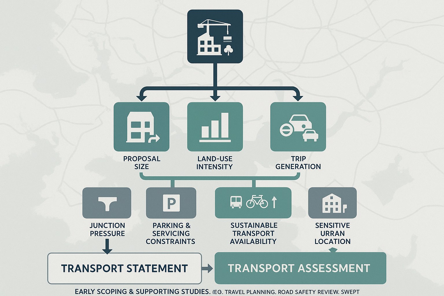
A Transport Assessment (TA) or Transport Statement (TS) is usually required when a development could materially affect travel demand, access arrangements, parking pressure, servicing activity, or the operation of the surrounding network. The exact threshold is not fixed in one simple rule for every site, so the right starting point is always the scale, location, and likely impact of the proposal.
In Plymouth, a TS is often suitable for smaller schemes where effects are limited and can be explained proportionately. A TA is more likely for major development, mixed-use schemes, education, healthcare, student accommodation, large residential projects, or proposals in sensitive locations where existing conditions are already under strain.
Common triggers include:
- a new or altered vehicular access
- material increases in trip generation
- impacts on junctions or strategic corridors
- constrained parking or servicing conditions
- sites with weak sustainable transport links
- development within busy urban areas or growth locations
The local authority’s transport team will generally expect evidence to be proportionate but credible. If a scheme is likely to generate concern, under-scoping rarely saves time. It usually just results in further queries, delayed validation, or requests for additional modelling later in the process.
That is why we recommend early scoping. A short conversation at the outset can clarify whether the council is likely to expect a TS, a full TA, a Travel Plan, road safety input, swept path analysis, or other supporting material.
How Trip Generation, Distribution, And Junction Impact Are Typically Assessed
This is usually the analytical core of transport evidence. We begin by estimating how many trips a development is likely to generate, then consider where those trips will go, which modes they will use, and whether nearby junctions or links can accommodate them acceptably.
Trip generation is often informed by recognised databases, census data, local surveys, comparable sites, and professional judgement. But the local context matters a lot. A city-centre site in Plymouth with good bus access and walkable surroundings should not be assessed in the same way as a more peripheral site with limited alternatives to the car.
Trip distribution then maps likely routing patterns across the network. That step needs to be realistic, because weak assumptions can undermine everything that follows. We normally look at the strategic road hierarchy, local one-way systems, existing turning patterns, major destinations, and constraints that make some routes more attractive than others.
Junction impact is then tested using proportionate tools. Depending on the case, that might include priority junction modelling, signal modelling, roundabout assessment, or a more qualitative review for smaller schemes. Queueing, delay, reserve capacity, and interaction with nearby junctions may all be relevant.
The aim is not just to prove a point on paper. It is to show that the proposal has been properly understood and that any residual impact can either be accepted or mitigated in a practical way.
Key Local Considerations That Can Influence Transport Evidence In Plymouth
Plymouth has a transport character of its own, and that shapes what good evidence looks like. The city’s hills, waterfront geography, historic urban form, bridge and corridor dependencies, and locally constrained junctions all affect accessibility and capacity. A report that ignores those realities will feel generic very quickly.
One recurring issue is that site performance can vary sharply depending on where it sits relative to the city’s strategic routes and main destinations. A development may be physically close to services but still offer poor walking permeability because of severance, level changes, or busy roads. Equally, a location that appears highway-convenient may be policy-sensitive if it reinforces car-led travel patterns.
Cumulative impact also matters. Even modest development can draw scrutiny where there is known pressure from nearby allocations, committed schemes, or established congestion points. In those situations, applicants need to show not only what their own traffic does, but how it interacts with a wider moving picture.
For that reason, local transport planning in Plymouth often benefits from a joined-up evidence base: site access, sustainable travel, parking, servicing, road safety, and network operation should all speak to each other rather than sitting in separate silos.
City Centre Constraints, Waterfront Areas, And Strategic Corridors
The city centre and waterfront locations often need particularly careful handling. These areas may offer excellent sustainable access, which is a planning advantage, but they can also present tight street geometry, competing user demands, loading constraints, and limited room for conventional highway solutions.
Strategic corridors are another focal point. Where development loads onto busy routes or sensitive junctions, officers will typically want comfort that the scheme does not worsen reliability, safety, or severance without suitable mitigation.
In practical terms, that means evidence should reflect the actual place. We may need to test delivery arrangements more carefully in a waterfront setting, examine pedestrian desire lines in central areas, or take a harder look at route assignment where one corridor already carries significant stress.
Walking, Cycling, Public Transport, And Sustainable Travel Expectations
Plymouth’s policy direction is clear: development should support genuine alternatives to private car use wherever possible. So a transport submission that focuses narrowly on vehicle access is rarely enough, especially for urban sites, major schemes, or locations near public transport corridors.
A robust assessment will usually examine walking catchments, crossing opportunities, footway continuity, gradients, cycling links, local bus services, service frequency, and access to day-to-day destinations such as schools, shops, employment, and healthcare. The quality of these connections matters as much as their existence. A bus stop within range is helpful: a bus stop reached via an indirect or uncomfortable route is less persuasive.
For cycling, secure and usable parking is important, but it is only part of the picture. Decision-makers will also be interested in whether people can realistically ride to and from the site, how they join the local network, and whether the development removes or worsens barriers.
For larger schemes, sustainable travel measures often need to be designed in from the start: direct pedestrian routes, filtered permeability, cycle storage, travel information, bus stop improvements, and incentives through a Travel Plan.
This is where many applications either gain momentum or lose it. If the sustainable transport story feels real and site-specific, the overall case becomes stronger. If it feels tokenistic, officers tend to notice.
Parking, Servicing, Access Design, And Highway Safety Issues
Parking and access are often where technical detail becomes highly visible to planning officers, highways teams, and local residents. Even where strategic transport principles are sound, poor practical design can cause trouble.
Parking provision in Plymouth usually needs to strike a balance. Too little parking can create overspill and neighbour concern: too much can undermine sustainable travel objectives and consume valuable site area. The right answer depends on location, land use, public transport availability, likely user profile, and local constraints. We normally set parking numbers in a policy-led context and then test whether the operational reality supports them.
Servicing is another frequent pressure point. Refuse collection, deliveries, emergency access, and turning requirements should be resolved early, especially on constrained urban or mixed-use sites. Swept path analysis can be critical here, but it should reflect realistic vehicle types and practical manoeuvres rather than idealised diagrams.
Highway safety runs through the whole exercise. Visibility, access geometry, pedestrian interaction, internal layout, speed environment, and collision history may all be relevant. If there is a known safety issue nearby, ignoring it is not an option.
In short, the safest route through planning is usually to show that the proposal works in day-to-day use, not just that it can be made to work in theory.
Travel Plans, Mitigation Measures, And Planning Conditions
Where development generates meaningful travel demand, a Travel Plan is often the mechanism that turns sustainable transport ambition into something measurable. It sets out how travel behaviour will be influenced over time, who will be responsible, what measures will be implemented, and how outcomes will be monitored.
A decent Travel Plan is not a generic appendix pasted in at the end. In Plymouth, it should reflect the site’s actual opportunities and limits. For a residential scheme, that might mean welcome packs, cycle vouchers, real-time travel information, and links to local walking and bus services. For employment uses, it may include coordinator roles, car-sharing measures, cycle facilities, shower provision, or staff travel surveys.
Mitigation measures can be physical, behavioural, or both. Examples include junction improvements, crossing upgrades, footway links, bus stop enhancements, traffic management, wayfinding, or contributions secured through planning obligations.
Planning conditions often require details to be submitted later, but the broad strategy should be visible at application stage. If an applicant waits until after consent to think about mitigation, confidence drops.
The best mitigation packages are proportionate and targeted. They respond directly to identified impacts, fit the character of the site, and avoid the sense of a shopping list assembled to satisfy everyone and no one.
Common Challenges In Plymouth Planning Applications And How To Address Them Early
Some issues come up again and again in Plymouth applications. The first is underestimating local network constraints. A proposal may look modest in isolation, but if it feeds into an already sensitive junction or corridor, scrutiny can rise quickly.
The second is weak sustainable access evidence. Applicants sometimes point to nearby facilities without properly testing walkability, gradient, severance, or public transport quality. In a city like Plymouth, those details matter. A route that works on a plan may feel very different on the ground.
Third, there is often a disconnect between transport reporting and site design. Parking, servicing, refuse collection, cycle storage, frontage activity, and pedestrian routes are prepared separately and only reconciled late in the day. That is when awkward compromises appear.
We usually advise teams to address these challenges early by:
- agreeing scope with the local authority where possible
- visiting the site and surrounding streets in person
- testing realistic access and servicing arrangements at concept stage
- reviewing local collision data and known pinch points
- aligning transport work with architecture and planning strategy
For many schemes, the real value is not just in producing a report. It is in using transport input early enough to shape a better application. That tends to save time, money, and a fair bit of frustration later.
Choosing The Right Scope, Surveys, And Supporting Technical Reports
Scoping is where good transport work starts. The aim is to identify what evidence is necessary, proportionate, and locally relevant before design teams disappear too far down the road. That sounds obvious, but it is one of the most common points of failure.
The right scope will depend on development type, scale, local sensitivity, and whether there are known issues around access, capacity, road safety, or sustainable travel. One scheme may only need a concise Transport Statement with a basic access review. Another may require a full Transport Assessment, junction modelling, a Travel Plan, swept path analysis, speed surveys, parking accumulation work, or a road safety audit response.
Surveys should be chosen carefully and timed sensibly. Depending on the case, we may need traffic counts, queue observations, site access surveys, parking beat surveys, non-motorised user audits, bus service reviews, or collision analysis. Out-of-date or poorly timed data can create avoidable arguments.
Supporting technical reports should also tell one coherent story. If the transport note says one thing, the Design and Access Statement says another, and the refuse strategy says something else, confidence falls apart.
For project teams working to tight programmes, experienced input really matters here. On projects we support through ML Traffic, the emphasis is usually on concise, accurate reporting tailored to local authority expectations, so clients are not paying for unnecessary analysis but are still properly covered.
Conclusion
Transport planning in Plymouth is eventually about fit: fit with local policy, fit with the surrounding network, and fit with how people will actually move to and from a site. The city’s planning framework expects growth to be accessible, sustainable, and realistic about existing constraints, so transport evidence needs to do more than tick a validation box.
For applicants and advisers, the practical lesson is straightforward. Start early, scope properly, and build the transport strategy into the design rather than bolting it on later. When trip generation, sustainable access, parking, servicing, safety, and mitigation are considered together, applications tend to be stronger and the planning process tends to be smoother.
And in Plymouth, that joined-up approach is not a luxury. It is usually the difference between a report that merely exists and one that genuinely helps secure consent.
Transport Planning in Plymouth: Frequently Asked Questions
What is transport planning in Plymouth and why is it important?
Transport planning in Plymouth coordinates development, movement, and network capacity to support growth without undermining accessibility, safety, or sustainability. It aligns with the city’s growth strategy to promote accessible locations, stronger walking and cycling links, and effective use of existing networks.
When is a Transport Assessment or a Transport Statement required in Plymouth?
A Transport Assessment or Statement is usually required for developments that materially affect travel demand, access, parking, servicing, or network operation. Major schemes, developments in growth areas, or sites with network constraints generally need detailed assessments to demonstrate acceptable transport impacts.
How does Plymouth’s local planning policy influence transport planning decisions?
Plymouth’s planning policies, including the Plymouth Plan and Joint Local Plan, emphasize growth in accessible locations with sustainable travel options. Policy SPT9 guides decision-making by promoting efficient use of existing networks and prioritizing alternatives to car dependency before major highway expansion.
What are some key local considerations unique to transport planning in Plymouth?
Plymouth’s steep topography, historic street layout, waterfront areas, and constrained junctions create unique transport challenges. Developments must consider local route priorities, cumulative impacts, and the need to support walking, cycling, and public transport to fit the city’s transport character and policy objectives.
How are trip generation and junction impacts assessed for planning applications in Plymouth?
Trip generation estimates how many trips a development will generate based on local data and comparable sites, while trip distribution maps likely travel routes. Junction impacts are then tested using modelling and qualitative reviews to ensure the network can accommodate additional demand safely and efficiently.
What role do Travel Plans and mitigation measures play in Plymouth’s transport planning?
Travel Plans outline how travel behaviour will be influenced through initiatives like cycle parking, car-sharing, and travel information, ensuring sustainable transport use. Mitigation measures may include junction improvements or bus stop enhancements, forming a targeted strategy to address identified transport impacts and support sustainable development.