A warehouse transport assessment has become one of the defining technical documents in modern logistics planning. And in 2026, planning authorities are looking at these reports more closely than ever. That is not just because warehouses are getting bigger. It is because warehouse schemes now sit at the centre of some very sensitive local debates: HGV routing through villages, shift change traffic near schools, late-night van movements, pinch-point junctions already under strain, and pressure to prove that growth will not create a severe cumulative impact on the network.
For architects, planners, developers, lawyers, surveyors and local authorities, the challenge is usually not whether a transport assessment is needed. It is whether the assessment is properly scoped, evidence-led and tailored to the operational reality of the site. A generic report rarely gets far.
In our experience, warehouse proposals succeed when the transport case is built early, around real survey data, realistic trip assumptions and a clear mitigation strategy. That is particularly true for B8 units, logistics parks, last-mile hubs and intensifications of existing warehousing.
In this text, we set out what a warehouse transport assessment actually covers, when it is required, what planning and highway officers tend to focus on, and how to produce a submission that supports a planning application rather than slowing it down.
What A Warehouse Transport Assessment Is And When It Is Required
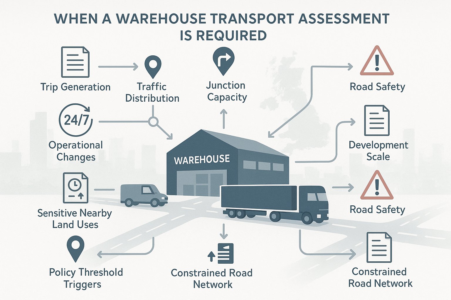
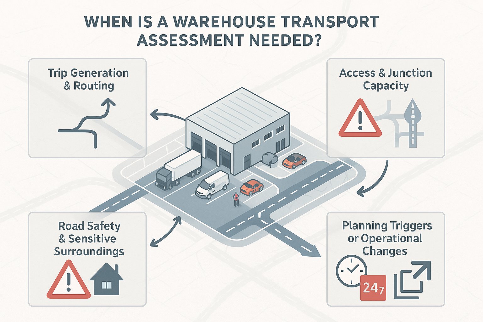
A warehouse transport assessment is a technical report that identifies, quantifies and evaluates how a proposed warehouse development will affect the surrounding transport network. In practice, it looks at the extra trips a scheme will generate, where those trips will go, how the site will be accessed, whether nearby junctions can cope, and whether there are any road safety concerns that need to be addressed.
In UK planning terms, the report is usually prepared to support a planning application where a warehouse is likely to create material transport effects. That often means medium to large B8 development, logistics parks, urban fulfilment centres, or a major expansion of an existing operation. But size alone is not the whole story. A smaller site can still require a full assessment if it sits on a constrained road network, close to sensitive land uses, or in an area with existing safety issues.
Authorities typically ask for this work where HGV, LGV and staff traffic are expected to increase noticeably, or where local policy thresholds are exceeded. We also see it triggered by changes in operation, such as a move to 24/7 working, increased dispatch intensity, or altered servicing patterns.
The key point is simple: if the transport consequences are likely to influence the planning balance, the assessment needs to be robust, site-specific and proportionate. That is what decision-makers expect.
How Warehouse Development Affects The Local Transport Network
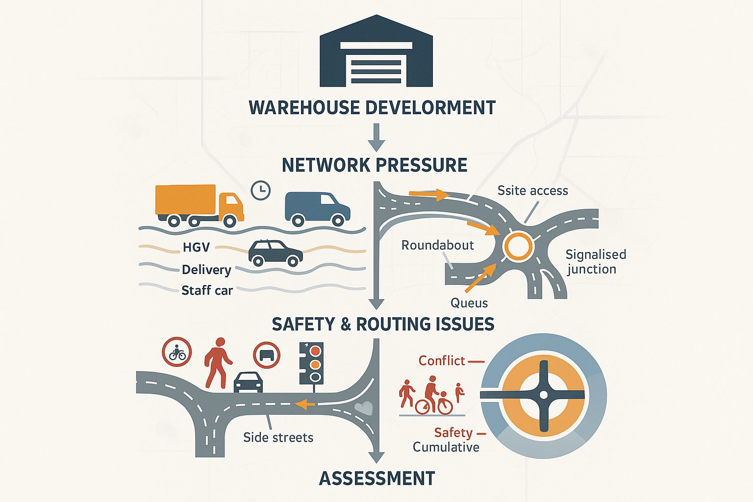
Warehouse development affects the transport network in ways that are both obvious and easy to underestimate.
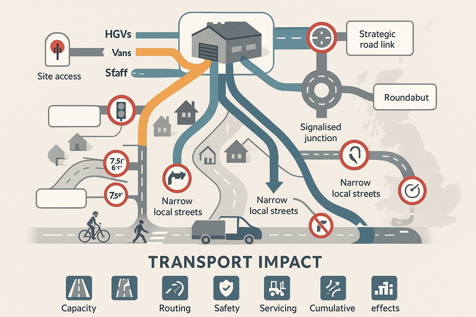
The obvious part is traffic growth. A new or intensified warehouse usually introduces additional HGVs, vans and staff cars. Depending on the operation, that increase may happen across standard highway peak hours, at shift-change periods, or overnight. National distribution centres, cross-dock facilities and parcel hubs can have traffic signatures that look very different from traditional storage-led warehousing.
The less obvious part is where those effects land. A warehouse may place pressure on a site access, a nearby roundabout, a signalised junction on the route to the strategic road network, or on local roads not designed for regular HGV use. Queue lengths can increase. Delay can worsen. Turning movements can become more difficult. And where routing is poorly controlled, freight traffic may spread onto residential streets or roads with weight, width or environmental constraints.
There are also safety implications. New accesses, increased right-turning movements, pedestrian conflict points, and interaction between HGVs, cyclists and general traffic all matter. Even where the total trip increase is manageable, poor access design can become a major issue in consultation.
This is why a warehouse transport assessment must go beyond trip totals. It needs to explain operational impacts in the round: capacity, routing, safety, servicing and cumulative effects.
Typical Planning Triggers For A Warehouse Transport Assessment
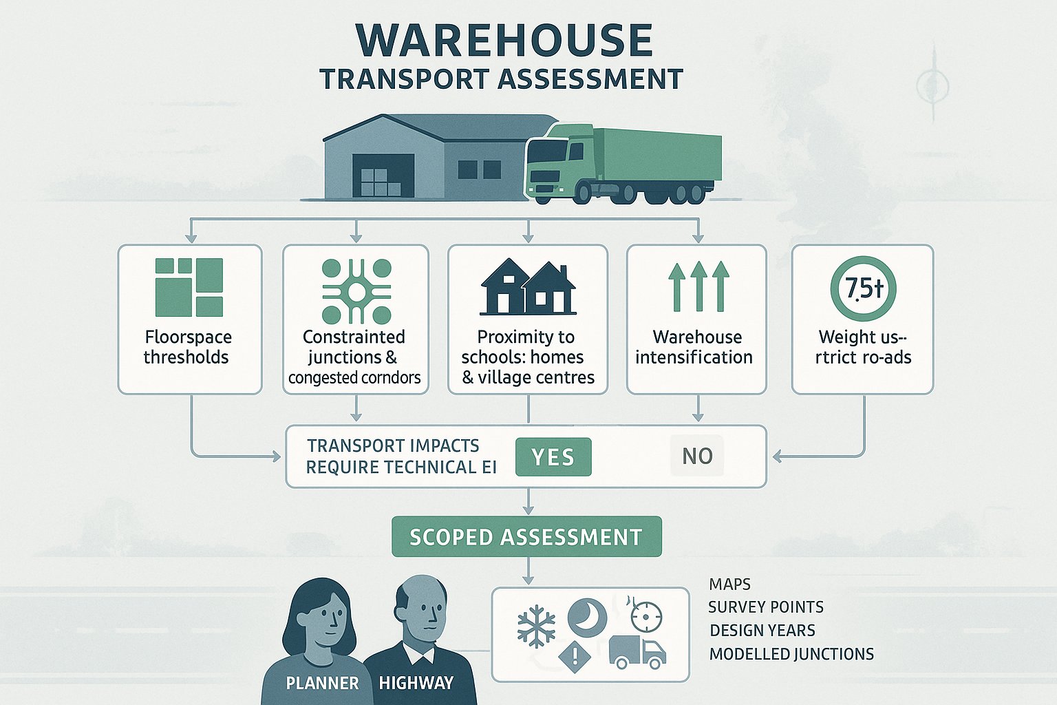
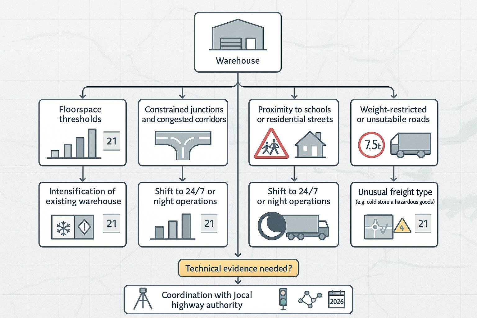
Some triggers are policy-based and some are judgement-based.
Common triggers include:
- Floorspace thresholds for B8 or logistics development set by local validation requirements or transport guidance
- Sites near constrained junctions, already congested corridors or sensitive urban networks
- Proposals close to schools, residential streets, village centres or vulnerable road user routes
- Development with likely impacts on weight-restricted roads or unsuitable local highway links
- Intensification of an existing warehouse, especially if trip activity rises materially
- A move to 24/7 operation, night servicing or pronounced early-morning dispatch peaks
- Schemes with unusual freight characteristics, such as cold-store, hazardous goods or high-turnover last-mile distribution
In practice, planning and highway officers are asking a straightforward question: is this proposal likely to create transport impacts that need technical evidence? If the answer is yes, a scoped assessment is usually the safest route.
We find early discussion with the local highway authority is often the difference between a smooth process and a prolonged one. Agreeing scope, survey locations, design years and modelling junctions up front can prevent the familiar later complaint that the evidence base is incomplete.
Key Elements Included In A Warehouse Transport Assessment
A good warehouse transport assessment is not just a traffic note with a few diagrams attached. It is a structured technical document, usually combining planning context, baseline evidence, forecast impacts and mitigation.
Most robust assessments include:
- A review of relevant national and local policy, including freight, transport and development plan context
- A description of the site, surrounding highway network and accessibility
- Existing traffic conditions, often supported by classified counts, turning counts, queue observations and speed data
- A review of personal injury collision history, typically over a five-year study period
- Forecast trip generation, distribution and assignment for all relevant modes
- Assessment of site access design, internal layout, servicing and circulation
- Junction capacity modelling for the agreed baseline and future years
- Consideration of walking, cycling and public transport, especially for staff travel
- A package of mitigation measures and, where appropriate, a Travel Plan or Framework Travel Plan
The report needs to show not only what the impact is, but also how that impact has been tested. Officers want to see clear methodology, transparent assumptions and a direct line from evidence to conclusion.
That is where experience matters. Firms such as ML Traffic tend to add value by aligning reports with local authority expectations from the outset, rather than retrofitting technical work after objections appear.
Trip Generation, Routing, And Vehicle Profile Analysis
Trip generation is often the most contested part of a warehouse transport assessment, because weak assumptions here ripple through the whole analysis.
For warehouse schemes, we usually need more than a single trip rate. Authorities expect a breakdown by vehicle type and time period. That means separating articulated HGVs, rigid HGVs, vans, staff cars and sometimes visitor or service trips. Daily totals matter, but hourly profiles matter more, especially at AM peak, PM peak, shift change and any operational shoulder periods.
The data source must also be credible. Comparable warehouse sites, TRICS evidence, operator information and existing site surveys can all play a role. But the assumptions need to reflect the proposed operation, not a generic B8 average. A high-bay regional distribution centre behaves differently from a same-day urban hub.
Routing analysis is equally important. Authorities want to know how HGVs will reach the strategic road network, whether sensitive roads can be avoided, and whether any routeing strategy is realistic and enforceable. In many cases, we also need swept-path analysis to confirm that the design vehicles can safely negotiate accesses, junctions and internal turning areas.
Done well, this section reassures officers that the traffic profile is grounded in real operations rather than optimistic guesswork.
Junction Capacity, Access Design, And Highway Safety Review
Once trips are agreed, the next question is whether the network can absorb them.
Junction capacity work normally assesses baseline conditions, future-year background growth, and future scenarios with and without the development. Depending on the network, that may involve priority junction, roundabout or signal modelling using recognised industry tools. The outputs are not just technical tables for an appendix: they form a central part of the planning case. If queues materially worsen, the authority will want to know where, when and by how much.
Access design then comes under close scrutiny. A warehouse site needs more than a compliant bellmouth on paper. Officers typically review visibility splays, carriageway widths, turning radii, entry and exit arrangements, stacking space, gate set-back, and the interaction between HGVs, vans, cars and pedestrians. Internal circulation can become just as important as the site access, particularly where poor layout would cause overspill or reversing conflict.
Safety review ties the whole picture together. That usually includes analysis of recorded collision data, identification of existing risk patterns and, where highway works are proposed, a road safety audit. If there is a recurring local concern such as right-turn conflict, poor crossing provision or excessive speeds, the assessment should confront it directly.
Authorities may accept impact. They rarely accept unresolved safety risk.
How Warehouse Type, Scale, And Operation Change The Assessment
Not all warehouses should be assessed in the same way, and planning authorities know that.
A large national distribution centre with high-bay storage and trunking activity will generate a different transport pattern from a local trade counter warehouse or a last-mile parcel depot. The first may produce fewer but larger long-distance HGV movements tied to strategic routes. The second may generate a high volume of vans, faster vehicle turnover and heavier pressure during narrow dispatch windows.
Scale also changes the assessment. As floorspace, staffing and throughput increase, authorities usually expect a broader study area, more junction modelling and a more detailed servicing strategy. A modest extension on an established industrial estate may justify a proportionate scope. A major logistics park rarely will.
Operational characteristics are often the real differentiator. 24/7 operation can shift the focus toward night-time noise-sensitive periods, early-morning arrivals and worker travel outside normal public transport hours. Seasonal peaks may require scenario testing for pre-Christmas or harvest-related demand. Specialist uses, such as cold storage, hazardous goods or cross-dock operations, can alter dwell times, trailer parking, gate management and queue risk.
This is why warehouse transport assessments work best when they are operationally literate. If the report does not understand how the building will actually function, the numbers usually fall apart under review.
Evidence, Surveys, And Technical Inputs Needed For A Robust Submission
A robust submission depends on current, defensible evidence. That sounds obvious, but weak data is still one of the main reasons transport submissions stall.
The typical evidence base includes:
- Classified traffic counts on surrounding roads
- Turning counts at key junctions
- Automatic traffic counts to establish flow, speed and vehicle composition
- Queue length surveys where congestion is already an issue
- Personal injury collision data, commonly over the previous five years
- Committed development information and agreed background growth assumptions
- Design year scenarios, often opening year and a future assessment year
- Swept-path analysis for relevant design vehicles
- Visibility assessments and access measurements
- Staff travel or local demographic data where mode choice is relevant
Just as important as collecting data is collecting the right data at the right time. Survey dates should be representative, not distorted by school holidays, temporary roadworks or abnormal operating conditions unless clearly justified. If the local authority has network concerns at specific junctions, those locations need to be captured early.
We usually recommend agreeing the survey and modelling scope before major drafting begins. That early discipline saves time later. It is far easier to gather one more turning count at the outset than explain, six weeks into consultation, why a disputed junction was not assessed.
In short: good evidence makes the rest of the report believable.
How A Warehouse Transport Assessment Supports A Planning Application
A warehouse transport assessment is not merely a technical appendix. It is a planning tool.
At application stage, it helps decision-makers understand whether the proposed development can operate acceptably in transport terms and whether any residual cumulative impacts are likely to be severe. That language matters, because planning decisions often turn on whether transport effects are significant enough to justify refusal or whether they can be addressed through design, mitigation, conditions or obligations.
A strong assessment supports the application in several ways. It demonstrates that the transport implications have been properly considered. It shows that key junctions and access arrangements have been tested. It identifies where mitigation is required and, crucially, whether that mitigation is proportionate and deliverable. It can also provide the basis for planning conditions, section 106 obligations, routing agreements, off-site highway works or Travel Plan commitments.
For consultants, legal teams and planning agents, the value is strategic as well as technical. A credible transport assessment can reduce uncertainty in committee reports, help answer objections from residents or consultees, and give officers confidence that the proposal has been responsibly developed.
Put bluntly, if a warehouse scheme has obvious transport sensitivities, the assessment often becomes one of the documents that determines whether the application feels controlled and approvable, or risky and incomplete.
Common Issues Raised By Local Authorities And Highway Officers
Highway officers tend to be consistent in what they challenge. The details vary by site, but the themes recur.
One frequent issue is underestimated trip generation, especially where applicant assumptions do not match the likely throughput of the operation. If the authority believes HGV or van traffic has been downplayed, confidence in the whole report drops quickly.
Another common problem is incomplete modelling. That can mean the wrong junctions have been assessed, future-year growth has been omitted, parameters are poorly justified, or only average conditions are shown when peak stress occurs in shorter, sharper windows. For warehouse proposals, missing shift-change analysis is a classic example.
Access and safety concerns are also high on the list. Officers regularly query visibility, turning radii, gate arrangements, conflict with pedestrians and cyclists, and whether vehicles can enter, wait and turn within the site without queuing back onto the highway. On constrained sites, even a technically workable access can feel operationally fragile.
Then there is the evidence gap: limited collision analysis, outdated counts, no swept paths, vague routing assumptions or unsupported mitigation promises.
Most objections are not mysterious. They usually arise where the submission appears too generic, too optimistic, or too thinly evidenced for the scale of the proposal.
Practical Ways To Reduce Transport Impacts And Strengthen The Scheme
The best transport assessments do not just describe impact. They reduce it.
Start with access strategy. Locating the main access on an appropriate road, with direct connection toward the strategic network where possible, can remove a surprising amount of officer concern. If sensitive local roads are an issue, clearly defined HGV routing measures, reinforced through conditions, agreements or operator management protocols, can make a real difference.
On-site design matters just as much. Adequate HGV parking, trailer storage, waiting areas, turning space and gate set-back help prevent overspill onto the public highway. Separate circulation for HGVs, vans, cars and pedestrians improves both efficiency and safety. Booking systems and delivery management plans can flatten peaks and avoid unnecessary queuing.
For staff travel, a warehouse scheme is stronger when it shows some realism. Not every site will achieve high public transport mode share, but practical measures still matter: shift-linked shuttle services, car sharing, secure cycle parking, showers, footway links and a usable Travel Plan with monitoring.
Sometimes small interventions carry weight: local signage, lining changes, crossing upgrades, signal optimisation or modest junction improvements.
Planning authorities are usually more receptive when they can see that the applicant has not simply measured the problem but has actively designed around it.
Common Mistakes That Delay Approval Or Trigger Further Information Requests
Most delays are avoidable, which is the frustrating part.
A very common mistake is relying on missing, outdated or unrepresentative survey data. If counts are old, taken in abnormal conditions or fail to capture the key operational period, the authority may ask for new work and the programme slips immediately.
Another is inconsistency. Trip rates in one chapter do not match the appendices. Vehicle splits change between assessment tables. Routing assumptions are mentioned but not tested. These are the kinds of details that invite further questions because they suggest the methodology has not been tightly managed.
Lack of early scoping is another problem. If the local highway authority has not been consulted on study area, design year, modelling approach or assessment scenarios, there is a real risk the submitted package will miss something material. Rework after validation is always slower.
Design coordination also catches teams out. We still see access drawings submitted without proper swept-path checks, internal layouts that do not reflect the operational narrative, or geometry that does not meet expected standards. That creates an awkward disconnect between architecture, highways and operations.
If we had to reduce it to one lesson, it would be this: warehouse transport assessments fail less often because they are technically impossible, and more often because they are assembled too late.
Conclusion
A warehouse transport assessment is now a core part of the planning case for many logistics and B8 schemes. In 2026, authorities expect more than a broad estimate of traffic impact. They expect a clear, evidence-based account of how the warehouse will operate, how its trips will affect the network, where risks lie, and what mitigation makes the proposal acceptable.
When the work is scoped early, grounded in representative survey data and aligned with the actual operation of the site, it becomes far more than a compliance document. It helps shape access, inform layout, support negotiation with the highway authority and strengthen the planning application overall.
For development teams, that early investment usually pays for itself. It reduces the chance of objections, avoids repeated information requests and gives decision-makers a much firmer basis for approval. In other words, a well-prepared transport assessment does not just explain a warehouse scheme. It helps make the scheme deliverable.
Warehouse Transport Assessment FAQs
What is a warehouse transport assessment and when is it required?
A warehouse transport assessment is a technical report analysing how a proposed warehouse affects the local transport network, focusing on traffic, junction capacity, and safety. It is required for medium to large warehouse developments or when significant traffic impact is anticipated near sensitive areas or constrained roads.
How does warehouse development impact local transport networks?
Warehouse developments increase HGV, van, and staff car trips, potentially affecting junction operation, queue lengths, and routing patterns. This can lead to congestion, delays, and safety risks at site accesses and nearby roads, especially if freight traffic uses unsuitable local streets.
What key elements are typically included in a warehouse transport assessment?
Key elements include reviewing transport policies, describing the site and network, providing baseline traffic and safety data, forecasting trip generation and distribution, assessing access and junction capacity, conducting road safety reviews, and proposing mitigation and travel plans.
How do the type, scale, and operation of a warehouse influence the transport assessment?
Different warehouse types generate distinct traffic profiles; national high-bay centres create more long-distance HGV trips, while last-mile hubs have frequent van movements. Larger scales require broader study areas and detailed modelling, while 24/7 or specialist operations need analysis of night-time impacts and specific servicing needs.
What practical measures can reduce transport impacts from warehouse developments?
Measures include siting access on appropriate roads, enforcing fixed HGV routing to avoid sensitive streets, providing sufficient on-site parking and turning space, implementing delivery management and booking systems, and promoting sustainable staff travel through shuttle services, cycling facilities, and travel plans.
What common mistakes delay the approval of warehouse transport assessments?
Approval delays often arise from outdated or incomplete survey data, inconsistent trip assumptions, failure to consult highway authorities early on scope and junctions, and submitting design drawings without proper swept-path checks or that do not meet standard access requirements.