Planning applications rarely fail on traffic grounds because someone forgot a buzzword. They fail because the evidence is thin, the assumptions don’t stand up, or the local highway authority simply isn’t persuaded that the network can cope. That is where capacity assessment traffic modelling matters.
In practical terms, it gives us a structured way to test whether a proposed development will overload a junction, worsen queuing, or create knock-on operational problems elsewhere on the network. For architects, planners, developers, solicitors, surveyors and council officers, that evidence often sits at the heart of a transport assessment and can heavily influence whether an application moves smoothly or gets pushed into revision, mitigation, or refusal.
In 2026, expectations are sharper than ever. Local authorities want robust survey data, transparent growth assumptions, realistic future-year forecasts and modelling that reflects how roads actually operate, not just how a spreadsheet says they should. And when the right level of analysis is done early, it can save months of redesign and negotiation later.
In this guide, we set out what capacity assessment traffic modelling means in the UK planning process, when it is usually required, the methods commonly used, the data that matters most, and the issues that tend to attract challenge from reviewing authorities.
What Capacity Assessment Traffic Modelling Means In The Planning Process
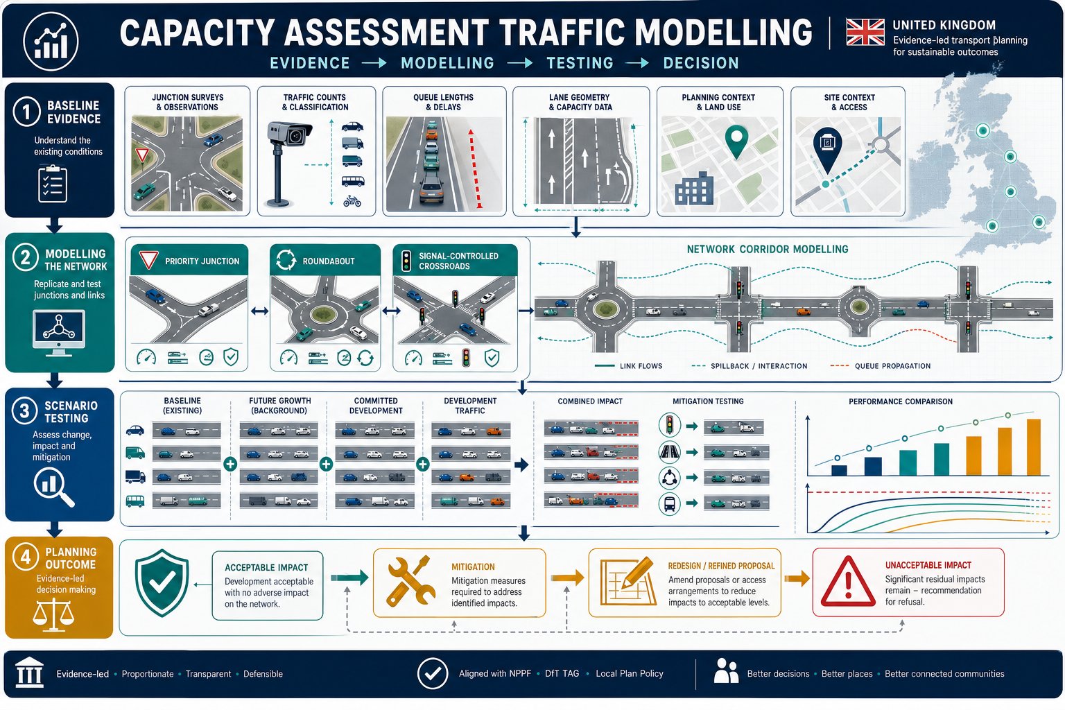
Capacity assessment traffic modelling is the process of testing whether an existing highway asset, typically a junction, road link, access arrangement or local network, can accommodate current and forecast traffic demand safely and efficiently. Within planning, its role is not abstract. It is there to answer a straightforward question: will the development create a severe or unacceptable transport effect?
Usually, we are examining the difference between a baseline scenario and one or more development scenarios. That means comparing existing traffic conditions with future-year flows that include background growth, committed schemes and the proposed site traffic. The outputs help us understand whether the extra demand materially changes operational performance.
For planning teams, this matters because policy and decision-making turn on evidence. A transport statement might be enough for smaller proposals, but once traffic effects become more material, more detailed testing is expected. In many cases, that sits alongside a wider transport assessment for an application needs to demonstrate acceptability.
Good modelling also does something less obvious but equally important: it narrows argument. Instead of vague claims that a junction is “already busy”, we can test likely queue lengths, reserve capacity, delay and operational resilience. That gives applicants, consultants and local authorities a common technical basis for discussing mitigation, phasing or redesign. In our experience, the planning value is not just in producing numbers: it is in producing numbers that are credible, proportionate and specific to the site context.
When A Capacity Assessment Is Needed For A Development Proposal
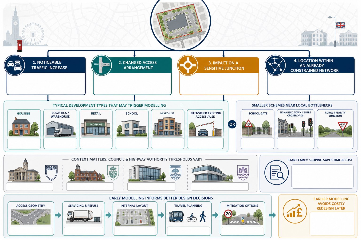
Not every application needs detailed capacity modelling. But where a proposal is likely to generate a noticeable increase in traffic, alter access arrangements, affect a sensitive junction or sit within an already constrained network, the requirement becomes much more likely.
As a rule, local planning authorities and highway authorities ask for capacity assessment where they need clear evidence on operational impact. That often includes residential schemes of meaningful scale, employment and logistics sites, retail development, schools, mixed-use masterplans and changes that intensify vehicle movements at an existing access. A smaller scheme can still trigger modelling if it is located near a known bottleneck, a school gate, a signalised town centre junction or a constrained rural priority junction.
Thresholds vary between authorities, which is why local context matters. Some councils publish guidance on when a transport statement is sufficient and when a full assessment is expected. Others decide case by case. That is one reason early scoping with the authority is useful, particularly where a traffic impact assessment may overlap with broader modelling requirements.
We should also remember timing. Capacity assessment is most valuable before design has hardened too much. If we wait until the application is nearly fixed, the modelling may simply reveal a problem that could have been designed out earlier. Done at the right stage, it helps shape access geometry, servicing, internal layout, travel planning measures and mitigation strategy before those points become expensive to revisit.
How Traffic Modelling Supports Transport Assessments And Planning Decisions
Transport assessments are meant to do more than describe a site and list trip rates. They need to show, with evidence, how movement demand is expected to change and whether the surrounding network can accommodate it. Capacity assessment traffic modelling provides the quantitative backbone for that argument.
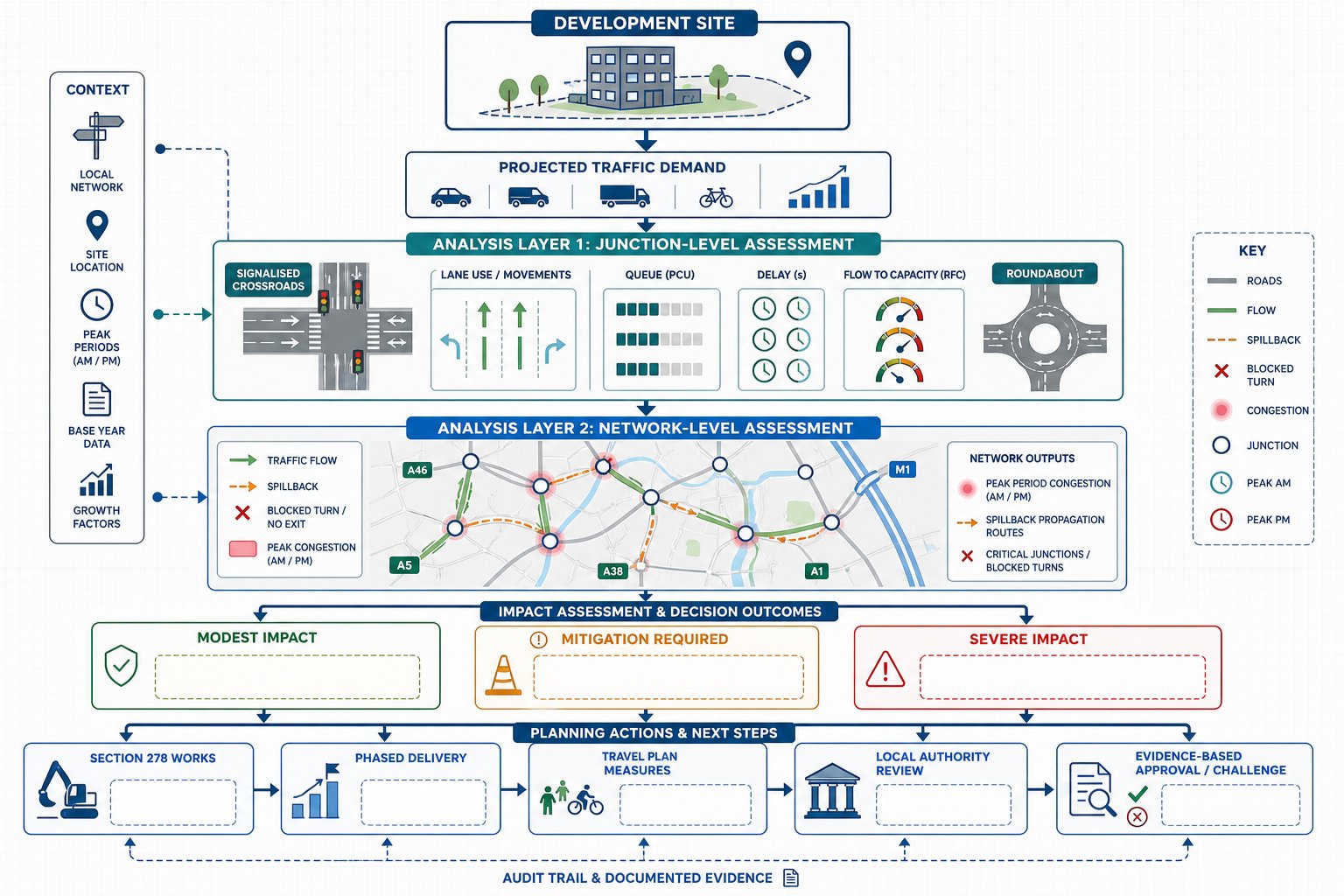
At junction level, modelling tells us whether forecast traffic demand approaches or exceeds practical capacity. At network level, it helps us understand whether localised delay spills into wider operational issues, blocking back across adjacent junctions, obstructing turning movements, or creating unstable peak conditions. Those findings directly inform the planning judgement on impact.
The modelling also helps distinguish between impacts that are theoretically measurable and impacts that are actually material. A development might add traffic, but the crucial question is whether the resulting effect is modest, manageable with mitigation, or severe enough to warrant objection. That is where outputs such as queue length, delay and ratio of flow to capacity become useful.
For applicants, the benefit is strategic as well as technical. Robust modelling can support discussions around mitigation scope, section 278 works, phasing triggers and travel plan commitments. For local authorities, it offers an auditable basis for accepting or challenging an application. And for multi-disciplinary teams, including architects and planning solicitors, it creates a clearer line of evidence than broad narrative alone.
That is why detailed work in this area often sits alongside wider Traffic Impact Assessments and development transport reporting. The stronger the modelling logic, the easier it is to defend the planning position.
The Main Types Of Junction Capacity Assessment Used In The UK

In the UK, the type of capacity assessment used depends on the form of junction being tested and the nature of the question being asked. We do not use one model for everything because roads do not all fail in the same way.
For isolated junctions, the analysis is often relatively focused: can this node process the forecast volume of turning movements within an acceptable level of delay and queuing? For more complex corridors or tightly spaced urban networks, the answer may require more than a single-junction model, especially where interaction between signals, crossings and adjacent accesses affects real-world performance.
The choice of model matters because local authorities will usually expect the method to match the operating characteristics of the highway feature being assessed. A model can be technically sophisticated and still be wrong for the problem if it misses the key mechanism of delay.
Below are the main categories used in practice.
Priority Junctions, Roundabouts, And Signal-Controlled Junctions
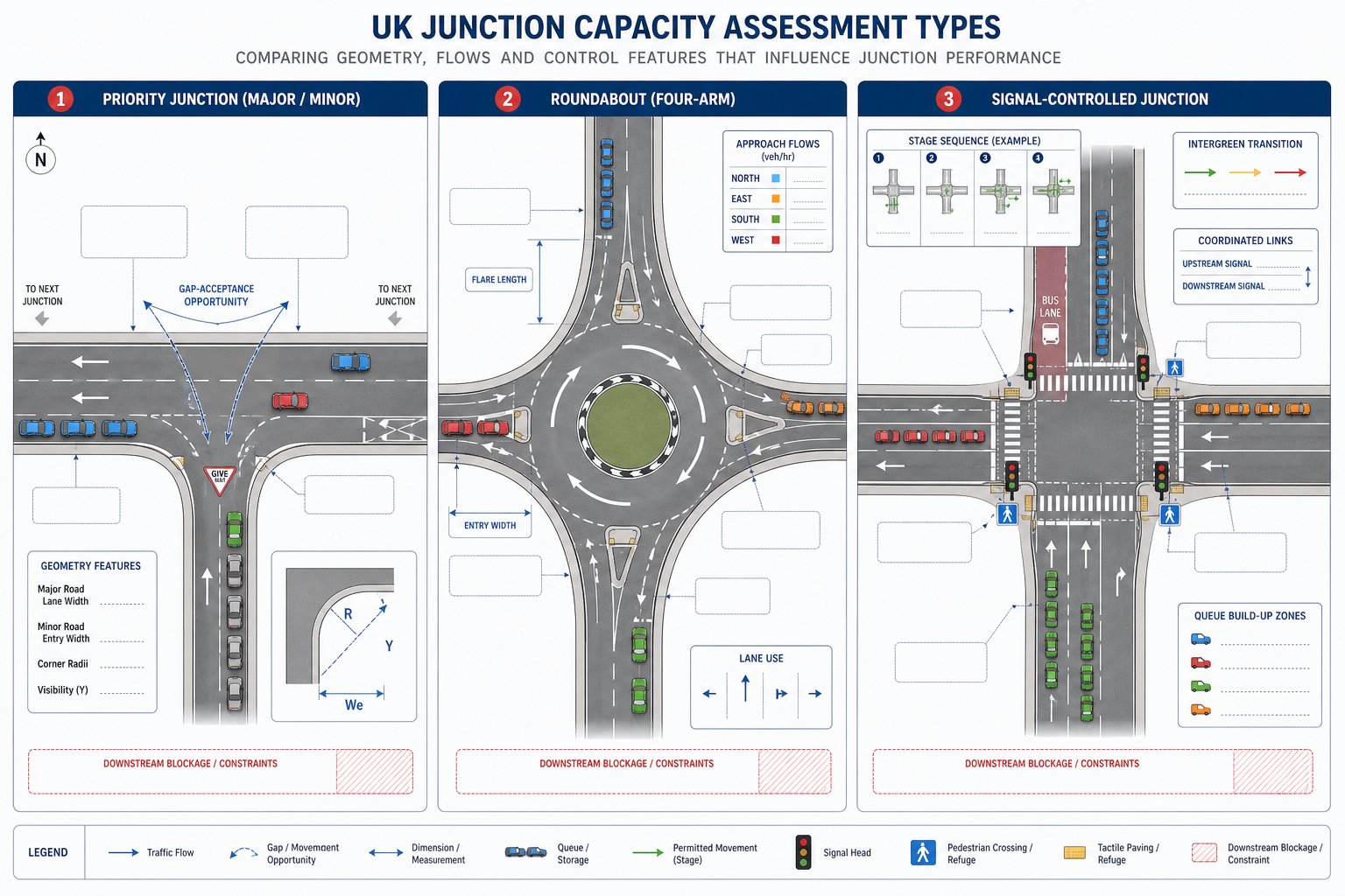
Priority junctions are commonly assessed using industry-standard methods that estimate capacity based on the geometry of the junction, the major road flow and the turning demands from the minor arm. The typical issue here is whether side-road traffic can find enough acceptable gaps to enter or cross the mainline without excessive delay or queue growth.
Roundabouts are different because multiple entry arms interact, circulating flow affects available gaps, and lane use can materially change performance. A compact four-arm roundabout on paper may behave very differently once uneven turning patterns are applied. Small geometry assumptions, flare length, entry width, lane discipline, can shift results more than some teams expect.
Signal-controlled junctions add another layer. Capacity depends on staging, intergreen times, pedestrian phases, lane allocation, saturation flow and coordination with nearby signals. If a crossing is called frequently or a bus priority stage operates, the model needs to reflect it. Otherwise, the forecast can look cleaner than reality.
This is why selecting the right analyst matters as much as selecting the right software. Experienced Traffic Modelling Consultants: tend to spot where a nominally simple junction is actually being influenced by downstream blockage, atypical peak spreading or site-specific driver behaviour that deserves explicit treatment.
Link Capacity, Network Effects, And Wider Highway Performance
Junctions are only part of the story. A development can pass an isolated junction test and still create a highway problem if the links between those nodes are near practical capacity or if queuing on one arm blocks another. That is where link capacity and network analysis come in.
Link capacity assessment looks at whether a stretch of road can carry forecast flows without unacceptable congestion or instability. On strategic or distributor routes, this can be critical, especially where turning pockets are short, lane drops occur, or frontage activity disrupts flow. The link may be the real constraint, not the junction heads themselves.
Wider network effects become especially important in urban centres, around retail parks, near schools, and on corridors with several junctions in close proximity. Static junction models can be useful, but they may understate queue spillback, platooning effects and the way delay propagates through a corridor. In those circumstances, a broader movement strategy, sometimes informed by a Masterplan Traffic Strategy: How growth is distributed across phases, can be just as important as the detailed node testing.
The key point is simple: if the operational issue is network interaction, the assessment method has to capture network interaction. Otherwise, the application can look compliant on paper while leaving obvious concerns unresolved for the reviewing authority.
Core Data Needed To Build A Robust Capacity Assessment
Most disagreements over traffic modelling are not really about mathematics. They are about inputs. If the survey data is weak, the geometry is wrong, committed development has been omitted or growth assumptions are unclear, even elegant modelling will not carry much planning weight.
A robust capacity assessment starts with a defensible evidence base. That usually includes observed turning count surveys, queue surveys where relevant, site access observations, speed data if the access design is sensitive, and a reliable record of junction geometry and lane usage. Then we add development traffic, future-year growth and scenario testing.
What local authorities want is not perfection: they want traceability. They need to see where the data came from, why the assumptions are reasonable, and whether the test reflects likely operating conditions. If those points are handled well, discussions become more constructive. If they are handled poorly, the review often gets stuck in avoidable technical challenge.
Survey Data, Development Trip Generation, And Future Year Forecasts
Survey quality is the foundation. Turning counts should reflect representative conditions, avoid abnormal dates, and cover the peaks that matter for the proposed land use and the surrounding network. In some cases, that means weekday commuter peaks. In others, food retail, leisure, stadia, schools, it may mean a very different survey profile. If the survey day is distorted by roadworks, poor weather, rail strikes or school holidays, the authority may reject the baseline before it even reaches the modelling stage.
Geometry data matters just as much. The number of lanes, flare lengths, storage space, stop line positions and lane markings all affect performance. A surprisingly common problem is relying on outdated mapping rather than a current site check.
Trip generation then converts the proposed development into forecast traffic demand. That should be evidence-led, typically using suitable survey databases, local comparators or agreed benchmarks. Arrival and departure profiles need to match the actual use, not a generic average that flatters the result.
Future-year forecasts combine baseline traffic with growth and development traffic to test operational performance at an assessment year, often opening year and a later design year. For larger schemes, this process may sit within wider Commercial Traffic Engineering work where access, servicing and highway interface all need to align.
Committed Development, Background Growth, And Sensitivity Testing
One of the fastest ways to weaken a planning submission is to underplay future demand. Local authorities will usually expect committed development to be included where it is relevant and likely to influence the study network. That means approved schemes, allocations or developments with a realistic prospect of delivery, depending on the authority’s scoping position.
Background growth is also important, but it needs judgement. Blindly applying a generic factor without considering local network changes can be just as problematic as ignoring growth altogether. Sometimes strategic forecasts are appropriate: sometimes local evidence and known constraints justify a more tailored approach.
Sensitivity testing is where robust assessments separate themselves from optimistic ones. We should ask what happens if trip rates are slightly higher, if traffic growth outpaces central assumptions, if a key mitigation scheme is delayed, or if a different distribution pattern emerges. The purpose is not to invent worst-case fiction. It is to show that the conclusions are resilient.
This becomes especially relevant on housing-led schemes, where a residential traffic impact review may need to consider school-run peaks, multi-phase occupation and cumulative development across a settlement edge. Authorities are often reassured when they can see that uncertainty has been tested openly rather than buried in the appendix.
How Capacity Assessment Traffic Modelling Is Typically Carried Out
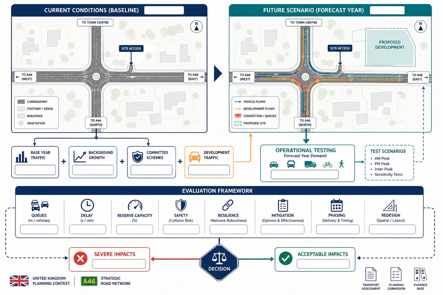
The process usually begins with scoping. We identify the site context, likely trip impacts, the study area, relevant junctions, peak periods and the assessment years. Ideally, that scope is discussed with the local highway authority early, because disagreement about study area or methodology can waste weeks later on.
Next, we establish the baseline using surveyed traffic flows and verified geometry. We then estimate development trips, distribute and assign them across the network, and combine them with background growth and committed development to build future-year scenarios. Common scenarios include a do-minimum case and a do-something case with mitigation.
Those flows are then tested using the appropriate junction or network models. At this stage, the work is rarely just mechanical. We sense-check lane allocations, compare outputs with observed conditions, examine whether queues would physically fit within available storage, and check whether one constrained arm could distort neighbouring junction performance.
If issues emerge, mitigation options are tested. That might include ghost island right-turn lanes, signal optimisation, revised lane marking, access relocation, mini-roundabout conversion, pedestrian crossing amendments, or internal site changes that reduce conflict at the boundary. For larger sites, phasing and trigger points may also be modelled.
At ML Traffic, that sort of exercise usually sits within a wider package of concise reporting and local-authority-focused evidence, often linked to Traffic Flow Management considerations where network operation matters beyond a single junction.
Common Outputs, Performance Indicators, And What They Mean
Capacity modelling produces numbers, but planning teams need interpretation. The most common outputs are ratio of flow to capacity, reserve capacity, delay, queue length and, in some frameworks, level of service or practical operational grade.
Ratio of flow to capacity tells us how close demand is to the theoretical or practical limit of the junction or movement. Values approaching or exceeding capacity suggest a stressed condition, though the interpretation depends on the model type and local context.
Delay indicates how long vehicles are expected to wait. High delay can be material even where theoretical capacity has not yet fully failed, especially if the junction serves sensitive turning movements, school access or emergency routes.
Queue length is often the output that matters most on the ground. A queue that blocks an upstream access, pedestrian crossing, bus stop or adjacent junction can create consequences well beyond the modelled node. That is why average queue alone is not always enough: maximum or percentile queue can matter in review.
Level of service is a broader descriptor of operational quality. Some authorities find it useful, others focus more directly on delay and queue metrics.
What matters in planning is not one absolute threshold applied blindly. It is whether the outputs, taken together, indicate a development impact that is acceptable, severe, or manageable through mitigation and design refinement.
Frequent Issues That Lead To Challenge From Local Authorities
Most local authority challenges are predictable. They tend to arise where the modelling appears selective, opaque or disconnected from observed reality.
A common issue is poor baseline data: old traffic counts, surveys undertaken during abnormal conditions, missing queue observations, or geometry that does not match the actual layout. Another is weak forecasting logic, trip rates without justification, unrealistic modal assumptions, or committed development left out because it complicates the result.
Authorities also push back where modelling isolates one junction even though everyone involved knows the operational issue is corridor-wide. If queues routinely spill back from one node into another, an isolated assessment can look evasive. The same applies where internal site operation, servicing or nearby accesses materially influence the network but have been treated as someone else’s problem.
Presentation matters too. Reviewers are more likely to challenge work when assumptions are buried, diagrams are unclear, or the narrative does not explain why a result should be accepted as reasonable. Strong technical analysis can still stumble if the reporting is hard to audit.
This is one reason a joined-up submission helps. Capacity evidence tends to be stronger when it aligns with the broader transport assessment for developments: narrative, access design, mitigation schedule and planning strategy. In practice, authorities are not looking for perfection: they are looking for evidence they can trust.
Conclusion
Capacity assessment traffic modelling remains one of the most useful tools we have for testing whether development traffic can be accommodated on the UK highway network. Done properly, it gives planning teams clear evidence on operational effects, helps identify realistic mitigation, and reduces avoidable argument during application review.
The strongest submissions are rarely the ones with the flashiest software. They are the ones built on sound surveys, transparent assumptions, proportionate methodology and a clear explanation of what the outputs actually mean. That applies whether we are assessing a single priority junction for a small scheme or testing wider network interaction for a phased masterplan.
For developers, architects, planners and councils alike, the practical lesson is simple: start early, scope properly, and make sure the modelling matches the real transport question being asked. When those basics are right, planning decisions tend to become faster, clearer and more defensible.
Frequently Asked Questions About Capacity Assessment Traffic Modelling
What is capacity assessment traffic modelling in the UK planning process?
Capacity assessment traffic modelling tests whether a junction, road link, or network can accommodate current and future traffic safely and efficiently, helping determine if a proposed development causes unacceptable transport effects.
When is capacity assessment traffic modelling typically required for a development?
It is usually needed when a development will significantly increase traffic, affect sensitive junctions, or is near constrained networks, such as large residential schemes, retail sites, or near school gates.
How does capacity assessment traffic modelling support transport assessments for planning decisions?
The modelling provides quantitative evidence on capacity, delay, and queue lengths, informing planning authorities whether traffic impacts are manageable or require mitigation in transport assessments.
What are the main types of junction capacity assessments used in the UK?
Priority junctions, roundabouts, and signal-controlled junctions are assessed using tailored models that consider geometry, traffic flows, and operational characteristics specific to each junction type.
What core data is essential for a robust capacity assessment traffic model?
Robust models rely on accurate turning count surveys, site geometry verification, realistic trip generation estimates, future-year traffic forecasts including committed development, and sensitivity testing for uncertainties.
Why is addressing network effects important beyond isolated junction modelling?
Because congestion at one junction can spill back and affect others, a wider network analysis captures these interactions to avoid underestimating delays and operational problems across the corridor or area.