A residential traffic impact study can make the difference between a housing application that moves forward cleanly and one that stalls in queries, redesigns and transport objections. By 2026, that gap is getting wider. Local planning authorities are looking more closely at network capacity, road safety, active travel links and the credibility of development assumptions. And because many housing sites now come forward on constrained urban edges, near schools, or within already stressed road networks, transport evidence has to be tighter than it was even a few years ago.
We see this regularly in practice. A scheme may look straightforward on a layout plan, yet once peak-hour trips, junction stress, parking pressure, servicing and walking routes are tested properly, the transport story becomes much more complex. That does not mean every residential proposal needs a lengthy, over-engineered report. It does mean the study has to be proportionate, correctly scoped and rooted in local conditions.
In this guide, we set out what a residential traffic impact study actually covers, when it is likely to be needed, the surveys and modelling usually involved, and where planning teams often come unstuck. The aim is practical: to help architects, planners, developers, lawyers, surveyors and councils understand what good transport evidence looks like before an application is submitted.
What A Residential Traffic Impact Study Is And When It Is Needed
A residential traffic impact study examines how a proposed housing development will affect the surrounding transport network and whether that effect is acceptable in planning terms. In practice, that means forecasting the trips the scheme is likely to generate, identifying where those trips will go, testing the effect on nearby junctions and links, and considering whether mitigation is needed so the development can operate safely and efficiently.
The study usually addresses more than vehicle movements. A properly prepared submission should also look at pedestrian access, cycle routes, public transport availability, parking provision, servicing and road safety. On many sites, those points matter just as much as pure vehicle capacity. A junction might still function, for example, but a poor footway connection to a bus stop or a weak visibility arrangement at the site access can still trigger objections.
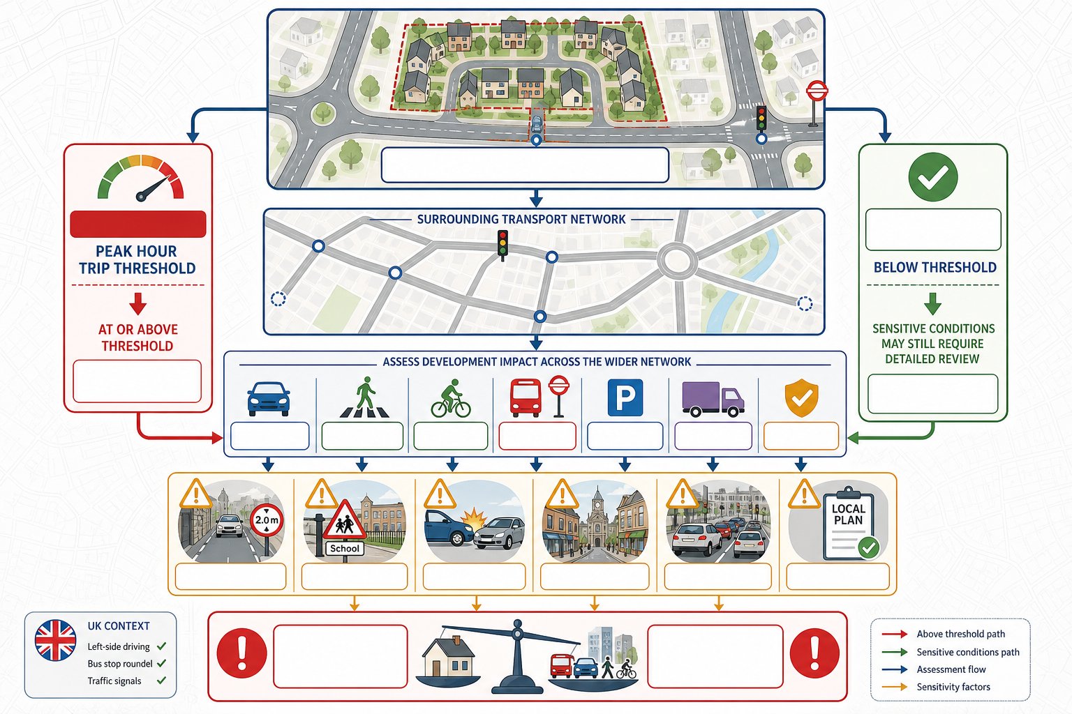
As a broad rule, local authorities often expect a fuller study when a development is likely to generate around 100 or more two-way trips in a peak hour, though local thresholds vary. Smaller schemes may only require a Transport Statement rather than a full Transport Assessment. Even so, the need for a detailed transport submission is not driven by numbers alone. Sensitive locations, known collision history, constrained accesses, school traffic, town-centre pressure or conflict with local plan policy can all push a site into more detailed assessment.
For teams planning applications in 2026, the key point is simple: the trigger is usually impact, not just scale.
How Residential Schemes Generate Vehicle, Walking And Cycling Trips
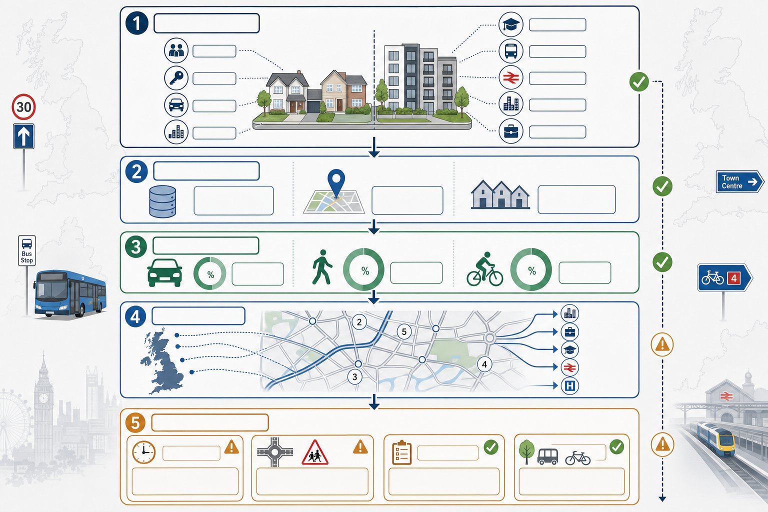
Residential developments generate trips in patterns that are fairly well understood, but never entirely generic. Household size, tenure, car ownership, density, proximity to schools, bus services, rail stations, town centres and employment areas all influence how people travel. A suburban family housing scheme on the edge of a market town will behave differently from an apartment-led site near a railway station. That sounds obvious, yet many weak submissions still lean too heavily on standard rates without enough local interpretation.
In most cases, trip generation starts with accepted database evidence and comparable site data. From there, we adjust assumptions to reflect the actual development mix and local context. Vehicle trips are only one part of the picture. Walking and cycling demand should also be estimated, especially where policy support for active travel is strong or where the authority wants clear evidence that shorter trips can be made by non-car modes.
Once total trips are established, they must be distributed and assigned across the network. This is where census journey-to-work information, observed traffic patterns, local junction counts and knowledge of key destinations become important. The assignment should feel believable to a case officer and highway authority engineer. If it does not, the whole assessment can wobble.
In more complex cases, our approach often sits alongside broader Traffic Impact Assessments work, particularly where a residential site forms part of a mixed-use or phased allocation.
The Main Triggers Used By Local Planning Authorities
Local planning authorities usually focus on a familiar set of triggers when deciding how much transport analysis a housing proposal requires.
The first is expected trip generation, especially in the weekday AM and PM peaks. A scheme that adds around 100 or more peak-hour movements will often draw requests for a more detailed evidence base, though there is no universal national cut-off and county guidance can differ.
The second is location sensitivity. Sites near congested junctions, schools, high streets, air quality management areas or roads with a poor safety record are more likely to need fuller testing even if the development itself is modest.
Third, authorities look at planning context. If a proposal departs from the local plan, comes forward ahead of strategic infrastructure, or raises obvious local concerns such as rat-running or overspill parking, transport scrutiny usually increases.
And finally, officers consider whether a scheme could reasonably support more sustainable travel than the applicant first suggests. If the submission underplays walking, cycling or bus opportunities, expect questions.
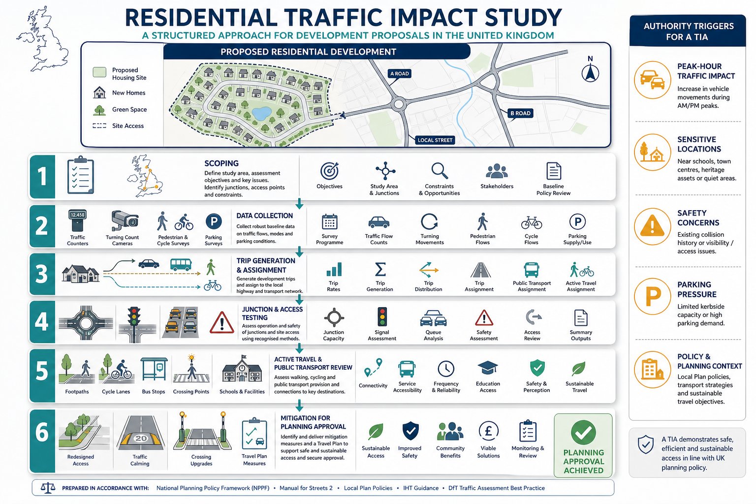
What Scoping Should Cover Before Any Assessment Starts
Good scoping saves time, reduces argument later and helps keep a planning programme realistic. Before any surveys are commissioned or models are built, we should be agreeing the basic rules of the assessment with the planning and highway authority wherever possible.
That scoping exercise normally covers the study area, the junctions and links to be tested, the survey dates, the peak periods to assess, the forecast years, background growth assumptions, committed development to include and the modelling tools to be used. It should also confirm whether the authority expects only highway analysis or a wider multi-modal review covering walking, cycling and public transport in detail.
This stage matters because many transport disputes begin with mismatched expectations rather than technical errors. A consultant may assess five junctions while the authority expected eight. Or an applicant may model standard weekday peaks when the real issue is school drop-off traffic or a Saturday retail peak nearby. Those gaps are avoidable.
Scoping should also test whether the scheme needs a Transport Statement, a Transport Assessment, or a more extensive package with travel planning, road safety review or environmental input. On larger or more sensitive sites, transport evidence may need to align with wider environmental impact assessment work, especially where cumulative effects, air quality or strategic mitigation are in play.
A short scoping note, agreed early, can prevent months of unnecessary back-and-forth.
Site Access, Visibility, Parking And Internal Layout Issues
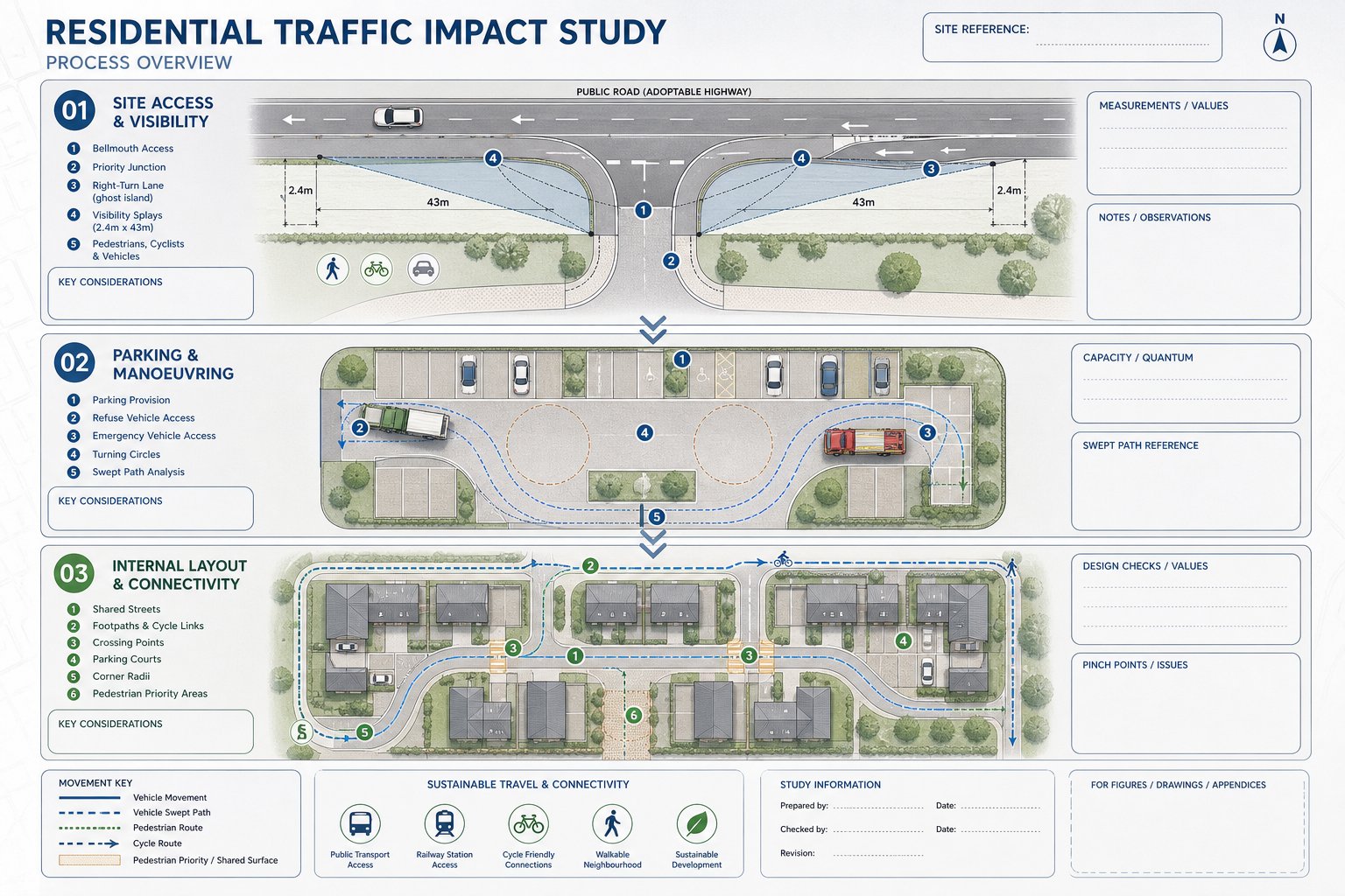
A residential traffic impact study is not only about what happens off site. It also has to show that the development can function safely and logically within its own boundaries and at its points of connection to the public highway.
Site access is usually the first focus. The authority will want to know whether the access form is suitable for the scale of development, whether visibility splays meet the required standards, and whether drivers, pedestrians and cyclists can enter and leave safely. If the scheme relies on a new priority junction, ghost island right-turn lane or simple bellmouth access, that arrangement needs to be justified with reference to observed speeds, geometry and likely usage.
Parking is another regular pressure point. Under-provision can create overspill and neighbour objections: over-provision can undermine sustainable travel policy and reduce development quality. The right answer depends on local standards, public transport accessibility, housing mix and likely car ownership. We also need to review turning space, refuse vehicle access, emergency access and whether larger vehicles can manoeuvre without awkward reversing movements.
Internal layout matters more than some teams expect. Tight corners, poor visibility around parking courts, weak pedestrian priority and disconnected cycle access can all become reasons for redesign. For many schemes, transport input works best when coordinated early with layout design, rather than after the site plan has effectively been fixed.
That is one reason a Residential Development Transport strategy is often most valuable at pre-application stage, not just before submission.
How Traffic Data Is Collected And Which Surveys Are Typically Required
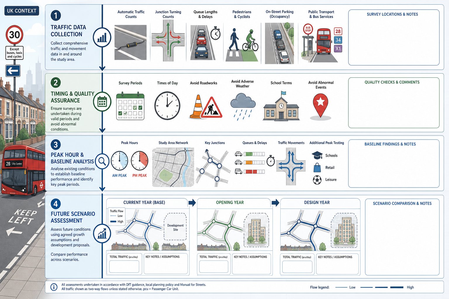
Transport evidence is only as good as the data behind it. If surveys are outdated, unrepresentative or too narrow in scope, the analysis built on them will usually be challenged.
For residential development, common surveys include automatic traffic counts to understand daily flow patterns and speeds, turning movement counts at nearby junctions, queue length and delay surveys where congestion is already a concern, and pedestrian and cycle counts where active travel effects need to be understood. In some locations, parking beat surveys are also essential, particularly where the site sits within an existing stress point for on-street parking.
Public transport information can matter too. That may involve reviewing service frequency, walking distances to stops, timetable reliability and, in some cases, boarding data where bus capacity is likely to become an issue.
Survey timing is critical. Authorities will often question school holiday data, periods affected by roadworks, abnormal weather or local events, and counts that are simply too old. Post-pandemic travel patterns have settled in many places, but local variation remains real, so recent observed conditions still carry more weight than broad assumptions.
For developers, the practical lesson is straightforward: do not leave surveys until the layout is nearly finished. By then, if extra data is needed, the planning programme can slip.
Peak Hours, Baseline Conditions And Future Year Scenarios
Most residential assessments focus on weekday AM and PM peak periods because those are the times when commuter and school-related pressures usually overlap with network constraints. But not always. Near schools, leisure destinations or retail centres, the authority may also ask for school peaks, inter-peak testing or Saturday analysis.
The baseline case should reflect observed conditions on the network as it operates now, not a theoretical average day that nobody recognises. That means accounting for existing turning flows, queues, delays, safety concerns and modal conditions.
From there, the assessment normally moves to future year scenarios. These include background traffic growth, committed developments and the traffic associated with the proposed scheme. Depending on the scale of the site, we may assess a base year, an opening year and a future design year to show both immediate and longer-term effects.
What matters most is transparency. If growth factors, trip rates or assumptions around committed development are not clearly explained, confidence in the outputs falls very quickly.
Junction Capacity Modelling And Network Impact Assessment
Once trips have been forecast and assigned, the next question is whether the surrounding network can absorb them. That is where junction capacity modelling comes in.
Depending on the junction type, recognised tools are used to test priority junctions, roundabouts, signals or wider network interactions. The outputs usually consider ratio of flow to capacity, queue lengths, delays and, in some cases, reserve capacity. But numbers on their own are not enough. We need to interpret whether any change is material in planning terms, whether it creates a severe residual impact, and whether the model reflects what drivers actually experience on the ground.
For smaller housing schemes, the modelling may be quite focused: one site access and a handful of nearby junctions. For larger allocations, the work can become much broader, looking at route choice, cumulative growth and strategic interactions. In those cases, the residential traffic impact study often forms part of a wider traffic impact assessment package.
A common mistake is treating model software as the answer rather than a tool. If saturation appears high but observed operation is stable, we need to explain why. If queueing is forecast to increase, we should show whether the effect is occasional, persistent, or capable of mitigation. High-quality modelling is technical, yes, but it also depends on judgement. That tends to be the difference between a report that reassures an authority and one that simply generates another round of questions.
Sustainable Travel, Public Transport And Active Travel Considerations
Planning policy in 2026 expects residential development to do more than prove roads can cope. Authorities also want evidence that people living on the site will have realistic alternatives to private car use.
That means reviewing walking routes to schools, local shops, open space and bus stops: cycle links to nearby centres and employment areas: the quality of crossing points: and the practicality of public transport connections. Distance alone is not enough. A bus stop 400 metres away may look fine on a plan, but if the route involves a narrow footway, poor lighting or crossing a fast road without a refuge, the real accessibility picture changes.
Cycle parking, permeability and directness matter as well. If cyclists have to navigate awkward shared surfaces, multiple barriers or indirect links, take-up will be lower no matter what the policy statement says.
This part of the study often has an outsized influence on planning outcomes because it links transport evidence to broader design and placemaking goals. A scheme with strong active travel connections can often justify a more balanced view on parking, trip rates and mitigation. A car-dependent site in a weakly connected location faces a higher evidential bar.
In short, a credible residential traffic impact study should not treat sustainable travel as a bolt-on chapter. It needs to show, with specifics, how the site will function for people who are walking, wheeling, cycling and using public transport.
Mitigation Measures That Can Support A Planning Application
Mitigation is where transport work shifts from diagnosis to problem-solving. If the study identifies capacity pressure, safety concerns or weak sustainable access, the next task is to show how those issues can be reduced to an acceptable level.
The right package depends on the nature of the impact. Highway mitigation might include access redesign, localised junction improvements, signal optimisation, lane marking changes, visibility improvements or new pedestrian crossing facilities. In residential areas, traffic calming, parking controls and waiting restrictions are also common tools, especially where the risk is informal parking or rat-running rather than pure junction failure.
Sustainable measures can be just as important: better footway links, dropped kerbs, cycle connections, bus stop upgrades, wayfinding, travel plans and welcome packs for first occupants. On larger schemes, developer contributions may support wider network improvements beyond the red line boundary.
But authorities are rarely persuaded by mitigation that feels generic. A line in the report saying residents will be encouraged to walk more is not mitigation. A direct, lit and overlooked path to the nearest primary school, but, is. Likewise, a travel plan works best when tied to site realities, management arrangements and monitoring.
The most effective mitigation packages are proportionate and specific. They show that we understand not just what the model predicts, but what the place actually needs to function well.
Common Reasons Residential Transport Submissions Are Challenged
Most challenged submissions fail in fairly predictable ways. The frustrating part is that many of those issues are avoidable.
One common problem is poor scoping. If the authority believes relevant junctions, peak periods or committed developments have been left out, confidence in the whole submission drops immediately. Another is weak or dated survey information. Even a technically neat report can be undermined if the counts were undertaken during atypical conditions or no longer reflect current traffic patterns.
Trip generation is another flashpoint. Authorities often push back where rates appear unrealistically low, where the selected comparison sites are not genuinely comparable, or where the applicant assumes an optimistic level of non-car travel without enough evidence. Distribution assumptions can attract similar scrutiny. If the report says 40 per cent of site traffic will turn one way but local knowledge suggests the opposite, expect a challenge.
Modelling errors, omission of pedestrian and cycle impacts, and mitigation that lacks detail are also regular causes of delay. And sometimes the issue is simpler than that: the report may be technically competent but badly explained.
We find that concise, authority-aware reporting usually performs better than overlong submissions packed with unexplained appendices. That is particularly true when a residential traffic impact study is being reviewed alongside planning, highways and legal input under tight timescales.
How A Traffic Impact Study Fits Alongside A Transport Statement Or Transport Assessment
These terms are often used loosely, which can create confusion early in a project.
A Transport Statement is usually a shorter, more proportionate document for smaller schemes with limited transport impacts. It still addresses access, parking, trip generation and safety, but usually with lighter analysis and less modelling. A Transport Assessment is broader and more detailed, typically used where impacts are more substantial or the site context is more sensitive.
The traffic impact study is not really a separate rival document to either of those. Rather, it is a core component within them, scaled according to the likely effect of the development. In a small residential proposal, the traffic impact material may be a concise chapter within a Transport Statement. In a larger site, it may become a substantial part of a full Transport Assessment, with modelling, future year testing and a more developed mitigation package.
For applicants, the practical issue is not the label but the scope. What level of evidence does the authority expect, and does the submission answer the real transport questions raised by the site? If those are clear from the outset, document titles become far less important.
That is also why teams often benefit from aligning early with the authority on whether the application needs a short statement, a full assessment or something in between.
What To Prepare Before Instructing A Residential Traffic Consultant
A consultant can work much faster, and usually more accurately, if the project team assembles the right material early.
At minimum, we should have a clear red line plan, a draft access concept, the proposed number and mix of dwellings, likely phasing, and an expected opening year. It also helps to provide any pre-application feedback, local plan policy extracts, parking standards and known site constraints such as nearby schools, existing congestion, collision concerns or resident complaints about speeding and rat-running.
If the design is still evolving, that is not a problem. In fact, transport input is often most useful while options are still open. But the more uncertainty there is around housing mix, access form or parking provision, the more assumptions the consultant has to make, and that can create rework later.
We also recommend agreeing, in principle where possible, the likely assessment scope with the highway or planning authority before full technical work begins. For firms handling multiple planning streams, speed and accuracy matter. That is exactly where experienced teams, including specialists such as environmental impact assessment transport: and residential planning support providers, can keep a programme moving.
Eventually, the best instruction is a well-briefed one: clear plans, realistic timescales, and early visibility of the issues most likely to concern the authority.
A residential traffic impact study works best when it is commissioned early enough to influence design, not just defend it. When the scope is agreed, the surveys are sound, and the assumptions reflect the place rather than a template, planning risk drops sharply. Developers and design teams are then in a much stronger position to show that a housing scheme will operate safely, fit the local network and support wider policy objectives.
In our experience, that is what authorities respond to: not volume of paperwork, but credible evidence, clear judgement and mitigation that is rooted in the real conditions around the site. Get those elements right, and transport stops being a late-stage obstacle and becomes part of a planning strategy that actually holds together.
Frequently Asked Questions about Residential Traffic Impact Studies
What is a residential traffic impact study and when is it required?
A residential traffic impact study evaluates how a proposed housing development will affect local transport networks, considering vehicle, pedestrian, and cycling impacts. Authorities typically require this study when a development generates around 100 or more peak-hour trips, or is located in sensitive areas such as near schools or congested junctions.
How are trip generation and distribution estimated in a residential traffic impact study?
Trip generation estimates vehicle, walking, and cycling trips using standard databases like the ITE Trip Generation Manual, adjusted for local conditions. Trip distribution assigns these trips to nearby roads and junctions based on census and observed traffic patterns to ensure a realistic impact assessment.
What should be included in the scoping phase before conducting a traffic impact study?
Scoping involves agreeing with the planning authority on study area, survey locations, peak periods, assessment years, committed developments, transport modes to assess, and modelling tools. Proper scoping prevents misunderstandings and ensures the study meets all local requirements efficiently.
How does a residential traffic impact study account for sustainable and active travel modes?
The study audits walking and cycling networks and public transport facilities to assess realistic alternatives to car use. It evaluates route quality, connectivity, and safety to support active travel, which can influence parking needs and mitigation measures, aligning with local sustainable travel policies.
What types of mitigation measures might be recommended following a residential traffic impact study?
Mitigation can include highway improvements like junction upgrades and traffic calming, pedestrian and cycle infrastructure enhancements, parking controls, travel plans, and public transport improvements. Effective mitigation must be specific, practical, and tailored to the identified impacts on the site and surrounding area.
How do residential traffic impact studies relate to Transport Statements and Transport Assessments?
A residential traffic impact study is a core component within both Transport Statements and Transport Assessments. Smaller developments often submit a concise Transport Statement containing the impact study, while larger or more sensitive sites require a detailed Transport Assessment with extensive modelling and mitigation strategies.