If you’ve worked on planning applications in Worcester for any length of time, you’ll know transport is rarely a side note. It can be the issue that quietly determines whether a scheme moves forward smoothly, gets buried in consultation rounds, or stalls altogether.
That’s because transport planning in Worcester sits at the intersection of several pressures at once: growth around the city and wider South Worcestershire area, congestion on already stressed corridors, air quality concerns near the centre, and a policy climate that expects development to support walking, cycling and public transport rather than simply add more car trips to the network.
For architects, planners, surveyors, developers and legal teams, the practical challenge is straightforward in theory but demanding in reality: prove that a proposal is accessible, safe, policy-compliant and capable of being accommodated on the local and strategic highway network. In Worcester, that often means careful attention to routes such as the A38, A44, A449 and the M5 junctions, alongside a credible strategy for sustainable travel and on-site operation.
In this guide, we set out what transport planning in Worcester typically involves in 2026, when a Transport Assessment or Transport Statement is likely to be needed, what Worcestershire County Council is likely to focus on, and how to prepare submissions that stand up to scrutiny. Where useful, we draw on the kind of practical reporting approach used by specialist consultants such as ML Traffic, where speed matters, but accuracy matters more.
Why Transport Planning Matters For Development In Worcester
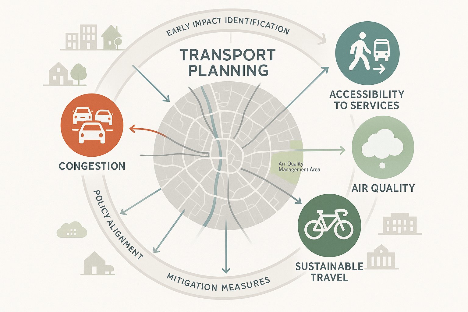
Transport planning is central to development in Worcester because the acceptability of a site is not judged only by land use, design or viability. It is also judged by whether people can reach it safely and efficiently, and whether the proposal creates unacceptable impacts on the surrounding network.
Under the South Worcestershire Development Plan, transport and access are core planning considerations. In practice, that means local authorities and highway officers will look closely at congestion, road safety, accessibility to services, air quality, and the extent to which a scheme supports sustainable travel choices. A development that works on paper but overloads nearby junctions, worsens conditions in an Air Quality Management Area, or leaves future users dependent on the private car is likely to face problems.
Worcester is especially sensitive because its network has a mix of strategic routes, constrained urban streets and heavily used radial corridors. Once pressure builds at the wrong junction, delays can spread quickly. And because many sites are tied into existing neighbourhoods, schools, employment areas and the city centre, transport effects are rarely isolated.
That’s why good transport planning in Worcester is not just about producing a report to satisfy validation requirements. It is about identifying impacts early, aligning with policy, and shaping a scheme so that access, mitigation and travel behaviour all work together. Done well, it reduces planning risk. Done poorly, it can undo an otherwise strong application.
Worcester’s Growth Context And What It Means For Planning Applications
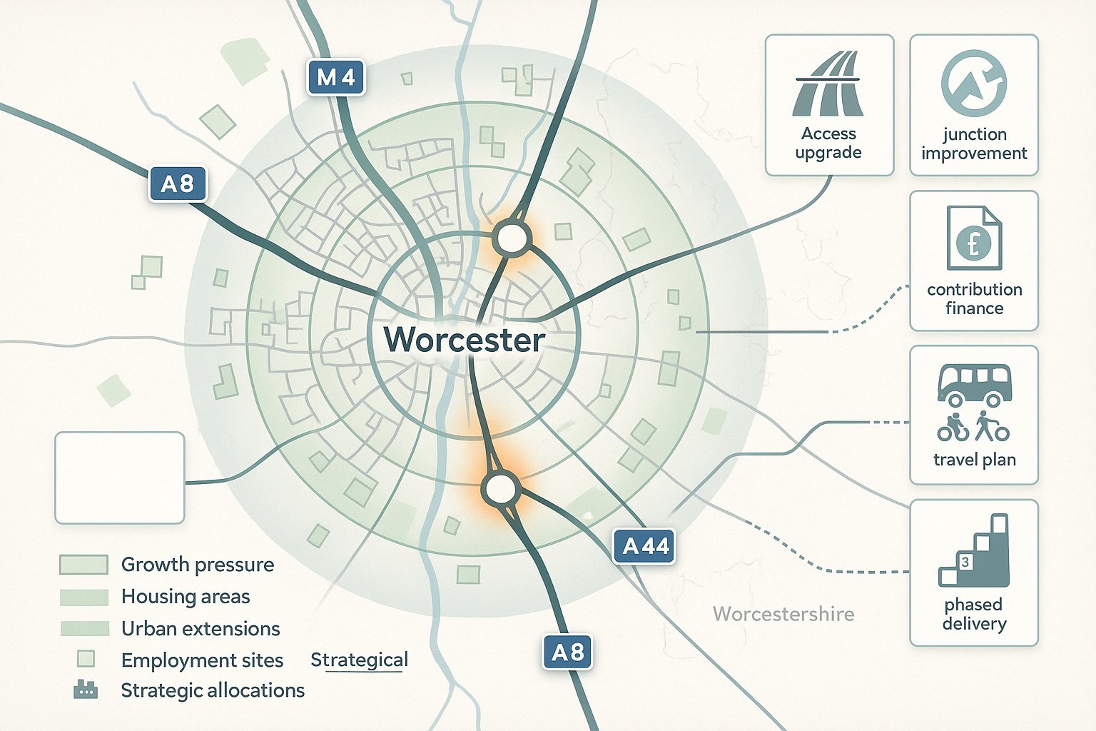
Worcester is not planning in a vacuum. The city and wider South Worcestershire area have been expected to accommodate significant housing and employment growth for years, and that growth has very real transport consequences. Strategic allocations, urban extensions and employment sites near the motorway all place additional demands on a network that already experiences peak-hour stress.
For applicants, the key point is this: planning applications are assessed in the context of cumulative growth, not just the trips generated by a single red line boundary. If nearby allocations, committed schemes or consented developments are likely to alter traffic conditions, those flows usually need to be considered. Highway authorities will often want to know not simply whether a site access works today, but whether it still works once background traffic growth and local build-out are taken into account.
This is particularly relevant around major corridors and interfaces with the strategic road network, including routes feeding the M5. Junctions 6 and 7, along with parts of the A38, A44 and A449 corridors, can become focal points for scrutiny because they affect both local movement and wider connectivity.
The practical implication is that mitigation may be needed even where a proposal’s direct impact looks modest at first glance. That might involve access improvements, off-site junction works, financial contributions through Section 106 mechanisms, Travel Plan measures, or a phased strategy linked to occupation. In short, Worcester’s growth agenda creates opportunity, but it also raises the evidential bar for transport submissions.
The Role Of Worcestershire County Council And Worcester City Planning Policy
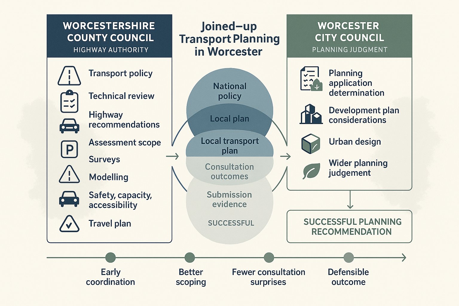
One of the most important distinctions in transport planning in Worcester is understanding who does what. Worcestershire County Council is the local highway authority, so it leads on transport policy, technical review and highway recommendations on planning applications. Worcester City Council, meanwhile, determines most planning applications within the city and applies the development plan and local material considerations, taking advice from the county on transport matters.
That division matters because a successful submission must satisfy both policy and technical expectations. At policy level, applicants need to demonstrate alignment with the National Planning Policy Framework, Planning Practice Guidance, the South Worcestershire Development Plan and relevant county transport strategies such as Worcestershire’s Local Transport Plan. At technical level, the submission must give the highway authority enough evidence to conclude that the development is acceptable in terms of safety, capacity, accessibility and operation.
In practical terms, Worcestershire County Council will often comment on assessment scope, survey methodology, modelling tools, visibility standards, access geometry, parking arrangements, servicing and Travel Plan content. Worcester City Council will consider those comments alongside broader planning issues such as design, sustainability and place-making.
The schemes that tend to progress more smoothly are the ones where this relationship is understood early. We generally advise teams to treat county and city requirements as part of a single joined-up planning exercise, not as separate hurdles. That usually leads to better scoping, fewer surprises in consultation, and a clearer route to a defensible recommendation.
When A Transport Assessment Or Transport Statement Is Likely To Be Required
Not every planning application in Worcester needs a full Transport Assessment, but many schemes require more than a brief transport note. The question is usually one of scale, sensitivity and likely impact.
In broad terms, a Transport Assessment (TA) is typically expected for larger or higher-impact proposals: sizeable residential schemes, retail development, schools, employment sites, mixed-use proposals and schemes in locations where the network is already under pressure. National Planning Practice Guidance gives threshold indicators, but local context is often just as important. A development below a national threshold may still need a TA if it sits near a constrained junction, affects a strategic corridor, or has unusual trip characteristics.
A Transport Statement (TS) is more common for smaller but still material proposals. These are schemes where impacts are not expected to be severe, but where the authority still needs evidence on access, trips, parking, servicing and sustainable travel. In Worcester, a TS is often appropriate where there are known local issues, even if the development is relatively modest.
Worcestershire County Council is likely to take a closer interest where proposals affect the M5 junctions, key radial routes into the city, strategic bus corridors, park-and-ride interfaces, or walking and cycling connections to nearby services. The requirement can also be triggered by cumulative impacts rather than site scale alone.
The best approach is not to guess. Early scoping with the highway authority can save weeks later on.
Key Elements Of A Transport Planning Assessment In Worcester
A robust transport planning assessment in Worcester usually combines policy analysis, field evidence, technical modelling and a practical mitigation strategy. The exact scope will vary by site, but certain components appear again and again because they address the questions decision-makers routinely ask.
First comes the policy framework: national policy, Planning Practice Guidance, the South Worcestershire Development Plan, Worcester City considerations and Worcestershire transport policy. That policy review should do more than quote paragraphs. It should explain what the scheme must prove.
Next is the baseline. This includes traffic counts, queue observations, speed surveys where needed, collision data, public transport availability, walking and cycling links, and existing parking or servicing conditions. If the baseline is weak, the whole assessment becomes vulnerable.
From there, the assessment usually moves into trip generation, distribution and assignment using recognised sources such as TRICS, together with a clear account of committed development and future year assumptions. Junction modelling may then be needed using tools such as PICADY, ARCADY or LINSIG depending on junction type.
Access design, visibility, internal circulation, parking provision, servicing arrangements and swept-path analysis are often critical too. And increasingly, sustainable travel measures are not an appendix afterthought: they are a central part of the argument.
At its best, a Worcester transport assessment tells a coherent story: this is the site, this is how people will reach it, this is the impact, and this is why the proposal remains acceptable.
Parking, Servicing, And Vehicle Manoeuvring Requirements
Parking and servicing can look like detailed design issues, but in Worcester they often become planning issues very quickly. A development may have acceptable traffic generation overall and still run into trouble if vehicles cannot enter, turn, serve or leave the site safely and efficiently.
Local parking expectations tend to reflect context. Central and highly accessible locations may support lower provision, especially where good walking, cycling and public transport links exist. Peripheral or less connected sites often require a more conventional level of parking. The key is evidence. If a scheme proposes a car-light approach, it needs a genuine accessibility case and usually a credible Travel Plan to match.
Servicing is just as important, particularly for commercial, mixed-use, education and apartment-led schemes. Refuse collection, delivery activity, maintenance vehicles and emergency access all need to be considered. We regularly see avoidable delays where a layout works for cars but not for a refuse vehicle or rigid HGV.
That is why swept-path analysis matters. It demonstrates whether the proposed geometry, aisle widths, turning heads and loading areas are functional in reality, not just attractive on a layout drawing. Highway officers will also look at forward gear movement, reversing risks, pedestrian conflict and whether servicing blocks parking aisles or access routes.
EV charging provision is now part of the conversation too. In 2026, it is no longer a nice extra. It should be integrated early so that parking design, power infrastructure and user expectations are aligned.
Common Worcester Transport Constraints That Affect Development Proposals
Worcester has several transport constraints that repeatedly shape planning outcomes, and ignoring them is one of the fastest ways to weaken an application.
The first is peak-hour congestion on key radial routes and at strategic junctions. Routes feeding the city and motorway network can experience limited spare capacity, especially where signalised junctions and roundabouts are already operating near practical limits. Even relatively modest additional trips can hence trigger scrutiny if they arrive at the wrong place and time.
The second is air quality sensitivity. Parts of the city have long-standing concerns linked to traffic concentration, particularly nearer the centre. Where a scheme risks increasing delay, stop-start traffic or routing through sensitive corridors, transport evidence may need to sit alongside broader environmental considerations.
Then there is Worcester’s physical form. Historic streets, narrow frontages, constrained junctions and established built fabric can make access design far more challenging than a simple standards exercise suggests. You may have visibility limitations, limited space for turning, or a tension between parking demand and public realm quality.
Accessibility is also uneven. Some locations are well served by buses, walkable routes and cycle connections: others, especially parts of the fringe or more disconnected suburban areas, are not. That affects what can realistically be said about mode share and parking restraint.
In short, Worcester is not usually a place where generic transport reporting works. Local constraints matter, and they need to be reflected in the evidence from the outset.
How To Prepare A Strong Transport Submission For A Planning Application
The strongest transport submissions are rarely the longest. They are the ones that are properly scoped, locally aware and easy for officers to follow.
Start early with Worcestershire County Council and, where relevant, Worcester City planning officers. Agreeing the study area, survey dates, future year scenarios, modelling approach and likely mitigation framework at the beginning can prevent major disagreements later. It also helps avoid the classic problem of producing a technically detailed report that still misses something the authority considers fundamental.
Use current and defensible data. That means recent traffic surveys, realistic peak periods, transparent trip assumptions and an explicit review of committed developments. If local circumstances have changed because of nearby schemes, road layout changes or emerging growth, the submission should say so plainly.
A strong report also demonstrates alternatives. Authorities increasingly expect applicants to show how walking, cycling, bus access and Travel Plan measures have been embedded in the design, not simply mentioned after a car-based layout has been fixed. That could involve better pedestrian desire lines, safer crossings, cycle parking in the right place, or contributions to nearby bus stop improvements where justified.
Clarity matters more than people sometimes think. Good drawings, legible appendices, concise tables and a non-technical summary can make a real difference for planning officers, committee members and third parties trying to understand the case.
And yes, it helps to use consultants who understand local thresholds and authority preferences. Experience saves time.
Frequent Issues That Delay Approval And How To Avoid Them
Most transport-related delays in Worcester are not caused by one dramatic flaw. They come from a collection of smaller weaknesses that erode confidence in the submission.
A common issue is under-scoping. Perhaps the report models one access junction but omits a nearby signal junction where queues already stack back in the peak. Or it assesses AM traffic but not the school-related PM period that local officers know is problematic. These gaps invite further information requests and can reset programme expectations almost overnight.
Outdated or poorly explained data is another regular problem. If survey information is old, taken in unusual conditions, or not validated against local observations, the authority may question the entire analysis. The same applies to trip rates that look selectively optimistic or that fail to include committed development flows.
We also see sustainable travel treated too lightly. Weak pedestrian links, awkward cycle access, missing crossing points or a generic Travel Plan with no targets or monitoring mechanism can all undermine the planning balance. Worcester authorities increasingly expect genuine mode-shift thinking, not box-ticking.
Parking can cut both ways. Too little, and overspill concerns appear. Too much, and the scheme may conflict with accessibility and sustainability objectives. Without evidence, either position is vulnerable.
The best way to avoid delay is simple, though not always easy: scope carefully, use current data, explain assumptions, test the right junctions, and make sure the mitigation directly responds to the impacts you’ve identified.
Conclusion
Effective transport planning in Worcester comes down to realism. The network is constrained, growth pressures are ongoing, and local policy is clear that development must do more than just avoid severe highway harm. It must also support safer, more sustainable patterns of movement.
For applicants, that means starting early, understanding Worcestershire County Council’s likely concerns, and producing evidence that is technically robust but also practical and readable. A strong Transport Assessment or Transport Statement should not merely quantify trips: it should show how the proposal fits its location, how impacts will be managed, and how people will be given credible alternatives to driving.
That is where experienced local reporting can make a meaningful difference. At ML Traffic, the emphasis is on concise, accurate transport engineering reports shaped around local authority thresholds and real planning contexts. And in Worcester, that kind of grounded approach is often what turns a transport submission from a planning risk into a planning asset.
Transport Planning in Worcester: Frequently Asked Questions
What is the importance of transport planning for development in Worcester?
Transport planning ensures developments in Worcester are accessible, safe, and policy-compliant. It helps manage congestion, air quality, and supports sustainable travel, preventing unacceptable impacts on the local and strategic highway network.
When is a Transport Assessment or Transport Statement required in Worcester?
A Transport Assessment is generally needed for larger or higher-impact developments such as sizable residential schemes, schools, or retail projects, especially near congested areas. Smaller proposals with material impacts may require a Transport Statement, particularly if affecting key routes or junctions.
How do Worcestershire County Council and Worcester City Council collaborate on transport planning?
Worcestershire County Council sets transport policy and leads technical reviews as the local highway authority, while Worcester City Council handles planning applications and applies development policies, consulting the county on transport to ensure submissions meet both policy and technical standards.
What are common transport constraints that affect development proposals in Worcester?
Worcester faces peak-hour congestion on key radial routes and M5 junctions, air quality issues near the city centre, historic narrow streets limiting access, and uneven public transport and active travel options, all of which must be addressed in transport planning submissions.
How should developers prepare a strong transport planning submission for Worcester?
Developers should engage early with local authorities to agree survey and modelling scope, use up-to-date traffic data including committed developments, demonstrate sustainable travel alternatives, and produce clear, well-evidenced reports linking mitigation directly to identified impacts.
What role does sustainable travel play in transport planning in Worcester?
Sustainable travel is prioritised through policies that promote walking, cycling, and public transport over private car use. Developments are expected to provide safe active travel links, contribute to local transport improvements, and implement Travel Plans to encourage mode shift and reduce car dependency.