Winchester is one of those places where transport planning looks straightforward on a location plan and decidedly less simple once you get into the detail. A site may sit close to the city centre, a rail station or a strategic route, yet the real planning questions quickly become more nuanced: can people reach it safely on foot, how will vehicles turn and service it, what happens at nearby junctions in the peak, and does the evidence actually match what Hampshire County Council and Winchester City Council expect to see?
That matters because transport planning in Winchester rarely gets judged on traffic numbers alone. Historic streets, conservation sensitivities, strong walking activity, commuter flows, tourism and growth pressures all shape the way applications are reviewed. A weak scope, an undercooked Transport Statement or a generic Travel Plan can slow validation, trigger rounds of technical queries, or in some cases undermine an otherwise sound proposal.
In this guide, we set out the practical side of Transport Planning in Winchester for architects, planners, developers, surveyors, lawyers and councils preparing planning submissions in 2026. We focus on when a Transport Assessment or Transport Statement is needed, what local policy and validation requirements mean in practice, the technical issues authorities usually scrutinise, and the common mistakes that cause delay. Where relevant, we also reflect the value of concise, authority-specific reporting – the kind of approach we prioritise at ML Traffic when supporting planning teams across Hampshire.
Why Transport Planning Matters For Development In Winchester
Transport planning is often treated as a supporting discipline, something to be commissioned once the layout is nearly fixed. In Winchester, that approach can be expensive. Access constraints, parking expectations, servicing needs and sustainable travel requirements can shape the developable area, the form of frontage, and even the overall scale of a scheme.
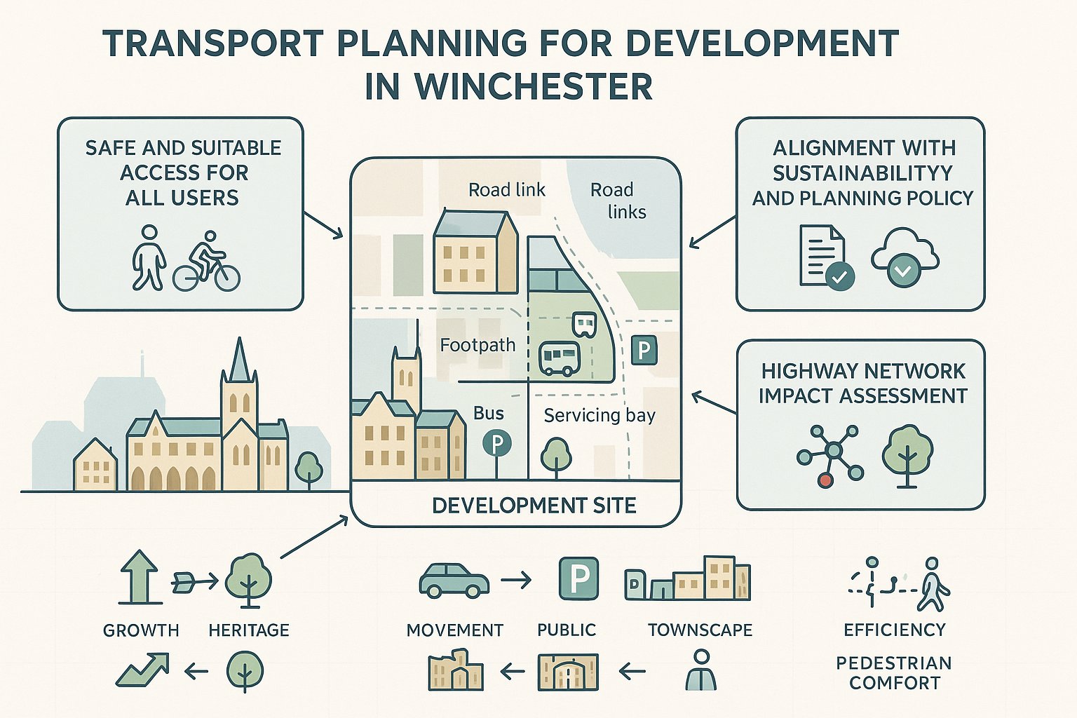
At planning stage, good transport evidence does three jobs at once. First, it shows that a development can be accessed safely and suitably by all users, not just drivers. Second, it helps decision-makers understand whether the proposal would place unacceptable pressure on the local or wider highway network. Third, it demonstrates alignment with broader policy aims around carbon reduction, air quality, place-making and healthier travel choices.
That last point is increasingly important. Under the National Planning Policy Framework (NPPF), development should promote sustainable transport modes, provide safe and suitable access, and only be refused on transport grounds where the residual cumulative impacts are severe. In practice, the word severe gets a lot of attention, but so does the quality of the evidence used to reach that conclusion.
For Winchester schemes, transport planning also helps reconcile competing objectives: growth versus heritage, movement versus public realm, parking demand versus townscape, and operational efficiency versus pedestrian comfort. When done well, it is not just a defensive report. It is a design and planning tool that can materially improve the prospects of consent.
The Winchester Context: Historic Streets, Growth Pressures, And Travel Demand

Winchester has a transport character all of its own. It is a compact historic city with narrow streets, sensitive frontages, constrained junctions and strong pedestrian activity, especially in and around the centre. Those qualities make it attractive, but they also limit how easily the network can absorb change.
Many sites are affected by conditions that do not show up neatly in a desktop review. A right turn may be technically possible but operationally poor. A servicing manoeuvre may fit on a swept path drawing yet feel wholly out of place in a tight heritage street. A short walking route to the station may involve gradients, narrow footways or awkward crossings that matter greatly in accessibility terms.
On top of that, Winchester experiences persistent growth pressures. Strategic development in and around the district, including large housing allocations and employment growth, adds demand to key corridors and junctions. The city also functions as a commuter destination and interchange point, with the rail station, bus services and park-and-ride sites playing an important role in daily travel patterns.
Tourism adds another layer. Peak conditions are not driven solely by weekday commuters: retail, leisure and visitor activity can alter parking demand, walking movements and town-centre servicing needs. For transport planning in Winchester, that means context is not a box-ticking exercise. We need to understand how the site sits within a living network that is constrained, busy and highly sensitive to poor design assumptions.
When A Transport Assessment Or Transport Statement Is Needed
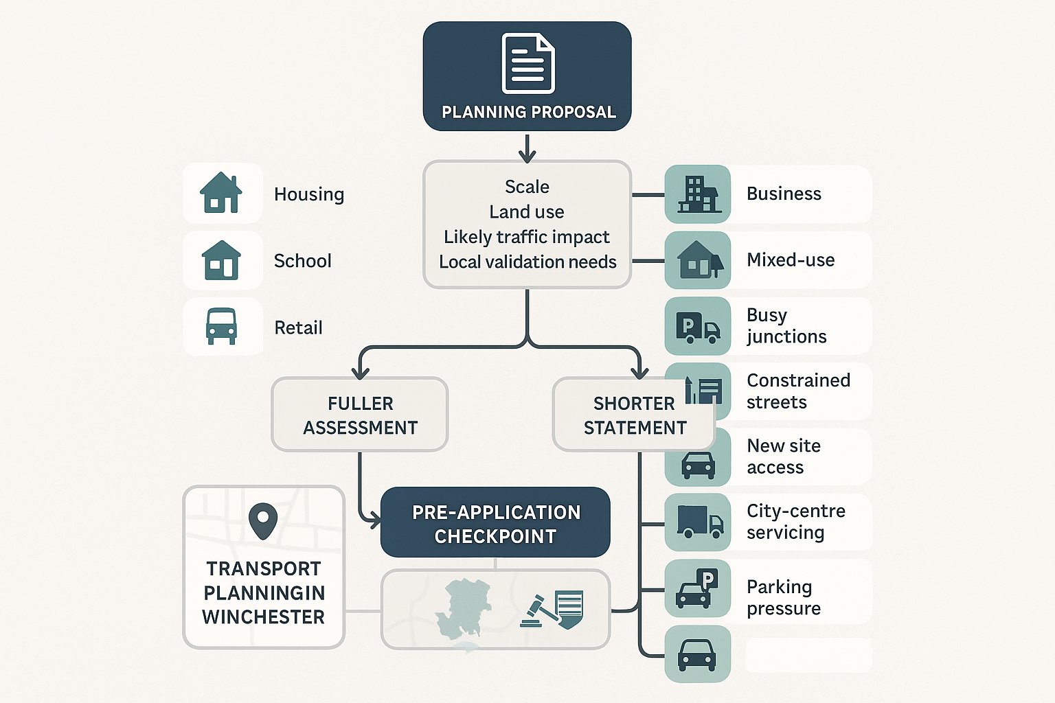
Whether a planning application needs a Transport Assessment (TA) or Transport Statement (TS) depends on scale, land use, likely impact and local validation expectations. There is no single national threshold that works in every case, which is why early scoping with the highway authority is so valuable.
The starting point is national policy and the Department for Transport’s guidance on transport assessment. Broadly, a Transport Assessment is expected for larger or impact-intensive developments – major housing, schools, sizeable retail, business or mixed-use schemes, and proposals likely to affect busy junctions or sensitive corridors. A Transport Statement is usually appropriate for smaller developments with more limited transport implications, where a proportionate narrative and targeted analysis can properly address the likely effects.
But proportionate does not mean superficial. In Winchester, relatively modest schemes can still require careful evidence if they sit in constrained locations, involve a new access onto a busy route, alter servicing in the city centre, or raise local parking stress. Conversely, not every small scheme needs extensive modelling.
As a rule, we advise teams to confirm scope at pre-application stage with Hampshire County Council as local highway authority, particularly where there is any doubt over study area, survey requirements or whether junction modelling is likely to be expected. That early agreement can save weeks later. It also reduces the risk of preparing the wrong document – one of the most avoidable reasons applications run into delay.
How Local Validation Requirements And Planning Policy Shape Evidence
In Winchester, the technical report is only part of the picture. The application also has to satisfy local validation requirements and respond credibly to the policy framework that officers and consultees will use in assessing it.
Winchester City Council’s local validation checklist is central here. It can determine whether a TA, TS, Travel Plan, access information, parking details or other supporting material is required before the application is even validated. If those documents are missing, too generic, or inconsistent with the submitted drawings, the process can stall before the merits are fully considered.
Policy then shapes content. At national level, the NPPF remains the key reference point on sustainable transport, safe access and severe impacts. Locally, the development plan, emerging plan context where relevant, parking standards, climate-related policies and accessibility expectations all influence the evidence base. Hampshire County Council’s design guidance, highway advice and approach to standards also carry weight, especially on access geometry, visibility, parking layout, turning, and the realism of active travel measures.
This is where local tailoring matters. A report that might pass muster elsewhere can struggle in Winchester if it ignores heritage constraints, assumes over-optimistic mode share shifts, or sidesteps local parking and servicing concerns. We find the strongest submissions are usually the clearest ones: concise, policy-aware, and explicit about how the evidence has been scoped to local authority expectations rather than copied from a previous project.
Key Transport Planning Documents Used In Winchester Applications
Most Winchester planning applications with transport implications revolve around three core documents. They overlap, but each serves a distinct purpose. Understanding the difference helps project teams commission the right evidence at the right time.
Transport Assessment
A Transport Assessment is the more comprehensive document. It sets out baseline conditions, describes the site and surrounding transport context, estimates trip generation, considers trip distribution and assignment, reviews access arrangements, and assesses likely effects on junctions, links and sustainable modes. Where impacts are identified, it also explains mitigation and residual effects.
For Winchester schemes, a good TA is rarely just a stack of appendices. It needs to tell a coherent story: why the assumptions are appropriate, why the study area is proportionate, and why the mitigation would work in a constrained local environment. If modelling is included, the narrative should still be readable by planning officers and committee members, not only technical reviewers.
Transport Statement
A Transport Statement is lighter-touch, but it should still be evidence-led. It normally describes existing conditions, access arrangements, forecast trips, parking provision, servicing and any focused mitigation, without the full breadth of analysis expected in a TA.
The trap with a TS is underestimating what proportionate means. A short report can be perfectly acceptable if the proposal is genuinely low impact. It becomes a problem when a TS is used to avoid addressing issues that are obviously material – nearby congestion, constrained access, or pressure on parking and loading, for example.
Travel Plan
A Travel Plan sets out measures to encourage sustainable travel by residents, staff, visitors or pupils, depending on the land use. It may include welcome packs, cycle facilities, public transport information, car club measures, appointment of a Travel Plan coordinator, monitoring arrangements, and target mode shares.
In Winchester, Travel Plans are often secured by condition or legal agreement. That means they need to be practical and enforceable. Generic promises about encouraging cycling are not enough. Authorities will usually want to see specific measures, monitoring periods, targets and triggers for review. The best Travel Plans reflect the realities of the site rather than recycling standard wording.
The Core Technical Issues Reviewed By Planning And Highway Authorities
When officers and highway engineers review a transport submission, they are typically testing a fairly consistent set of questions – though the emphasis varies by site.
First comes policy compliance. Does the proposal align with the NPPF, local plan policies, parking standards and relevant design guidance? If a scheme departs from standards, is there a robust place-based justification?
Second is safe and suitable access. Can vehicles enter and leave without creating undue risk? Are pedestrians, cyclists and disabled users properly accounted for? Is visibility adequate? Can service, refuse and emergency vehicles manoeuvre acceptably? If adoption is proposed, are the design details compatible with likely highway authority expectations?
Third is network effect. The authority will consider whether the development’s transport impacts, alone and cumulatively, would materially worsen operation at nearby junctions, links or sensitive locations. This is not simply about daily traffic totals. Peak-hour concentration, turning patterns and interaction with existing stress points often matter more.
Fourth is sustainable travel realism. Are walking, cycling and public transport opportunities genuinely available and attractive, or merely asserted? Are routes safe, direct and inclusive? Is the Travel Plan meaningful?
And finally, there is deliverability. Proposed mitigation has to be technically feasible, fundable and capable of implementation. A report may identify a crossing, parking restraint or access amendment in principle, but if land control, geometry or third-party approvals are doubtful, officers will notice. In short, the review is as much about credibility as technical competence.
Access, Parking, And Servicing Considerations For Different Site Types
Different land uses trigger different transport concerns, and Winchester’s constraints tend to sharpen them.
For residential development, authorities will usually examine vehicular access geometry, pedestrian links, internal layout, turning for refuse and emergency vehicles, parking provision, cycle storage and EV charging. Overspill parking can be especially sensitive near existing residential streets or close to the centre, where on-street capacity may already be under pressure.
For retail and leisure uses, the practicalities of customer arrival, short-stay parking, servicing and peak-time activity are often central. A unit that appears modest in floorspace can still generate concentrated parking turnover or awkward delivery activity. In historic or central locations, the question is often less “can vehicles get in” and more “can they do so without undermining pedestrian priority or townscape quality?”
For employment uses, trip profiles may vary by shift pattern, visitor activity and freight demand. Staff parking, disabled spaces, cycle provision, HGV routing and servicing hours can all be material. Warehouse and industrial proposals, in particular, need a realistic view of swept paths, waiting space and conflicts between heavy vehicles and more vulnerable users.
And for town-centre or heritage sites, subtlety matters. Loading may need to be timed rather than expanded. Parking restraint may be acceptable if accessibility is strong. In these locations, a compact, well-argued strategy often performs better than a standards-led one that ignores the setting. Transport planning in Winchester is rarely one-size-fits-all: site type and urban context have to be read together.
Sustainable Travel Expectations: Walking, Cycling, Public Transport, And Accessibility
Sustainable travel is not an optional extra in modern planning submissions. In Winchester, it is usually a central part of the case for development, especially where highway capacity is constrained and local policy places weight on healthier, lower-carbon travel.
For walking, authorities generally want to see continuous and direct routes to local services, schools, bus stops and other everyday destinations. That includes crossing opportunities, footway widths, surface quality, gradients and legibility. A route may be short on paper but poor in reality if it involves narrow pinch points, severance or awkward crossings.
For cycling, secure and convenient parking is the baseline, not the whole answer. Reviewers also look at whether the site connects sensibly to local routes and whether junctions or access points create unnecessary conflict. In some cases, calmer street environments or targeted link improvements are more useful than ambitious but unrealistic cycling claims.
For public transport, proximity matters, but so does quality. Walking routes to stops or stations need to be safe and attractive, services need to be reasonably useful for the development type, and any proposed contributions should be justified and specific.
Then there is accessibility in the wider sense. Inclusive design should run through the whole submission: step-free routes where possible, usable gradients, dropped kerbs, crossing design, disabled parking, and layouts that work for wheelchair users, pushchairs and visually impaired people. If sustainable travel measures are not inclusive, they are not genuinely sustainable. That is a point authorities increasingly make, and rightly so.
Junction Capacity, Safety, And Network Impact: What Supporting Analysis May Be Required
Not every application in Winchester needs detailed modelling, but many schemes do require some form of analytical support beyond a descriptive statement. The right package depends on scale, sensitivity of location, and what has been agreed at scoping stage.
A typical starting point is survey data – manual classified turning counts, automatic traffic counts, parking beat surveys, queue observations or pedestrian/cycle counts, depending on the issue. Data needs to be recent, representative and clearly tied to the assessment periods used.
Where junction impact is material, capacity modelling may be needed. That could include PICADY for priority junctions, ARCADY for roundabouts, LINSIG for signal junctions, or other tools suited to the local network question. The purpose is not to drown the authority in software outputs: it is to test whether development traffic would cause unacceptable increases in delay, queueing or operational stress.
A road safety review may also be expected, often informed by collision data, site observations and design checks on visibility, crossing provision or speed environment. If access changes are proposed, safety reasoning needs to be clear and specific.
Some schemes also require construction traffic assessment or a construction management approach, particularly where routes are constrained, neighbours are sensitive, or the site sits close to schools or pedestrian-heavy streets.
The common theme is proportionality with discipline. Supporting analysis should answer the real question at hand – and no more – but it must do so robustly. Thin evidence can be just as risky as excessive, unfocused technical material.
Common Reasons Transport Planning Submissions Run Into Difficulty
Most problematic submissions do not fail because transport issues are impossible to solve. They fail because the evidence is poorly scoped, locally tone-deaf, or too generic to withstand scrutiny.
One common problem is the wrong study area. Key junctions are omitted, nearby constraints are ignored, or only the most convenient peak hour is assessed. Another is weak or outdated data – surveys collected at the wrong time, not aligned with agreed methodology, or no longer representative of conditions on the ground.
We also see applications stumble over local standards and validation requirements. Parking layouts may not work operationally. Cycle stores may be technically provided but unusable. Access drawings and the written report may contradict each other. Or the submission simply misses documents the local checklist expects, leading to validation delays or immediate requests for further information.
Then there are sustainable travel claims that read better than they function. Mode share assumptions can be over-optimistic. Travel Plans can be generic and unenforceable. Public transport references may ignore actual service quality or first/last-leg conditions.
Finally, servicing and access design are frequent pressure points, especially in constrained Winchester locations. A delivery vehicle that blocks pedestrian movement, a refuse vehicle with no practical turning solution, or an access that works only if everybody behaves perfectly – those issues quickly undermine confidence.
In our experience, the best way to avoid trouble is simple: scope early, align with local authority expectations, and produce concise evidence that genuinely engages with the site. That sounds obvious. It is. But it is also where many applications come unstuck.
Transport planning in Winchester rewards precision. If the submission is proportionate, policy-aware and grounded in how the place actually works, planning success becomes much more likely. And if it is not, even a promising scheme can spend months answering questions that should have been resolved before submission.
Transport Planning in Winchester – Frequently Asked Questions
What is the role of transport planning in development projects in Winchester?
Transport planning ensures new developments in Winchester can be safely and efficiently accessed by all users, protects the local and strategic road network, and supports policy goals on carbon reduction, air quality, and promoting healthier, sustainable travel choices.
When is a Transport Assessment (TA) or Transport Statement (TS) required for planning applications in Winchester?
A Transport Assessment is generally needed for larger or impact-intensive developments such as major housing, schools, or retail schemes. Smaller projects with limited transport effects may require a proportionate Transport Statement. Scoping with Hampshire County Council at pre-application stage helps determine the appropriate document.
How do Winchester’s historic streets and growth pressures affect transport planning?
Winchester’s compact historic centre, narrow streets, and conservation areas limit highway capacity, making access and servicing challenging. Growth in housing and employment adds demand on busy roads, while strong pedestrian activity and tourism peak pressures require sensitive, context-aware transport solutions.
What key issues do planning and highway authorities review in transport planning submissions in Winchester?
They assess policy compliance, safe and suitable access for all users, whether development traffic causes severe residual cumulative impacts, realism and delivery of sustainable travel measures, and the technical and practical feasibility of proposed mitigation.
What sustainable travel considerations are essential in Winchester transport planning?
Plans must promote walking with safe, direct routes and good crossings; provide secure cycle parking connected to local routes; ensure quality public transport access; and incorporate inclusive design for all users including those with disabilities, reflecting local policies and national guidance.
Why do some transport planning submissions face delays or difficulties in Winchester?
Common issues include poorly scoped assessments missing key junctions or peak hours, outdated or insufficient survey data, failure to meet local parking and access standards, unrealistic sustainable travel claims, unsafe servicing designs, weak or unenforceable Travel Plans, and failure to satisfy local validation requirements.