In Lancaster, a planning application can look perfectly sound on paper and still stall once transport questions start landing. Can vehicles enter and leave safely? Will a nearby junction stack traffic back at peak times? Is the site genuinely walkable, cyclable, and reachable by bus, or does that claim fall apart under scrutiny? Those points often decide whether an application moves forward smoothly or gets bogged down in requests for further evidence.
That is why Transport Planning in Lancaster matters so much in 2026. For architects, planners, developers, surveyors, and local authorities, transport evidence is no longer a box-ticking exercise. It is a core part of showing that development can be accommodated by the surrounding network without creating unacceptable effects on congestion, safety, accessibility, parking, or servicing.
We see this regularly across Lancashire. The strongest applications are usually the ones that tackle transport early: they test access before layouts are fixed, use realistic trip and parking assumptions, and align their reports with local authority expectations from the start. With more than 30 years’ experience preparing concise transport reports for planning applications, we know that early clarity saves time, fees, and friction.
This guide explains the local context, the issues that most often affect Lancaster sites, when a Transport Statement or Transport Assessment is likely to be needed, and how to prepare evidence that is more likely to stand up to review.
Why Transport Planning Matters For Development In Lancaster
Transport planning sits at the point where design ambition meets operational reality. A site may be allocated, commercially attractive, and supported in principle, but if it cannot be accessed safely or if its traffic impact has not been properly understood, the application becomes vulnerable.
In Lancaster, this is especially important because development often has to fit into an established network with local pinch points, sensitive frontages, and routes that already serve several competing demands. A proposal does not need to create gridlock to become problematic: a modest increase in turning movements, poor visibility at an access, or unconvincing sustainable travel measures can be enough to trigger objections or delays.
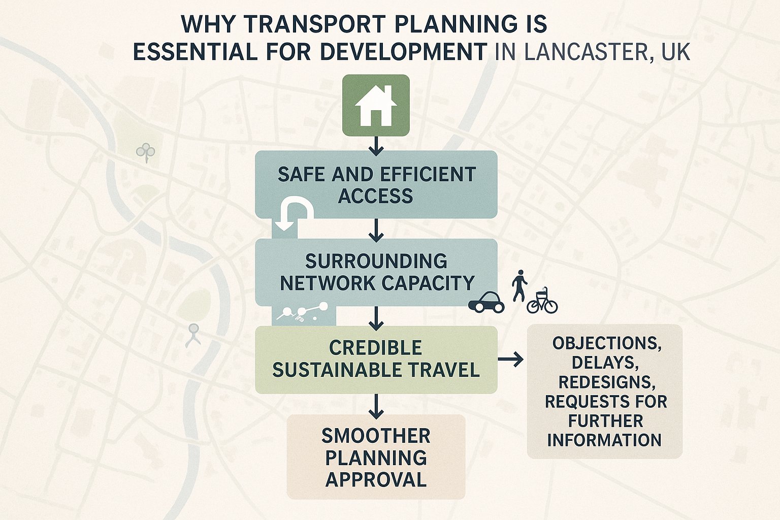
Good transport planning helps answer three practical questions early:
- Can the site be accessed safely and efficiently?
- Can the surrounding network accommodate the development?
- Does the scheme support a credible pattern of sustainable travel?
If those questions are addressed from the outset, the whole planning process tends to run better. Layouts are more realistic. Highways comments are more focused. Mitigation can be designed in rather than bolted on late.
For project teams, that means fewer redesigns and a stronger planning narrative. For councils, it means clearer evidence on whether the development is acceptable. And for applicants, it often means a better chance of avoiding the dreaded “please provide further transport information” letter that quietly adds months to a programme.
The Local Planning And Transport Context In Lancaster
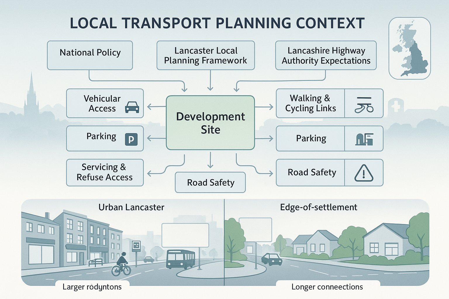
Transport planning in Lancaster is shaped by a mix of national policy, local plan requirements, and the expectations of the highway authority in Lancashire. In simple terms, applicants need to show that a proposal is suitable for its location and that its transport effects are acceptable, or can be made acceptable through mitigation.
That sounds straightforward. In practice, local context matters a lot.
Lancaster’s planning framework places weight on connected communities, accessibility, and reducing unnecessary car dependence. So transport evidence usually needs to go beyond vehicle impact alone. We would normally expect site appraisals to address:
- vehicular access arrangements
- nearby junction performance
- walking and cycling links
- public transport availability
- parking provision
- servicing and refuse access
- road safety considerations
The character of Lancaster also means context can vary sharply from one site to another. Urban sites near established bus routes and local services may be judged very differently from edge-of-settlement or more car-dependent locations. A scheme in a constrained built-up area may have to work harder on servicing, swept paths, and parking management. Meanwhile, greenerfield or expansion sites often attract greater scrutiny around junction impact and sustainable connectivity.
That is why we always recommend aligning transport evidence with local authority thresholds and the specific planning context of the site, not just generic national assumptions. A report that is technically competent but tone-deaf to Lancaster’s local transport issues is rarely as persuasive as it should be.
Key Transport Issues That Commonly Affect Lancaster Sites
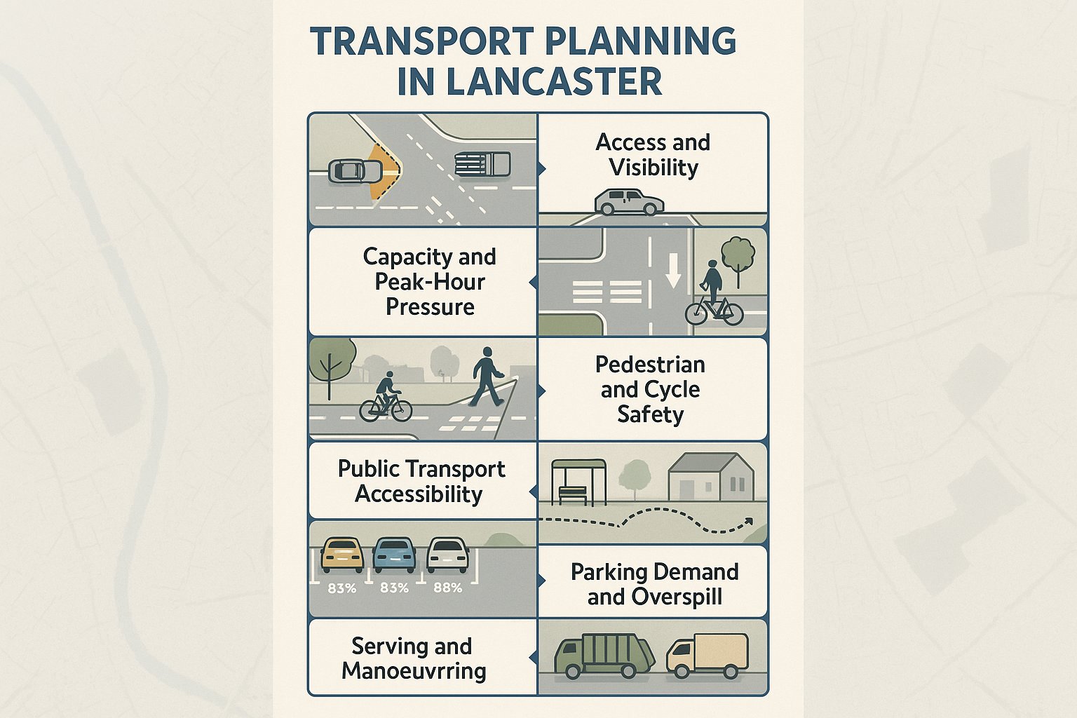
Certain transport issues come up again and again on Lancaster planning applications. They are not exotic technical traps: they are the recurring points that decision-makers and consultees look for because they often determine whether a scheme works in the real world.
First is access and visibility. Can drivers emerge safely? Are there conflicts with pedestrians or cyclists? Is the proposed access geometry suitable for the vehicles expected to use it?
Second is junction capacity and queueing. Even relatively small developments can become contentious if they feed traffic into already pressured junctions at the wrong time of day. Peak-hour interaction matters more than headline daily totals.
Third is pedestrian and cycle safety. A site may be close to services “as the crow flies”, yet still function poorly if the walking route is indirect, crossings are weak, or cyclists are pushed into uncomfortable traffic conditions.
Fourth is public transport accessibility. If bus stops are distant, infrequent, or disconnected from the site entrance, claims about sustainable travel start to look optimistic.
Then there is parking demand and overspill. Underprovide and neighbouring streets may object loudly. Overprovide and the sustainability story weakens. The right balance depends on use, location, and likely user behaviour.
Finally, servicing and refuse manoeuvring often catches applicants out. Delivery vehicles need to enter, turn, and leave safely without awkward reversing or conflict with residents, customers, or staff.
Most transport objections in Lancaster are built from some combination of these issues rather than one dramatic single flaw.
When A Transport Assessment Or Transport Statement Is Needed
Not every planning application needs a full Transport Assessment, but many developments in Lancaster will need at least some form of transport evidence. The key question is whether the proposal is likely to create material effects on traffic, access, safety, or travel patterns.
Broadly speaking, a Transport Statement is used where impacts are expected to be limited and can be explained proportionately. A Transport Assessment is more detailed and is normally required where a scheme is larger, more traffic-intensive, or more complex in transport terms.
That need can arise because of:
- the scale of development
- the type of land use
- constrained or unusual access arrangements
- likely peak-hour trip generation
- sensitivity of nearby junctions
- existing road safety concerns
- parking or servicing pressures
In other words, it is not just about floorspace or dwelling numbers. A smaller proposal on a difficult site may justify more evidence than a larger one in a highly accessible location.
We usually advise teams to confirm scope early, ideally before a detailed layout is fixed. That allows the right surveys, baseline data, and access testing to be commissioned in time. It also reduces the risk of producing a report that is technically correct but not what the case officer or highway authority actually wanted.
And yes, this happens more often than it should.
A short scoping discussion at pre-application stage can save a surprising amount of time. If the authority expects junction modelling, a travel plan framework, or swept path analysis, it is far better to know that before submission than after the first round of consultation.
How Trip Generation And Traffic Impact Are Evaluated
Trip generation is the starting point for most transport assessments. The exercise is simple in principle: estimate how many journeys a development is likely to create, identify when they occur, and then test what those movements mean for the surrounding network.
The detail, though, matters a great deal.
A robust assessment will normally consider the proposed land use, local travel characteristics, comparable survey data, and the site’s level of accessibility. For residential schemes, the focus is often on weekday commuter peaks. For commercial development, trading patterns, staffing, delivery activity, and customer demand may all influence the profile. Mixed-use schemes add another layer because some trips may be linked internally or spread differently across the day.
Once trip rates are agreed, the next steps usually include:
- assigning trips across the road network
- comparing them with existing and committed flows
- identifying which junctions or links should be assessed
- testing peak period effects on operation and delay
This is where weak reports often unravel. If trip rates are cherry-picked, if pass-by or internal trip assumptions are too optimistic, or if committed development has been ignored, the credibility of the whole assessment starts to wobble.
In Lancaster, where network performance can be sensitive at particular locations, we generally favour transparent assumptions and clear justification over aggressive forecasting. A slightly conservative assessment that is well explained is often more persuasive than a “best-case” model that invites challenge.
Transport planning in Lancaster works best when applicants show their workings, not just their conclusion.
Junction Capacity, Access Design, And Highway Safety Considerations
Once development traffic has been estimated, attention usually turns to whether the network and the site access can operate safely and effectively. This is where technical detail starts to influence planning risk quite directly.
Junction capacity assessments look at how additional movements affect delay, queueing, and reserve capacity at key points on the network. The right study area matters. Too narrow, and important effects may be missed. Too broad, and the report becomes noisy and unfocused.
Access design then examines whether the site entrance is fit for purpose. Typical questions include:
- Is visibility adequate in both directions?
- Is the geometry suitable for expected vehicle types?
- Can vehicles enter and leave without conflict?
- Are pedestrian routes protected and legible?
- Does the design work in wet weather, darkness, and busy periods, not just on a drawing?
Highway safety should never be treated as a token paragraph. Existing collision patterns, observed behaviour, speed environment, crossing demand, and interactions with cyclists all matter. A technically compliant access can still perform poorly if driver behaviour or local street conditions are not properly understood.
For Lancaster sites, safety concerns often overlap with layout and placemaking. Tight frontage conditions, multiple user types, school-related traffic, and constrained carriageways can all complicate what first looked like a straightforward access solution.
The best assessments do not just state that an arrangement is safe: they demonstrate why, with evidence, tracking, visibility checks, and a design rationale tied to the way the site will actually operate.
Sustainable Travel Expectations For New Development
In 2026, sustainable travel is not an optional flourish in a planning submission. It is a core test of whether development supports a more connected and less car-dependent pattern of movement.
Lancaster’s policy context places clear emphasis on active travel and accessibility. That means applicants are generally expected to show more than the presence of a nearby bus stop or a token cycle store. The question is whether future users can make practical, safe, and attractive non-car journeys from day one.
A credible sustainable travel strategy often includes:
- direct pedestrian links from the site to surrounding streets
- safe and convenient cycle access
- public transport routes within reasonable reach
- secure cycle parking and supporting facilities
- travel plan measures scaled to the development
- layout choices that make walking the obvious short-trip option
This is especially important where the traffic case is tight. Strong sustainable travel provision can help reduce car trip assumptions and support the broader planning balance, but only if the measures are realistic.
We have seen many submissions overclaim here. A route that looks short on a plan may involve poor crossings, steep gradients, weak lighting, or severance from a busy road. Decision-makers know the difference between theoretical accessibility and day-to-day usability.
So the objective is not to produce a fashionable sustainability section. It is to show that the development genuinely broadens travel choice in a way that fits Lancaster’s active transport ambitions.
Parking, Servicing, And Operational Layout Requirements
Parking and servicing are often where transport planning becomes very practical, very quickly. Even when the strategic traffic case is acceptable, a scheme can still struggle if the site does not function properly on the ground.
Parking provision needs to reflect the use, the accessibility of the location, likely user behaviour, and any local standards or authority expectations. Too little parking may lead to overspill, neighbour objections, and safety concerns on surrounding streets. Too much can consume valuable site area and undermine sustainable travel objectives.
But numbers alone are not enough. Layout matters just as much. We would usually test whether parking spaces are usable, whether aisles allow comfortable manoeuvring, and whether disabled bays, cycle parking, and electric charging provision are sensibly positioned.
Servicing is similarly important. The assessment should establish:
- what vehicles will serve the site
- how often they will arrive
- where loading or collection takes place
- whether turning can occur on site
- how refuse collection will operate
- whether servicing conflicts with occupiers or visitors
For residential schemes, bin collection strategy is a common weak point. For commercial schemes, delivery timing and loading bay management can be decisive. For mixed-use sites, there may be competing peaks that need to be separated by design or management.
Operationally efficient layouts do more than satisfy highways comments. They reduce future friction for occupiers, operators, and neighbours. That tends to make them worth getting right early.
Transport Planning For Residential, Commercial, And Mixed-Use Schemes
Different development types create different transport questions, so the evidence should reflect that rather than relying on a generic template.
For residential schemes, the emphasis is often on peak-hour trip generation, access safety, internal road layout, pedestrian links, parking demand, and refuse strategy. Family housing, apartments, and older persons’ accommodation can produce very different travel patterns, so comparability matters.
For commercial development, the operational picture is usually broader. Staff arrivals, customer turnover, servicing activity, delivery windows, and sometimes abnormal vehicle access all need attention. A light industrial unit, roadside use, office scheme, and foodstore may all sit under “commercial”, but they behave very differently in transport terms.
For mixed-use schemes, transport planning becomes more interesting and, frankly, more delicate. Multiple land uses interact across the day. Some trips are shared or internalised, while others stack on top of one another. Parking may need to serve different users at different times. Servicing may need careful separation from pedestrian areas. The benefit is that mixed-use development can support more sustainable local movement, but the evidence needs to prove that operationally.
In Lancaster, mixed-use proposals often need particularly clear explanation because they can promise wider planning benefits while also raising detailed questions on how the site will function.
This is one reason we tailor our reports to the authority, the land use, and the actual site constraints. A transport statement for ten houses should not read like one for an urban employment-led masterplan, and vice versa.
Common Reasons Transport Evidence Is Challenged During Planning
Most transport objections do not arise because applicants submitted nothing. They arise because the evidence submitted is not persuasive enough for the scale or sensitivity of the proposal.
Common problems include poorly justified trip generation, especially where survey data has been selected without explaining why it matches the proposed use or location. Authorities also challenge incomplete junction modelling, particularly when an assessment ignores nearby committed development or tests only one peak period.
Another frequent issue is weak access design evidence. Plans may show an access point, but without proper visibility assessment, tracking, speed data, or safety reasoning, consultees are left unconvinced.
Sustainable travel sections are also often challenged where the measures feel theoretical rather than usable. Saying a site is “accessible” is not enough if real walking, cycling, or bus journeys are awkward.
Other regular pressure points include:
- parking surveys that do not reflect local conditions
- servicing strategies that rely on impractical manoeuvres
- baseline data that is too old or incomplete
- mitigation that is vague, unfunded, or unsupported by design work
- reports that conflict with the submitted layout plans
Sometimes the issue is not the technical content itself but the way it is communicated. If the methodology is opaque, assumptions are buried, or conclusions jump ahead of the evidence, reviewers tend to probe harder.
In our experience, clarity is underrated. A concise report with sound logic usually travels further than a bulky one that leaves obvious questions hanging.
How To Prepare Stronger Transport Reports For Lancaster Applications
Stronger reports usually begin before the report writing does. They start with early site review, realistic design testing, and a clear understanding of what the local authority is likely to want to see.
For Lancaster applications, we recommend a few practical disciplines.
First, establish scope early. Confirm whether a Transport Statement, Transport Assessment, travel plan material, junction modelling, road safety review, or swept path analysis is likely to be required.
Second, use site-specific evidence wherever possible. That may include recent traffic counts, parking surveys, accessibility audits, or operational observations. Generic assumptions can be useful, but local data is usually harder to argue with.
Third, make assumptions explicit. Explain trip rates, distribution, modal assumptions, servicing patterns, and mitigation logic clearly. If a judgment call has been made, say so and justify it.
Fourth, align the transport work with the design team. Access, parking, bin storage, cycle parking, and internal layout should all tell the same story across the application set.
Fifth, engage early with the highway authority where appropriate. A short pre-application conversation can flush out concerns before they become formal objections.
This is very much how we approach projects at ML Traffic: concise reporting, locally aware thresholds, and evidence that is proportionate but robust. Not every scheme needs a 100-page assessment. Quite a lot need a sharper 20 pages with the right technical content.
That balance is usually what makes transport planning in Lancaster more efficient.
What To Consider Before Submitting A Planning Application
Before submission, the best question is not “Do we have a transport report?” but “Have we answered the transport risks this site is likely to face?” That shift in mindset catches a lot of avoidable problems.
We generally suggest a final pre-submission check against six core points:
- Need for evidence – Have we confirmed the right level of transport reporting?
- Access feasibility – Does the proposed access work geometrically and safely?
- Junction impact – Have we assessed the right locations with credible assumptions?
- Parking and servicing – Will day-to-day operation work without overspill or conflict?
- Active and public transport provision – Are walking, cycling, and bus links genuinely usable?
- Mitigation and commitments – Are proposed works, management measures, or travel plan actions realistic and deliverable?
It is also worth checking consistency across the application package. Highway comments often pick up contradictions between transport reports, site plans, landscape drawings, and design statements. A swept path that works on one drawing but not another is the sort of thing that creates instant doubt.
If there is a sensitive issue, address it directly. Do not hope it slides by unnoticed. A frank explanation with evidence is almost always better than silence.
Done properly, pre-submission review turns transport from a planning vulnerability into a controlled part of the application strategy. That is usually the difference between a smooth consultation and a long one.
In short, good preparation is not glamorous, but it gets schemes over the line.
Transport Planning in Lancaster: Frequently Asked Questions
Why is transport planning important for development in Lancaster?
Transport planning ensures that new developments can be served by the local network without causing unacceptable congestion, safety risks, parking issues, or accessibility problems. It is critical in Lancaster due to existing traffic pressures and the need to support sustainable travel options.
When is a Transport Statement or Transport Assessment required for a planning application in Lancaster?
A Transport Statement is needed for developments with limited transport impact, while a more detailed Transport Assessment is required for larger, more traffic-intensive, or complex proposals, especially where site access or local junctions may be affected.
What are the key transport issues commonly considered in Lancaster planning applications?
Common issues include safe and visible site access, junction capacity and peak-hour queueing, pedestrian and cycle safety, public transport accessibility, parking demand and overspill, and servicing and refuse vehicle manoeuvring.
How does Lancaster’s transport planning support sustainable travel?
The local planning framework emphasises active travel and connected communities by expecting developments to provide safe, direct, and practical walking, cycling, and public transport links that encourage reduced car dependency from day one.
How can developers prepare stronger transport reports for Lancaster planning submissions?
Strong reports use early scoping to confirm evidence needs, site-specific data, clear assumptions, coordinated design and transport plans, and early engagement with the highway authority to ensure the evidence is proportionate, robust, and aligned with local expectations.
What should be checked before submitting a planning application involving transport in Lancaster?
Applicants should verify the need for transport evidence, assess access feasibility, evaluate junction impacts, ensure parking and servicing work operationally, confirm active and public transport links are usable, and provide realistic mitigation or travel plan commitments to avoid delays.