Planning in St Albans is rarely just about the red line boundary. On many schemes, the real pressure point sits outside the site: the junction that already queues at school-run time, the constrained historic street that was never designed for modern traffic, the station catchment under strain, or the local concern that another development will tip an already busy corridor over the edge.
That is exactly why Transport Planning in St Albans matters so much in 2026. For architects, developers, planning consultants, solicitors, surveyors and local authorities, transport evidence is often the difference between a smooth application and a drawn-out exchange with Hertfordshire Highways and the local planning authority. A report that is too generic, too late, or poorly scoped can create avoidable objections. A report that is proportionate, policy-aware and rooted in local conditions can do the opposite: reduce uncertainty and help a scheme move forward.
In our experience, St Albans applications succeed when transport work is treated as part of the design process, not a box-ticking exercise at the end. The local policy framework, network constraints, sustainable travel expectations and highway safety issues all need to be considered together.
In this guide, we set out the practical local requirements, the documents typically needed, how assessments are usually prepared, where objections tend to arise, and what teams can do from the outset to give an application the best chance of planning success.
Why Transport Planning Matters In St Albans
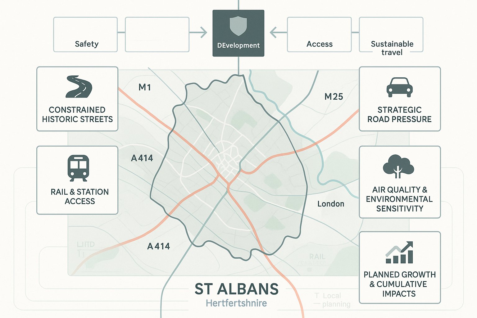
St Albans presents a transport planning challenge that is more nuanced than it may first appear. It has strong strategic connections, a prosperous commuter profile and attractive residential and commercial locations, but it also has constrained streets, busy peak periods and high expectations around design quality and sustainable travel. That combination means transport is often a central planning issue rather than a supporting technical note.
At application stage, transport planning helps answer the questions decision-makers actually care about: will the proposal operate safely, can the network accommodate it, are the access arrangements workable, does parking make sense, and have realistic alternatives to private car use been built into the scheme? Those questions run through everything from small infill developments to major mixed-use proposals.
For St Albans in particular, the stakes are higher because cumulative growth matters. Even where one development appears modest in isolation, officers and consultees will often consider how it sits within wider housing and employment growth, corridor pressure and local sustainability objectives. A robust submission hence needs to show not only what the development does, but why its effects are acceptable in context.
Well-prepared transport evidence also saves time. It can narrow the scope of debate, support negotiations on mitigation and prevent avoidable requests for further information. For teams working to programme and budget, that practical benefit should not be underestimated.
The Local Context That Shapes Transport Decisions
The local context in St Albans shapes almost every transport judgement. The district sits within the wider Hertfordshire transport framework, while the city itself has a historic urban form that limits easy highway widening or major geometric change. In plain terms, there often isn’t much spare room to solve a transport issue later.
A few local characteristics repeatedly influence assessments:
- Historic street pattern and constrained townscape: many routes are narrow, sensitive and already busy.
- Strategic road access: links to the M1, M25 and A414 increase connectivity but also concentrate demand on key corridors and junctions.
- Strong rail relationship with London: station access, parking pressure, walking routes and bus interchange can all become relevant.
- Air quality and environmental considerations: where congestion is already a concern, transport effects may attract closer scrutiny.
- Planned growth: Local Plan allocations and broader Hertfordshire strategies increase focus on cumulative impact and sustainable mode shift.
The St Albans Urban Transport Plan, the Hertfordshire Local Transport Plan, and the development plan framework all feed into decision-making. That means transport submissions should never be written as if the site exists in a vacuum. We need to show how a proposal responds to the real network, real policy priorities and real local patterns of movement.
When A Planning Application Needs Transport Input
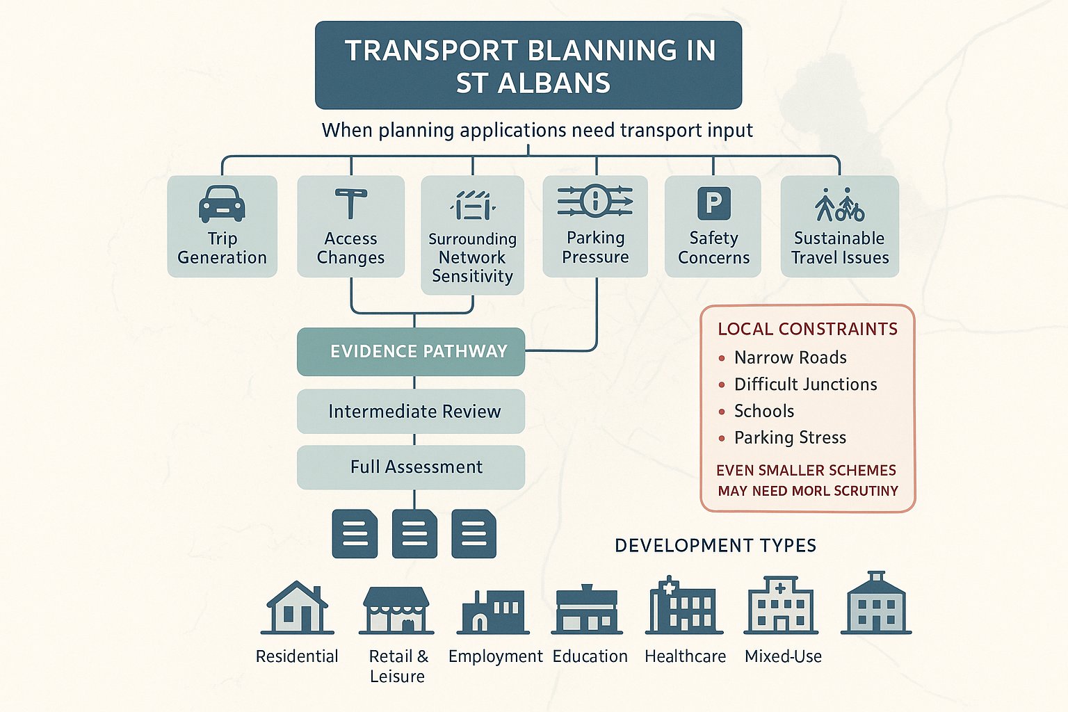
Not every planning application in St Albans requires a full technical package, but many need some form of transport input far earlier than applicants expect. The trigger is not simply development size. It is also about likely trip generation, access complexity, sensitivity of the surrounding network, parking implications, and whether the proposal could raise safety or sustainability concerns.
In practice, formal transport input is commonly required where a scheme is likely to generate noticeable travel demand, alter an access arrangement, intensify use of a site, or sit in a location where local constraints are already evident. Hertfordshire Highways, acting as the highway authority, will often expect proportionate evidence that follows national policy principles and local standing advice.
The National Planning Policy Framework remains the broad policy backdrop: transport issues should be considered from the earliest stages so that opportunities for sustainable movement, safe access and suitable mitigation are properly addressed. Locally, that principle translates into a need to agree scope early and avoid under-submitting.
For smaller schemes, transport input may be limited to access advice, parking review, swept-path analysis or a concise transport note. For larger or more complex proposals, a Transport Statement, Transport Assessment, Travel Plan, or a combination of those documents is usually expected.
A good rule of thumb is this: if transport could become a reason for delay, objection or redesign, it should be addressed before submission, not after validation.
Common Development Types That Trigger Assessment
Certain land uses regularly prompt transport review in St Albans because their traffic and travel patterns are harder to absorb without evidence.
Common examples include:
- Residential development, especially major housing sites, apartment-led schemes in accessible areas, or proposals with contested parking provision.
- Retail and leisure schemes, where peak demand, servicing activity and weekend traffic patterns can affect nearby junctions.
- Employment development, including offices, industrial sites and business parks with staff, visitor and delivery movements.
- Education uses, where school-run peaks and road safety issues often dominate the assessment.
- Healthcare proposals, which may generate dispersed but sensitive trip patterns and require strong accessibility planning.
- Mixed-use developments, where the interaction between uses, internal layout and cumulative demand needs careful explanation.
Even where thresholds do not obviously point to a full assessment, local circumstances can push a scheme into more detailed review. A modest proposal on a constrained road, close to a difficult junction, near a school, or within an area of parking stress may attract more highway scrutiny than a larger proposal in a straightforward location.
That is why we usually advise teams not to think in terms of “Do we technically need a report?” but rather “What level of transport evidence will make this application credible?”
Key Transport Planning Documents For St Albans Applications
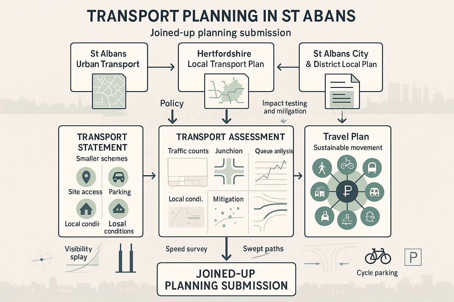
The transport documents required for a St Albans planning application should reflect both the scale of the proposal and the local policy context. In most cases, the technical work sits within a wider planning framework rather than standing alone. If the reports do not align with local strategy, they tend to feel incomplete even where the calculations are sound.
Three policy sources are especially important:
- The St Albans Urban Transport Plan, which identifies local transport issues, priorities and interventions.
- The Hertfordshire Local Transport Plan, which sets the county-wide strategy for movement, network management and sustainable travel.
- The St Albans City & District Local Plan and relevant supplementary guidance, which frame development expectations at district level.
Depending on the scheme, applicants may also need supporting technical drawings and appendices such as visibility splays, speed surveys, collision analysis, swept-path plans, junction modelling outputs and cycle parking schedules.
The key point is that transport documentation should tell one joined-up story. The policy context, baseline evidence, design response, impact testing and mitigation need to reinforce each other. If the access drawing says one thing, the parking layout suggests another, and the transport report glosses over both, the submission becomes vulnerable quickly.
Transport Statements, Transport Assessments, And Travel Plans Explained
These three documents are often mentioned together, but they do different jobs.
A Transport Statement (TS) is usually used for smaller or less traffic-intensive schemes. It provides a proportionate review of existing conditions, site accessibility, expected trip generation, access arrangements, parking and likely transport effects. The emphasis is on clear evidence without unnecessary modelling.
A Transport Assessment (TA) is more detailed and is typically required for larger or more complex proposals. It may include:
- surveyed baseline traffic conditions
- junction capacity modelling
- queue and delay analysis
- trip distribution and assignment
- cumulative impact testing
- mitigation proposals
A Travel Plan (TP) is different again. It focuses on behaviour, not just infrastructure. Its purpose is to encourage walking, cycling, bus use, rail use, car sharing and other non-single-occupancy-car choices by residents, staff or visitors. A strong TP usually includes measures, targets, management arrangements and monitoring.
In St Albans, the most effective submissions use these documents in a complementary way. The TS or TA explains the transport impacts and physical response: the TP shows how the development will support sustainable travel in practice. Together, they help demonstrate policy compliance and reduce the risk of the scheme being seen as car-dependent by default.
How St Albans Transport Planning Assessments Are Typically Prepared
A sound transport planning assessment is rarely produced in a single pass. In St Albans, the better approach is staged and evidence-led: first agree the likely scope, then build a realistic baseline, then test the effect of the development, and finally tie the findings back into design and policy.
At the start, we usually look at the site in local context rather than jumping straight into trip rates. That means understanding surrounding land uses, road hierarchy, walking catchments, cycle routes, bus and rail availability, school or commuter peaks, parking pressure and any known safety concerns. This is the point where many later problems can be avoided.
From there, the technical work typically progresses through data collection, trip generation, impact analysis and mitigation review. For more complex sites, pre-application engagement with Hertfordshire Highways and the local planning authority is especially valuable. It helps establish which junctions matter, what survey information is likely to be accepted, and whether cumulative development needs to be addressed in a particular way.
The overall aim is not simply to produce a compliant report. It is to produce one that is proportionate, locally grounded and difficult to dismiss. In our experience, concise and accurate reporting often carries more weight than a long document that avoids clear conclusions.
Existing Conditions, Trip Generation, And Impact Review
This is the core technical sequence behind most Transport Statements and Transport Assessments.
Existing conditions come first. That usually includes traffic counts, observed queueing, vehicle speeds, road geometry, visibility, parking conditions, walking and cycling facilities, bus services, rail accessibility, and often a review of personal injury collision data. The purpose is to establish what the network is doing now, not what we assume it does.
Trip generation comes next. Comparable sites, census-style data and industry tools such as TRICS are often used to estimate likely arrivals and departures. That assessment should reflect the actual characteristics of the scheme, including location, accessibility and probable mode split. Overstated assumptions can make a scheme look worse than it is: optimistic assumptions can undermine credibility.
Impact review then tests what those trips mean in practice. Depending on the proposal, that may involve:
- priority junction modelling
- roundabout or signal junction analysis
- queue and delay review
- operational assessment of access points
- internal circulation checks
- cumulative impact consideration alongside committed development
If impacts are identified, mitigation should be specific and workable. That might involve access amendments, visibility improvements, layout changes, travel plan measures, parking refinements, pedestrian links or contributions to off-site works. The key is to show that the development has been engineered with transport reality in mind, not simply defended after the fact.
Access, Parking, Servicing, And Road Safety Considerations
These four issues are where many planning applications become either convincingly practical or unexpectedly fragile.
Access must work safely and intuitively for all users. In St Albans, where streets can be constrained and frontage conditions irregular, the details matter: junction geometry, visibility splays, gradients, pedestrian priority, interaction with nearby parking, and whether vehicles can enter and leave without awkward manoeuvres. A technically possible access is not always a planning-acceptable one.
Parking often needs careful balancing. Too little parking can lead to overspill and local objection: too much can conflict with sustainable transport policy, weaken placemaking and consume valuable land. Car parking levels should hence be justified in relation to site accessibility, local standards, development type and likely user profile. Cycle parking deserves the same seriousness. Poorly located or token cycle stores rarely support genuine uptake.
Servicing is another common pressure point. Delivery vehicles, refuse collection, moving vans and emergency access all need to be considered. Swept-path analysis is often essential, particularly on tighter sites or mixed-use schemes. If servicing can only occur by blocking the highway or conflicting with pedestrian desire lines, objections are not far away.
Road safety ties the whole picture together. Collision analysis, design checks and route review help demonstrate whether the proposal introduces unacceptable risk. In many cases, safety concerns arise not from headline traffic growth but from poor layout detail: hidden exits, reversing movements, pedestrian conflict points, or awkward school-time interactions.
Good transport planning addresses these issues early, while the site layout is still flexible. Once a design is fixed, solving access or servicing problems tends to become slower, costlier and more political.
Walking, Cycling, Public Transport, And Sustainable Travel
In St Albans, sustainable travel is not a soft add-on to a planning submission. It is a core part of the transport case. That reflects both policy direction and local reality: many sites sit within reach of town centres, schools, bus routes or rail services, but the quality of the connection often determines whether people will actually use them.
A convincing submission should assess more than distance alone. We need to consider whether walking routes are direct, well lit, overlooked, step-free where necessary and comfortable at crossing points. For cycling, the same principle applies: nominal proximity is not enough if the route feels hostile or disconnected.
Public transport assessment should cover bus stops, service frequency, operating hours, rail station access and interchange quality. On stronger sites, these factors can materially support lower car reliance. On weaker sites, they may point to the need for mitigation or a more realistic parking and travel strategy.
Travel Plan measures can make a real difference when they are specific rather than generic. Useful examples include:
- welcome packs with local walking, cycling and public transport information
- personalised travel planning
- cycle parking and changing facilities
- car-club spaces where viable
- EV charging infrastructure
- discounted public transport incentives or travel vouchers
- monitoring and review mechanisms
The local policy objective is clear: new development should help manage growth without deepening congestion or car dependency. In St Albans, that means showing how a scheme connects to everyday destinations and how the design actively supports lower-impact travel choices. If sustainable transport is treated as an appendix issue, consultees usually notice.
Working With Hertfordshire Highways And The Local Planning Authority
Transport planning in St Albans works best when applicants understand the distinct but linked roles of the key public bodies involved.
Hertfordshire Highways, as highway authority, is a principal technical consultee on many applications. Its focus is usually on matters such as network impact, safety, access suitability, parking and servicing logic, and whether the submitted evidence is robust. If the methodology is weak or the baseline incomplete, that will usually surface here first.
The local planning authority then considers that transport advice alongside wider planning issues such as design, land use, amenity, heritage, sustainability and overall policy balance. In other words, a transport issue is rarely judged in isolation, but poor transport evidence can still undermine the whole planning case.
This is why early engagement matters. Pre-application discussion can help clarify:
- whether a TS, TA or TP is expected
- which junctions or routes should be assessed
- whether committed development needs to be included
- what survey periods and data sources are appropriate
- how access and parking principles should be framed
Not every point will be agreed in advance, and pre-app feedback is not a guarantee. But it usually reduces the risk of writing a report to the wrong scope.
For applicants and consultants, there is also a softer skill involved: presenting evidence in a way that is technically sound but easy to audit. Clear assumptions, transparent appendices, legible plans and direct conclusions help officers and consultees review the submission efficiently. That may sound obvious, but many delays arise because the information is there somewhere, just not where anyone can sensibly find it.
Where specialist support is needed, firms with local authority-facing transport report experience can often add value by keeping the analysis concise, targeted and aligned with the relevant Hertfordshire context.
Common Reasons Transport Planning Objections Arise
Most transport objections in St Albans are predictable. They usually stem from one of three problems: the development creates a genuine transport concern, the evidence has not adequately addressed a foreseeable issue, or the submission underestimates the importance of local policy and site context.
One of the most common objections is unacceptable residual cumulative impact. Even where a single scheme does not appear dramatic, its effect on already pressured junctions or corridors can become contentious, especially when combined with committed growth.
Another frequent issue is substandard access design. Poor visibility, awkward geometry, insufficient turning space or unresolved pedestrian conflict can quickly trigger highway safety concerns. These are often easier to resolve before submission than after objection.
We also see objections where the assessment itself is weak. Typical examples include:
- outdated or incomplete survey data
- incorrect trip rates or unrealistic mode split assumptions
- limited explanation of junction modelling inputs
- missing collision analysis
- no meaningful review of nearby walking or cycling conditions
Parking can go either way. Some schemes are challenged for under-provision, with fears of overspill onto surrounding roads. Others are criticised for over-provision, particularly where the location could support lower car use and the layout becomes dominated by vehicles.
Then there is the policy issue. If a submission does not engage properly with the Urban Transport Plan, the Local Transport Plan or the Local Plan, it may look technically competent but strategically tone-deaf.
The pattern is consistent: objections arise where transport work is generic, late or detached from design. Strong submissions tend to be the opposite, specific, transparent and rooted in the real characteristics of St Albans.
How To Strengthen A Planning Submission From The Start
The strongest transport submissions are usually built early, not rescued late. By the time an application is being assembled for submission, the main transport risks should already be understood and, ideally, designed through.
A practical starting point is to scope the work early with both the site team and, where appropriate, Hertfordshire Highways or the local planning authority. That helps identify whether the development needs a concise statement or a more detailed assessment, which junctions are likely to matter, and what supporting analysis should be prepared from the outset.
From there, a few principles consistently improve the quality of an application:
- Use current and relevant data. Old traffic counts or generic assumptions can weaken the entire submission.
- Design access, parking and servicing together. These elements should support each other rather than compete within the layout.
- Apply recognised tools properly. TRICS, swept-path software and junction modelling are useful only when their assumptions are explained and suited to the site.
- Align with policy. The St Albans Urban Transport Plan, Hertfordshire Local Transport Plan and Local Plan should be reflected in both the narrative and the design response.
- Prepare a tailored Travel Plan. Specific commitments, realistic targets and clear monitoring arrangements carry more weight than stock text.
- Be honest about constraints. A transparent explanation of trade-offs is usually more credible than pretending they do not exist.
For project teams working to tight timescales, specialist support can also make a measurable difference. At ML Traffic, for example, the emphasis is on concise, accurate transport engineering reports tailored to local authority thresholds and planning contexts, which is often exactly what a time-sensitive application needs.
Eventually, successful Transport Planning in St Albans comes down to fit: fitting the evidence to the scale of the proposal, fitting the design to the site, and fitting the whole submission to local policy and network conditions. When that happens, planning risk usually drops, and the application stands on much firmer ground.
Planning success in St Albans rarely turns on transport alone, but transport can absolutely decide the tone of an application. If the evidence is proportionate, locally informed and tied closely to the design, consultees are far more likely to engage constructively. If it is generic or reactive, problems tend to multiply.
For architects, planners, lawyers, developers and public-sector teams, the practical lesson is simple: treat transport planning as an early design discipline, not an end-stage report. Understand the local network, engage with policy, test the impacts honestly, and make sustainable travel measures real rather than decorative.
That approach does more than satisfy a consultee. It helps create schemes that work on the ground, for residents, businesses, visitors and the wider St Albans network. And in a district where growth, congestion and place quality are constantly in tension, that is what good planning should do.
Transport Planning FAQs for St Albans
Why is transport planning important in St Albans?
Transport planning in St Albans manages growth, congestion, and supports sustainable travel amidst historic street constraints, busy peak periods, and local air quality concerns. It helps ensure developments operate safely and fit within the wider network and policy context.
When does a planning application in St Albans require transport input?
Transport input is required for developments likely to generate significant travel demand, alter access arrangements, or be located on constrained roads. This includes larger housing, retail, employment, education, healthcare, or mixed-use schemes, following Hertfordshire Highways guidance and national policy.
What transport documents are typically needed for planning applications in St Albans?
Depending on scheme scale, a Transport Statement (TS) for smaller sites, Transport Assessment (TA) for larger schemes, and a Travel Plan (TP) promoting sustainable travel are commonly needed. These documents must align with the St Albans Urban Transport Plan, Hertfordshire Local Transport Plan, and Local Plan policies.
How are transport assessments prepared for St Albans developments?
Assessments start with scoping with Hertfordshire Highways and local planning authorities, followed by collecting baseline data on traffic, parking, and public transport. Trip generation is estimated using tools like TRICS, then impacts are modelled and mitigation proposed, with a strong focus on local context and sustainability.
What common transport-related objections arise in St Albans planning applications?
Objections often stem from cumulative traffic impact on busy roads, substandard access design, insufficient or excessive parking, weak sustainable travel measures, poor walking or cycling links, or failure to comply with local transport policies. Inadequate or outdated transport evidence also triggers concerns.
How can planning submissions be strengthened with regard to transport in St Albans?
Early engagement with Hertfordshire Highways and the local authority to agree scope, using up-to-date data and recognised modelling tools, designing for safe access, parking, and servicing together, and delivering a robust Travel Plan with clear targets all improve submission quality and reduce planning risks.