Cambridge is one of those places where transport planning is never just a box to tick. A modest scheme on paper can trigger detailed scrutiny once it meets a compact street network, heavy cycle flows, constrained parking, heritage sensitivities, and a clear policy push toward lower-carbon travel. For architects, planners, developers, lawyers, surveyors, builders, and local authorities, that means transport evidence needs to be proportionate, credible, and closely aligned with local expectations from the outset.
In practice, Transport Planning in Cambridge sits at the intersection of planning policy, highway safety, place-making, and development viability. The city’s growth ambitions are significant, but so is the expectation that new development will reduce car dependency, support walking and cycling, and work with public transport rather than against it. That balance is where many applications succeed or stall.
In this guide, we set out the practical side of the process in 2026: when a Transport Assessment or Transport Statement is likely to be needed, what supporting documents typically matter, how Cambridge’s travel patterns shape technical decisions, and where delays usually arise. We also draw on the realities of local authority thresholds and planning contexts that experienced transport consultants deal with every day. The aim is simple: help teams prepare stronger, faster, more defensible planning submissions in Cambridge and the wider Greater Cambridge area.
Why Transport Planning Matters In Cambridge
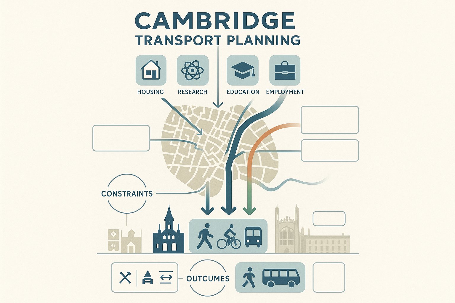
Cambridge places unusual pressure on transport strategy because it combines rapid growth with a street network that was never designed for high car volumes. The city is economically strong, land values are high, and demand for housing, research space, education, and employment floorspace continues to rise. But the transport network has real physical limits. Historic streets, sensitive junctions, constrained frontage access, and competing demands for road space all make movement a planning issue from day one.
That matters because planning decisions here are not based only on whether vehicles can technically enter and leave a site. They are shaped by wider outcomes: reducing congestion, improving air quality, protecting the historic environment, encouraging healthier travel choices, and supporting climate targets. In Cambridge, a development that relies too heavily on private car use can face resistance even if its highway impacts seem manageable on a narrow engineering reading.
The local policy direction is clear. New schemes are expected to prioritise walking, cycling, and public transport, and to demonstrate that sustainable access is practical, not theoretical. For some sites, that means rethinking parking assumptions. For others, it means proving that pedestrian routes are direct, cycle parking is genuinely usable, servicing is safe, and travel demand can be managed over time.
In short, transport planning in Cambridge is central to planning success because it affects policy compliance, scheme design, public acceptability, and delivery risk all at once.
The Local Planning And Policy Context
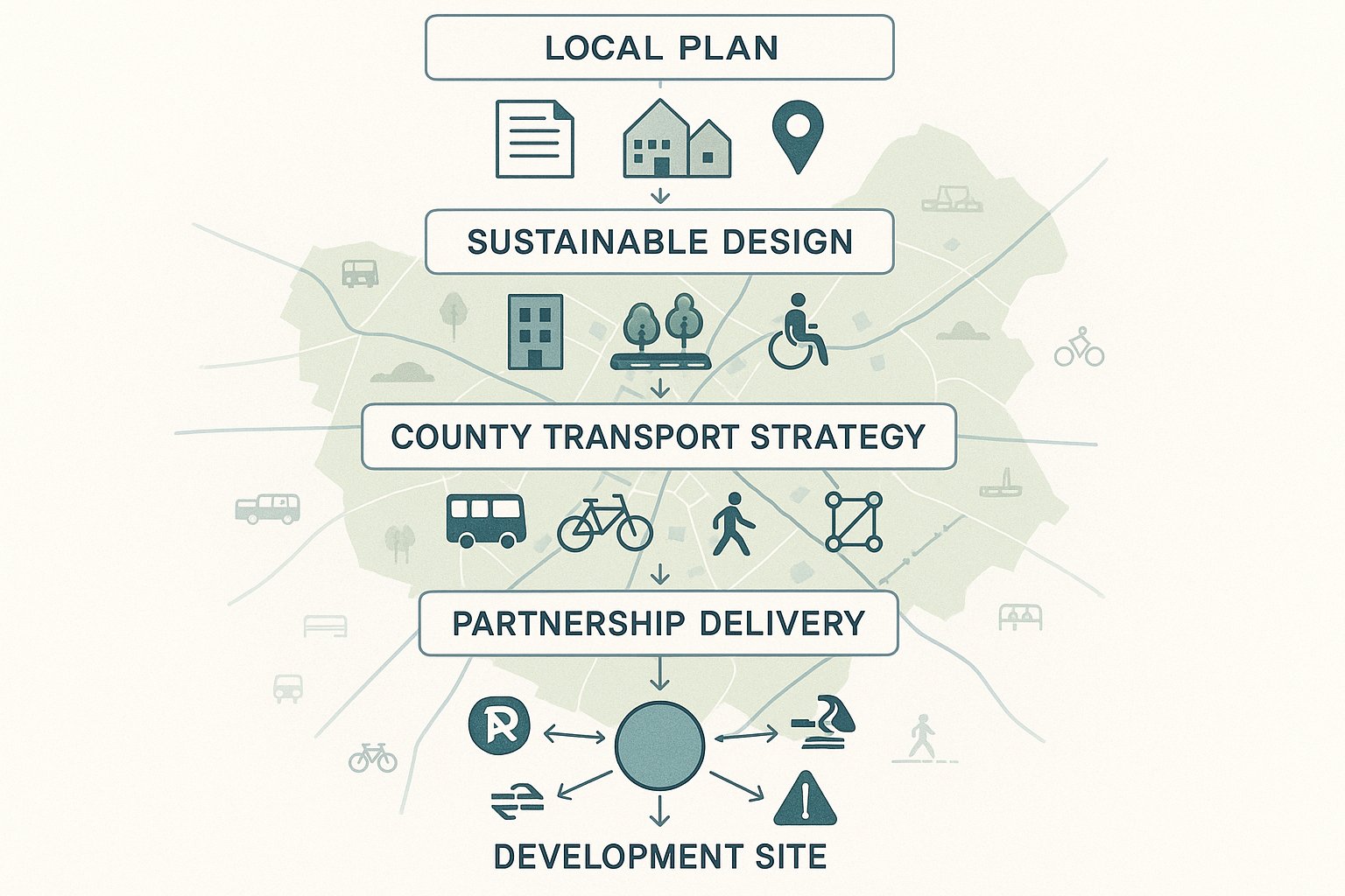
The policy framework in Cambridge is detailed, and applicants are expected to engage with it properly rather than cite it superficially. At the local level, the Greater Cambridge Local Plan and related supplementary guidance shape how movement, accessibility, and transport impacts are assessed. The Sustainable Design and Construction SPD, including its transport, movement, and accessibility content, is especially important because it connects development design with practical travel outcomes.
Alongside district planning policy, county-level transport policy carries real weight. Cambridgeshire’s transport plans, active travel strategies, and Local Cycling and Walking Infrastructure Plan help define what good looks like for access, route quality, and integration with the wider network. The Greater Cambridge Partnership programme also influences expectations by promoting sustainable transport interventions across the area, from corridor improvements to bus priority and walking and cycling infrastructure.
For applicants, the key point is this: Cambridge does not assess transport in isolation. A site may appear acceptable in purely geometric terms, yet still attract challenge if it fails to support mode shift or sits awkwardly with strategic transport objectives. That is why early policy review matters. We need to understand not just the land use allocation or planning history, but also whether the scheme aligns with local accessibility aims, parking restraint, and active travel priorities.
When we prepare reports, we treat policy as an operational tool, not a decorative appendix. Done well, policy alignment helps explain why a scheme is suitable, what mitigation is proportionate, and how transport impacts should be judged in context.
How Cambridge’s Travel Patterns Shape Development Decisions
Cambridge has travel characteristics that differ sharply from many UK towns and cities. Cycling levels are notably high, bus travel plays a major role on key corridors, and road capacity is limited. That combination changes how development proposals are reviewed. Assessors will often look closely at whether a scheme is designed around realistic local travel behaviour rather than default national assumptions about car use.
This has practical consequences. A residential or mixed-use scheme near strong cycle routes, employment areas, colleges, or frequent bus services may be expected to generate lower car mode share than an equivalent development elsewhere. But that lower car use cannot simply be asserted. It needs to be evidenced through site context, accessibility analysis, parking strategy, and the quality of active and public transport links.
Equally, constrained road capacity means even modest additional vehicle trips can become a concern at sensitive locations. In Cambridge, cumulative impacts matter. Officers may ask whether vehicle movements would affect already stressed junctions, bus reliability, pedestrian comfort, or cycle safety. So the question is rarely just “how many trips?” It is also “where, when, by what mode, and with what effect on a network already under pressure?”
Developments that respond well tend to do three things: minimise unnecessary car demand, make sustainable travel easy in everyday terms, and present a transport case grounded in local reality. That often makes the difference between a report that feels generic and one that helps move an application forward.
When A Transport Assessment Or Transport Statement Is Needed
Whether a Cambridge application needs a Transport Assessment (TA) or Transport Statement (TS) depends on scale, land use, likely transport effects, and site sensitivity. In broad terms, larger or more impact-intensive proposals usually require a TA, while smaller schemes with more limited implications may be supported by a TS. But in Cambridge, thresholds are only part of the story.
A site in a highly accessible urban location may still require detailed analysis if access is constrained, cycle flows are intense, servicing is awkward, or local parking pressure is already high. Equally, a relatively small scheme can attract transport scrutiny if it sits on a sensitive corridor, affects vulnerable road users, or proposes departures from normal parking expectations. Car-free and low-parking schemes are a good example: they may reduce highway impact, but they still need robust evidence on accessibility, mode share, and how travel demand will be managed in practice.
A TA normally goes further on trip generation, distribution, assignment, operational impact, mitigation, and cumulative effects. A TS is shorter and more proportionate, but it still needs to show that transport implications have been properly considered. Neither document should be treated as a template exercise.
The safest approach is early review of local policy, site context, and likely consultee concerns. In our experience, clarity at the beginning saves weeks later on, especially where applications involve mixed uses, phased delivery, unusual access arrangements, or constrained city-centre and edge-of-centre locations.
How Local Authority Thresholds And Site Context Affect Requirements
Published thresholds provide a starting point, not a guarantee. Local planning and highway authorities routinely consider whether the surrounding network, the proposed use, and local travel conditions justify more or less detail than a standard threshold table might suggest.
In Cambridge, context is everything. A student accommodation scheme near central cycle corridors will be looked at differently from an edge-of-settlement logistics use. A small infill development on a narrow street with limited visibility and resident parking stress may need more technical evidence than its unit count alone would suggest. Meanwhile, a well-located office scheme with excellent bus and cycle access may be able to support a restrained parking provision if the wider evidence is strong.
That means scoping is critical. We usually advise agreeing, as far as possible, the study area, baseline data, trip rates, survey requirements, and modelling expectations before drafting the main report. If this is left too late, applicants can end up revisiting fundamentals after submission, which is expensive and avoidable.
The best results come from proportionality. Authorities want enough evidence to understand the likely effects and secure mitigation where needed. They do not usually want unnecessary bulk. The challenge is judging where that line sits for the specific site, not for an imaginary average scheme.
Core Transport Planning Documents For Cambridge Applications
A strong transport submission in Cambridge is rarely just one report. The TA or TS is the backbone, but decision-makers often need a package of documents that explain how the site will function, how people will reach it, and how transport impacts will be managed through design and operation.
At minimum, many schemes will need a clear movement strategy embedded across the planning set. That can include the TA or TS, a Travel Plan, transport-related content within the Design and Access Statement, and technical notes dealing with issues such as junction capacity, swept path analysis, parking demand, cycle provision, delivery management, or construction effects. The exact mix depends on the scheme.
This is where coordination matters. A transport consultant can produce an excellent report, but if the site layout, landscape strategy, refuse collection arrangement, and planning statement all point in slightly different directions, problems follow. Cambridge officers and consultees will notice inconsistencies quickly, especially around access hierarchy, parking numbers, or sustainable travel commitments.
From a project management perspective, transport documents should be developed early enough to influence design, not merely justify it after key decisions are fixed. That sounds obvious, but it is still one of the most common reasons applications run into friction.
For firms needing concise, authority-aware reporting, this is exactly where experienced local transport input adds value. On complex or time-sensitive schemes, clear and accurate reporting at the right level of detail can materially improve the planning timetable.
Transport Assessment, Transport Statement, And Travel Plan
The Transport Assessment is the most comprehensive of the core documents. It typically explains existing conditions, accessibility, baseline travel choices, trip generation, distribution and assignment, parking and servicing arrangements, safety issues, and any mitigation needed to make the development acceptable. Where junction impacts are relevant, modelling or operational analysis may sit within or alongside it.
The Transport Statement is more concise, used for proposals where impacts are expected to be limited. But concise does not mean light on reasoning. A good TS still addresses accessibility, access design, likely trip effects, parking, cycle provision, servicing, and policy compliance in a way that is tailored to the site.
The Travel Plan deals with ongoing travel behaviour. In Cambridge, this can be particularly significant because policy emphasis is not just on infrastructure but on reducing car dependence over time. A useful Travel Plan sets measurable objectives, identifies site-specific measures, allocates responsibility, and explains monitoring and review. Generic promises are rarely persuasive.
Taken together, these documents tell the authority not only what impact the scheme may have, but how that impact will be managed in real life.
Supporting Technical Notes And Delivery Strategy Evidence
Supporting notes often carry more weight than applicants expect. If the main report states that parking demand will be acceptable, a parking survey or parking accumulation note may be needed to back that up. If refuse or servicing vehicles must turn within the site, swept path drawings and a delivery strategy become important. If the site affects a sensitive junction, local modelling or queue observations may be required.
Other supporting material can include speed surveys, visibility analysis, stage 1 road safety audit responses, cycling connectivity plans, public transport accessibility notes, construction traffic management principles, and servicing or logistics plans. For phased developments, delivery strategy evidence can be essential in showing how transport measures will align with occupation triggers.
In Cambridge, supporting evidence often matters most where a proposal is trying to do something slightly unconventional: reduced parking, constrained access, shared surfaces, car-free living, or a strong shift toward cycle-based access. Those approaches can absolutely succeed, but only when the evidence is coherent.
The point is not to produce paperwork for its own sake. It is to anticipate the questions officers, highway authorities, and sometimes neighbours are likely to ask, and answer them before they become objections.
Key Issues Assessed For Development Sites
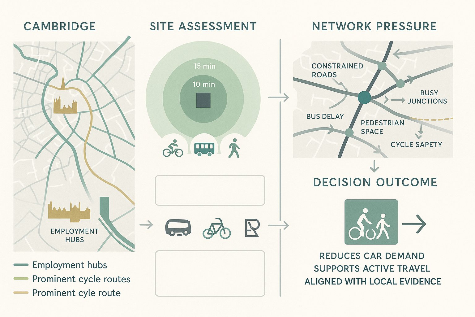
Transport review in Cambridge tends to focus on how a site will actually work day to day, not just on headline trip numbers. That includes whether people can reach the site safely and conveniently, whether vehicles can access and service it without conflict, and whether the overall arrangement supports local policy aims on sustainable travel.
The assessment is hence multi-layered. Highway geometry still matters, of course, but so do route quality, connectivity, parking behaviour, accessibility for disabled users, and the interaction between private vehicles, service vehicles, cyclists, and pedestrians. On some sites, the technical challenge lies in junction impact. On others, it lies in making a low-car or car-free proposition credible.
What Cambridge often does especially well, from a policy perspective, is look beyond the red line boundary. Authorities will want to know how the site connects into the surrounding network, whether nearby crossing points are adequate, how direct the cycle routes really are, whether bus stops are useful in practice, and whether the proposed layout will create friction for existing users.
That broader lens means transport planning needs to be integrated with urban design and site operation. A development can have a compliant access width and still perform poorly if cycle parking is hidden, servicing blocks pedestrian desire lines, or visitors end up circulating for parking. Those are the details that often shape technical responses.
Access, Parking, Servicing, And Road Safety Considerations
Access design is usually the starting point. Authorities will consider visibility, geometry, gradient, junction form, vehicle tracking, and whether different users can move safely through the site entrance. In Cambridge, where cycle movement can be intense and footway continuity matters, even a simple access can become a sensitive design issue.
Parking is another recurring pressure point. The headline number of spaces matters, but not in isolation. Officers will also ask how parking provision supports the proposed mode split, whether disabled and visitor parking is appropriate, how cycle parking is designed, and whether overspill risk has been honestly assessed. Underestimating local parking stress is a common own goal.
Servicing deserves the same level of attention. Can delivery vehicles enter, turn, wait, and leave safely? Will refuse collection block access roads or pedestrian space? Are loading arrangements realistic for the intended occupier? These questions can delay applications when left vague.
Road safety considerations cut across all of this. Recent collision history, conflict points, vulnerable user movement, visibility constraints, and design responses all need to be addressed proportionately. A scheme does not need to eliminate every risk, but it does need to show that risks have been understood and reduced through competent design.
Walking, Cycling, Public Transport, And Sustainable Travel
In Cambridge, sustainable travel is not a secondary chapter. It is often the heart of the transport case. Applicants are expected to show that walking, cycling, and public transport are practical first-choice options for the people who will use the development.
For walking, that means more than measuring distance. We need to consider directness, crossing opportunities, footway quality, lighting, overlooked routes, and whether key destinations can be reached comfortably by different users. A ten-minute walk can be acceptable on paper but unattractive in reality if the route is hostile.
Cycling analysis is equally important. Cambridge has strong cycling culture, so cycle parking quality, route continuity, junction comfort, and links to the wider network are all closely examined. Poorly located or awkward cycle stores can undermine an otherwise good strategy.
Public transport assessment should address access to stops, service frequency, route coverage, journey time usefulness, and the quality of connections. On some sites, bus accessibility will be a major strength. On others, it may need to be supplemented by Travel Plan measures, improved wayfinding, or contributions toward local enhancements.
What matters most is coherence. Sustainable travel claims need to match the physical design, management measures, and likely behaviour of future users.
The Transport Planning Process From Feasibility To Decision
The transport planning process works best when it starts before the planning application is assembled, not after. At feasibility stage, we should already be testing whether the access concept is workable, what the surrounding movement network looks like, where the likely pressure points are, and whether the proposed land use matches the site’s accessibility profile.
A typical process begins with site appraisal: existing highway conditions, walking and cycling links, public transport access, parking controls, collision history, servicing constraints, and any nearby junctions or corridors likely to be sensitive. That baseline work informs early design choices and helps avoid expensive redesign later.
The next step is usually scoping with planning and highway officers where appropriate. This is where study area, survey scope, trip methodology, scenario testing, and report type can be clarified. Not every detail will be formally agreed, but early dialogue often narrows the room for dispute.
Then comes preparation of the TA or TS, Travel Plan, and any supporting technical notes. The strongest submissions keep the story consistent across all documents: the site is accessible, the design reflects local policy, impacts are understood, and mitigation is proportionate and deliverable.
After submission, transport work rarely stops. Technical comments may require clarification, revised analysis, updated drawings, or negotiation over conditions and obligations. Sometimes that is straightforward: sometimes it is where programmes slip. Clear evidence, prompt responses, and realistic mitigation proposals usually make that stage far smoother.
For developers and consultants under time pressure, this is why quick, accurate and locally tailored reporting matters so much. It is not just about submission quality. It is about keeping the planning process moving.
Common Risks, Delays, And How To Strengthen An Application
Most transport-related delays in Cambridge are not caused by one dramatic flaw. They are caused by a series of smaller weaknesses that, together, make the authority lose confidence in the submission. A trip-rate assumption that feels too optimistic. A cycle route plan that ignores a difficult crossing. Parking that is numerically compliant but operationally awkward. A servicing strategy that exists only in theory.
One common risk is underestimating car demand or overspill effects, especially on lower-parking schemes. Another is relying on generic statements about sustainable travel without proving that the routes, facilities, and management measures are strong enough to support the claimed mode share. Late engagement with the highway authority is another regular problem. By the time concerns emerge through formal consultation, redesign can be expensive.
Applications are also weakened when transport evidence is internally inconsistent. If the Planning Statement promises one thing, the site plan shows another, and the TA quietly assumes something else, objections become more likely. Cambridge consultees tend to read across documents carefully.
So how do we strengthen an application? Start early. Scope properly. Use robust local data. Be honest about constraints. Design access and servicing around real operation, not idealised diagrams. Treat walking, cycling, and bus accessibility as core evidence, not a compliance add-on. And where mitigation is needed, make it specific, proportionate, and linked to the identified impact.
If there is one practical lesson from years of transport work, it is this: authorities are much more receptive when a report shows mature judgement. Not just technical competence, but evidence that the team understands Cambridge’s streets, policy priorities, and development pressures.
That is exactly where experienced support helps. At ML Traffic, the value is not simply producing a report quickly: it is producing one that is concise, accurate, and tailored to local authority thresholds and planning context. In a place as exacting as Cambridge, that difference can be decisive.
Good transport planning does not guarantee consent. But weak transport planning can absolutely put a viable scheme at risk. The better approach is to build the transport case early, align it with design and policy, and give decision-makers clear reasons to say yes.
Frequently Asked Questions about Transport Planning in Cambridge
Why is transport planning particularly important in Cambridge?
Transport planning in Cambridge is critical due to its compact, historic street network combined with rapid growth in housing, jobs, and research. The city’s policies prioritize reducing car dependency, improving air quality, and supporting walking, cycling, and public transport to meet climate and health goals.
When is a Transport Assessment or Transport Statement required for developments in Cambridge?
A Transport Assessment (TA) is needed for larger or more impact-intensive developments, while smaller or less impactful schemes usually require a Transport Statement (TS). However, local context, site sensitivity, and parking levels can influence this, and even small schemes may need detailed evidence if they affect sensitive areas or propose reduced parking.
How do Cambridge’s travel patterns influence transport planning for new developments?
High cycling levels, significant bus use, and limited road capacity in Cambridge mean developments must minimise car trips and provide practical sustainable access. Transport planning assesses realistic local travel behaviour, often expecting lower car mode share than in other cities, backed by evidence of accessibility, parking strategy, and quality of active travel links.
What key issues are usually assessed in transport planning submissions in Cambridge?
Submissions focus on access design, parking provision, servicing arrangements, and road safety, alongside walking and cycling connectivity, public transport accessibility, and integration with local policy priorities. Authorities also consider how a site connects to the wider network, impacts on vulnerable users, and whether sustainable travel options are practical and well supported by design.
How can developers strengthen their transport planning applications in Cambridge to avoid delays?
Early engagement with planning and highway authorities, using robust local data, agreeing on scope and methodology upfront, and providing coherent evidence across all documents improve applications. Clear mitigation strategies, realistic trip and parking assumptions, strong sustainable travel plans, and integration with local policies significantly reduce the risk of objections and delays.
What documents typically support transport planning applications in Cambridge?
Applications usually include a Transport Assessment or Transport Statement, a Travel Plan managing ongoing travel behaviour, a Design and Access Statement with movement evidence, and supporting technical notes such as junction modelling, parking surveys, servicing strategies, and cycle infrastructure plans to demonstrate compliance with local policies and technical requirements.