Getting a planning application over the line in Preston isn’t just about good architecture, viable layouts or a neat planning statement. If the transport case is weak, the whole proposal can slow down fast. We see it time and again: a scheme that looks sensible on paper gets stuck because traffic impacts weren’t scoped properly, the access strategy feels undercooked, or the supporting evidence doesn’t match what Preston City Council and Lancashire County Council expect.
That matters even more in 2026. Preston continues to balance housing delivery, employment growth, regeneration and movement across a network that includes the M6, M55, A6, A59 and A582, alongside busy local corridors, town-centre streets and established residential areas. In that setting, transport planning in Preston has become one of the practical make-or-break issues for developers, architects, planners and land teams.
The good news? Most transport objections are not mysterious. They usually come down to scope, timing, evidence quality and whether the submission reflects local policy and local highway realities. When we prepare transport reports, the aim is simple: give decision-makers confidence that a development can function safely, fit within the surrounding network and support sustainable travel rather than just adding pressure to it.
In this guide, we’ll break down what developers need to know about transport planning in Preston, from local policy context and evidence thresholds to the issues most likely to trigger delay, challenge or redesign.
Why Transport Planning Matters For Development In Preston
Transport planning is one of those disciplines that often gets noticed only when it’s missing. But for development in Preston, it sits close to the centre of the planning process. A well-prepared transport submission helps show not only that a site can be accessed, but that it can operate safely, accommodate servicing, manage parking demand and connect people to jobs, schools, shops and public transport.
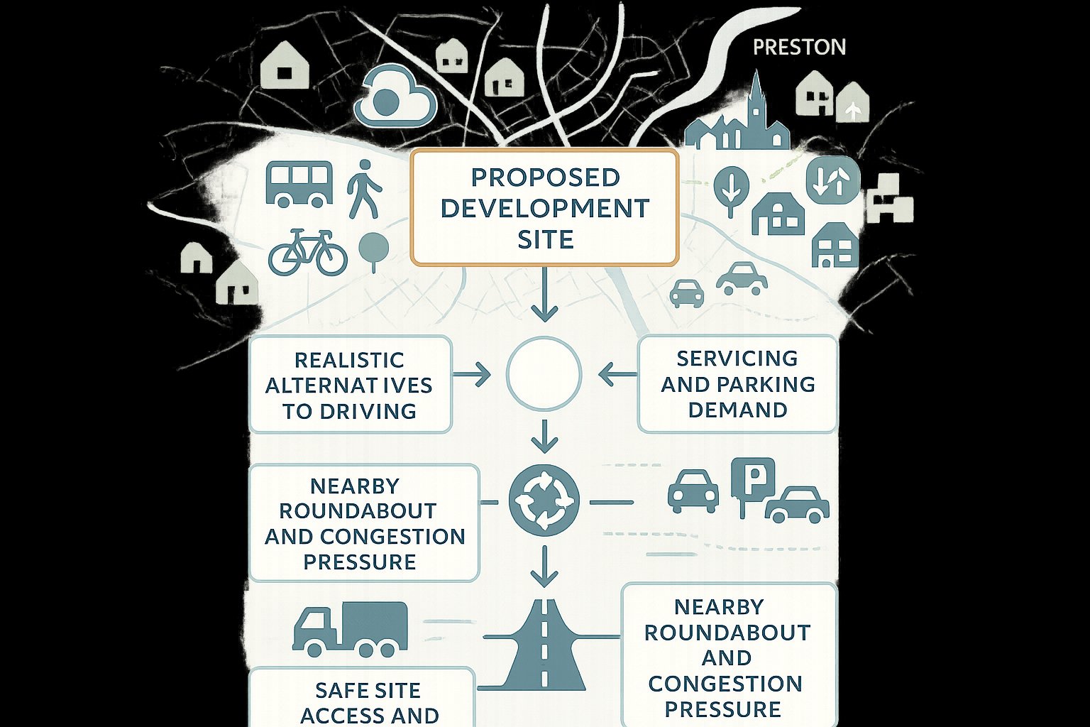
That broader role is important in Preston. Growth pressures don’t sit in a vacuum: they interact with strategic routes, local junctions and existing neighbourhoods that already experience congestion at peak times. Development can support regeneration and housing delivery, yes, but it also has to work on the ground. Councils and consultees will want to know what happens at the nearby roundabout, whether the access geometry is safe, how many car trips are likely to be generated, and whether future users have realistic alternatives to driving.
Transport planning in Preston also ties directly into policy goals beyond traffic flow. Air quality, carbon reduction, active travel and town-centre vitality all shape how schemes are assessed. A proposal in a sustainable location with credible walking, cycling and bus links will usually start from a stronger position than one that relies almost entirely on the private car.
From our side, good transport planning isn’t about producing a thick report for the sake of it. It’s about reducing uncertainty. For developers, that means fewer avoidable objections, clearer design decisions earlier in the process, and a better chance of achieving smoother planning approvals.
The Local Planning And Highway Context Shaping Preston Applications
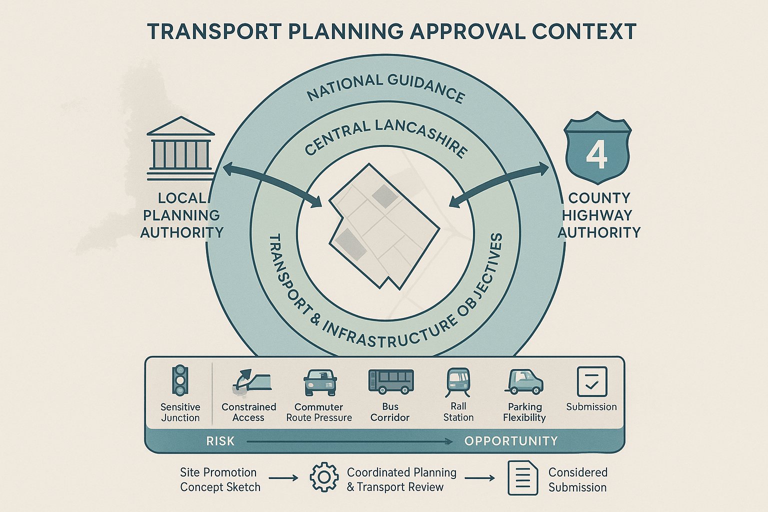
Any serious discussion of transport planning in Preston has to start with who does what. Preston City Council is the local planning authority, but Lancashire County Council is typically the local highway authority and will review the highway and transport implications of most planning applications. In practice, that means applicants need to satisfy both the planning case and the technical transport case.
The policy framework is layered. At national level, transport evidence is expected to be proportionate but robust, and developments should only be refused on highways grounds where impacts would be severe or safety issues unacceptable. Locally, that sits alongside the Central Lancashire planning framework, Preston’s development plan policies and Lancashire’s wider transport objectives. These documents work together to align land use, connectivity and infrastructure delivery.
For applicants, the key point is this: local context matters just as much as national guidance. A scheme might look modest in pure floorspace terms, yet still attract scrutiny if it sits near a sensitive junction, affects a constrained access, or adds pressure to a route already carrying commuter traffic. Equally, a town-centre or corridor location with strong bus and rail accessibility may support a more flexible discussion around parking and mode share.
This is where early review pays off. We generally advise teams to assess the planning and highway context at the same time as site promotion or concept design, not after a layout has hardened. At mltraffic.co.uk, our approach is to tailor transport reports to local authority thresholds and local decision-making realities, because generic submissions rarely perform well when consultees want place-specific evidence.
Key Development Types That Commonly Trigger Transport Evidence
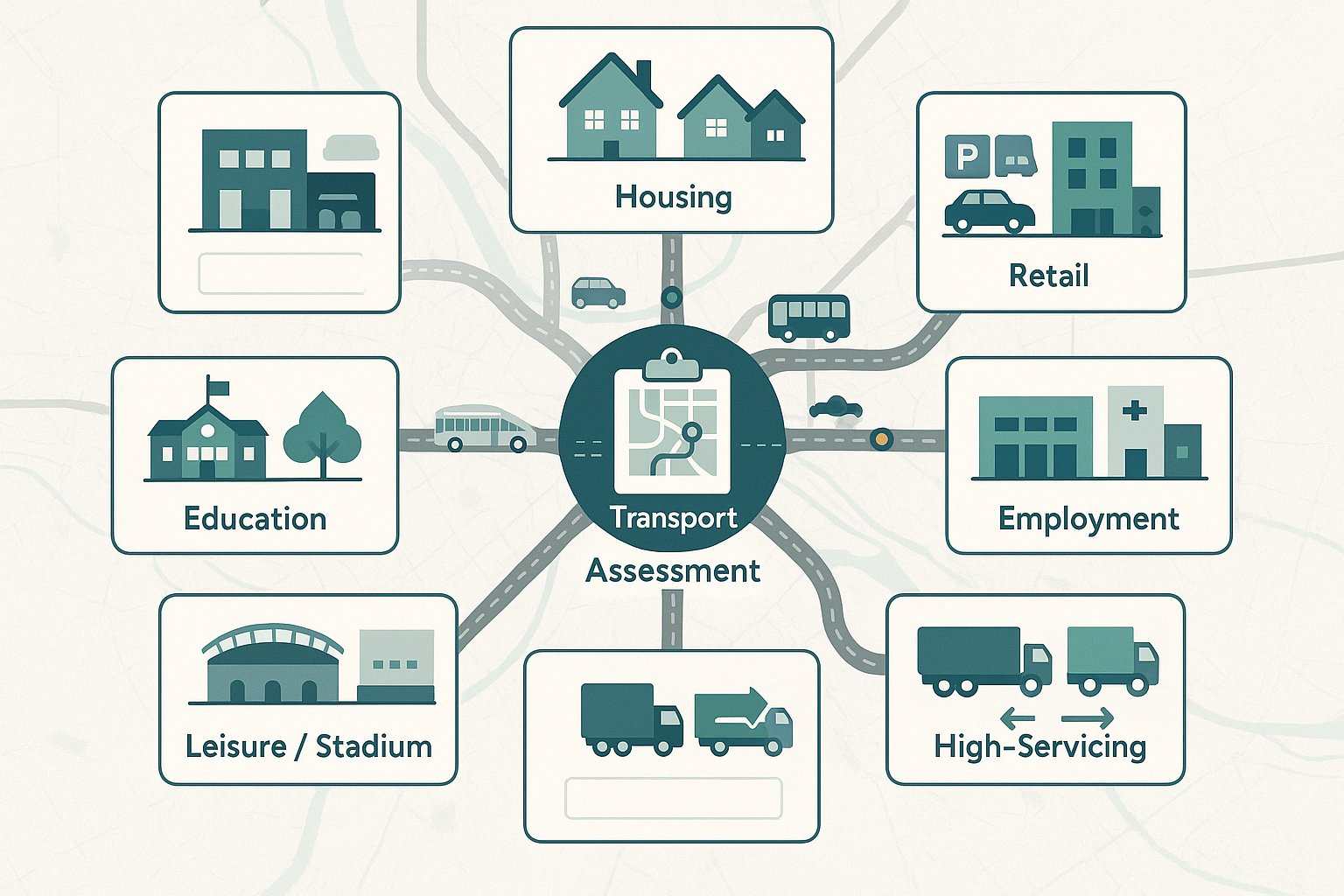
Not every scheme in Preston needs a full transport evidence package, but many more require some form of transport input than applicants first assume. The trigger is not only development size: it’s also the type of use, likely trip generation, site constraints and surrounding network sensitivity.
Major housing schemes are an obvious example. Once residential development reaches the sort of scale that materially affects local junctions or creates a substantial number of peak-hour trips, a detailed assessment is usually expected. The same applies to retail development, where arrival patterns can be concentrated and parking demand becomes a live issue, and to employment schemes such as industrial parks, warehouses and business space, particularly where staff travel overlaps with peak periods or HGV movements are significant.
Education, healthcare, stadium and leisure uses also attract close review because their travel patterns can be intense, irregular or highly site-specific. A school may create sharp morning and afternoon peaks. A health facility may raise questions around patient access, drop-off, taxis and servicing. A leisure scheme can generate evening and weekend demand when nearby roads are already under pressure for other reasons.
Then there are developments with unusually high servicing requirements. Even a scheme that doesn’t look major on paper can trigger detailed analysis if refuse vehicles, delivery lorries or articulated HGVs need to enter, turn and exit safely.
In short, transport evidence is commonly required wherever a proposal has the potential to change movement patterns in a noticeable way. The smartest approach is to identify that early, rather than hoping the issue won’t come up at validation or consultation stage.
Transport Assessments, Transport Statements And Travel Plans Explained
The terminology can sound deceptively simple. In practice, choosing the right document is one of the most important early decisions in transport planning in Preston, because submitting too little creates challenge, while submitting the wrong thing can waste time and budget.
A Transport Assessment (TA) is the most detailed of the three. It typically includes baseline transport conditions, trip generation, distribution and assignment, junction impact testing, access appraisal, parking and servicing review, road safety considerations, and mitigation proposals. It is evidence-heavy and usually quantitative.
A Transport Statement (TS) is lighter-touch. It still examines access and transport implications, but in a more proportionate way for schemes where impacts are likely to be lower. It may not require the same level of modelling or network analysis as a full TA.
A Travel Plan (TP) is different again. Rather than focusing primarily on impact prediction, it sets out how travel behaviour will be managed and improved. That might include walking and cycling measures, bus information, incentives, monitoring and targets for reducing single-occupancy car trips.
The three are not interchangeable, and they are often combined. A larger scheme may need a TA plus a Travel Plan. A smaller change of use may only need a TS, perhaps with a simple travel strategy. What matters is proportionality backed by judgement.
When A Full Transport Assessment Is Usually Needed
A full TA is usually expected for major development, but scale alone doesn’t decide it. In broad terms, residential schemes above around 80 to 100 dwellings, larger retail proposals, substantial employment floorspace or schemes with clearly material network effects will often justify a full assessment. That’s especially true where a development could affect sensitive junctions, congested corridors or links to the strategic road network.
In Preston, a full TA is commonly needed where there are existing pressure points on routes such as the A6, A59 or A582, or where a proposal may influence motorway-related movements connected to the M6 or M55. If the site has a constrained access arrangement, unusual servicing demand, or potential safety concerns for pedestrians and cyclists, that can also push a scheme into TA territory.
A proper TA should do more than present traffic numbers. It should explain the development story logically: existing conditions, future baseline, predicted trips, operational effect, and what mitigation is required, if any. Weak TAs often fail because they skip one of those steps or rely on assumptions that haven’t been agreed in advance.
When A Transport Statement Or Travel Plan May Be More Appropriate
A TS is often suitable for smaller developments, modest changes of use, or schemes where trip generation is limited and transport effects are material but not extensive. Think infill housing, smaller commercial units, redevelopments using an existing access, or town-centre proposals in accessible locations where car dependency is lower.
That said, “smaller” doesn’t mean “casual.” A good Transport Statement still needs reliable baseline information, sensible trip assumptions and a clear explanation of access, parking, servicing and sustainable travel opportunities. If those basics are missing, consultees may simply ask for more.
A Travel Plan becomes particularly relevant where the authority wants confidence that sustainable travel will be actively supported rather than vaguely referenced. Residential, school, office, healthcare and mixed-use schemes often benefit from one. The strongest plans are practical: they identify real walking routes, local bus services, cycle parking, welcome packs, monitoring arrangements and named responsibilities. The weakest ones read like copy-and-paste promises no one expects to carry out.
As a rule, if the likely impact is limited but travel behaviour still matters, a TS and/or TP may be the right proportionate response.
Core Issues Assessed In A Preston Transport Planning Review
A transport review in Preston will usually focus on a familiar set of questions, but the detail matters enormously. Authorities and consultees are rarely looking for textbook theory: they want confidence that the proposal works in this exact place, on this exact network, with this exact mix of users.
Access, Junction Capacity, Parking, Servicing And Road Safety
First comes access. Is the proposed point of entry and exit safe, visible and suitable for the expected vehicles? Can emergency, refuse and delivery vehicles manoeuvre properly? Will pedestrians cross near the access in a way that creates conflict? These are basic questions, yet they’re often where schemes start to unravel.
Then there’s junction capacity. If a development adds trips to nearby priority junctions, roundabouts or signalised nodes, the likely operational effect may need to be tested. In Preston, that can be especially relevant where local traffic already interacts with strategic movements, school traffic or commuter peaks.
Parking is another frequent flashpoint. Under-provision can create overspill stress on nearby streets: over-provision can undermine sustainable travel objectives and weaken the planning case in accessible locations. The same balancing exercise applies to servicing, particularly for commercial and mixed-use schemes where vehicle sweep paths and loading arrangements need to function without blocking circulation.
And road safety can’t be treated as an afterthought. Collision history, visibility splays, internal layout risks and the experience of vulnerable road users all feed into whether a proposal is seen as acceptable.
Walking, Cycling, Public Transport And Sustainable Travel Expectations
Transport planning in Preston isn’t only about whether cars can get in and out. Authorities also want to know whether people can reach the site without driving, and whether the development makes that realistic rather than theoretical.
That means reviewing walking connections to nearby services, schools, bus stops and local centres. Footway continuity, crossing opportunities, gradients, lighting and natural surveillance can all affect whether a route is genuinely usable. Cycling matters too, especially where sites can connect into local routes or wider assets such as the Guild Wheel, which remains one of Preston’s better-known active travel features.
Public transport is another key test. How close are the nearest bus stops? What service frequency exists at the times people actually travel? Is Preston railway station a realistic option for some users, or too remote to influence mode choice in practice? These questions shape both impact assessment and mitigation.
Sustainable travel expectations have become sharper in recent years. Vague claims that residents or employees will “use public transport where possible” don’t carry much weight. What helps is specificity: secure cycle parking, pedestrian links, travel information, welcome packs, bus ticket initiatives, EV infrastructure where relevant, and site design that doesn’t force every short trip to start with a car journey.
How Site Location In Preston Can Influence Planning Outcomes
Two developments of similar size can receive very different transport responses simply because they sit in different parts of Preston. Location shapes trip patterns, accessibility, mitigation options and, frankly, the credibility of the planning argument.
Sites near the town centre, established bus corridors, local centres or Preston railway station often benefit from a stronger sustainable transport narrative. If future residents, staff or visitors can reasonably walk to services, catch frequent buses, or cycle via attractive routes, that can reduce reliance on the private car and support a more policy-aligned case. It may also influence discussions around parking restraint, Travel Plan measures and trip generation assumptions.
By contrast, peripheral or semi-rural locations can face tougher scrutiny, especially where footways are fragmented, bus services are limited or nearby roads already feel dominated by higher-speed traffic. In those cases, applicants may need to work harder to demonstrate safe access, realistic pedestrian links and mitigation that goes beyond standard wording.
Location also affects the nature of local objection. In established residential areas, concerns may centre on rat-running, overspill parking or school-run congestion. On edge-of-network sites, the focus may be on strategic capacity, route choice or HGV impact.
We often advise clients not to treat location as a backdrop. It is part of the transport case itself. A site that is technically developable may still present a difficult planning journey if its transport geography works against the proposal and there is little realistic scope to improve it.
Common Reasons Transport Submissions Are Delayed Or Challenged
Most delayed transport submissions are not sunk by one dramatic flaw. They’re weakened by a cluster of smaller issues that signal a lack of rigour. And once that confidence is lost, requests for clarification tend to multiply.
One common problem is incomplete baseline data. Traffic counts may be out of date, collected at the wrong locations, or missing seasonal context. Another is poor trip generation logic, for example, selecting TRICS sites that don’t reflect the actual land use, location type or scale of the proposal. If the trip rates look engineered to minimise impact, reviewers will notice.
Applicants also run into trouble by ignoring committed development and background growth. A junction may appear acceptable in isolation, but not once nearby permissions are factored in. Similarly, some reports focus heavily on vehicle movements while giving only token coverage to walking, cycling, buses, parking stress or road safety.
Lack of early engagement with Lancashire County Council is another recurring issue. If scope, assessment years or modelling assumptions haven’t been discussed in advance, technical debates can erupt late in the process, when redesign is expensive.
And then there’s presentation. Even a technically competent report can be challenged if drawings are inconsistent, figures are unclear, or the conclusions overreach the evidence. Transport planning in Preston is partly about analysis and partly about trust. A concise, well-structured submission that answers the right questions will usually travel further than a bulky report that leaves readers hunting for the basics.
How To Prepare A Stronger Transport Submission For A Planning Application
A stronger submission starts well before the application is uploaded. The best results usually come when transport planning is integrated into site appraisal, layout design and planning strategy from the outset, not bolted on at the end.
First, engage early. Where appropriate, discuss scope with the local planning authority and Lancashire County Council so there is a shared understanding of whether a TA, TS or Travel Plan is needed, which junctions should be reviewed and what survey work is expected. That early alignment can save weeks later.
Second, use current and defensible evidence. That means up-to-date traffic counts, well-chosen TRICS data, realistic modal assumptions and robust modelling where required. If there are local constraints, acknowledge them rather than trying to talk past them. A candid report with sensible mitigation is often more persuasive than an optimistic one that appears selective.
Third, make sure the submission covers the practical essentials: safe access design, visibility, swept paths, parking provision, cycle parking, servicing strategy, refuse collection, pedestrian links and any road safety issues. These details are sometimes treated as appendices-only material, but they often shape the consultation response.
Fourth, be specific about sustainable travel measures. Name the bus stops. Show the walking routes. Explain cycle storage. Set out who implements the Travel Plan and how monitoring works.
This is exactly where specialist support can help. At ML Traffic, we focus on concise, accurate transport engineering reports shaped around local thresholds and planning contexts, which is often what decision-makers actually need: not more pages, just better evidence.
Conclusion
If there’s one takeaway, it’s this: transport planning in Preston is rarely a box-ticking exercise. It is a core part of the planning case, and in many applications it has an outsized influence on timing, design changes and final determination.
For developers and their consultant teams, the winning formula is usually straightforward, even if the work isn’t: understand the local policy and highway context, scope the right level of assessment early, use sound data, and address access, safety, parking, servicing and sustainable travel with real precision. Do that, and objections become easier to answer, sometimes easier to avoid altogether.
Preston will continue to grow, and that growth will keep testing the balance between movement, place quality and infrastructure capacity. The schemes most likely to secure smoother approvals in 2026 will be the ones that treat transport as part of the development strategy from day one, not as a technical afterthought once the plans are already fixed.
Transport Planning in Preston: Frequently Asked Questions
Why is transport planning important for development projects in Preston?
Transport planning supports housing and employment growth while managing congestion on key routes like the M6 and A6. It also underpins local objectives such as air quality, carbon reduction, and town-centre regeneration, ensuring developments operate safely and sustainably within Preston’s transport network.
When is a full Transport Assessment required for a Preston planning application?
A full Transport Assessment is typically needed for major developments exceeding national thresholds, such as over 80–100 dwellings, significant retail or employment floorspace, or proposals affecting sensitive junctions, congested corridors, or strategic roads like the M6 or M55 around Preston.
What roles do Preston City Council and Lancashire County Council play in transport planning?
Preston City Council acts as the local planning authority, setting policies through local and Central Lancashire plans. Lancashire County Council is the local highway authority, responsible for reviewing highway and transport impacts of planning applications to ensure safety and network efficiency.
How can developers prepare stronger transport submissions for planning approval in Preston?
Developers should engage early with Lancashire County Council to agree on scope and methodology, use up-to-date traffic data and robust modelling, and ensure submissions cover safe access, parking, servicing, and specific sustainable travel measures like walking and cycling links.
What types of developments in Preston typically require transport evidence?
Transport submissions are commonly required for major housing schemes, retail parks, industrial or business parks, education and healthcare facilities, stadiums, leisure uses, and developments with significant heavy goods vehicle or servicing traffic due to their notable impact on movement patterns.
How does site location affect transport planning outcomes in Preston?
Sites near Preston’s town centre or along strong bus, rail, and cycle corridors usually benefit from favourable sustainable transport assessments. Conversely, peripheral or rural sites with limited public transport and fragmented pedestrian links face greater scrutiny and must demonstrate realistic access and mitigation.