Chelmsford is not a place where transport can be treated as a late-stage planning add-on. For many schemes, it is one of the first things that determines whether an application moves smoothly through validation and consultation, or gets bogged down in requests for more information, revised drawings, and extra modelling. That is especially true in 2026, with continued pressure from housing delivery, employment growth, city centre intensification, and strategic infrastructure ambitions tied to the Chelmsford Local Plan and the Future Transport Network strategy.
In practice, transport planning in Chelmsford sits at the junction of policy, engineering, and planning judgement. Essex County Council, as highway authority, will want to see that access is safe, traffic effects are understood, sustainable travel has been properly considered, and any mitigation is realistic. Chelmsford City Council will also expect transport evidence to align with the wider growth strategy rather than simply showing vehicles can enter and leave a site.
We see this regularly when supporting architects, planners, developers, and legal teams: the strongest submissions are not always the biggest reports, but the ones scoped correctly from the start, grounded in local policy, and written in a way that answers the authority’s real concerns. In this guide, we set out what developers need to know about transport planning in Chelmsford, when a Transport Assessment or Travel Plan is likely to be required, what a good report includes, and how to avoid the delays that commonly hold schemes back.
Why Transport Planning Matters For Development In Chelmsford
Chelmsford’s planning landscape is shaped by growth, but growth on its own is never enough. A scheme also has to show that the surrounding network can cope, that people can reach it safely, and that it supports the area’s wider transport objectives. That is why transport planning matters so much here.
The policy backdrop is clear. Nationally, the National Planning Policy Framework asks whether a development’s residual cumulative impacts on the road network would be severe. Locally, the Chelmsford Local Plan, Essex transport policy, and the Chelmsford Future Transport Network strategy all push in the same direction: accommodate growth while reducing unnecessary car dependence and improving conditions for walking, cycling, bus, and rail use.
For developers, that has practical consequences. A residential site on the edge of the city cannot rely solely on a simple vehicular access drawing. A retail or employment proposal cannot just count parking spaces and move on. The planning authority and highway authority will want evidence on trip generation, routing, junction performance, pedestrian links, bus accessibility, cycle parking, servicing, and safety.
And there is a wider point. Good transport planning is not only defensive. Done well, it helps unlock sites. It can shape a layout before it hardens into a problem, support sensible mitigation discussions, and reduce the risk of late objections. At ML Traffic, that is often where we add the most value: producing concise, accurate reports that are tailored to local thresholds and the planning realities of Chelmsford rather than relying on generic boilerplate.
How Chelmsford’s Growth, Road Network, And Travel Patterns Shape Planning Decisions
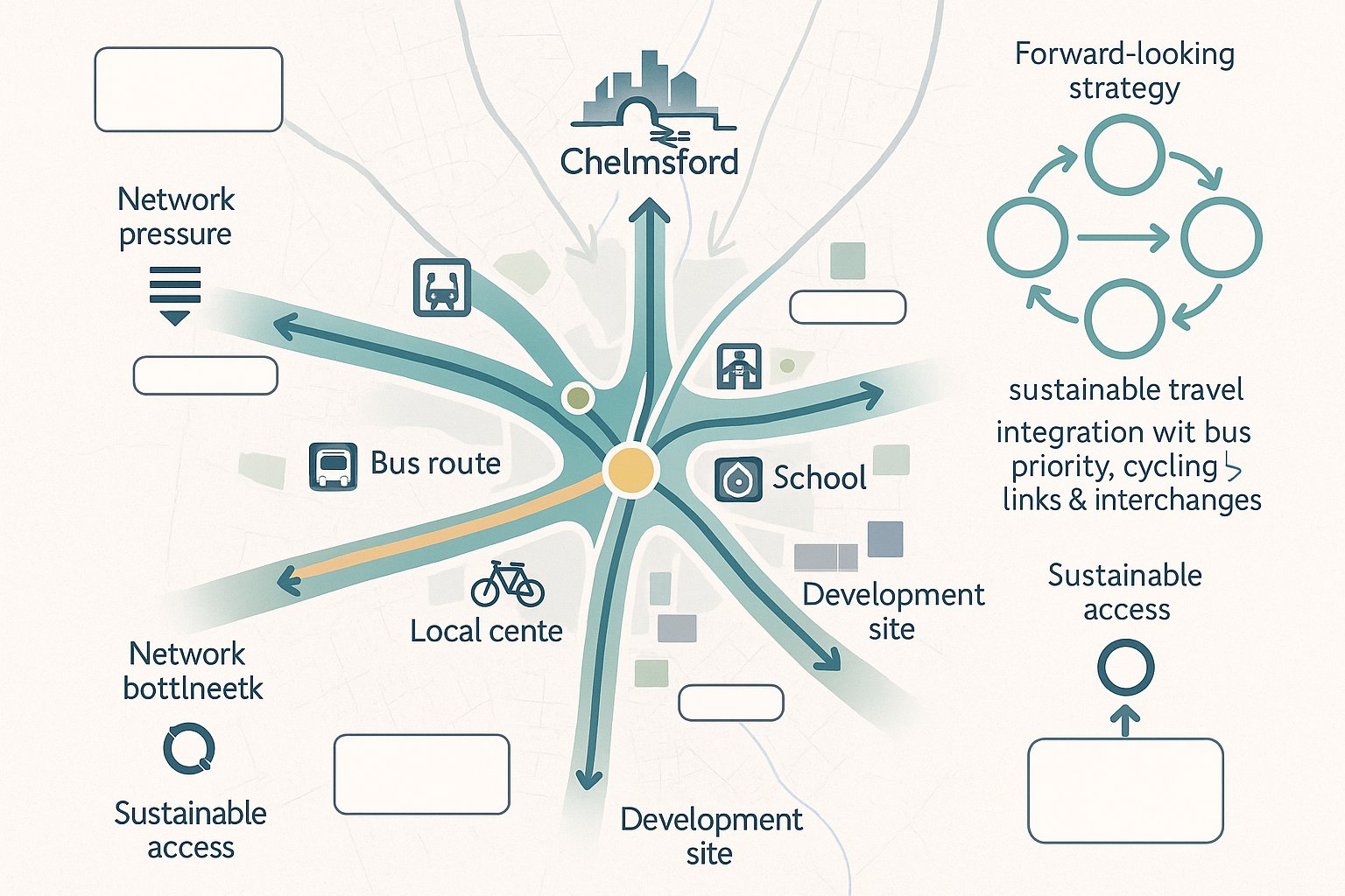
Transport planning in Chelmsford is heavily influenced by how the city actually functions day to day. It is a strong commuter location with important rail connections to London, but it also experiences familiar radial congestion on key approaches and around major junctions. Anyone preparing a planning application needs to understand that local decision-making is tied to these real movement patterns, not just site-specific access geometry.
The Future Transport Network strategy to 2036 is particularly important because it looks beyond isolated developments and considers how the city’s transport corridors and zones should evolve. In simple terms, it is not just asking whether one junction works today. It is asking how new development fits into a broader pattern of movement and whether it helps or hinders the shift to more sustainable travel.
That affects schemes on corridors influenced by roads such as the A1060, A1114, A130 and other busy city approaches. It also affects developments near rail stations, bus corridors, schools, and local centres, where the opportunity for modal shift may be stronger and hence more heavily scrutinised. New communities and strategic sites are expected to connect into interchanges, bus priority measures, and cycle routes rather than defaulting to private car dependency.
So when we prepare evidence for Chelmsford, we do not treat traffic forecasting as a standalone exercise. We tie it back to local growth areas, network pressure points, committed development, and sustainable access opportunities. That gives the report more credibility and usually makes planning discussions more productive.
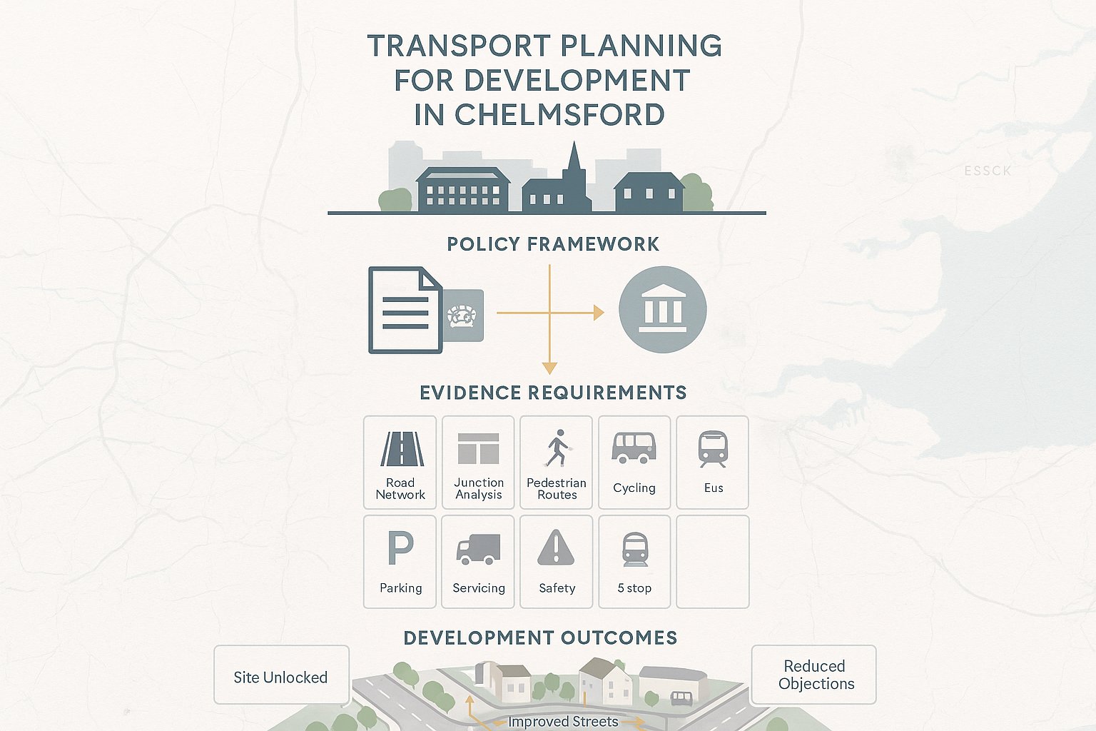
When A Transport Assessment, Transport Statement, Or Travel Plan Is Needed
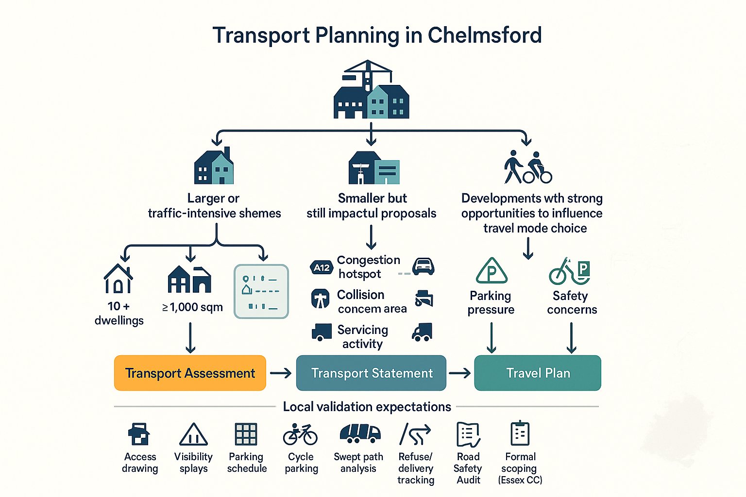
One of the most common early questions is simple: what level of transport document is actually required? In Chelmsford, the answer depends on the scale, type, and location of the development, along with its likely transport impact.
A Transport Assessment is generally needed for larger or more traffic-intensive schemes where the effect on the local network could be material. That often includes major housing, substantial employment proposals, retail development, education uses, and mixed-use schemes that generate notable person trips or servicing activity.
A Transport Statement is usually more proportionate for smaller developments where transport effects are present but not expected to be significant. It still needs to be robust. “Smaller” does not mean “light-touch” if the site sits on a constrained road, near a sensitive junction, or in an area with parking and safety concerns.
A Travel Plan is commonly required where a development will generate meaningful numbers of person trips and where there is a realistic opportunity to influence mode choice. Residential, office, education, healthcare, and strategic mixed-use development frequently fall into this category. In Chelmsford, that means setting out practical measures, targets, and monitoring arrangements rather than treating the Travel Plan as a token appendix.
Thresholds are shaped by Department for Transport guidance, local validation requirements, and Essex County Council expectations. We always advise checking the current position at the start of a project because local validation lists and authority preferences do change, and a missed requirement can slow validation immediately.
Key Planning Triggers And Local Validation Expectations
Some triggers come up again and again. Major applications, including 10 or more dwellings or 1,000 square metres or more of non-residential floorspace, are the obvious starting point. But that is not the whole picture.
Transport documents are also likely to be needed where a proposal affects A-roads, key junctions, city centre streets, or locations with known congestion or collision concerns. Schools, foodstores, drive-thrus, logistics uses, leisure schemes, and healthcare facilities can attract scrutiny because of their travel demand profile, peak hour effects, and servicing needs.
Local validation in Chelmsford will often expect more than the headline report. Depending on the scheme, supporting material may include access drawings, visibility splays, parking schedules, cycle parking details, swept path analysis, delivery and refuse tracking, and road safety audit information. For larger or more contentious applications, formal scoping with Essex County Council can be the difference between a streamlined review and a long list of follow-up questions.
The key lesson is this: do not guess. A narrowly scoped report that omits the wrong junction, ignores active travel links, or skips Travel Plan detail can create more delay than producing the right package at the outset.
What A Chelmsford Transport Planning Report Typically Includes
A good transport report for Chelmsford should read like a structured piece of planning evidence, not a bundle of disconnected technical outputs. The strongest reports move logically from policy context to baseline conditions, forecast impacts, and mitigation.
Typically, we would expect to see a review of the relevant planning and transport policy framework, including the NPPF, local transport policy, the Chelmsford Local Plan, parking standards, and the Future Transport Network strategy. Then comes the baseline: the site context, surrounding road hierarchy, walking and cycling links, nearby bus and rail services, local amenities, parking controls, and where relevant, personal injury collision history.
From there, the report should explain the proposed development in transport terms. That includes access arrangements, expected demand, parking provision, servicing, and refuse strategy. Forecasting needs to be transparent and proportionate, with assumptions that can be followed and tested by the authority.
A Chelmsford-focused report also needs to show that sustainable travel has been properly considered. That means more than a list of bus stops. It means looking at permeability, quality of pedestrian connections, cycle infrastructure, likely travel behaviour, and whether the design gives people realistic alternatives to driving.
Where mitigation is needed, it should be specific. Vague references to “encouraging sustainable travel” rarely carry weight. Authorities want to know what is being delivered, when, by whom, and how it will be secured.
Trip Generation, Distribution, And Junction Capacity Analysis
This is often the technical core of the submission. Trip generation is usually informed by TRICS, but local judgement matters. Selecting inappropriate sites, using weak filters, or ignoring local land-use context is one of the easiest ways to undermine an otherwise decent assessment.
Once trip rates are established, the next step is distribution and assignment. In Chelmsford, that should reflect real network conditions and the attractiveness of routes to the strategic road network, city centre, rail stations, and nearby settlements. Census data, observed turning counts, and local traffic patterns often help justify the agreed routing assumptions.
Junction capacity analysis may then be required on an agreed set of priority junctions, roundabouts, or signals. Depending on the layout, this can involve PICADY, ARCADY, or LINSIG modelling. The important thing is not the software itself: it is whether the modelling has been scoped properly, uses suitable baseline flows, reflects committed development where necessary, and presents results clearly.
Authorities are rarely persuaded by unexplained tables. We find it far more effective to combine the numbers with a concise narrative: where the network is stressed, what the development adds, whether the impact is material, and what mitigation, if any, is necessary to keep conditions acceptable.
Parking, Servicing, And Highway Safety Considerations
Parking can derail an application surprisingly quickly, especially in urban locations or schemes with constrained layouts. Chelmsford proposals should be checked against relevant Essex and local standards for car parking, cycle parking, disabled spaces, electric vehicle provision, and where relevant, motorcycle parking. But compliance alone is not always enough. The authority will also look at usability, allocation, management, and likely overspill risk.
Servicing is another frequent pressure point. Can delivery vehicles enter and leave in forward gear where required? Is refuse collection workable? Will emergency access be maintained? Swept path analysis often answers these questions, but the drawings need to align with the actual design, not a theoretical version that disappears at reserved matters stage.
Highway safety should be addressed with care. A review of available collision data, typically informed by STATS19 records, can help identify existing issues on the local network. If there is a pattern, the report should engage with it honestly and explain whether the proposal would worsen conditions or whether mitigation is needed.
For schemes involving new or altered accesses, road safety audit input may also be necessary. Again, the best submissions are direct. They show safe visibility, workable geometry, clear pedestrian routes, and a realistic understanding of how the site will operate once occupied.
Common Development Types That Require Transport Input In Chelmsford
In Chelmsford, some development types almost always need transport input, even where the scale seems modest on paper.
Residential development is the obvious one. That includes larger housing sites, apartment schemes, care-led housing, and town centre redevelopment. The transport issues can range from access design and parking stress to school-run traffic, walking links, and impact on nearby junctions.
Employment uses also attract detailed review, especially industrial, warehouse, and logistics proposals. These schemes may generate fewer staff trips than some office developments, but they often raise bigger questions around HGV routing, servicing hours, yard operation, and junction impacts.
Retail and leisure uses can be particularly sensitive because demand peaks may not align neatly with standard commuter assumptions. Foodstores, drive-thrus, gyms, restaurants, and roadside formats often need careful analysis of turning movements, parking accumulation, and interaction with existing congestion.
Education, healthcare, and community facilities frequently require transport evidence too. A school or medical centre can generate concentrated person trips and short-stay parking demand in a way that puts immediate pressure on nearby streets. These uses also tend to raise strong local concern, so clear evidence matters.
Even smaller developments can trigger transport work if they sit on constrained plots, affect classified roads, or involve awkward servicing. In other words, use class alone does not decide the issue. In Chelmsford, location, access conditions, and travel characteristics are just as important as floorspace or unit count.
How Transport Planning Supports Planning Applications And Appeals
Transport planning does more than satisfy a validation checklist. It creates the technical case for why a scheme should be approved.
At application stage, a well-prepared transport submission helps officers and consultees understand the likely effects of the proposal, the credibility of the forecasts, and whether mitigation is sufficient. If done properly, it can reduce ambiguity around access, parking, servicing, active travel, and traffic impact. That matters because uncertainty often leads to holding objections rather than early support.
It also plays a central role in negotiations. Contributions and off-site works linked to section 106 or section 278 agreements usually depend on a clear evidence base. If the transport case is weak, discussions around bus stop upgrades, crossing improvements, junction works, or Travel Plan measures become harder and more expensive.
On appeal, the value of solid transport planning becomes even more obvious. Inspectors want coherent evidence that links policy, analysis, and professional judgement. A report that clearly addresses whether impacts are severe, whether sustainable travel has been prioritised, and whether mitigation is deliverable can be highly persuasive.
In Chelmsford, appeals are not decided in a vacuum. Local Plan strategy, Essex highway concerns, and the city’s longer-term transport direction all matter. That is why the most resilient evidence does not simply argue that traffic increases are “small”. It explains how the development fits within the local transport framework and why any impacts should be considered acceptable in planning terms.
Frequent Reasons Transport Reports Are Delayed Or Challenged
Most transport report delays are avoidable. They tend to stem from scope, data, policy alignment, or presentation rather than from any deep technical flaw.
One of the biggest problems is poor early scoping. If the wrong study area is chosen, the wrong peak hours are assessed, or an obviously relevant junction is left out, Essex County Council is likely to ask for revisions. That can knock weeks off a programme, sometimes more if fresh survey work is needed.
Another common issue is out-of-date or weak traffic survey data. Survey dates, school holiday effects, network disruption, or incomplete turning counts can all undermine confidence in the assessment. Authorities want representative information, not numbers that look convenient.
We also see reports challenged because they underplay sustainable travel. In Chelmsford, the Future Transport Network strategy and wider planning policy make it risky to focus almost entirely on vehicular access. If a submission ignores pedestrian permeability, cycle connectivity, bus links, or realistic Travel Plan measures, it can appear disconnected from local policy.
Then there is Travel Plan quality itself. A short generic statement with no targets, no coordinator role, no welcome packs, no monitoring period, and no review mechanism is unlikely to satisfy a highway authority for a trip-intensive scheme.
Finally, some reports simply fail on communication. Dense appendices without a clear narrative, inconsistent drawings, unexplained assumptions, and conflicting numbers between chapters all create doubt. Technical work can be perfectly competent and still run into trouble if it is not presented in a way that planners and consultees can follow.
How To Prepare A Strong Transport Submission From The Start
The strongest transport submissions usually start before the planning application is drafted. Early coordination saves time later, and in Chelmsford that is especially true where local policy and highway expectations are quite specific.
First, we recommend early pre-application engagement with both Chelmsford City Council and Essex County Council where the scale or sensitivity of the site warrants it. A short written scoping agreement on survey extents, assessment years, junctions, committed development, and document type can remove a huge amount of uncertainty.
Second, the site layout and transport strategy should be developed together. Too many schemes still treat transport as a compliance exercise after the architecture is largely fixed. But walkability, cycle permeability, bus access, bin collection, servicing, parking arrangement, and emergency access all need to work as one package.
Third, use the current policy framework and standards. That means checking the latest local validation requirements, Essex parking guidance, relevant transport policy, and the Chelmsford growth context. We should never assume that an approach accepted on a previous project will automatically be accepted on the next one.
Fourth, make the submission evidence-led but readable. Clear plans, well-labelled figures, realistic modelling assumptions, and a concise explanation of impacts go a long way. So does being candid about constraints. Authorities are generally more receptive to a report that identifies a problem and proposes a sensible solution than one that tries too hard to insist everything is negligible.
And finally, if a Travel Plan is needed, make it monitorable. Include meaningful targets, practical measures, responsibilities, and a realistic review structure. That is what turns a transport document from a paper exercise into a planning tool that can genuinely help a scheme through the system.
Conclusion
Transport planning in Chelmsford is becoming more exacting, not less. The direction of travel is clear: development must support growth, but it must also respond to congestion, safety, sustainable movement, and the city’s longer-term transport strategy to 2036.
For developers, that means the quickest route to planning approval is rarely the lightest-touch report. It is the right report, scoped properly, grounded in local policy, and backed by clear evidence on trip generation, junction performance, parking, servicing, safety, and Travel Planning.
When those pieces are dealt with early, applications tend to move more smoothly, negotiations are more focused, and appeals are easier to defend if they arise. When they are left vague or incomplete, delays are almost built in.
In our experience, successful transport planning in Chelmsford comes down to one thing: treating transport as part of the development strategy from day one, not as a technical appendix added at the end.
Frequently Asked Questions about Transport Planning in Chelmsford
Why is transport planning so important for developments in Chelmsford?
Transport planning ensures developments support Chelmsford’s growth while managing road network capacity, safety, and sustainable travel priorities. It aligns with local and national policies to prevent severe highway impacts and promote walking, cycling, bus, and rail use.
When is a Transport Assessment or Travel Plan required in Chelmsford planning applications?
A Transport Assessment is needed for larger or traffic-intensive developments like major housing or retail schemes. Smaller developments may require a Transport Statement. A Travel Plan is required where significant person-trip generation occurs, offering practical, monitored measures to encourage sustainable travel.
How do Chelmsford’s travel patterns influence transport planning decisions?
Transport planning reflects real travel patterns, including strong rail commuting and congestion on key roads like the A1060, A1114, and A130. The Future Transport Network strategy guides how new developments integrate with sustainable corridors, bus priority, cycle routes, and interchanges to reduce car dependency.
What are common reasons for delays in transport report approvals in Chelmsford?
Delays often arise from poor scoping, outdated traffic data, ignoring sustainable travel policies, insufficient Travel Plan detail, or unclear report communication. Early engagement with authorities and alignment with local policy can prevent these issues and speed up validation.
How should developers prepare a strong transport planning submission in Chelmsford?
Start with early pre-application discussions with local councils to agree scope and surveys. Integrate transport strategy with site layout focusing on walking, cycling, and bus access. Use current Local Plan and Essex standards, provide clear evidence, and include a robust, monitorable Travel Plan.
What transport considerations are critical for residential and employment developments in Chelmsford?
Developments must demonstrate safe access, appropriate car and cycle parking, servicing arrangements, and support for sustainable travel modes. For employment sites, HGV routing and servicing hours are key, while residential schemes must address local traffic, school-run impacts, and nearby junction capacity.