A visibility splay assessment can look deceptively simple on a drawing: a pair of lines, a triangle of clear space, a few dimensions. But in planning terms, those lines often decide whether a proposed access is acceptable, whether a site layout survives highways scrutiny, and sometimes whether a development is viable at all.
We see this regularly across planning applications for housing, commercial schemes, schools, rural sites and industrial uses. An access may appear workable on paper, yet once measured speeds, gradients, bends, hedges, walls and vehicle movements are properly tested, the required visibility can be very different from what was first assumed. That is exactly why local planning authorities and highway officers treat visibility as a core safety issue rather than a drafting exercise.
In UK practice, a visibility splay assessment examines whether drivers emerging from a junction or site access can see approaching traffic far enough in advance to make a safe manoeuvre. The work sits at the intersection of transport planning, highway design, topographical survey and planning strategy. Get it right early and the application process tends to move more smoothly. Get it wrong and objections, conditions, redesigns or refusals can follow.
In this guide, we explain what a visibility splay assessment involves, when it is needed, how it is undertaken, which standards usually apply in the UK, the common reasons schemes fail, and what can be done to resolve problems before they become planning obstacles.
What A Visibility Splay Assessment Is And Why It Matters
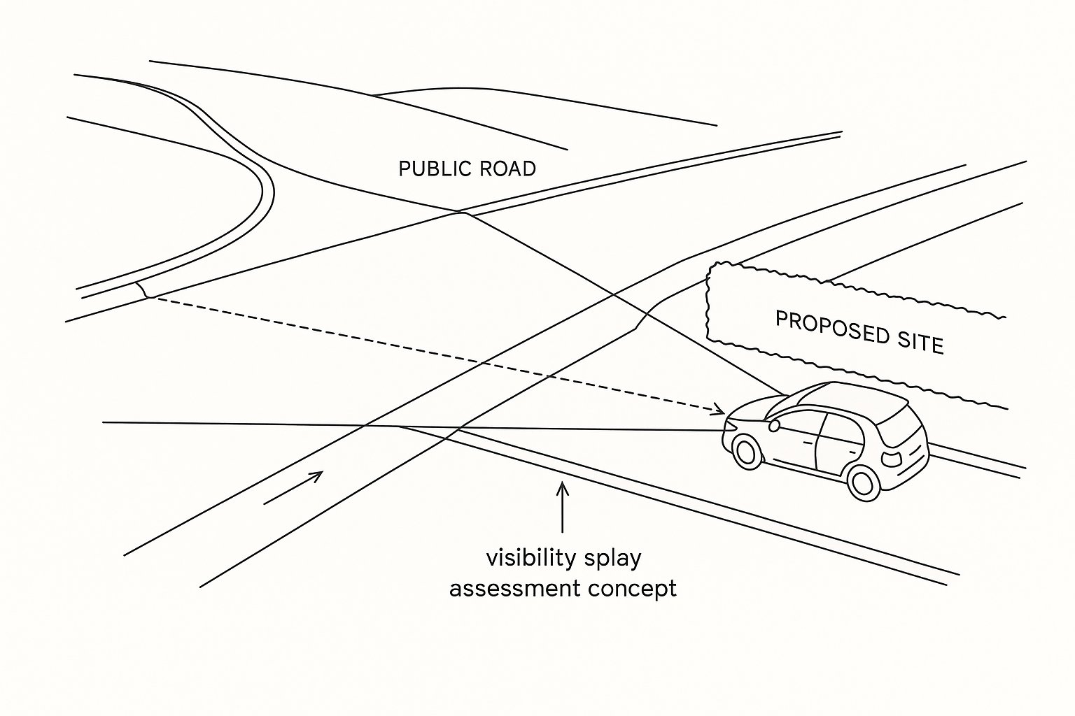
A visibility splay assessment is a technical review of the sightlines available at a proposed or existing access, junction or priority-controlled connection. In practical terms, we are checking whether a driver waiting to emerge can see oncoming vehicles on the main road at a sufficient distance to react and proceed safely.
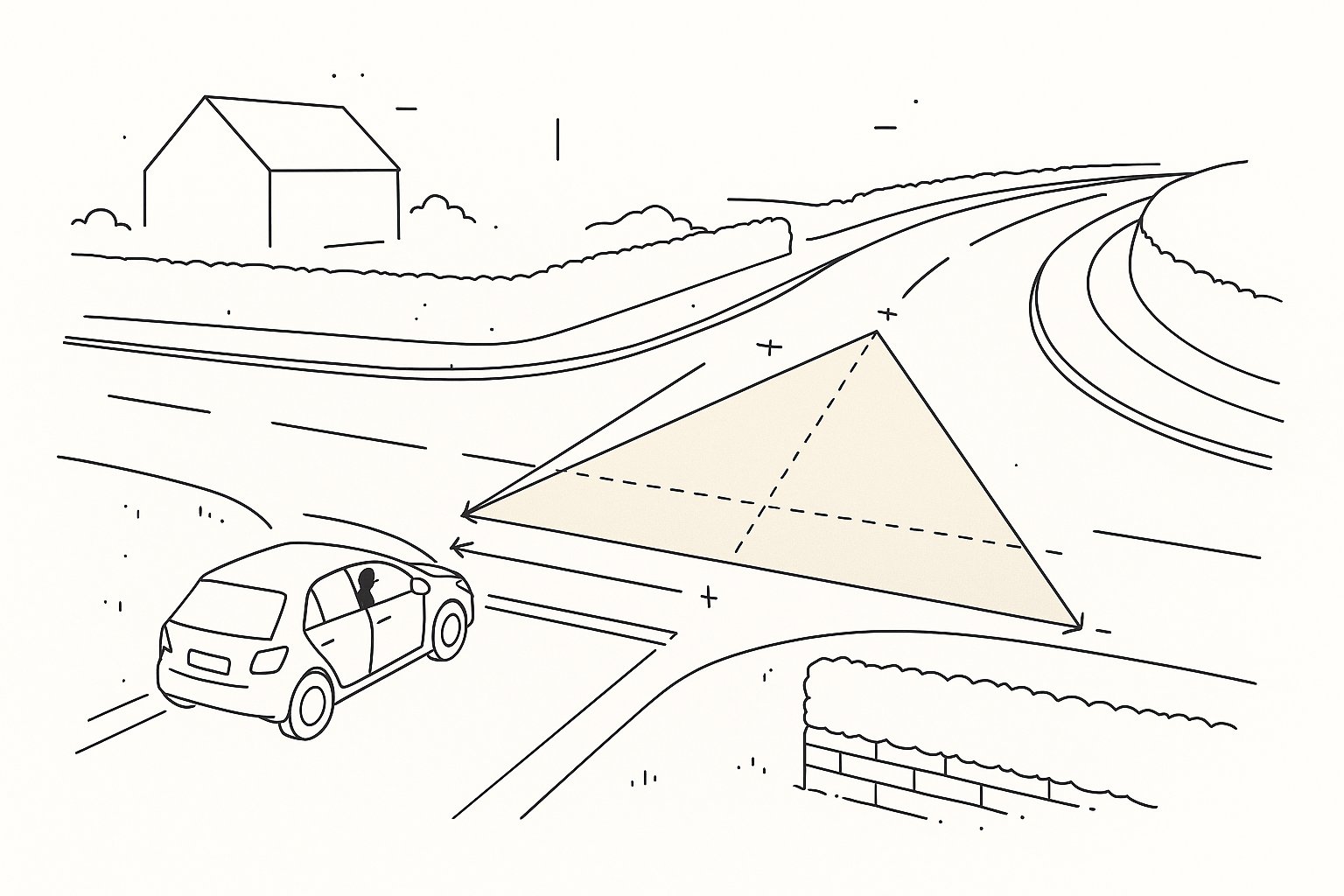
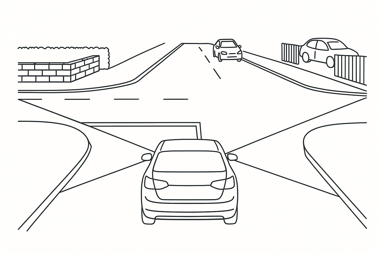
The visibility splay itself is usually represented as a clear triangular area. One point sits back from the give-way line at the driver’s eye position, and the other points extend along the edge of the major road in each direction. If walls, fences, vegetation, embankments, parked vehicles, buildings or even changes in vertical alignment interrupt that sightline, the access may not meet policy or design guidance.
Why does this matter so much? Because visibility is tied directly to stopping sight distance and collision risk. If an approaching driver cannot be seen in time, or if the emerging driver has an incomplete view of the carriageway, the junction becomes less forgiving. Highway authorities know that poor visibility can turn an otherwise modest development into a material road safety concern.
For planning applications, that means a visibility splay assessment is often more than a supporting drawing. It can influence access location, internal layout, boundary treatment, land ownership requirements and the overall prospects of consent. On constrained sites, visibility can be the issue that shapes the whole scheme.
When A Visibility Splay Assessment Is Required
A visibility splay assessment is typically required whenever development introduces a new vehicular access, intensifies the use of an existing one, or alters junction arrangements in a way that could affect highway safety. In some cases the need is obvious from the outset. In others, it emerges through pre-application discussions or transport scoping with the local highway authority.
As a rule, the more a development relies on vehicles entering or leaving the public highway, the more likely visibility will need to be demonstrated. That applies to both greenfield and infill sites, urban and rural contexts, and private accesses that connect onto adopted roads.
Planning officers and highway officers often expect visibility evidence at application stage, particularly where the site sits on a faster road, close to bends, near a crest, or behind existing front boundary features. Even where outline consent is being sought, they may still require enough information to be satisfied that a compliant access can be achieved. On other schemes, visibility is secured by condition, with detailed drawings submitted later.
Either way, treating the assessment as an afterthought is risky. If the access geometry is designed first and visibility checked later, teams can find themselves redesigning the frontage, reducing developable area or facing refusal on highways grounds.
The Core Elements Of A Visibility Splay
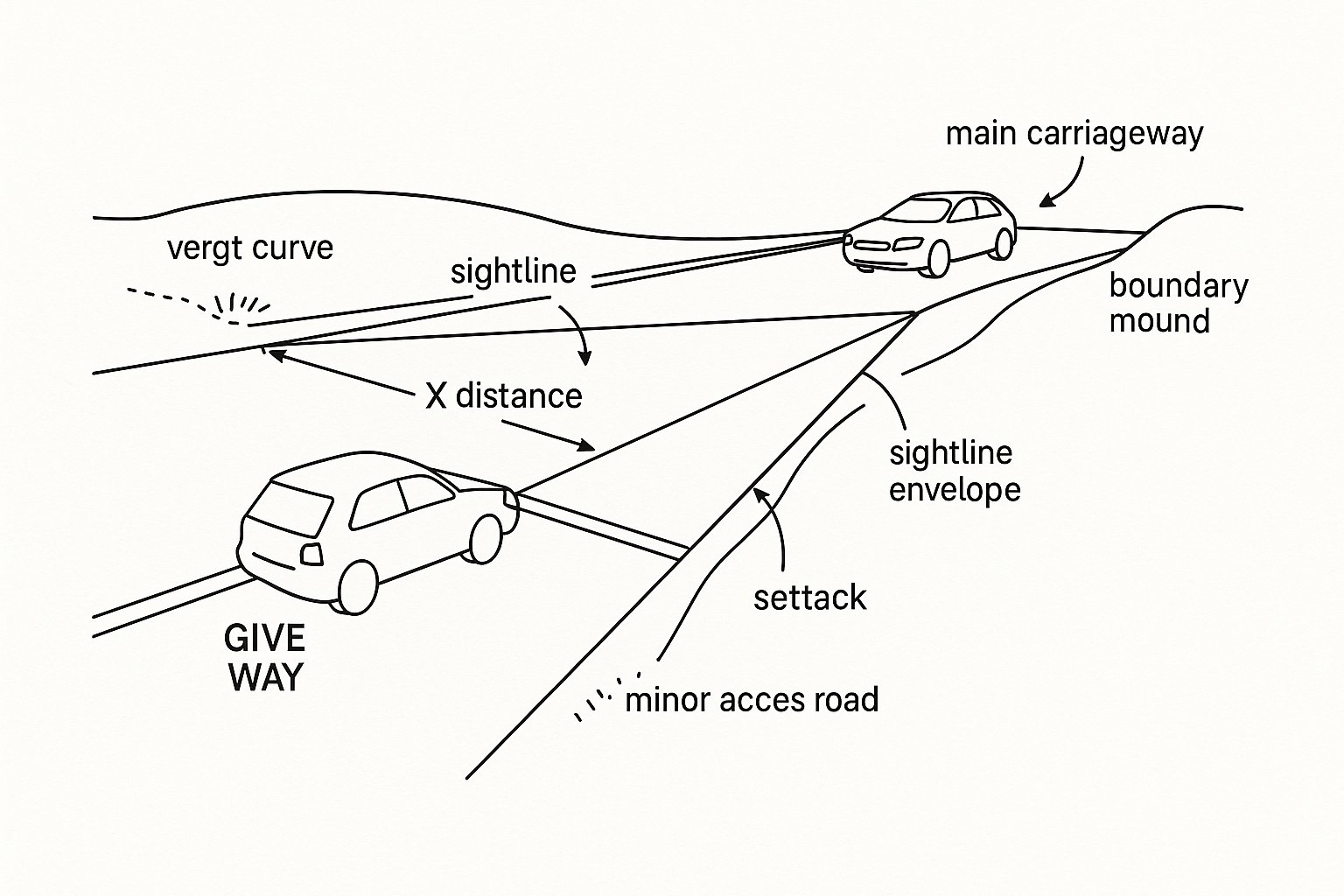
At the heart of any visibility splay assessment are a few core geometric and operational components: the X distance, the Y distance, the setback from the carriageway edge or give-way line, and the sightline envelope itself.
These are not arbitrary dimensions. They are linked to how a driver actually waits, looks, judges a gap and enters the main road, and to how quickly approaching traffic can stop under wet-road conditions. That is why the same site can produce very different requirements depending on road speed, access type and the standard being applied.
A common misconception is that visibility is only a horizontal plan issue. It is not. We also need to understand levels, gradients and the vertical relationship between the observer, target object and road profile. A clean-looking plan can still fail once crest curves, verge build-up or boundary mounding are properly modelled.
For planners, architects and developers, understanding these elements early helps avoid simplistic assumptions. A 2.4 metre setback and a standard pair of splays might work on a calm residential street, but a rural road with higher actual speeds or an industrial access serving larger vehicles may demand something quite different.
How A Visibility Splay Assessment Is Carried Out
A proper visibility splay assessment starts with evidence, not guesswork. We first establish the nature of the access or junction being tested, the road classification, the surrounding layout, and the standard most likely to govern the design. From there, we gather the data needed to test visibility in a way that will stand up to scrutiny.
That usually means obtaining a topographical survey that captures carriageway edges, kerbs, verges, footways, levels, gradients and all relevant obstructions within the required envelope. If speed is a determining factor, we also review existing speed data or commission speed surveys to establish realistic 85th percentile wet-weather approach speeds. On many sites, that speed evidence is the difference between a modest Y distance and a very demanding one.
The geometry is then plotted in CAD, with the driver’s eye position set at the relevant X distance and the required Y distances projected along the nearside edge of the main road. We test whether the sightlines remain clear within the specified eye and target height range and, where necessary, examine long-sections or 3D relationships to confirm vertical visibility.
Finally, we compare the results against the applicable national or local guidance and report whether the access is compliant, constrained or capable of improvement through design changes or mitigation.
Key Standards And Guidance Used In The UK
In the UK, visibility splay assessments are not governed by a single universal rulebook. The applicable standard depends on the road environment, the nature of the development and, crucially, the stance of the local highway authority.
For lower-speed streets and many urban contexts, Manual for Streets and Manual for Streets 2 remain central references. They set out the relationship between vehicle speed, stopping sight distance and visibility at junctions, and they are often the starting point for residential developments and local street networks.
For higher-speed roads, strategic routes and situations where a more rigorous trunk-road style approach is needed, the Design Manual for Roads and Bridges (DMRB) is often more relevant. Its stopping sight distance principles and junction visibility expectations can produce substantially larger requirements than those seen on quieter streets.
Then there are local highway design guides. Counties and unitary authorities frequently publish their own requirements on X distances, eye and object heights, frontage treatments and acceptable relaxations. These local documents matter because they are often what development management officers apply in day-to-day decisions.
We also see value in CIHT-led research and sector good practice on visibility and road safety at priority junctions, particularly when dealing with constrained existing networks or when a professional justification for a design response is needed. In short: the right standard is context-specific, and choosing it correctly is half the battle.
Typical Problems That Cause A Visibility Splay To Fail
Most failed visibility splay assessments are not the result of obscure technicalities. They usually come down to a handful of recurring issues.
The most obvious is physical obstruction. A hedge that looked harmless during a desktop review turns out to sit within the splay. A boundary wall is too high. A neighbouring building clips the sightline. A bend or crest in the carriageway shortens what drivers can actually see. Rural sites are especially prone to this, because verges, ditches, banks and vegetation create messy real-world conditions that flat plans often hide.
Speed evidence is another common weak point. If a scheme relies on assumed speeds that are lower than actual observed vehicle behaviour, the Y distance can be underestimated. Highway officers are rarely persuaded by optimistic assumptions, especially on roads that feel faster than the posted limit.
Survey quality also matters more than many teams expect. Incomplete survey extents, poor level data, missing obstruction heights, or a mis-plotted give-way line can all invalidate the exercise. We have seen cases where a few centimetres at the wrong reference point materially changed the conclusion.
And then there is geometry. If the vehicle path, waiting position or turning arrangement is unrealistic, the access may appear compliant in theory but fail in operational terms once real vehicle movements are considered.
How Visibility Splay Issues Can Be Resolved
The good news is that a failed or marginal visibility splay does not always mean a site is undeliverable. But it does mean the response needs to be technical, proportionate and, ideally, early.
The most effective solution is often to relocate the access to a straighter, flatter section of road. That sounds obvious, but on many constrained sites the first proposed access point is driven by layout convenience rather than highway performance. A modest shift in position can transform the available sightline.
Where the access must remain broadly where it is, we may be able to clear the splay by removing, lowering or setting back obstructions. Walls can be reduced, fences changed, vegetation management specified, and embankments regraded. For planning purposes, though, the key question is control: can the applicant actually deliver and maintain that land as clear visibility space?
In some locations, reducing approach speed can also help. That might involve traffic calming, gateway features or a lower speed environment, although such measures need authority support and robust justification. They cannot simply be assumed.
Other options include revising the junction form, altering the critical movement pattern, introducing one-way operation, or supporting a constrained design with additional safety evidence. The right answer depends on whether the problem is horizontal geometry, vertical alignment, driver behaviour, land ownership or all four at once.
Visibility Splay Assessments Within Planning Applications And Appeals
Within planning applications, visibility splay assessments usually sit alongside a Transport Statement, Transport Assessment, access appraisal or standalone technical note. Their role is straightforward: demonstrate that the proposed access arrangement is safe, policy-compliant and capable of implementation.
Highway authorities will typically want to see dimensioned splay drawings, the basis for any speed assumptions, details of obstruction removal where relevant, and confirmation that the land needed for the splays is within the applicant’s control or can be secured. If that information is missing, the authority may ask for further detail, impose conditions, or recommend refusal.
Conditions commonly require visibility splays to be provided before the access is first used and retained thereafter free of obstruction above a stated height, often around 1.0 metre within the relevant envelope. Those conditions sound routine, but they have real design consequences for landscaping, boundary treatments and ongoing site management.
At appeal, visibility evidence tends to receive close attention because it goes directly to highway safety. Inspectors often look at whether the chosen standard was appropriate, whether the speed data is robust, whether the drawings reflect actual site conditions, and whether any shortfall is minor, justified and mitigated. Weak evidence rarely improves with age. Clear, measured and well-reasoned assessment does.
Conclusion
A visibility splay assessment is one of those highway exercises that can seem routine until it decides the fate of a planning application. It links measured speed, stopping sight distance, site geometry and driver behaviour into a single test of whether an access can operate safely.
For architects, planners, surveyors, developers and councils, the practical lesson is simple: visibility should be tested early, with proper survey information and the right UK guidance for the road in question. Assumptions made too casually at concept stage often become expensive later.
We have found that the strongest outcomes come from combining accurate survey work, realistic speed evidence and planning-aware design advice from the outset. That is especially true on constrained or high-speed frontages where access strategy can shape the entire development.
Handled well, a visibility splay assessment does more than satisfy a highway officer. It gives the wider project team confidence that the proposed access is defensible, deliverable and less likely to unravel under planning scrutiny or at appeal.
Visibility Splay Assessment FAQs
What is a visibility splay assessment and why is it important?
A visibility splay assessment evaluates drivers’ sightlines at a junction or access, ensuring approaching traffic can be seen early enough to stop safely. It is vital for highway safety, planning approval, and determines if a new or modified access meets required safety standards.
When is a visibility splay assessment required in the UK?
It is usually needed when a development creates or intensifies vehicular access to a public highway, or alters junctions that affect road safety. This includes housing, commercial, industrial, and school developments, often requested at the planning application stage or as a condition for approval.
How are the key distances in a visibility splay defined and applied?
The assessment uses an X distance (setback from the give-way line, commonly 2.4m) representing the driver’s eye position, and Y distances along the main road in each direction based on stopping sight distance derived from the 85th percentile wet-weather speeds. These ensure safe visibility for drivers entering the road.
What are common reasons for visibility splay assessment failure?
Failures are frequently caused by physical obstructions like hedges, walls, buildings, or road bends and crests limiting sightlines. Inaccurate speed data, incomplete surveys, and unrealistic vehicle movement assumptions also contribute to non-compliance, risking planning refusal on highway safety grounds.
How can visibility splay issues be resolved if a site fails assessment?
Solutions include relocating the access to a straighter or flatter section of road, removing or reducing obstructions within the splays, introducing traffic calming to reduce approach speeds, or redesigning junction layouts. Early and technical intervention improves compliance and planning outcomes.
What UK standards guide the visibility splay assessment process?
For lower-speed urban roads, Manual for Streets and Manual for Streets 2 provide guidance, while Design Manual for Roads and Bridges (DMRB) applies to higher-speed or trunk roads. Local Highway Design Guides and CIHT research further inform specific X/Y distances and sightline requirements.