Getting transport planning Hereford right is rarely the bit that makes the glossy brochure. But it is often the bit that decides whether a scheme moves forward smoothly, gets tied up in revisions, or attracts avoidable objections from the local planning authority and highways consultees.
In Hereford, that matters more than many teams first assume. The city’s network is shaped by a historic centre, constrained river crossings, strategic routes carrying mixed traffic, and a policy context that expects development to support accessibility, safety, health, climate goals and economic growth at the same time. In practice, that means transport evidence needs to do more than tick a box. It has to show, clearly and credibly, how a proposal will work on the ground.
For architects, planners, lawyers, surveyors, developers and councils, the challenge is usually not whether transport work is needed, but what level of work is proportionate, what evidence should sit behind it, and how to avoid the familiar cycle of late data requests and design changes.
In this guide, we set out a practical view of transport planning in Hereford in 2026: when a Transport Statement, Transport Assessment or Travel Plan is likely to be needed, how local constraints influence decisions, what evidence tends to carry weight, and how to shape a planning strategy that stands up first time.
Why Transport Planning Matters For Development In Hereford
Transport planning matters in Hereford because movement is not a side issue to development: it is one of the main tests of whether growth is acceptable and deliverable.
Herefordshire Council’s wider transport approach links development with economic performance, safer travel, better accessibility, healthier streets and environmental quality. So when a planning application comes forward, the question is not simply, “Will there be more traffic?” It is also whether the scheme supports a network that people can use safely and efficiently, including those walking, cycling, using buses or travelling with reduced mobility.
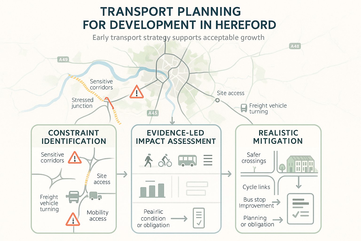
That policy context has real consequences. A site that appears modest in scale can still attract scrutiny if it sits on a sensitive corridor, adds turning movements at a stressed junction, or relies on an access arrangement that is awkward for larger vehicles. Equally, a well-planned scheme can gain traction when the transport case is proportionate, locally aware and tied closely to the design.
In our experience, strong transport planning Hereford submissions do three things early. They identify likely constraints before layouts harden. They explain impacts using evidence rather than assumption. And they set out mitigation in a way that is realistic to deliver through planning conditions or obligations.
That is why transport work should be part of project strategy from the outset, not a late-stage technical add-on.
When A Transport Statement, Transport Assessment, Or Travel Plan Is Needed
The level of transport documentation should match the scale, nature and location of the proposal. That sounds obvious, but it is where many applications drift off course.
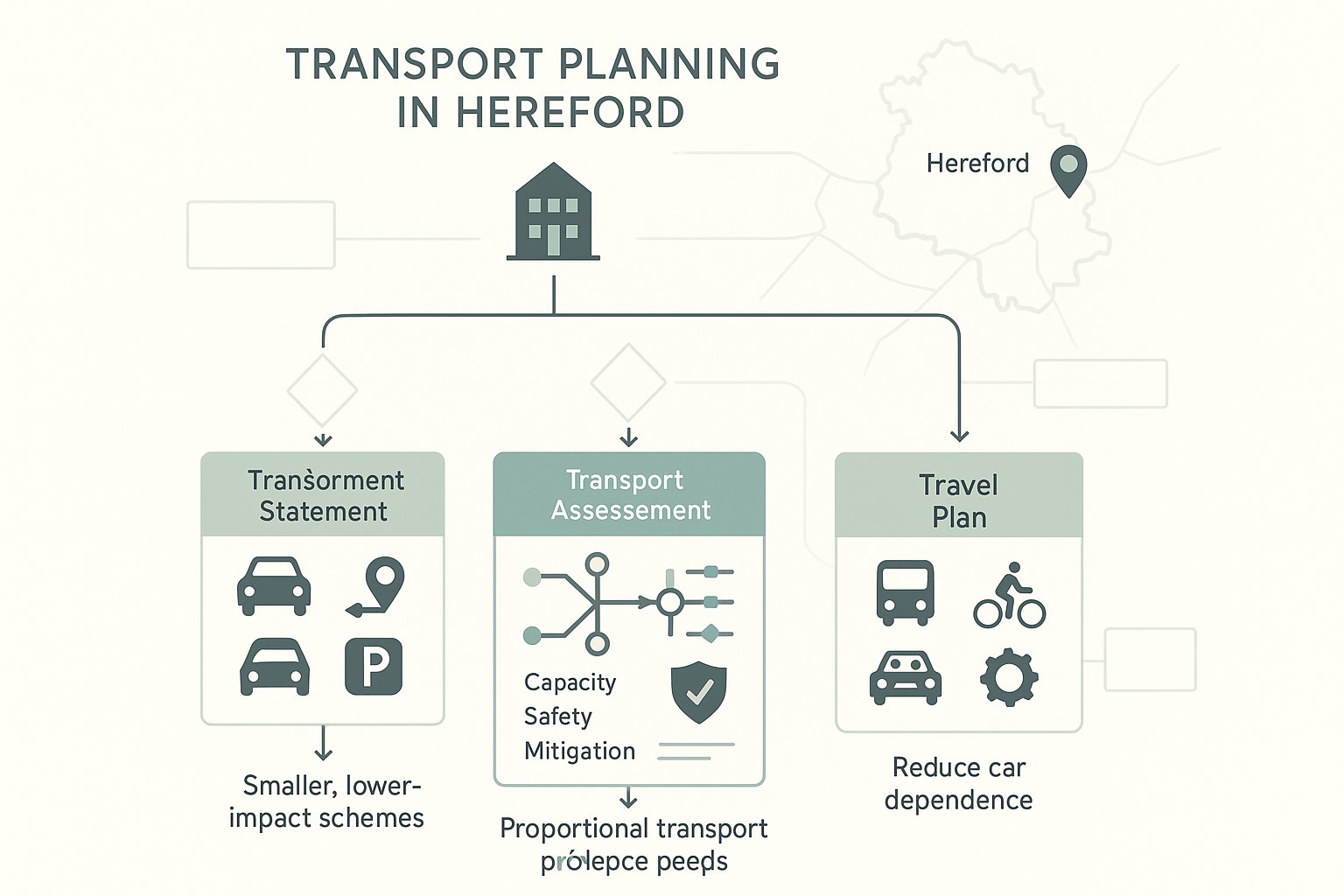
A Transport Statement is usually appropriate where impacts are limited but still need to be demonstrated properly. It typically summarises existing conditions, access arrangements, parking, sustainable travel opportunities and the likely traffic effect of the development. For smaller residential or commercial schemes, this can be enough if the local network can comfortably accommodate the change.
A Transport Assessment is generally needed where the proposal is larger, more complex, or likely to materially affect capacity, operation or safety. That often means fuller trip generation analysis, junction modelling, committed development review, mitigation testing and a broader appraisal of mode choice.
A Travel Plan may accompany either document where there is a need to show how car dependency will be reduced and sustainable travel encouraged. On employment, education, healthcare and mixed-use sites in particular, this can be a significant part of the package rather than an afterthought.
The key point is proportionality. National and local policy do not usually demand the same depth of evidence for every site. But they do expect the submitted evidence to be robust enough for decision-makers to understand likely transport effects.
Where thresholds are unclear, early scoping with the council and highways advisers is often the smartest move. It can save weeks later.
How Hereford’s Local Network Shapes Planning Decisions
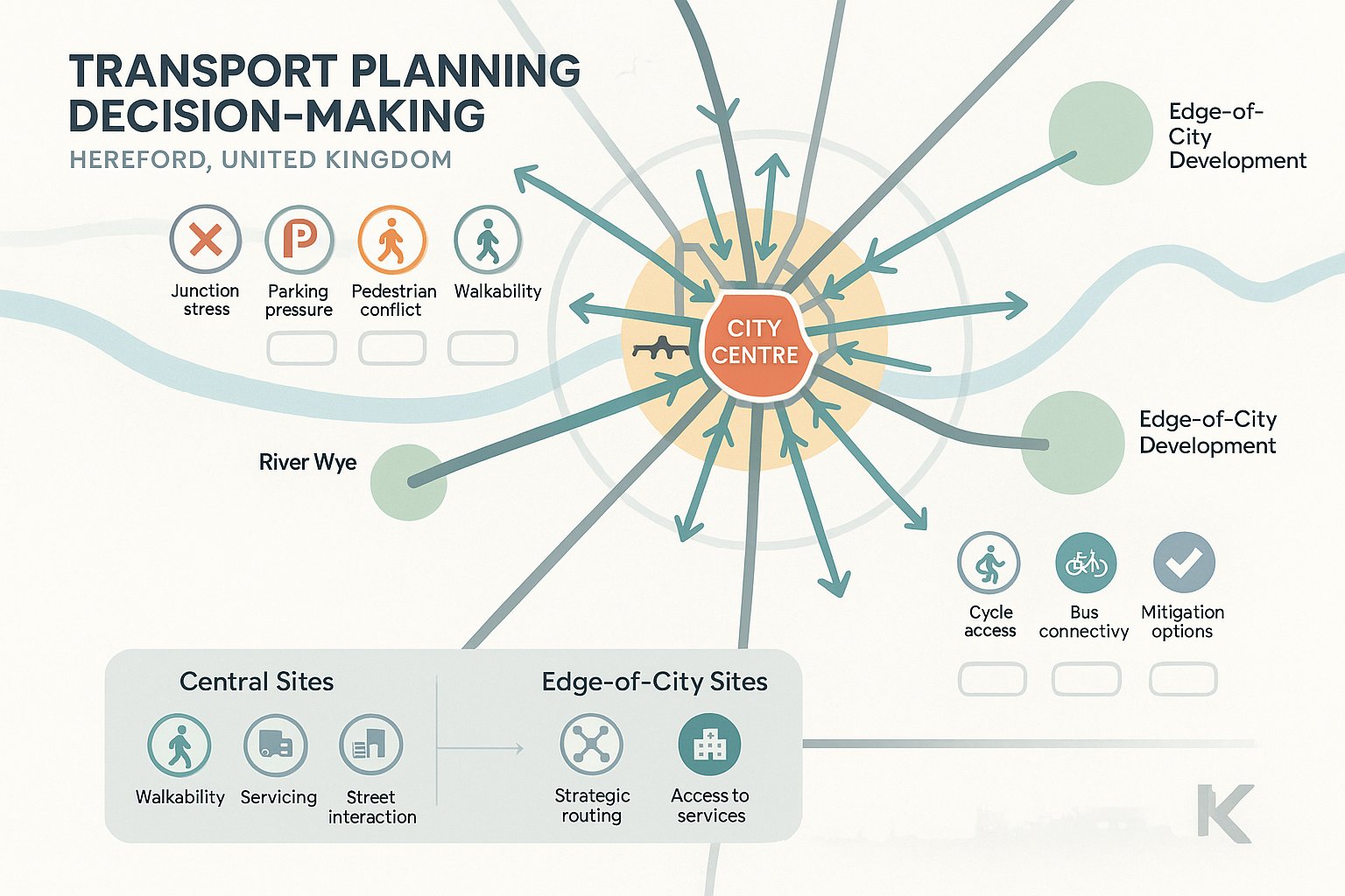
Hereford is not a place where generic transport reporting works especially well. Network conditions, urban form and local policy priorities all shape how planning decisions are made, so transport evidence has to be grounded in the city’s actual operating environment.
Some sites are affected by strategic connectivity and longer-distance movements. Others are much more sensitive to local circulation, school-run pressure, parking displacement or pedestrian access to the centre. In both cases, the local network matters because it determines not just traffic impact, but also what kind of mitigation is likely to be seen as reasonable and effective.
This is one reason transport planning Hereford schemes often need careful site-specific judgement. A development on the edge of the city may raise questions about strategic routing and access to services. A central site may be judged more heavily on walkability, servicing practicality and interaction with existing streets.
The transport case hence needs to reflect where the scheme sits in the network, which travel patterns it is likely to generate, and how it aligns with Herefordshire’s objectives around accessibility, safety and sustainable movement.
Key Constraints Around The City Centre, River Crossings, And Strategic Routes
Hereford’s city centre and river crossings are recurring pressure points in planning discussions for a reason. They play a disproportionate role in connectivity, and when these areas come under strain, the effects can spread quickly across the wider network.
For proposals near the centre, scrutiny often focuses on turning movements, servicing arrangements, pedestrian conflict, parking stress and whether additional vehicle trips are being introduced into already sensitive streets. Historic urban form can limit geometric changes, which means mitigation options are sometimes narrower than teams hope.
River crossings are another obvious issue. Because crossing points are limited, even modest additional demand can become significant if it concentrates in peak periods or relies on corridors that already experience delay and reliability problems.
Strategic routes require the same realism. Freight movement, commuter traffic and regional connectivity all matter, so access design and junction performance need to be tested carefully. If a scheme depends on a route that is already operating close to stress, the evidence has to be especially clear about impact and mitigation.
The Role Of Walking, Cycling, Public Transport, And Accessibility In Scheme Design
In Hereford, sustainable travel is not decorative planning language. It is a material consideration in how schemes are designed and assessed.
Authorities increasingly expect developments to demonstrate how people can reach the site without relying entirely on the private car. That means looking at footway continuity, crossing opportunities, cycle access, secure parking, links to local facilities, bus stop quality, service frequency and routes that feel usable in the real world, not just on a plan.
Accessibility is equally important. A route that technically exists but is poor for wheelchair users, parents with pushchairs or older people will not be viewed as a strong outcome. Inclusive design carries weight, especially where a scheme is expected to serve a broad range of users.
This has practical design consequences. Frontage treatment, internal layout, cycle storage, pedestrian priority, public realm and access to public transport all feed into the transport story. And when these elements are considered early, they tend to strengthen the planning case rather than sit awkwardly beside it.
Done properly, sustainable transport measures are not just mitigation. They improve the quality and resilience of the development itself.
What Local Planning Authorities And Highways Consultees Typically Expect
Local planning authorities and highways consultees are usually looking for three things: a clear understanding of baseline conditions, a proportionate assessment of likely impact, and mitigation that is specific enough to be trusted.
What they do not respond well to is vagueness. Broad statements that a proposal is in a sustainable location or that traffic effects will be minimal rarely carry much weight on their own. Decision-makers normally want to see how those conclusions were reached, what assumptions sit behind them, and whether the evidence reflects local conditions.
In Hereford, that often means aligning the submission with council transport priorities as well as with national planning principles. Authorities will typically expect the report to explain existing travel opportunities, identify any network sensitivities, assess access and safety, and set out whether off-site works, mode-shift measures or operational controls are needed.
Highways reviewers also tend to focus on internal consistency. If the planning statement promises sustainable access, the transport material should show credible walking, cycling and public transport connections. If the layout depends on service vehicles entering and leaving in a certain way, the swept path drawings and servicing note should say the same thing.
From a practical perspective, concise and accurate reporting often helps more than sheer volume. That is one reason firms like ML Traffic emphasise tailored reporting around local authority thresholds and planning context rather than producing oversized technical documents that obscure the key points.
Core Evidence Required To Support A Robust Planning Submission
A robust transport submission is built on evidence that answers the likely planning questions before they are asked. The exact package varies by site, but there is a recognisable core.
Most schemes need a sound description of existing conditions, the surrounding highway context, relevant policy, sustainable travel opportunities and the proposed access strategy. From there, the technical depth depends on scale and sensitivity. For some developments, a concise evidence base is enough. For others, especially larger or more contentious sites, the work may need to extend into detailed modelling, comparative option testing and staged mitigation.
The common thread is that each technical element should support a planning conclusion. Surveys are not collected for their own sake. Capacity tests are not run because software is available. The purpose is to show that the development can function safely and acceptably, and that any residual effects are understood.
Traffic Surveys, Trip Generation, And Junction Capacity Testing
Traffic surveys remain the backbone of many assessments. Without reliable baseline data, even a polished report can unravel quickly under review.
The right survey package depends on the site and likely impact area. That may include junction turning counts, classified link counts, queue observations, parking beat surveys or pedestrian and cyclist counts. Timing matters too. Data should reflect representative conditions and avoid unusual periods unless there is a justified reason to do otherwise.
Trip generation then translates land use into likely travel demand. Good practice usually combines database evidence, local comparators and professional judgement. In Hereford, local characteristics matter: car ownership patterns, service access, school proximity, public transport availability and route choice can all influence trip rates and distribution.
Where junction effects are material, capacity testing is normally expected. The choice of tool depends on the junction type and issue being examined, but the principle is simple enough: show how the network performs with and without development, then test mitigation where needed. Results should be explained in plain English. A decimal place on its own has never won a planning argument.
Access Design, Swept Path Analysis, Parking, And Servicing Evidence
Access arrangements are often where planning discussions become very concrete, very fast.
Authorities will usually want confidence that vehicles can enter, exit and manoeuvre safely, with suitable visibility, geometry and interaction with pedestrians and cyclists. Even where the access itself looks straightforward, details such as gradient, gate set-back, refuse collection strategy or conflict with on-street parking can alter the acceptability of a proposal.
Swept path analysis is commonly required for developments involving larger vehicles, constrained sites or unusual servicing patterns. It demonstrates whether refuse wagons, delivery vehicles, fire appliances or coaches can move through the site without overrun, unsafe reversing or unrealistic manoeuvres.
Parking evidence also matters. Under-provision can create displacement and neighbour objections: over-provision can weaken sustainability arguments and compromise site design. The right balance depends on use, location and available alternatives.
Servicing should be treated with the same seriousness. If a commercial or mixed-use scheme relies on deliveries, collections or management vehicles, the planning submission needs to show where those activities happen, how often, and whether they interfere with network operation or pedestrian quality. A surprising number of delays start with “we’ll sort servicing later”. That rarely goes well.
Common Transport Planning Issues For Residential, Commercial, And Mixed-Use Schemes
Different development types tend to attract different transport concerns, but the themes are familiar.
For residential schemes, common issues include access safety, cumulative traffic growth, school-run interaction, parking pressure and whether pedestrian routes to local facilities are genuinely attractive. On edge-of-settlement or edge-of-city sites, reviewers often look closely at whether residents would be forced into car-based travel for everyday needs.
For commercial development, trip profile matters more sharply. Peak spreading, staff arrivals, servicing demand, HGV routing, customer parking turnover and impacts on nearby junctions can all become central. Industrial and logistics uses may also raise amenity and safety issues if heavy vehicle movements pass through constrained or mixed streets.
For mixed-use schemes, the challenge is usually integration. These projects can perform well from a transport perspective because internal trip capture and varied travel patterns may reduce pressure at any one time. But they also require more careful explanation. Different uses generate different peaks, parking needs and servicing demands, and these must work together rather than compete for space.
Across all three categories, sustainable mode provision is increasingly important. Secure cycle parking, usable walking routes, realistic bus access and inclusive design are no longer “nice to have” extras. In many Hereford schemes, they are part of the difference between a report that reassures and one that invites follow-up questions.
How To Reduce Delays And Objections During The Planning Process
Most planning delays linked to transport are avoidable. Not all, of course. But many come from late scoping, weak evidence, or a mismatch between site design and transport assumptions.
The first way to reduce delay is to start transport input early, ideally before the layout is fixed. That allows access, parking, servicing and active travel connections to be shaped into the scheme rather than patched on afterwards. When transport consultants are asked to defend a design they did not influence, everyone tends to spend more time and money.
Second, scope the work proportionately and, where appropriate, discuss that scope with the council or highways advisers. Agreeing the likely survey area, assessment years, junctions to be tested or travel plan expectations can prevent a long round of post-submission requests.
Third, make the narrative easy to follow. A strong report should explain not just what was assessed, but why those matters are relevant in Hereford. If assumptions are conservative, say so. If there are constraints that cannot be fully removed, explain how they are managed.
And finally, do not neglect sustainable transport measures. Practical walking and cycling improvements, good public transport information, cycle storage, car club consideration, delivery management or phased travel plan measures can all help show that a scheme is taking responsibility for its impact. Objections are less likely when the strategy feels thought through rather than defensive.
Choosing A Transport Planning Approach That Fits Hereford Developments
There is no single template that fits every Hereford site. The right approach depends on scale, land use, location, sensitivity of surrounding streets and the degree to which transport risk could influence planning determination.
For smaller developments with limited impact, a concise Transport Statement supported by access drawings, parking evidence and a short appraisal of sustainable travel may be entirely appropriate. In those cases, clarity matters more than bulk.
For medium-sized schemes, the most effective route is often a proportionate but deeper package: survey data, trip generation, local junction review, access testing and targeted mitigation. This is where many projects sit, and where experienced judgement really matters. Do too little, and the authority may not be persuaded. Do far too much, and teams can waste budget without improving the planning outcome.
For large, mixed-use or sensitive sites, the strategy usually needs to be broader. That may include staged assessment, option testing, detailed junction modelling, travel planning, framework mitigation and close coordination with masterplanning and environmental workstreams.
We generally find that successful transport planning Hereford projects share one trait: the technical work is tailored to the site rather than copied from another town or another scheme type. That is particularly important in a place where local constraints are real and policy expectations around accessibility and sustainable movement continue to strengthen through 2026.
Conclusion
In Hereford, transport planning is rarely just a supporting document. It is often a deciding factor in whether a development feels credible, policy-aligned and deliverable.
The strongest submissions are not always the biggest. They are the ones that match evidence to impact, reflect how Hereford’s network actually works, and address access, capacity, servicing and sustainable travel in a joined-up way. That applies whether the project is a modest residential scheme or a more complex mixed-use proposal near sensitive routes.
For project teams, the message is straightforward: scope early, test assumptions properly, and let transport strategy inform design rather than chase it. That is usually the fastest route to fewer objections and a cleaner planning process.
And if the scheme needs formal transport support, concise local-authority-aware reporting can make a real difference. In a planning environment where detail gets examined closely, clear evidence still wins.
Transport Planning Hereford – Frequently Asked Questions
What is the importance of transport planning in Hereford development projects?
Transport planning in Hereford is crucial because it ensures that new developments support economic growth, accessibility, safety, health, climate goals, and the local environment. It helps demonstrate how proposals will operate on the ground and whether they integrate well with the city’s constrained network and policy requirements.
When is a Transport Statement, Transport Assessment, or Travel Plan required in Hereford?
A Transport Statement is needed for developments with limited traffic impact, a Transport Assessment is required for larger or more complex proposals affecting capacity or safety, and a Travel Plan is necessary when reducing car dependency is a focus. The level of detail depends on the scheme’s scale and local highway conditions.
How do Hereford’s local network constraints affect transport planning decisions?
Hereford’s historic city centre, limited river crossings, and strategic routes create specific challenges. Planning decisions must consider local circulation, pedestrian access, and freight movement. Developments near sensitive corridors or busy junctions face closer scrutiny to ensure safety, accessibility, and minimal disruption to the network.
Why is sustainable travel important in Hereford’s transport planning?
Sustainable travel is a material consideration in Hereford’s planning, emphasizing walking, cycling, public transport, and accessibility. Developments are expected to provide safe, inclusive routes and facilities that reduce reliance on private cars, supporting the council’s climate and health objectives while enhancing site quality and resilience.
How can developers reduce planning delays and objections related to transport in Hereford?
Delays can be reduced by involving transport consultants early to influence design, proportionately scoping transport assessments with the council, providing clear and locally relevant evidence, and incorporating practical sustainable transport measures. This proactive approach aligns with Herefordshire Council’s expectations and helps secure smoother approvals.
What core transport evidence is typically required to support a robust planning submission in Hereford?
Key evidence includes traffic surveys, trip generation analysis, junction capacity testing, access design evaluations, swept path analysis for larger vehicles, parking provision studies, and servicing arrangements. This data demonstrates that developments can function safely and effectively within Hereford’s unique network and meet policy thresholds.