Getting a planning application over the line in Leicester rarely comes down to architecture alone. Time and again, what slows a scheme isn’t the headline idea, it’s whether the transport case is clear, proportionate and properly aligned with local policy from the start. That’s why transport planning Leicester work has become such a decisive part of the planning process for residential, commercial, mixed-use and regeneration proposals.
In practice, Leicester applications sit within a layered framework: national policy in the NPPF, local expectations from Leicester City Council or Leicestershire County Council, the Leicestershire Highway Design Guide, and wider strategic priorities in the Leicester Transport Plan and Local Transport Plan. Together, these shape what counts as safe access, acceptable impact, suitable mitigation and realistic sustainable travel provision.
For architects, planners, lawyers, surveyors, developers and local authority teams, the challenge is usually the same: knowing what level of transport evidence is likely to be needed, when to commission it, and how to avoid the common technical gaps that trigger delays.
In this guide, we set out the practical side of the process. We’ll cover when a Transport Assessment or Transport Statement is usually required, which supporting documents matter most, what evidence local highway officers tend to expect, and how early transport input can make planning applications faster, smoother and more defensible. Where useful, we also reflect the concise, locally tuned reporting approach we use at ML Traffic.
Why Transport Planning Matters For Development In Leicester
Transport planning is not just a technical appendix bolted onto an application. In Leicester, it often becomes the mechanism that proves whether development can function safely, sustainably and in line with policy.
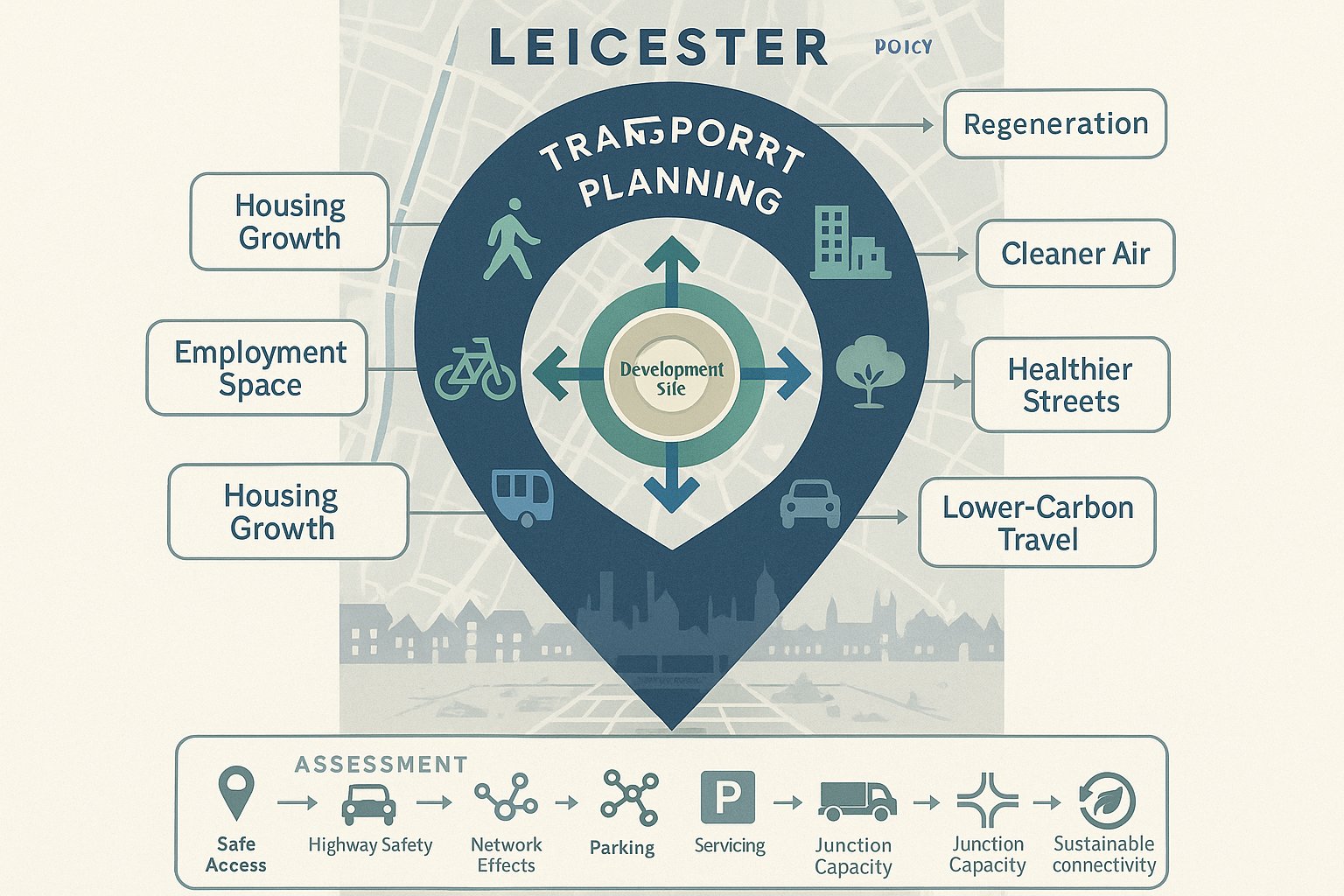
At a strategic level, transport planning supports the things local authorities are trying to deliver at the same time: housing growth, employment space, regeneration, cleaner air, healthier streets and lower carbon travel patterns. Leicester’s transport policy direction places clear weight on walking, cycling and public transport, not simply the free movement of cars. So when a scheme is assessed, the question is no longer just can vehicles get in and out? It’s also whether people can realistically reach the site by other modes.
That matters because the planning test is broader than convenience. Under national policy, development should provide safe and suitable access for all users and should not lead to unacceptable highway safety impacts or severe residual cumulative effects on the road network. A transport submission is the evidence base for those conclusions.
Done well, it helps unlock sites. Done badly, it creates uncertainty around access geometry, parking pressure, servicing, junction performance, sustainable connectivity or road safety. And uncertainty is what tends to stall decisions.
In Leicester particularly, we often see transport planning play a pivotal role on constrained urban sites, redevelopment plots, edge-of-settlement schemes and locations where active travel expectations are high. A proportionate but robust strategy can make the difference between a clean consultation response and a long chain of avoidable objections.
When A Transport Assessment Or Transport Statement Is Likely To Be Needed
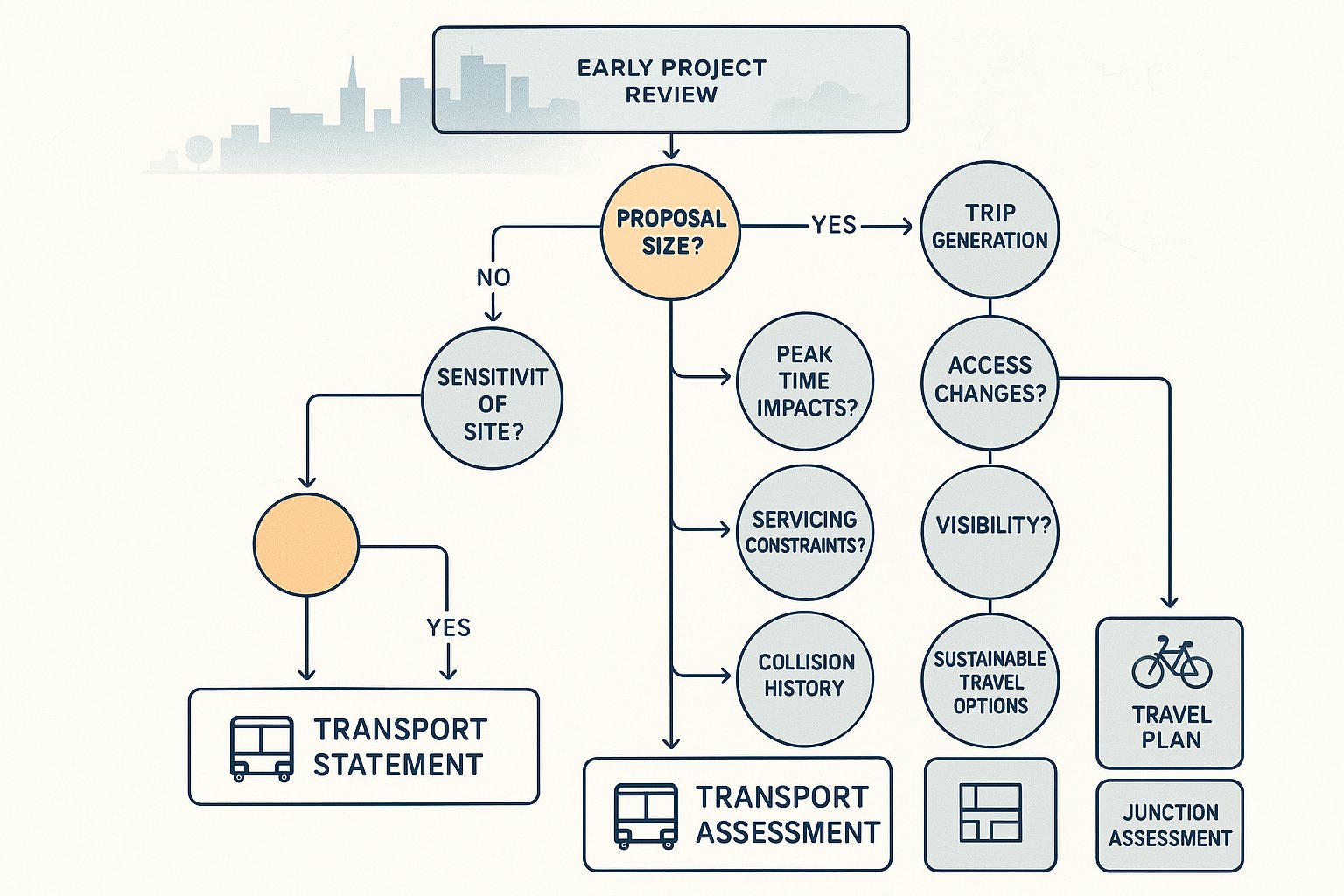
The starting point is proportionality. Not every proposal needs a full Transport Assessment, but many applications in Leicester will need at least a Transport Statement supported by access and parking information.
Broadly, larger developments or schemes likely to generate material traffic and transport effects will require a Transport Assessment (TA). Smaller proposals with more limited impacts may only need a Transport Statement (TS). The dividing line is not purely about floor area or unit numbers in isolation: it depends on the nature of the use, local network sensitivity, site location and the potential for impacts at peak times.
In Leicester and Leicestershire, scope and thresholds are commonly informed by the Leicestershire Highway Design Guide alongside NPPF principles. A town-centre infill scheme with strong bus access may justify a lighter evidence base than a suburban edge site with constrained junctions and fewer sustainable travel options. Equally, a modest proposal can still trigger a more detailed review if access visibility is poor, parking is tight, servicing is awkward or collision history is a concern.
As a rule, we advise clients not to wait for validation comments to decide what’s needed. If the likely trip generation, access changes or policy sensitivity suggest transport is going to be a live issue, early scoping is almost always quicker than trying to retrofit evidence later.
A sensible early review should identify:
- whether a TA or TS is likely to be proportionate:
- whether a Travel Plan will also be expected:
- what survey work is needed:
- which junctions should be assessed: and
- whether pre-application engagement with the highway authority would de-risk the submission.
That upfront judgement saves weeks, sometimes months.
How Leicester’s Local Planning And Highway Context Shapes Transport Requirements
Leicester isn’t assessed in a vacuum. Transport requirements are shaped by national policy, yes, but also by the local authority area involved and the strategic direction of local transport planning.
For sites within Leicester City, applicants need to pay close attention to the city’s transport priorities around active travel, public transport connectivity, place-making and carbon reduction. For sites falling under Leicestershire County Council as highway authority, the Leicestershire Highway Design Guide and county-wide transport expectations become especially important. In some cases, a project can involve planning and highway considerations that cut across administrative boundaries, which makes accurate scoping even more important.
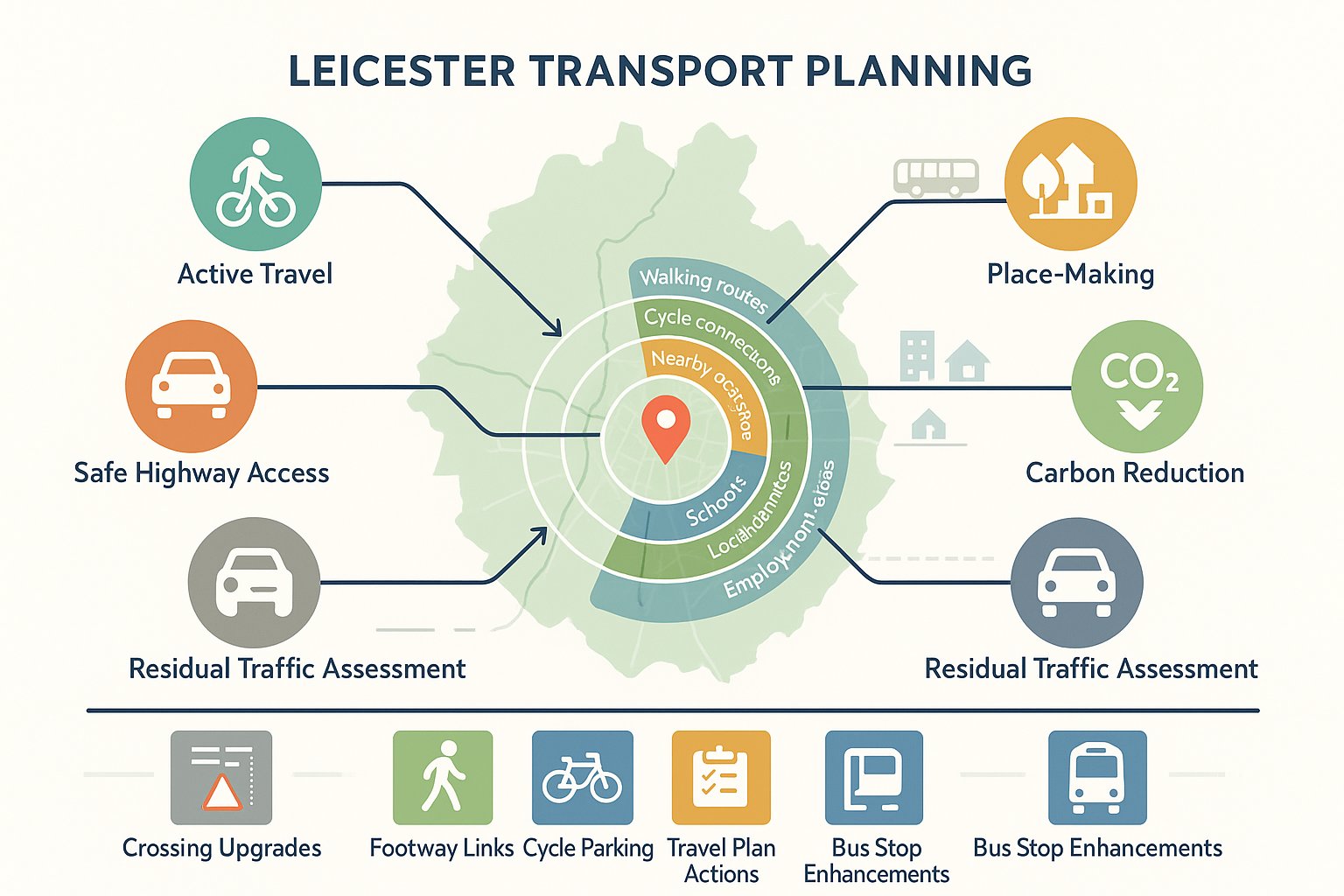
The practical effect of this policy background is straightforward: authorities will usually expect more than a car-based impact note. They want to understand how the development integrates with walking routes, cycle links, nearby bus stops, local services, schools, employment areas and existing network constraints. They will also test whether access arrangements are safe and whether residual traffic impacts are acceptable.
Leicester’s strategic plans push strongly toward sustainable and active travel. That means applicants should be ready to show not only baseline conditions, but also where improvements may be needed, crossing upgrades, footway links, cycle parking, travel plan measures, bus stop enhancements, or contributions secured through condition or obligation.
This is one of the reasons locally informed reporting matters. A generic report can tick boxes. A Leicester-focused submission is more useful because it anticipates the policy themes local officers are already applying. In our experience, that usually leads to sharper documents, fewer clarification requests and a more efficient dialogue during determination.
Key Documents Commonly Required To Support A Planning Application
A planning application involving transport impacts will often need a package of documents rather than a single report. The exact mix varies by scale and use, but there are some recurring requirements in Leicester.
Most commonly, the core submission will include a Transport Assessment or Transport Statement, sometimes accompanied by a Travel Plan. Depending on the site, officers may also expect site access drawings, visibility splays, parking and servicing information, swept path analysis and, where relevant, construction traffic details.
The important point is that these documents need to work together. A sound TA loses credibility if the access drawing shows unresolved geometry. A parking note is weak if servicing hasn’t been demonstrated. A Travel Plan feels superficial if the site’s actual bus and cycle accessibility hasn’t been assessed properly.
Transport Assessment Vs Transport Statement Vs Travel Plan
A Transport Assessment is the more comprehensive document. It typically addresses existing conditions, multi-modal accessibility, trip generation, trip distribution and assignment, junction capacity, road safety, parking, servicing and mitigation. It is the right tool where impacts could be material or contested.
A Transport Statement is lighter-touch and proportionate to smaller or less impactful development. It still needs to be evidence-based, but the analysis is narrower and less modelling-heavy.
A Travel Plan is different again. It focuses on behaviour change, how future users will be encouraged to walk, cycle, use public transport, car share or otherwise reduce single-occupancy car reliance. For larger residential, employment, education, leisure or mixed-use schemes, a Travel Plan is often expected rather than optional.
Site Access, Visibility, Parking, Servicing, And Swept Path Analysis
This is where many applications become very practical very quickly. The authority will want confidence that the site can be accessed safely, with appropriate geometry and visibility for the road context.
Parking provision should align with local standards or be justified where a departure is proposed. On constrained urban sites, that justification needs to be real, not hand-wavy.
Servicing is another frequent pinch point. Delivery and refuse vehicles must be able to enter, manoeuvre and leave safely without causing reversing hazards, obstruction or queueing on the public highway. That is why swept path analysis is so often required. It turns an assumption into evidence.
The Core Evidence Needed To Prepare A Robust Transport Submission
A robust transport submission is built on evidence that is proportionate, current and clearly tied to the development description. If the basics are fuzzy, unit mix, gross floor area, phasing, access points, servicing assumptions, the technical assessment usually wobbles from page one.
At minimum, we would expect the transport evidence to establish the development quantum and land use clearly, describe existing highway and transport conditions, review sustainable accessibility, estimate likely trips, assess the effect on relevant junctions and identify mitigation where needed. For many schemes, a five-year Personal Injury Collision review will also be necessary to understand whether there are underlying safety patterns near the site.
The strongest submissions also show their workings. They explain why certain junctions were selected, why particular survey dates were used, why a TRICS site selection was judged appropriate, and how future-year assumptions were derived. That sort of transparency helps local highway officers review the material efficiently.
Traffic Surveys, Trip Generation, And Junction Capacity Modelling
Traffic survey data remains the backbone of many Leicester transport submissions. Depending on the scheme, that may include junction turning counts, automatic traffic counts, queue observations, parking beat surveys or pedestrian and cyclist counts.
Trip generation is then commonly derived from TRICS or other defensible evidence sources, adjusted where necessary for local context, mixed-use internalisation or pass-by effects. Future-year testing usually covers the application year and a horizon year at least five years ahead, both with and without development.
Where impacts could be material, junction capacity modelling becomes critical. The chosen software and methodology should fit the junction type and the authority’s expectations. But software output alone is not enough: interpretation matters. A technically marginal result may still be acceptable if queues are short, safety is sound and mitigation is practical.
Active Travel, Public Transport, And Accessibility Appraisal
Leicester policy emphasis means accessibility appraisal should never be an afterthought. Officers will want to know whether the site offers realistic opportunities for walking, cycling and public transport use, not merely whether those modes exist in theory.
That means reviewing footway continuity, crossing opportunities, cycle network links, gradients, lighting, severance, bus stop locations, service frequency and access to day-to-day destinations such as schools, shops, employment and health facilities. For some schemes, it also means identifying targeted improvements that make sustainable travel genuinely more attractive.
A good appraisal is specific. It tells the story of the site and what users will experience on the ground. And in Leicester, that can materially strengthen the planning balance.
Common Transport Planning Issues That Delay Leicester Applications
Most transport-related delays in Leicester are not caused by obscure modelling disputes. They’re caused by fairly familiar problems that could have been addressed earlier.
The first is incorrect scoping. We still see applications submitted with a Transport Statement where a fuller Assessment was plainly warranted, or with a TA that omits the junctions officers are most likely to ask about. Once that happens, the determination timetable starts to slip.
The second is lack of early agreement on methodology. If survey extents, assessment years, committed development assumptions or modelling scenarios have not been discussed in advance, the local highway authority may challenge them during consultation. That often leads to additional work rather than a simple clarification.
Third, sustainable transport measures are sometimes undercooked. A report may acknowledge nearby bus stops or cycling routes, but fail to show how the proposal actually supports mode shift. In Leicester, where active travel policy carries real weight, that gap is noticeable.
Then there are the practical design issues: inadequate visibility splays, unresolved refuse tracking, parking layouts that don’t work in operation, or servicing that would force vehicles to wait on-street. These can look minor on plan, but they tend to trigger legitimate technical objections.
Finally, there’s presentation. Dense, generic reports with unclear assumptions create friction. Officers need to understand the proposal quickly. Concise, locally relevant and well-structured reporting, something we prioritise in our own work, usually makes the review process smoother because the important points are easier to test and agree.
How To Improve Approval Prospects Through Early Transport Input
The easiest way to improve approval prospects is simple: bring transport planning in early enough to influence the scheme, not just explain it after the fact.
At feasibility stage, early input helps test whether a site has any obvious access, servicing, visibility, parking or off-site mitigation constraints. That matters commercially. There is little value in progressing a layout that looks efficient on paper but cannot support a safe access or a credible highway case.
Pre-application discussions can then be used to agree the likely scope of the TA or TS, survey requirements, assessment years, junctions to test and any specific local concerns. Even a short, focused scoping exercise can remove a surprising amount of uncertainty.
Early transport involvement also tends to improve design quality. We can work with architects and planners to shape internal layouts, refuse strategies, cycle provision, pedestrian permeability and vehicle manoeuvring before those details become expensive to alter. Lawyers and planning consultants benefit too, because the supporting case becomes more coherent.
From an approvals perspective, the real gain is confidence. A well-scoped submission tells the authority that the applicant understands the site, the policy context and the likely impacts. It reduces the risk of late redesign, repeat surveys or avoidable objections.
That is very much the value of a practical consultancy approach. At ML Traffic, the emphasis is on producing concise, accurate reporting tailored to the relevant authority thresholds and local planning context, because in most applications, speed comes from clarity, not from cutting corners.
Transport Planning For Different Leicester Development Types
Different land uses create different transport questions, and Leicester authorities will expect the assessment to reflect that rather than rely on boilerplate wording.
For residential development, the focus is often on walking and cycling permeability, access to schools and local services, parking provision, visitor parking, EV charging assumptions, refuse collection, and the cumulative effect of peak-hour trips on nearby junctions. For larger schemes, travel planning and internal street hierarchy also become more important.
For employment schemes, especially industrial and logistics uses, servicing and HGV routing can dominate the discussion. Officers will want to understand staff accessibility as well as freight impacts. Shift patterns can matter just as much as daily totals.
For retail and leisure uses, peak-time traffic, linked trips, servicing windows, parking turnover and pedestrian interaction are usually central issues. A site near the city centre may justify a different parking and mode-share strategy from an out-of-centre location.
For mixed-use and regeneration sites, the assessment often becomes more layered. Internal trip capture, phased delivery, parcel-by-parcel access, public realm improvements and cumulative impact with nearby committed development all need careful handling.
And for education, healthcare or community uses, travel behaviour can be highly time-specific. School drop-off patterns, patient transport, taxi activity and on-street stopping can quickly become the key operational issue.
In other words, good transport planning Leicester work is rarely one-size-fits-all. The strongest reports are the ones that understand how the use will actually operate on a Tuesday morning, not just what the land use class says on the form.
What To Expect From The Transport Planning Process From Instruction To Decision
For most schemes, the transport planning process follows a recognisable sequence, although timings vary depending on site complexity and the need for authority engagement.
First comes feasibility: a high-level review of the site, policy context, likely access strategy and probable transport risks. This is where we identify whether the site looks straightforward, constrained or likely to need deeper evidence.
Next is scoping. We define what level of assessment is needed, what surveys should be undertaken, which junctions or links need review, which future years should be tested and whether pre-application discussions are advisable. If the authority can be brought into that conversation early, so much the better.
Then comes data collection and analysis. Surveys are commissioned, baseline conditions reviewed, collision data considered, trip generation established and modelling undertaken where necessary. Sustainable accessibility and site operation are assessed in parallel, not as an afterthought.
After that, we move into reporting and mitigation design. The TA or TS is drafted, a Travel Plan prepared if required, and any highway or site-layout changes are coordinated with the wider design team. This is often where parking, servicing, cycle provision or off-site improvements are refined.
The fifth stage is submission with the planning application. Once consulted, the local highway authority reviews the material and may raise queries. Some are straightforward. Some require revisions, updated drawings or a clearer justification.
Finally, there is determination and agreement of obligations or conditions. If the authority is satisfied, mitigation may be secured through planning conditions, Section 106 obligations or Section 278 highway works.
In short, the process is manageable when it is planned. And that’s really the point: good transport planning is less about firefighting and more about removing uncertainty before it hardens into objection.
For applicants in Leicester, the practical takeaway is this. Start early, scope properly, use evidence that matches the site, and make sure transport is integrated with the design rather than trailing behind it. That approach won’t guarantee approval, nothing does, but it will usually produce a faster, more credible and more resilient planning application.
Transport Planning Leicester – Frequently Asked Questions
What is transport planning and why is it important for development in Leicester?
Transport planning in Leicester ensures developments provide safe, sustainable access for walking, cycling, public transport, and essential car trips. It supports growth and regeneration while addressing climate, air quality, and health goals aligned with local and national policies.
When is a Transport Assessment (TA) or Transport Statement (TS) required for planning applications in Leicester?
A Transport Assessment is needed for larger or more impactful developments, while smaller projects with limited transport effects typically require a lighter Transport Statement. The precise need depends on site location, use, and potential traffic impacts, guided by the Leicestershire Highway Design Guide and NPPF.
How do Leicester City Council and Leicestershire County Council influence transport planning requirements?
They apply national and local policies emphasizing safe access for all users, active travel, and minimising severe highway impacts. Their expectations shape the assessment scope, requiring evidence on walking, cycling, public transport connectivity, parking, and servicing consistent with local Transport Plans.
What key documents support a robust transport planning application in Leicester?
Commonly required documents include a Transport Assessment or Statement, a Travel Plan for larger schemes, site access drawings, visibility splays, parking and servicing details, swept path analysis, and construction traffic information if relevant.
How can early transport planning involvement improve the chances of planning approval in Leicester?
Engaging transport planners early helps identify access, parking, servicing, and mitigation issues before submission. Early agreement with highway authorities on assessment scope reduces delays, improves design quality, and results in clearer, locally relevant reports that smooth the approval process.
What specific transport considerations are essential for residential development planning in Leicester?
For residential schemes, focus is on walking and cycling permeability, access to schools and local services, parking including visitor and EV charging provision, refuse collection logistics, and managing peak trip impacts on nearby junctions to align with city sustainability and safety policies.