Regeneration rises or falls on movement. We can design beautiful homes, flexible workspace, civic squares and new retail frontages, but if people can’t reach them easily, safely and affordably, the scheme starts to unravel long before first occupation. That’s why transport planning for regeneration schemes has become one of the earliest and most commercially important workstreams in 2026.
For architects, planners, lawyers, developers and local authorities, the challenge is rarely just about “traffic impact”. Regeneration projects have to reconcile viability, policy compliance, political scrutiny, community expectations and operational reality on sites that are often constrained, fragmented or historically difficult to access. A town-centre renewal scheme will face very different transport questions from a former industrial brownfield site or a phased mixed-use masterplan. Yet all of them need the same thing: a defensible evidence base, clear strategy, and technical reports that align with local authority expectations.
In our experience, the strongest planning applications don’t bolt transport on at the end. They use it to shape the scheme from the start, access, servicing, parking, active travel, public realm, construction logistics and phasing all working together. That approach not only reduces planning risk, it usually improves place quality too.
In this guide, we set out what really matters in transport planning for regeneration schemes, where projects most often get delayed, and how to build a policy-aligned case that supports consent and delivery.
Why Transport Planning Sits At The Centre Of Successful Regeneration
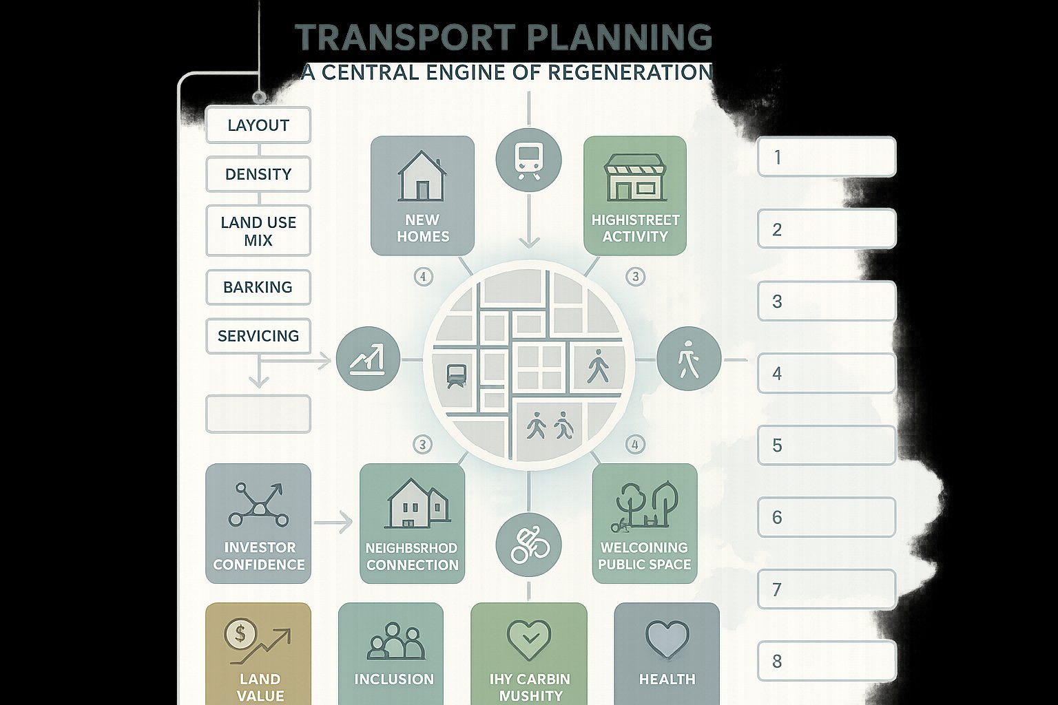
Transport planning is not a supporting appendix to regeneration: it is one of the mechanisms that makes regeneration possible. It determines whether new homes connect to jobs, whether high streets become easier to visit, whether public spaces feel welcoming, and whether a site can operate efficiently once occupied.
At a strategic level, transport unlocks land value and confidence. Investors, occupiers and public-sector partners want to know that a development is accessible, that impacts are understood, and that mitigation is realistic. A scheme that improves connectivity can widen labour markets, increase footfall, reduce severance and help stitch isolated sites back into surrounding neighbourhoods. That is a regeneration outcome, not just a transport one.
There is also a policy dimension. National and local planning frameworks increasingly expect growth to be sustainable, low-carbon and well integrated with walking, cycling and public transport. So the transport strategy has to do more than accommodate vehicles. It needs to support placemaking, health, inclusion and climate goals.
That is why we usually advise project teams to start transport conversations early. On many regeneration sites, layout, density, land use mix, parking levels, servicing approach and public realm design are all interdependent. If transport is considered too late, costly redesign often follows. If it is embedded early, the scheme is usually more viable, more persuasive at application stage and easier to deliver.
How Regeneration Schemes Create Distinct Transport Challenges
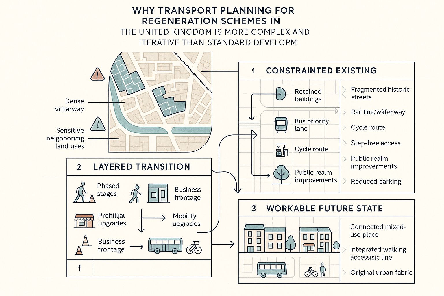
Regeneration schemes tend to be harder than conventional edge-of-settlement development because the transport context is rarely clean or simple. Sites are often constrained by historic street patterns, existing buildings, waterways, rail corridors, neighbouring uses or limited frontage to the highway. Access may be substandard, informal or politically sensitive.
There is also a timing issue. During construction, regeneration can generate disruption on roads, footways and nearby businesses, even when the completed scheme will improve mobility overall. That tension matters because planning officers, highway authorities and local communities will want reassurance on both the short-term impacts and the long-term benefits.
Many regeneration areas also inherit car-dependent patterns that conflict with current policy. We may be trying to retrofit bus priority, cycle links, step-free connections or reduced parking into places that were never designed for them. And where schemes are mixed-use or phased, transport effects can change over time rather than appearing all at once.
In practical terms, this means transport planning for regeneration schemes must be more iterative. We need to test assumptions earlier, engage more frequently with authorities, and make sure the transport narrative explains not just what the final scheme does, but how the site will move from existing conditions to a workable end state.
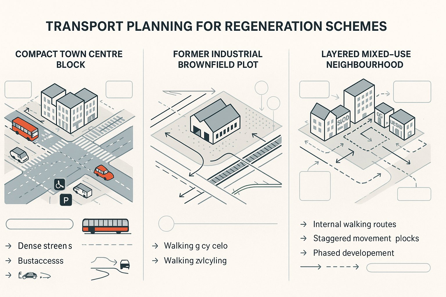
The Difference Between Town Centre, Brownfield, And Mixed-Use Regeneration Sites
The Difference Between Town Centre, Brownfield, And Mixed-Use Regeneration Sites
Not all regeneration sites should be assessed in the same way.
Town centre schemes usually benefit from strong public transport accessibility and a realistic case for lower parking provision. But they often face tight highway geometry, limited kerbside space, high pedestrian flows and strong pressure to prioritise public realm over vehicle movement. Servicing, taxis, blue badge access and last-mile logistics can become the real design challenge.
Brownfield sites are different. They may have legacy industrial access, contamination constraints, weak walking and cycling links, or severance caused by major roads and rail infrastructure. Policy often supports brownfield-first development, but support does not remove the need to prove that the site can be connected safely and sustainably.
Mixed-use regeneration brings opportunities and complexity. Different uses can internally capture trips, residents walking to local retail, office workers using on-site services, visitors arriving outside commuter peaks. That can support viability and sustainability. But mixed-use sites also generate varied servicing needs, overlapping peak periods and more complicated phasing.
The point is simple: the transport strategy must reflect the site typology. Generic assumptions are easy to challenge and often expensive to unwind.
Key Planning Policy And Local Authority Considerations
A robust transport case starts with policy, not modelling. Before we debate trip rates or junction capacity, we need to understand what the development plan, supplementary guidance, parking standards, design codes and local transport strategies are asking for.
In 2026, most authorities expect regeneration schemes to align with a familiar set of principles: brownfield reuse where appropriate, sustainable access, reduced reliance on private car travel in accessible locations, safe active travel connections, inclusive design, and movement strategies that support place rather than dominate it. The precise wording varies by authority, but the direction of travel is clear.
Local nuance matters. One council may focus heavily on town-centre vitality and public realm. Another may scrutinise parking overspill, school-street impacts or bus network integration. Some authorities have specific thresholds for when a Transport Assessment, Transport Statement, Travel Plan or Construction Traffic Management Plan is required. Others place particular weight on road safety audits, accessibility analysis or delivery strategy.
Early engagement with both planning and highway officers is often decisive. It helps us confirm scope, data expectations, modelling methodology and likely pressure points before positions harden. For applicants, that can save months. For local authorities, it means receiving technical submissions that are proportionate, targeted and easier to review. Firms such as ML Traffic build a lot of value here by tailoring reports to local thresholds and authority preferences rather than relying on generic templates.
Building A Robust Evidence Base At The Earliest Stage
When transport work starts late, teams end up arguing from assumptions. When it starts early, they can shape the scheme with evidence. That distinction is huge.
A credible evidence base usually begins with baseline conditions: existing traffic flows, junction performance, collision history, walking and cycling infrastructure, public transport accessibility, parking stress, servicing activity and local constraints. On regeneration sites, we also need to understand severance. Can neighbouring communities actually reach the site on foot? Are there hostile crossings, missing links or inaccessible routes that undermine the masterplan’s claims?
From there, we test likely demand. That may include trip generation, distribution, assignment, mode share assumptions and, where necessary, junction modelling or network appraisal. But numbers alone are not enough. The best evidence base links transport effects to land use, place and policy. For example, if a town-centre scheme proposes restrained parking, the analysis should explain why this is reasonable considering public transport access, walkable catchments and local policy support.
We also need to be realistic about data quality. Regeneration sites with unusual mixes of use or phased delivery can’t always rely on standard databases alone. A judgement-based approach, transparently justified, is often more persuasive than false precision. Highway authorities tend to respond well when the methodology is clear, proportionate and open about uncertainty.
Site Access, Highways Capacity, And Movement Network Appraisal
Access is where strategic ambition meets physical constraint. A regeneration proposal might be sound in planning terms, but if vehicles cannot enter and leave safely, emergency access is compromised, or nearby junctions fail without mitigation, the application becomes vulnerable.
That said, access appraisal should not default to a car-led design response. We need to consider the whole movement network: pedestrian desire lines, cycle permeability, bus routing, servicing paths, blue badge access, emergency vehicles and general traffic. On many regeneration sites, the key question is not whether to maximise highway capacity, but how to balance movement with placemaking.
Highways capacity testing still matters, especially where the development affects sensitive junctions or strategic routes. We may need junction modelling, sensitivity testing, queue analysis or stress testing under different phasing scenarios. But capacity should be considered alongside resilience. What happens if there is an incident, a closure, or peak construction activity? Can the network cope without undermining nearby communities?
A useful movement network appraisal also looks beyond the site boundary. Regeneration can shift routing patterns, attract new crossing movements and change kerbside demand nearby. If those wider effects are ignored, objections often surface late. If they are identified early, mitigation can be integrated into the design rather than bolted on afterwards.
Travel Demand, Mode Share, And Sustainable Transport Strategy
A sustainable transport strategy should be more than a sentence saying residents can walk to a bus stop. Authorities increasingly expect a coherent explanation of how travel demand will be managed and how sustainable mode share will be achieved over time.
That means setting realistic mode share assumptions based on context, not aspiration alone. A highly accessible town-centre site may justify ambitious targets for walking, cycling and public transport with limited parking provision. A peripheral brownfield site may need physical interventions first, new crossings, better bus links, upgraded cycle connections, wayfinding, travel planning measures, before similar targets become credible.
For mixed-use schemes, we should account for internal trip capture as well as external demand. If homes, workspace, leisure and local services are genuinely integrated, some trips disappear from the wider network altogether. That is valuable, but it needs to be evidenced carefully.
Travel Plans remain important here. Done well, they translate strategy into implementation: resident information packs, car club membership, cycle parking management, bus ticket incentives, monitoring and review triggers. They show the authority that mode shift is being actively managed rather than passively hoped for.
The strongest sustainable transport strategies are specific. They identify what infrastructure or operational measures are proposed, who will deliver them, when they will come forward, and how success will be monitored.
Walking, Cycling, Public Transport, And Inclusive Access Priorities
Walking, Cycling, Public Transport, And Inclusive Access Priorities
If regeneration is supposed to reconnect places, then walking and wheeling routes should usually be the first test of success. Can people move directly and safely to schools, stations, shops, health services and open space? Are crossings convenient rather than technically available but unpleasant? Small details matter here, dropped kerbs, gradients, lighting, legibility, passive surveillance.
Cycling requires the same honesty. A token painted lane on a hostile distributor road will not support serious mode shift. What works is continuity: protected routes where needed, calm side streets where possible, secure cycle parking, and links that feel obvious to everyday users rather than confident enthusiasts.
Public transport also needs to be treated as a design input, not an afterthought. That includes walking distance to stops, service frequency, interchange quality, shelters, real-time information and, in some cases, financial support or infrastructure improvements to make services more attractive.
And inclusive access should run through everything. Step-free routes, resting places, tactile paving, accessible parking, manageable crossing times and clear wayfinding are not extras. They are part of whether a regeneration scheme functions for older people, disabled people, parents with buggies and many others. Schemes that ignore this are increasingly hard to defend, both technically and politically.
Managing Servicing, Deliveries, Construction Traffic, And Phasing
A surprising number of regeneration schemes get into trouble not because the end use is unacceptable, but because the day-to-day operations have not been thought through. Servicing, refuse collection, parcel deliveries, contractor access and phased occupation can all trigger objections if left vague.
On constrained sites, off-street servicing is usually preferable, but it is not always simple to achieve. Vehicle swept paths, headroom, turning, waiting space and conflicts with pedestrian areas all need to be resolved in design. Where kerbside activity is unavoidable, time restrictions and management arrangements become crucial.
Construction is a separate but related issue. Highway authorities and neighbours will want confidence on haul routes, booking systems, staff parking, wheel washing, timing restrictions and protection for vulnerable road users. A well-prepared Construction Traffic Management Plan can remove a lot of uncertainty.
Phasing adds another layer. Early phases may operate before the full internal road layout, public realm or sustainable transport package is complete. That can alter access arrangements, trip patterns and servicing behaviour in the short term. We need to explain those interim conditions clearly, identify triggers for mitigation, and make sure obligations are tied to realistic delivery milestones.
In short, operational realism matters. A scheme is easier to consent when the authority can see how it will actually function on a wet Tuesday in November, not just in a glossy masterplan image.
Parking Strategy, Kerbside Management, And Operational Design
Parking is often where policy ambition collides with local anxiety. In accessible regeneration locations, restraint is usually expected, and often justified. But restrained parking still needs a credible operational strategy.
That starts with the basics: how many spaces are proposed, for whom, and why. The answer should respond to local standards, accessibility, land use mix and scheme objectives. Over-parking can undermine sustainable travel claims and consume valuable land. Under-explained under-parking can trigger concerns about overspill into surrounding streets.
Then there is kerbside management. Regeneration schemes generate demand from loading, blue badge users, taxis, private hire, short-stay pick-up, maintenance and increasingly rapid delivery activity. If kerbside function is not designed intentionally, conflict quickly follows.
Operational design should also address electric vehicle charging, cycle parking, motorcycle parking and, where appropriate, car clubs. For some schemes, especially in town centres, a car-free or car-lite approach may be entirely supportable. But it must be backed by evidence, legal controls where necessary, and a strong package of alternative travel options.
The key is integration. Parking should not be treated as a residual land use squeezed into the corners of the plan. It is part of the transport strategy, the public realm strategy and the viability strategy all at once. Done well, it supports all three.
Transport Assessments, Statements, And Related Technical Reports
Most regeneration applications need more than one transport document. The exact package depends on scale, context and local thresholds, but the core purpose is the same: to present a coherent, proportionate and policy-aligned case.
A Transport Assessment is usually required for developments with potentially significant transport implications. It covers baseline conditions, trip generation, mode share, network effects, access arrangements, mitigation and residual impacts. A Transport Statement is typically lighter-touch, suited to smaller or less impactful proposals.
Alongside these, authorities may expect a Travel Plan, Construction Traffic Management Plan, Delivery and Servicing Plan, Parking Strategy, road safety analysis, accessibility work or swept path drawings. On phased regeneration schemes, technical notes on interim arrangements and trigger points can be just as important as the main report.
What matters is consistency. Different reports should not tell different stories about parking, servicing, phasing or mitigation. We have all seen applications where one appendix quietly undermines another. Reviewers spot that quickly.
This is where experienced report preparation earns its fee. Clear structure, authority-specific scope, defensible assumptions and concise explanation make a material difference to determination times. The aim is not to produce the thickest submission. It is to give officers and consultees enough confidence to say yes, with fewer rounds of clarification.
Common Risks That Delay Planning Consent For Regeneration Schemes
Most delays are predictable. The first is underestimating impact. If the authority feels trip rates are too low, servicing is unresolved, or mitigation is vague, it will ask for more work, or simply resist the application.
The second is policy misalignment. A scheme may be architecturally strong but still struggle if the transport approach feels car-led, over-parked or disconnected from active travel and public transport objectives. In 2026, that mismatch is harder to defend than it once was.
Third, teams often engage too late. If highways officers first see the transport strategy at submission stage, they may challenge fundamentals that could have been agreed in principle months earlier. The same applies to local communities, especially where access changes, parking displacement or construction traffic are sensitive.
Another common risk is fragmented consultant coordination. Architects, transport planners, highways engineers, landscape teams and planning consultants can unintentionally produce overlapping assumptions that do not align. The result is friction, revisions and loss of credibility.
And finally, some applications simply fail to explain the regeneration story. They provide data, but not the narrative that links transport choices to wider benefits. Authorities are more likely to support difficult sites when they can see how the movement strategy improves connectivity, inclusion, public realm and long-term place quality, not just network operation.
How To Align Transport Planning With Wider Regeneration Objectives
The best regeneration schemes use transport to do more than manage impact. They use it to create a better place.
That means asking broader questions early. How can the scheme repair severance between neighbourhoods? Can street design support local spending and footfall? Will public realm changes make everyday walking easier for older residents? Can bus access, cycle links or affordable travel measures improve access to jobs and services? These are regeneration questions, but transport is often the delivery mechanism.
It also means working collaboratively. Local authorities, developers, architects, transport consultants, landowners and communities do not always start from the same priorities. Yet the strongest schemes are usually the ones where those priorities are surfaced early and negotiated honestly. A movement strategy that responds to local concerns while still supporting viability is far more resilient than one developed in a silo.
For us, transport planning for regeneration schemes works best when it is integrated from concept to consent to delivery. Not just a technical report near the end, but a thread running through design, planning, operations and phasing.
That approach tends to produce two outcomes at once: a smoother route through planning, and a scheme that functions better for the people who will actually use it. And really, that is the point of regeneration.
Transport Planning for Regeneration Schemes: Frequently Asked Questions
Why is transport planning central to successful regeneration schemes?
Transport planning underpins access to jobs, services, and housing, enabling land value uplift and investment. It shapes placemaking, improves public realm integration, supports social inclusion, and aligns with sustainable, low-carbon growth policies essential for delivering successful regeneration.
How do transport challenges differ between town centre, brownfield, and mixed-use regeneration sites?
Town centres often have high public transport accessibility but face tight road and kerbside constraints prioritising public realm. Brownfield sites may have legacy industrial access issues and connectivity gaps needing remediation. Mixed-use schemes benefit from internal trip capture but involve complex servicing and phased delivery demands requiring tailored transport strategies.
What key policy considerations should be addressed in transport planning for regeneration?
Transport planning must align with national and local frameworks promoting brownfield reuse, sustainable access, reduced car reliance, safe active travel, and inclusive design. Early, iterative engagement with planning and highway authorities ensures compliance with local standards, parking policies, and transport strategies to avoid delays or objections.
How can early evidence base development improve transport planning outcomes in regeneration schemes?
Starting early with baseline data—traffic, public transport, walking and cycling access, and safety audits—allows robust testing of trip generation, distribution, and mode share assumptions. This iterative approach shapes a credible transport narrative, reducing planning risk and supporting a more viable, deliverable regeneration scheme.
What are the best practices for managing servicing, deliveries, and construction traffic in regeneration projects?
Effective management involves off-street servicing where possible, resolving vehicle access and turning constraints, implementing time restrictions on kerbside activities, and preparing Construction Traffic Management Plans (CTMPs) to minimise disruption. Clear phasing and operational realism ensure authorities and communities have confidence in day-to-day site functioning.
How does a sustainable transport strategy support regeneration objectives?
A sustainable strategy sets realistic mode share targets based on site context, enhances walking, cycling and public transport infrastructure, and integrates Travel Plans to encourage mode shift. It supports viability by reducing car dependence, improves connectivity and inclusivity, and aligns with climate and health goals vital for long-term regeneration success.