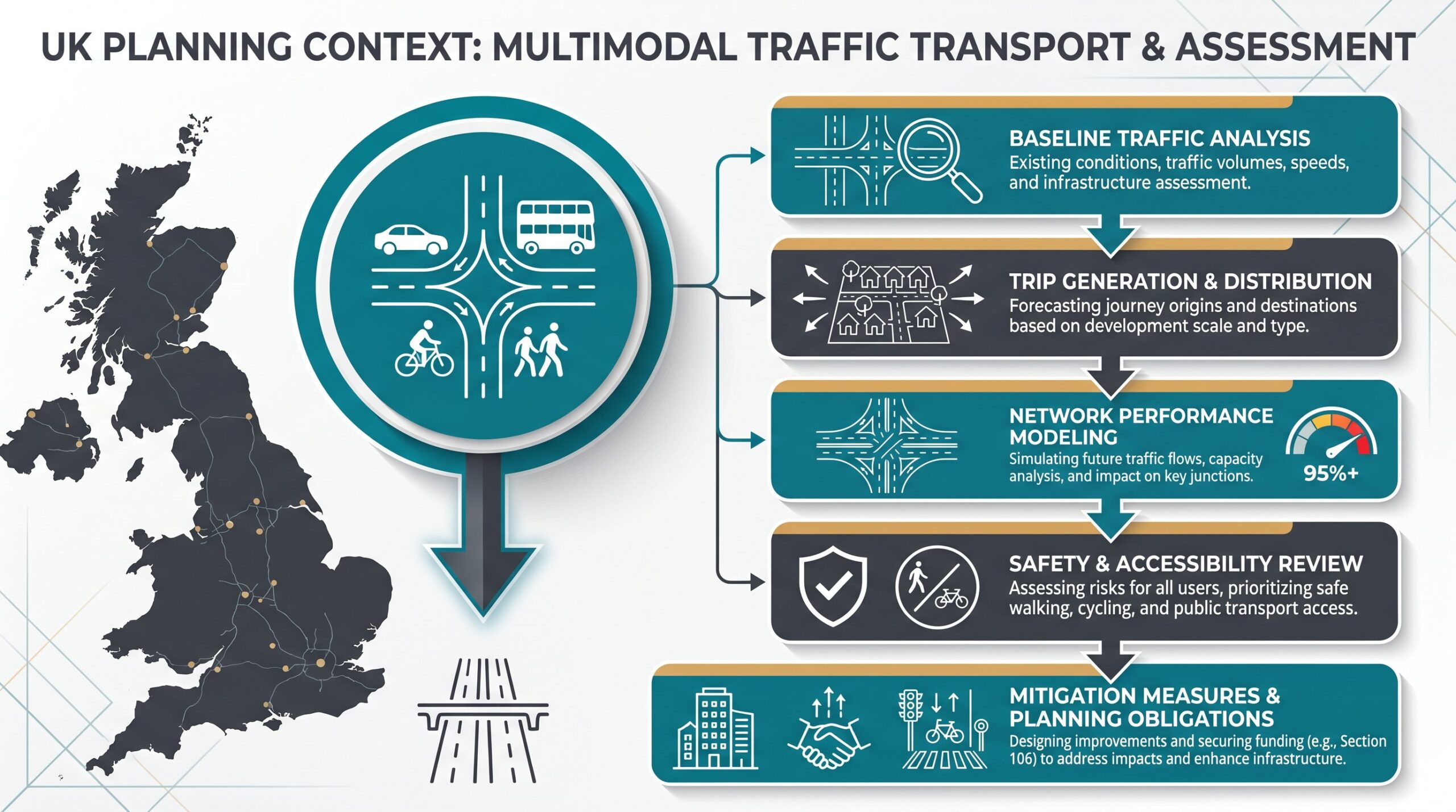
If you’re navigating a planning application for anything more substantial than a garden shed, chances are a local authority will ask whether your development needs a transport assessment. Traffic transport, the art and science of understanding how people and goods move to, from, and around a site, sits at the heart of successful planning decisions. Get it right and you demonstrate safe access, manageable impact, and compliance with policy: get it wrong and you risk refusal, costly delays, or a raft of onerous conditions. This guide walks architects, planners, developers, and councils through what traffic transport really means in the planning context, why assessments matter, what goes into one, and how to commission a report that stands up to scrutiny.
Key Takeaways
- Traffic transport assessments are essential to demonstrate that a development’s impact on traffic, safety, and accessibility is acceptable and manageable under planning regulations.
- A comprehensive transport assessment includes baseline conditions analysis, trip generation and distribution modelling, junction capacity analysis, road-safety reviews, and mitigation strategies tailored to the development’s scale and context.
- Engaging a qualified transport planner early in the design process allows access strategy and site layout to evolve alongside transport planning, avoiding costly revisions after planning submission.
- Combining traditional traffic-count data with emerging sources such as GPS traces and smartphone journey data produces more robust findings and better accounts for uncertain travel behaviour.
- Clear, accessible reporting that translates complex transport modelling into plain language helps planning officers, decision-makers, and objectors understand conclusions and build defensible planning cases.
- Applications for large housing estates, retail parks, major employment sites, or developments in congested or sensitive network areas almost always require a full traffic transport assessment.
What Is Traffic Transport in the Planning Context?
Traffic transport in planning isn’t simply counting cars. It’s the systematic study of how a proposed development will influence traffic flows, junction performance, parking demand, road safety, and accessibility by all modes, car, public transport, walking, and cycling, on the surrounding network.
When land use changes, so does travel demand. A new residential estate generates morning commutes and school runs: a supermarket creates evening peaks and delivery traffic: an office park shifts peak‑hour pressures. A transport assessment quantifies those changes, models their distribution across the road network, and evaluates whether existing infrastructure can accommodate them or whether mitigation is needed.
This process feeds directly into land‑use and transport planning decisions. Highway authorities rely on it to protect network performance and safety: planning officers use it to balance growth with environmental and social impacts. Done well, a traffic transport study becomes the evidence base that unlocks consent and shapes conditions, obligations, and infrastructure contributions.
Why Transport Assessments Are Essential for Planning Applications
Transport assessments aren’t bureaucratic box‑ticking, they’re the mechanism that demonstrates whether a development’s transport impacts are acceptable or require mitigation. Without one, a planning authority has no objective basis to judge safety, capacity, or accessibility, and applications can stall or fail outright.
First, assessments help design access, parking, and internal circulation safely and efficiently. They identify sight‑line issues, pinch points, pedestrian–vehicle conflicts, and servicing constraints early enough to revise layouts before submission. Second, they support decisions on infrastructure investment and the conditions or obligations attached to planning consent. If a junction needs upgrading or a new footway is essential, the assessment quantifies the need and apportions developer contributions fairly.
Third, they address environmental and social impacts, congestion, emissions, severance, and equity of access, aligning development with local transport policy and climate goals. Implementing proven demand management transport strategies can reduce car dependency and ease network pressure. In short, a rigorous transport assessment turns uncertainty into evidence, risk into managed outcomes, and objections into defensible planning cases.
Key Components of a Traffic Transport Assessment
Every competent transport assessment follows a recognisable structure, tailored to the scale and context of the development. It begins with baseline transport and traffic conditions: existing traffic counts, junction performance, accident records, public‑transport provision, and walking/cycling infrastructure. This baseline sets the ‘without‑development’ scenario against which impacts are measured.
Next comes the development description and access strategy, site layout, land uses, floor areas, phasing, and proposed points of vehicular and pedestrian access. The heart of the assessment is trip generation, trip distribution, mode split, and assignment modelling, which we’ll explore below. Junction and network capacity analysis then applies those forecast trips to critical junctions and links, typically using industry‑standard software to model queues, delays, and reserve capacity.
A road‑safety review examines accident clusters, visibility, and vulnerable‑user exposure. The parking strategy traffic engineering element sets out spaces for residents, visitors, disabled users, cycles, and motorcycles, balancing demand with policy minimums or maximums. A servicing strategy covers delivery vehicles, refuse collection, and emergency access, including swept path analysis for larger vehicles.
Finally, the assessment proposes mitigation and improvement measures: junction upgrades, signal retiming, new crossings, travel‑plan commitments, or highway works. These measures turn ‘severe’ impacts into ‘acceptable’ ones and often form the basis of Section 106 or Section 278 agreements.
Traffic Generation and Trip Distribution Analysis
Trip generation estimates how many trips a site will produce and attract, based on land use, floor area or dwelling count, demographics, and empirical rates from similar sites, often drawn from TRICS (the UK’s trip‑rate database). For a 100‑dwelling residential scheme, you might forecast 50–70 two‑way vehicle trips in the morning peak, adjusted for car ownership, public‑transport accessibility, and local context.
Trip distribution then estimates where those trips will come from and go to, using gravity‑type relationships, travel costs (time, distance, tolls), and the size and attractiveness of origin–destination zones. Distribution might show that 40 per cent of commuter trips head towards the nearest town centre, 30 per cent to an employment park, and the rest dispersed across rural hinterlands.
These outputs feed into mode‑choice models (how many will walk, cycle, take the bus, or drive) and route‑assignment models (which roads and junctions they’ll use). Together, trip generation and distribution form the quantitative backbone of the entire assessment, so accuracy and transparency in assumptions are paramount.
When Your Development Requires a Transport Assessment
Not every application needs a full transport assessment: a change‑of‑use of a village shop to a small office probably won’t. But large or traffic‑intensive uses, major housing estates, retail parks, business parks, stadia, or logistics hubs, almost always do. Sites on sensitive networks also trigger assessments: congested corridors, accident blackspots, or junctions already operating near capacity can’t absorb even modest increases without scrutiny.
Proposals generating significant HGV traffic or requiring new accesses onto trunk roads invariably need detailed study, as do developments in locations with poor public‑transport links or pedestrian infrastructure. Local planning and highway authorities publish thresholds and scoping requirements, often in supplementary planning documents or pre‑application guidance. A good rule of thumb: if you’re uncertain, request a scoping opinion early. Authorities would rather agree the scope up front than reject an under‑cooked assessment later.
For smaller schemes, a simpler Transport Statement may suffice, covering the same topics but with less modelling depth. Either way, understanding transport assessment for developments thresholds saves time and budget.
Common Challenges in Traffic Transport Studies and How to Overcome Them
Even experienced consultants hit snags. Data quality and coverage remain perennial issues: manual traffic counts can miss seasonal peaks, household travel surveys suffer low response rates, and older infrastructure lacks automatic counters. The solution is to combine traditional counts with emerging data sources, GPS traces, smartphone journey data, and crowdsourced platforms, to build a more robust picture and cross‑validate findings.
Uncertain travel behaviour complicates forecasting. Car ownership is plateauing in some demographics while rising in others: e‑scooters, car clubs, and remote working shift mode shares unpredictably. Counter this by using the most up‑to‑date local data, testing multiple scenarios (high car use, modal shift, autonomous‑vehicle futures), and presenting sensitivity ranges rather than single‑point forecasts.
Stakeholder conflict is inevitable when residents fear rat‑running, councillors worry about congestion, and developers want minimal conditions. Applying context‑sensitive, performance‑based design that reflects community outcomes, safer crossings, better bus stops, traffic calming, can turn opposition into collaboration. Transparent engagement and multimodal solutions (not just widening roads) build trust.
Model credibility hinges on recognised methods, transparent assumptions, and agreed validation with authorities. Use DfT WebTAG guidance, calibrate models to observed traffic, and document every parameter. When clients and authorities understand and accept the methodology, the conclusions carry weight. Well‑designed mitigation measures traffic interventions can turn potential refusals into approvals.
Best Practices for Commissioning Traffic Transport Reports
Commissioning a transport assessment isn’t something to leave until the week before submission. Engage a qualified transport planner or traffic engineer, preferably one with local knowledge and a track record with your authority, at the earliest design stage. Early involvement means access strategy, site layout, and end to end transport planning can evolve together, not bolt‑on fixes after the masterplan is locked.
Agree scope and methodology with the highway and planning authority before fieldwork begins: study area, survey dates, traffic models, forecast years, development scenarios, and committed developments to include in the baseline. A scoping note signed off by the authority saves arguments later and keeps the assessment proportionate.
Ensure the assessment integrates with site masterplanning and urban design. Transport isn’t a separate technical appendix: it shapes block layout, street hierarchy, parking location, and public‑realm quality. Specify assessment of all modes, pedestrians, cyclists, bus users, and car drivers, and alignment with local transport plans, low‑emission zones, and active‑travel policies.
Finally, require clear, jargon‑light reporting alongside detailed technical appendices. Decision‑makers and objectors shouldn’t need a degree in transport modelling to understand your conclusions. Executive summaries, impact tables, and annotated plans make the case accessible and defensible. With over 30 years of experience, ML Traffic delivers concise, accurate reports tailored to local‑authority thresholds, turning complex analysis into planning success.
Frequently Asked Questions about Traffic Transport in Planning
What is traffic transport in the planning context?
Traffic transport is the systematic study of how a proposed development affects traffic flows, junction performance, parking demand, safety, and accessibility by all modes—car, public transport, walking, and cycling—on the surrounding network. It forms the evidence base for land-use and transport planning decisions.
Why is a transport assessment essential for a planning application?
Transport assessments demonstrate whether a development’s impacts are acceptable or require mitigation. They help design safe access and parking, support infrastructure investment decisions, and address environmental and social impacts such as congestion and emissions, turning uncertainty into defensible planning cases.
What are the key components included in a traffic transport assessment?
A comprehensive traffic transport assessment includes baseline transport conditions, development description and access strategy, trip generation and distribution modelling, junction and network capacity analysis, road safety review, parking and servicing strategy, and proposed mitigation measures such as junction upgrades or travel plans.
How does trip generation and distribution analysis work in transport assessments?
Trip generation estimates how many trips a site will produce based on land use, size, and demographics using databases like TRICS. Trip distribution then forecasts where those trips originate and terminate using gravity-type relationships and travel costs, feeding into mode-choice and route-assignment models.
When does a development require a full transport assessment?
Large or traffic-intensive uses such as major housing estates, retail parks, and business parks typically require assessments. Sites on sensitive networks—congested corridors, accident blackspots, or junctions near capacity—also trigger detailed study, particularly if proposals generate significant HGV traffic or poor public-transport accessibility exists.
What common challenges arise in traffic transport studies and how can they be addressed?
Data quality issues, uncertain travel behaviour, and stakeholder conflict are common. Solutions include combining traditional counts with GPS and smartphone data, testing multiple scenarios, and applying context-sensitive design reflecting community needs. Using recognised methods and transparent assumptions with authority validation builds model credibility and trust.