A commercial scheme can look viable on a site plan and still fail the moment access is tested properly. That’s the awkward reality many of us have seen: the red line fits, the floor area works, the market is there, but the highway piece unravels late, and suddenly planning risk, cost and programme all move in the wrong direction.
Commercial development highway design sits right in that pressure point. It is the practical discipline of making sure a site can be accessed, serviced and circulated safely, while still respecting the function of the surrounding road network, nearby frontages, pedestrians, cyclists and public transport. In other words, it is not just about drawing an entrance. It is about proving that the development can operate in the real world.
For architects, planners, surveyors, developers, solicitors and local authorities, that matters more than ever in 2026. Highway authorities are increasingly focused on evidence, active travel, adoptability, servicing realism and whether mitigation can actually be delivered on land that is within control. The earlier we address those issues, the better our chances of avoiding redesigns, planning delays and expensive technical disputes.
In this guide, we set out what commercial development highway design covers, why it needs attention early, the design principles that usually make or break an application, and the step-by-step process that helps turn a concept into something both approvable and buildable.
What Commercial Development Highway Design Covers
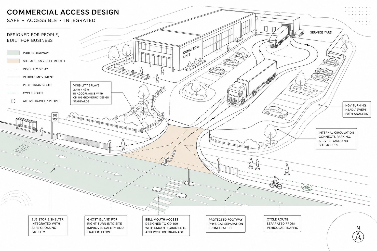
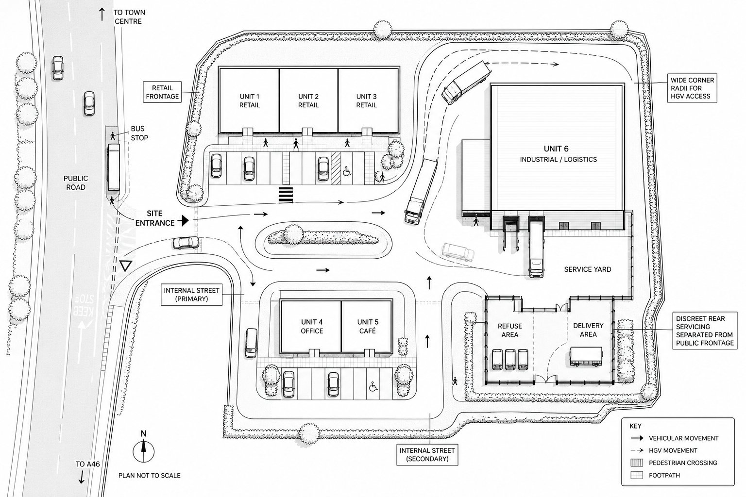
Commercial development highway design covers far more than the access bellmouth shown on a planning drawing. At its broadest, it deals with the relationship between a commercial site and the public highway, then follows that logic through the whole site: arrival, movement, loading, parking, crossing points, and how every user gets in and out without creating avoidable risk.
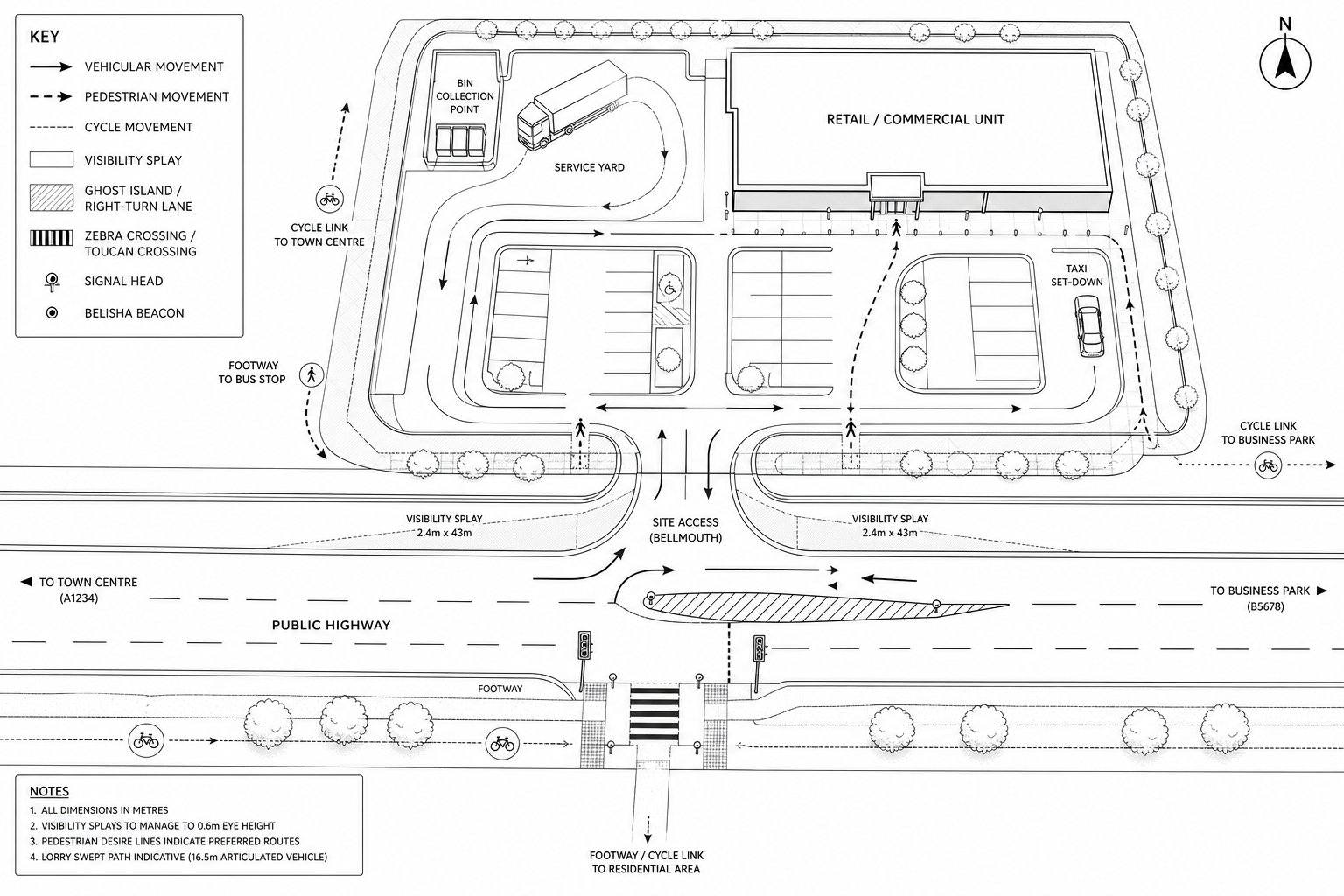
In practice, that usually includes access junctions, ghost islands, right-turn lanes, signal upgrades, frontage treatments, footway works, cycle links, crossing facilities, drainage, lighting, signs, road markings and visibility splays. It also includes what happens beyond the site threshold: internal roads, swept paths, service yards, bin collection points, staff parking, disabled parking, taxi set-down space, and the pedestrian routes people will actually choose rather than the ones we hoped they would use.
The discipline also sits close to transport planning. A layout may appear geometrically acceptable, but if trip generation, distribution or servicing activity do not match the design assumptions, the layout is still weak. That is why commercial development highway design often overlaps with highway infrastructure design and wider development strategy.
For most planning teams, the real test is simple enough: can the proposal integrate safely and efficiently with the surrounding street network, and can that be demonstrated clearly to the local highway authority? If the answer is uncertain, the design is not finished.
Why Highway Design Matters Early In The Planning Process
Highway design matters early because access feasibility quietly controls many of the decisions people think are purely architectural or commercial. Site capacity, unit mix, yard depth, frontage treatment, parking ratios, active travel links and even whether a scheme is realistic at all can depend on what the highway authority will support.
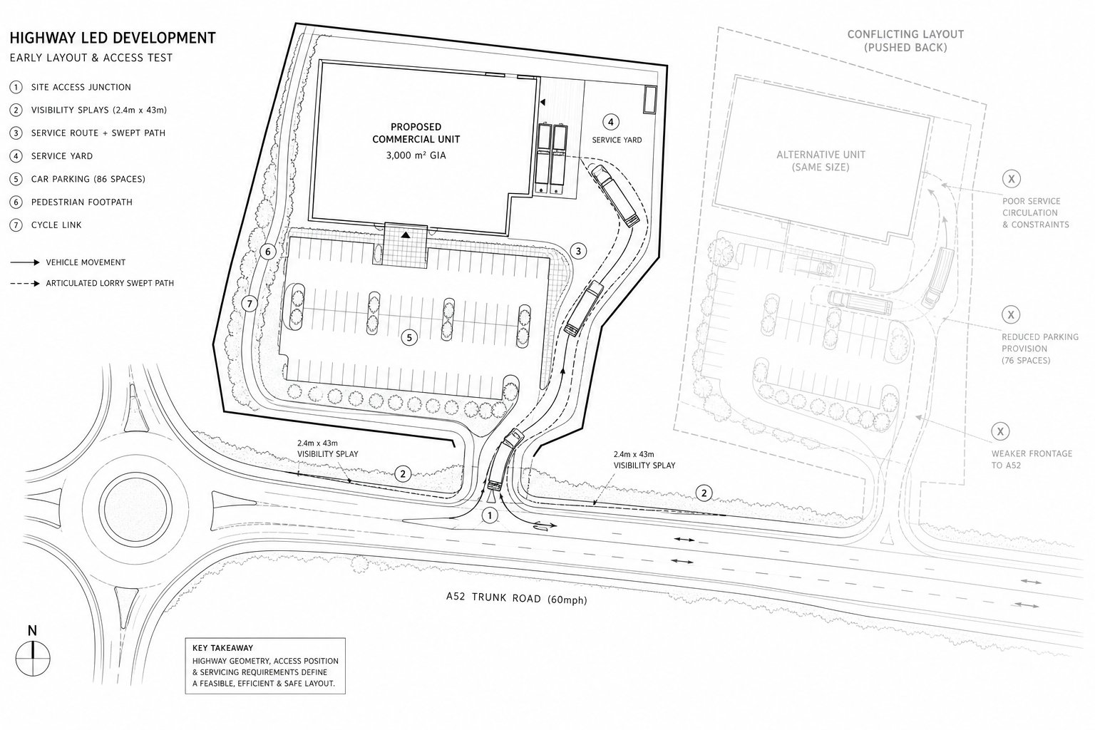
Leave that work too late and the same pattern appears again and again: building footprints need to move, landscaping has to be stripped back to achieve visibility, service routes conflict with customer parking, or off-site works expand beyond the land we actually control. By that stage, redesign costs rise and planning timetables slip.
Early highway input also helps us test whether market assumptions align with network reality. A roadside retail scheme may want strong visibility and direct access, but a busy A-road may need limited turning movements to protect corridor function. An industrial site may look attractive to occupiers, yet still fail if an articulated vehicle cannot circulate without overrunning parking aisles or reversing towards the highway.
This is where concise, front-loaded technical advice tends to pay for itself. A well-scoped Property Development Transport review can identify whether the issue is junction form, trip impact, servicing, or a more basic site layout problem before the design team becomes attached to the wrong solution.
And frankly, highway authorities respond better when they can see the transport and geometric thinking has shaped the proposal from the outset, not been added afterwards to defend a fixed plan.
Core Design Principles For Safe And Efficient Commercial Access
Good commercial highway design is usually quite disciplined. It protects the function of the surrounding road network while still allowing the development to trade, receive deliveries and move people comfortably. That balance is the whole job.
At the strategic level, we normally want as few access points as practical, positioned where drivers can understand them early and use them safely. Shared access arrangements, service roads and coordinated frontage strategies often outperform multiple closely spaced junctions, particularly on busier routes. We also try to reduce conflict points: fewer awkward right turns, fewer places where pedestrians cross service traffic, and fewer moments where HGVs and customer cars compete for the same bit of tarmac.
Clarity matters just as much as geometry. A legible layout tells each user where to go without hesitation. If visitors have to guess where to park, where deliveries unload, or whether a route is one-way, the design is already inviting friction.
Then there is resilience. Commercial sites don’t operate under perfect conditions. Peak trading periods, missed deliveries, courier vans stopping briefly, and refuse collections all test whether the layout still works when it is under pressure.
Vehicle Access, Egress And Internal Circulation
Vehicle access should be simple, properly spaced and proportionate to expected demand. In many schemes, one well-designed point of access is better than two compromised ones. Where separate in and out movements are justified, they need to be genuinely useful rather than decorative geometry that burns land and creates confusion.
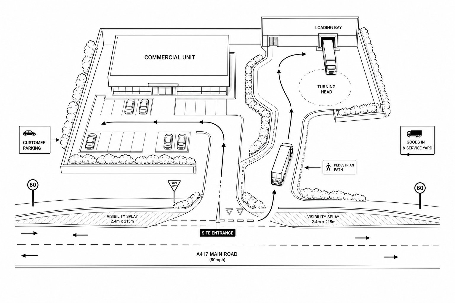
Internal circulation is where many schemes either become obviously competent or obviously fragile. Cars need clear routes to parking without crossing service yards. Service vehicles need turning heads, waiting space and loading areas that allow them to enter, manoeuvre and leave in a forward gear. Reversing within a controlled service area may be acceptable: reversing onto the public highway usually is not.
For industrial and logistics development, swept path design has to be grounded in the right vehicle types, not optimistic assumptions. If the occupier profile suggests articulated vehicles, the geometry should reflect that from day one. On more complex schemes, a traffic impact assessment often helps connect layout decisions with actual movement patterns and peak demand.
The best circulation plans tend to look slightly boring on paper. That’s usually a compliment. They are easy to read, forgiving to use and hard to misuse.
Visibility, Geometry And User Safety
Visibility is still one of the fastest ways for a proposal to run into trouble. If a vehicle cannot emerge with adequate sightlines, or if approaching users are screened by walls, planting, levels or parked vehicles, objections become predictable. Visibility splays should hence be considered alongside boundary treatment, drainage features and landscape design, not after them.
Geometry matters in the same practical way. Junction radii, lane widths, gradients and vertical alignment affect whether vehicles can turn comfortably and whether vulnerable users are exposed to unnecessary risk. A tight radius that slows vehicles can be useful in some contexts, but not if it forces larger vehicles to swing across opposing space or track over footways.
User safety is broader than collision prevention. It includes whether a pedestrian route feels obvious, direct and protected: whether crossing points are placed where people naturally want to cross: whether cyclists are routed through conflict zones: and whether lighting and signing support safe use in poor conditions.
Where there are unusual constraints, robust justification matters. Highway authorities may accept a departure from an ideal standard if the evidence is clear, the risk is understood and the mitigation is credible. But they rarely warm to designs that appear substandard simply because no one dealt with the issue properly.
How Development Type Shapes Highway Design Requirements
Commercial development highway design is not one-size-fits-all. The right solution for a trade counter unit, roadside foodstore, urban industrial estate or mixed-use regeneration plot will differ because the movement patterns differ. That sounds obvious, but many planning problems come from treating unlike schemes as though they share the same operating logic.
A retail-led site tends to generate frequent arrivals, short dwell times, strong pedestrian demand and a sensitivity to convenience at the point of access. Industrial and logistics sites are often defined by larger vehicles, scheduled servicing, staff shift changes and more robust pavement requirements. Mixed-use schemes add another layer: people arrive by different modes, activity can be spread through the day and evening, and the internal street network often has to serve several functions at once.
That means development type should shape the design brief from the start, not merely the final detailing.
Retail, Industrial, Logistics And Mixed-Use Considerations
Retail schemes usually benefit from prominent but controlled access, intuitive parking layouts and strong pedestrian links to adjacent streets, bus stops and neighbouring units. If customers can enter easily but pedestrians have to take a long, exposed route around parking aisles, the design is lopsided.
Industrial and logistics development requires a tougher operational lens. HGVs need appropriate radii, yard depths, gate setbacks and pavement design. Security arrangements matter too: queuing at gates must not spill onto the public highway. In these schemes, highway design consultants are often asked to reconcile occupier expectations with local road constraints and planning policy.
Mixed-use developments are usually the most nuanced. They need an internal hierarchy of streets, service access that does not dominate public frontage, and a realistic integration with public transport and active travel. They can work beautifully, but only if the competing demands are organised rather than layered on top of one another.
Servicing, Delivery Activity And Refuse Collection
Servicing is where glossy plans are often exposed. A scheme may show ample parking and an attractive frontage, yet still fail because delivery vehicles have nowhere sensible to stop, turn or wait. Refuse collection can create the same problem, especially on tighter urban sites where the operational team inherits a layout designed mainly for planning visuals.
Where possible, deliveries and refuse should be routed to side or rear service areas, away from the main customer frontage and primary pedestrian flows. Consolidated service courts usually work better than ad hoc bays scattered around the site. They reduce conflict, improve legibility and make screening, drainage and management easier.
The key point is that service activity must be tested in the way it will actually occur, not how we wish it would occur. What vehicle attends? How often? At what time? Does it wait? Does it need to reverse? Can doors open without blocking circulation? For many schemes, a focused transport assessment for planning applications can pull those operational questions into the evidence base before they become objections.
The Role Of Transport Assessments And Technical Evidence
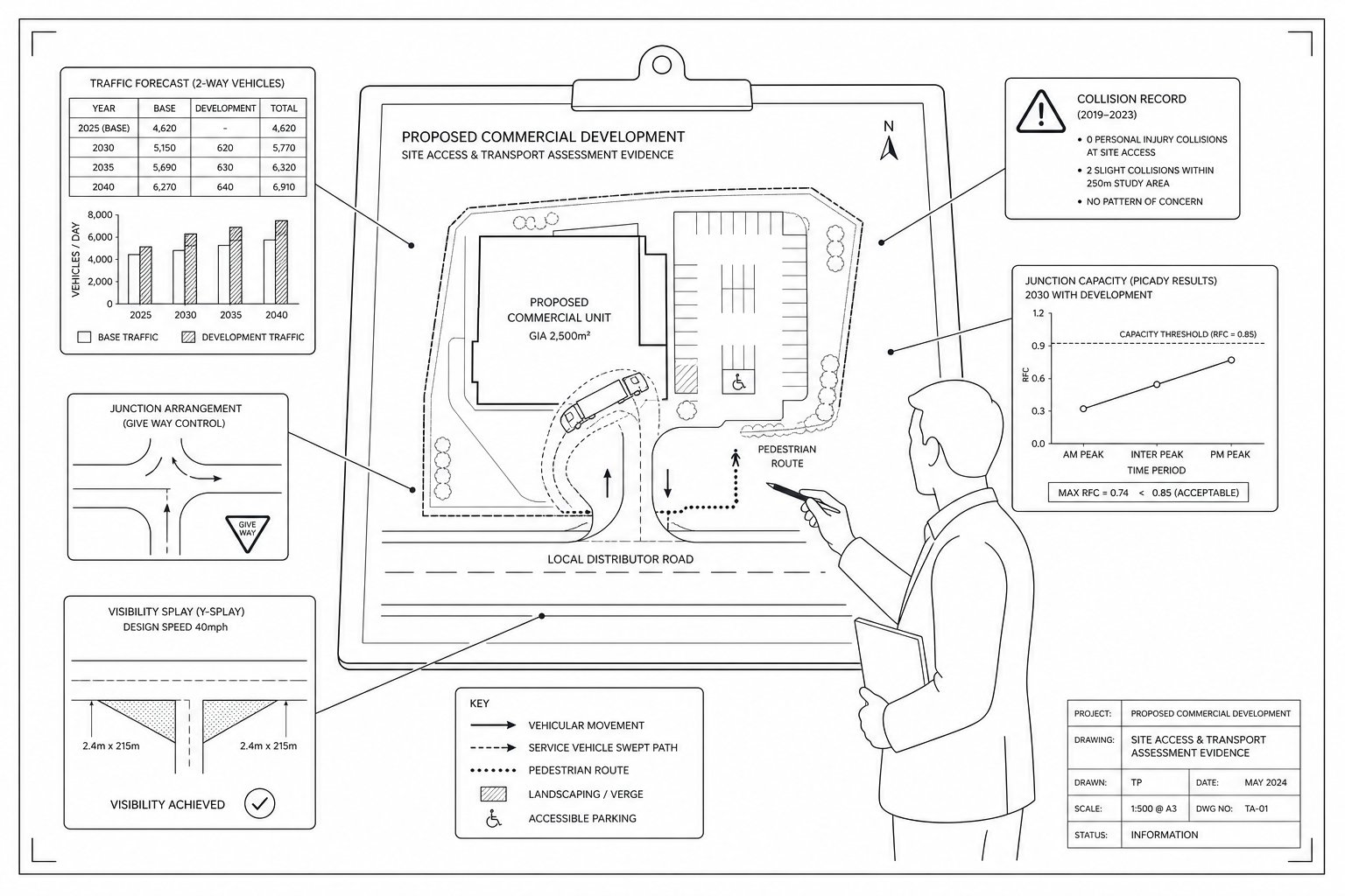
Transport Assessments and related technical notes do two jobs in commercial development highway design. First, they quantify likely movement and network impact. Second, they explain why the proposed layout, access strategy and mitigation are suitable for the specific site.
A good assessment is not just a stack of forecast tables. It links land use, trip generation, distribution, access form, junction modelling, active travel provision, servicing strategy and policy context into one coherent story. If that chain breaks, for example, if trip assumptions do not match the operational plan, or if modelling tests a junction arrangement that differs from the submitted drawing, confidence drops quickly.
The exact scope will vary by authority and development scale, but common components include baseline network review, collision data, committed development, parking analysis, junction capacity assessment, swept path checks and travel planning measures. In some cases, a shorter technical note is enough. In others, a full transport assessment for developments: scheme viability is essential.
Technical evidence also becomes especially important where the design departs from a standard approach. Perhaps visibility is constrained by an existing urban frontage, or perhaps a shared access arrangement is proposed where a stand-alone access might otherwise be expected. Those solutions can still be acceptable, but the burden is on us to show why.
Done well, the technical pack reduces debate by answering the obvious questions before they are formally asked. Done badly, it creates new questions the authority did not have to begin with, which is a painful way to spend a planning programme.
Design Standards, Local Authority Expectations And Adoptability
Standards matter, but commercial development highway design is rarely about applying one document mechanically. In the UK, most projects sit within a framework of national guidance, local highway design guidance, visibility and geometry standards, drainage requirements, safety considerations and authority-specific preferences. The challenge is knowing which standards govern which element, and where local interpretation is likely to be decisive.
For planning purposes, highway authorities will usually want to see that visibility, access form, pedestrian provision, cycle facilities, gradients, levels, drainage and servicing have all been considered against relevant standards. Where works may be offered for adoption, the scrutiny becomes more detailed. Construction thickness, materials, street lighting, kerb lines, drainage outfalls, structures, utilities coordination and long-term maintenance all start to matter in a different way.
That is why adoptability should never be treated as a post-permission technical tidy-up. If the off-site works or estate roads are intended to be adopted, the concept design should already reflect that objective. Otherwise, teams can end up redesigning geometry, levels and drainage after committee resolution, not ideal.
Local authority expectations also vary. Some place strong emphasis on active travel links and public realm quality: others focus heavily on corridor performance, gatekeeping thresholds for assessment, or the detail needed for Section 278 and Section 38 discussions. We find that schemes move more smoothly when the design team understands those local habits early and prepares drawings and evidence accordingly.
In short: standards provide the baseline, but local authority practice often shapes the route to approval and delivery.
Common Highway Design Issues That Delay Planning Approval
Most planning delays in this area are not caused by exotic engineering problems. They usually come from ordinary issues that were either missed, underestimated or left too late.
The first is inadequate evidence on traffic impact. If trip generation is weakly justified, distribution assumptions are vague, or junction modelling does not reflect the submitted layout, the authority has little reason to feel comfortable. The second is substandard visibility or access geometry, especially where boundaries, third-party land or level changes make the proposed solution hard to deliver.
Another frequent issue is too many access points, or accesses in the wrong place. Multiple junctions close together can undermine corridor function, create turning conflicts and reduce frontage quality. Parking is another classic source of trouble: too much in the wrong place, too little for operational need, or disabled and servicing spaces that only work in plan view.
Then there is the undercooked treatment of pedestrians, cyclists and public transport. Authorities are increasingly alert to tokenistic provision, a painted route that leads nowhere, a crossing point detached from desire lines, or cycle parking hidden behind service activity. Those weaknesses can stall an application just as effectively as a poor bellmouth.
And occasionally the delay is more basic still: the works shown on the drawings simply are not deliverable within the red line or under a realistic legal agreement. That is where experienced input in commercial development highway design really earns its place, because deliverability is the detail that turns a technically plausible scheme into a real one.
A Step-By-Step Approach To Commercial Development Highway Design
The most reliable route through commercial development highway design is structured, early and evidence-led. We do not need every detail on day one, but we do need the right decisions in the right order.
First, define the land use quantum and the broad access strategy. That means understanding what the site wants to be, what vehicles it will attract, whether existing frontage can support access, and what the highway authority is likely to accept. Early liaison here is invaluable.
Second, prepare the technical baseline and scope the assessment. That may include surveys, traffic counts, collision review, access appraisals and a framework travel plan. For many projects, this is where a concise traffic impact assessment strategy helps identify whether the constraint is capacity, safety, servicing or policy.
Third, develop the access junction and internal circulation together. They should never be designed as separate exercises. If the bellmouth works but the service yard does not, the scheme does not work.
Fourth, test capacity, safety and operational practicality. That includes modelling where needed, swept paths, visibility checks, pedestrian and cycle movement review, and the practical delivery of refuse and servicing.
Fifth, move from concept to implementable drawings. If the proposal needs off-site works, land checks, drainage coordination and adoptability discussions should be underway before determination, not afterwards.
Finally, secure the necessary agreements, conditions and implementation path. Planning approval is only the midpoint. The real objective is a scheme that can be built, operated and, where relevant, adopted without unpleasant surprises.
Conclusion
Commercial development highway design works best when we treat it as part of development strategy, not a late technical appendix. Access, frontage, servicing and internal circulation all shape whether a commercial proposal is safe, efficient, marketable and capable of securing planning approval.
The strongest schemes usually share the same traits: they address access feasibility early, protect the function of the surrounding road network, provide realistic servicing, and back every design choice with proportionate technical evidence. They also recognise something that planning teams learn the hard way, a layout is only as good as its deliverability.
In 2026, that blend of planning awareness, transport evidence and buildable highway design is what separates smooth permissions from long-running negotiations. If we get those fundamentals right at the start, we give the project a far better chance of moving from concept to consent, and from consent to a working commercial site.
Frequently Asked Questions about Commercial Development Highway Design
What does commercial development highway design include beyond just drawing an access point?
Commercial development highway design encompasses access junctions, right-turn lanes, signals, footways, cycle links, parking, loading areas, pedestrian routes, drainage, lighting, signage, and visibility splays to ensure safe and efficient integration with the surrounding road network.
Why is early involvement of highway design critical in the commercial planning process?
Early highway design input identifies access feasibility, aligns site capacity and mix with network realities, minimises redesigns, reduces planning delays, and ensures proposals meet highway authority expectations for safety and adoptability.
How do vehicle access and internal circulation impact commercial site functionality?
A site should have few, well-spaced access points with separate routes for customers and service vehicles, appropriate turning radii for HGVs, and internal layouts allowing forward movement to maintain safety and operational efficiency.
What role do transport assessments play in commercial development highway design?
Transport assessments quantify trip generation, assess junction capacity, test access options, and provide technical evidence linking land use with road network impact to support planning approval of highway designs.
How does the type of commercial development influence highway design requirements?
Retail sites need prominent access and pedestrian links; industrial/logistics demand larger radii and service yards; mixed-use developments require multimodal access and internal street hierarchies, each shaping design priorities accordingly.
What are common highway design issues causing planning delays, and how can they be avoided?
Delays often stem from poor traffic impact evidence, substandard visibility, too many or badly located accesses, insufficient pedestrian/cyclist provision, and undeliverable works. Early, evidence-led design liaising with authorities helps prevent these.